The vast southern highlands of Mars

Small section of Rocky Highlands

Rocky highlands

Cool image time! This week the Mars Reconnaissance Orbiter (MRO) science team made available its monthly release of new images taken by the high resolution camera on Mars Reconnaissance Orbiter (MRO). The image above is just a small cropped section from one of those new images, released under the name “Rocky Highlands.” The image on the right is a cropped and reduced section of the full photograph, with the white box indicating the small section above. If you click on either you can see the full resolution uncropped photograph and explore its complex and rough terrain.

What should immediately strike you looking at the small inset section above is the difficulty anyone is going to have traversing this country. There are no flat areas. Every inch seems to be a broken and shattered collection of ridges, pits, craters, or rippled dunes. And the inset above is only a tiny representation of the entire image, all of which shows the same kind of badlands.

This forbidding place is located in the southern highlands of Mars, north of Hellas Basin and south of the transition zone that drops down to the northern lowland plains. The white cross on the map below indicates the image location, with green representing the transition zone, blue the northern plains, and red/orange the southern highlands..
» Read more

More ice cliffs found on Mars!

Another ice cliff

In my review of the November image download from the high resolution camera on Mars Reconnaissance Orbiter (MRO), I am, as a cave explorer and cartographer, naturally attracted to any image with “pit” in the title. The image to the right, cropped, rotated and reduced to post here, was released with the title “Pit in Mid-Latitude Mantle”. That immediately caught my eye, and in looking at it I was at first unimpressed. The three apparent collapses are interesting in that they all have south-facing sharp cliffs, but other than that I wasn’t sure why they were of interest.

Then I took at look at this image’s location. It is somewhat far south on Mars, at latitude -60 degrees, sitting south of Hellas Basin, the deepest basin on Mars. This location is in the same general area where scientists announced in January the discovery of eight cliffs with visible exposed ice layers. The white horizontal bar below Hellas Basin on the map below and to the right shows the region where seven of those ice cliffs were located. To quote the January press release:

The location of known ice scarps on Mars

These eight scarps, with slopes as steep as 55 degrees, reveal new information about the internal layered structure of previously detected underground ice sheets in Mars’ middle latitudes.

The ice was likely deposited as snow long ago. The deposits are exposed in cross section as relatively pure water ice, capped by a layer one to two yards (or meters) thick of ice-cemented rock and dust. They hold clues about Mars’ climate history. They also may make frozen water more accessible than previously thought to future robotic or human exploration missions.

Researchers who located and studied the scarp sites with the High Resolution Imaging Science Experiment (HiRISE) camera on MRO reported the findings today in the journal Science. The sites are in both northern and southern hemispheres of Mars, at latitudes from about 55 to 58 degrees, equivalent on Earth to Scotland or the tip of South America. “There is shallow ground ice under roughly a third of the Martian surface, which records the recent history of Mars,” said the study’s lead author, Colin Dundas of the U.S. Geological Survey’s Astrogeology Science Center in Flagstaff, Arizona. “What we’ve seen here are cross-sections through the ice that give us a 3-D view with more detail than ever before.”

In an email correspondence today with Dr. Dundas, he confirmed that the image to the right was of ice cliffs not included in the January paper. The image was a follow-up of an earlier MRO image and was taken to confirm the ice cliff’s existence.

What I noticed in reviewing the January paper was that these three new ice scarps were actually outside the white bar on the map above, located at -60.7 degrees latitude, 83.5 degrees longitude.
» Read more

Present and future landing sites on Mars

With InSight’s landing on Mars set for 11:54 am (Pacific) this coming Monday, November 26, 2018, I decided to put together a map of Mars showing the location of all the successful landers/rovers, adding the landing sites for the planned landers/rovers through 2020. This will give some context to InSight’s landing site.

Landing sites on Mars

The map does not show the landing sites for the failed Soviet, American, and British landers.

As I noted in describing the Mars2020 landing site, the location of the bulk of these landing sites, along the transition zone from the southern highlands and the northern lowlands, demonstrates the areas of the planet that interest geologists the most. It is here that we find many shoreline features, suggestive of the ocean that many scientists theorize existed intermittently in the northern lowlands. It is here that planetary scientists can quickly gather the most information about Martian geological history. And it is here that they have the opportunity to study the widest range of rock types.

From an explorer’s perspective, however, this approach has its limits. It does not provide us a look at a wide variety of locations. It is not directly aimed at finding lower latitude locations where ice might actually exist. And it is decidedly not focused in studying the planet from the perspective of future colonists. I am sometimes frustrated that we have as yet no plans to send any rovers into Marineris Valles, or to the western slopes of Arsia Mons, the southern most volcano in the chain of three giant volcanoes where there are indications that ice might exist underground, or to any of the places where caves are known to exist where a colony could be built more easily. In fact, the caves on the slopes of Arsia Mons seems a prime exploration target.

Eventually these locations will be explored, likely by private landers aimed at scouting out locations for future private settlements. I am just impatient.

The soft landslides of Mars

A soft avalanche on Mars

Context image of landslide

The light gravity of Mars, combined with different materials, a lot of dust, and a geological history different from Earth, produces events that — though reminiscent of similar geological events on Earth — are definitely not the same.

The image above, cropped and reduced to post here, was taken by the high resolution camera on Mars Reconnaissance Orbiter (MRO) and was one of the many uncaptioned images released in the November archive. If you click on the image you can see the full resolution version. It shows the tongue of a landslide inside a crater located in the planet’s southern highlands.

You can immediately see why I call it a soft landslide. The craters on its top are barely visible, as if they hit a soft surface that absorbed most of the impact. The grooves spreading southward in the slide suggest that this solid material flowed almost like mud. And the soft, smooth surface head of the slide suggests an almost liquid-like flow. As far as I can tell, this landslide had few large boulders. It was made up instead of small particles of about the same size.

To the right is an image showing the wider context of the above image, taken by Mars Odyssey and cropped and annotated by me to post here. The white box shows the entire area photographed by the full resolution image of the landslide, with the tongue of the landslide at the bottom of the box. If you look at the floor of this crater, you can see what looks like the ghost of a past smaller impact, seemingly buried in either a field of lava or soft dusty regolith. The smoothness of the crater floor also suggests a material softness, allowing it to settle into a pondlike featureless flat plain.
» Read more

Volcanic rivers on Mars

Granicus Valles

Cool image time! The photo on the right, cropped and reduced to post here, was part of the November image release from the high resolution camera on Mars Reconnaissance Orbiter (MRO). If you click on the image you can see the full resolution picture.

The uncaptioned release webpage is dubbed “Faults in Granicus Valles.” The image itself only shows a small part of Granicus Valles, named after a river in Turkey, that flows down from the estern slopes of the giant volcano Elysium Mons. While far smaller than the four big Martian volcanoes in the Tharsis region to the east and near Marines Valles (which I highlight often), Elysium Mons still outshines anything on Earth at a height of almost 30,000 feet and a width of 150 miles. It sits at about the same northern latitude of Olympus Mons, but all by itself, rising up at the very northern edge of the transition zone between the southern highlands and the northern plains, with the vast Utopia Basin, the second deepest basin on Mars, to the west.

Overview of Elysium Mons and Granicus Valles

Granicus Valles itself is almost five hundred miles long. At its beginning it flows in a single straight fault, but once it enters the northern plains of Utopia Basin it begins to meander and break up into multiple tributaries. The MRO image above shows only a tiny portion in the northern plains, as illustrated by the white box in the overview map to the left.
» Read more

More Pits on Mars!

Pits near Arsia Mons

Cool image time! In the November image release from the high resolution camera on Mars Reconnaissance Orbiter (MRO) were three images, dubbed by me in the collage above as number one, number two, and number three, showing pits south of Arsia Mons, the southernmost volcano in the chain of three giant volcanoes to the east of Mars’s largest volcano, Olympus Mons, and to the west of the Marineris Valles valley.

Mars overview showing pit locations

The image on the right provides the geographical context of the three pits. They are all south of the volcano on the vast lava flow plains that surround it. The location of pits #1 and #2 is especially intriguing, on the east and west edges of what appears to be a large lava flow that had burst out from the volcano, leaving a large lava field covering a vast area several hundred miles across just to the south. You can also see a similar large lava field to the north of the volcano. Both fields appear to have been formed when lava poured through the breaks created by the fault that cuts through the volcano from the northeast to the southwest.
» Read more

The ExoMars 2020 landing site

ExoMars 2020 landing site

Last week the European Space Agency (ESA) announced the final chosen landing site for their 2020 ExoMars rover, a region called Oxia Planum.

Since then they have posted several detailed overview maps describing this region. The image on the right, reduced slightly to post here, shows the final two candidate elliptical landing sites in black, with Oxia Planum on the left. The caption for this image adds this tantalizing detail:

Both landing site candidates lie close to the transition between the cratered northern highlands and the southern lowlands of Mars. They lie just north of the equator, in a region with many channels cutting through from the southern highlands to the northern lowlands. As such, they preserve a rich record of geological history from the planet’s wetter past, billions of years ago.

To understand better what they mean by this, we need to zoom out.
» Read more

The endorsement of election theft

The coming dark age: Voter recounts in three close elections in Florida and Arizona, all won initially by Republicans, now suggest there is significant misconduct going on to favor the Democratic candidates in order to change the results.

Are the local Democrats in Arizona and Florida trying to steal these elections? Maybe. The evidence sure looks that way, based on past behavior. For one thing, in practically every close election requiring a recount in the past two decades the recount somehow always finds more votes for Democrats, sometimes in very suspicious circumstances. Moreover, practically every voter fraud case investigated in the past few years has also appeared to be fraud in favor of the Democrats. While I am sure I could do some digging and find a case or two that was done to favor the Republicans, that would be the exception that proves the rule.

The problem here is not that the Democrats are doing this, but that it has been obvious for the past decade that this party has become very corrupt and power-hungry, and needs a major house-cleaning. Unfortunately, in the election that just passed, the voters across America did not do this. Instead, if anything they gave the Democrats an endorsement, electing them to more seats in the House and not defeating them soundly in the Senate. They also gave them more power at the statewide level, including more governorships.

The result? Americans have essentially told the Democrats they can continue their bad behavior, and in fact are free to expand it as much as they want.

I expect the results of these elections in Florida and Arizona to become Democratic wins. Nor will this be the end. Americans decided it was all right to forgive political corruption, including the most disgusting smear campaign I have seen since the McCarthy era in the 1950s.

Mars rover update: November 8, 2018

Summary: Curiosity finally gets drill samples from the top of Vera Rubin Ridge. Opportunity’s silence now extends to five months.

For a list of past updates beginning in July 2016, see my February 8, 2018 update.

Curiosity

Curiosity's travels on and off Vera Rubin Ridge

For the overall context of Curiosity’s travels, see Pinpointing Curiosity’s location in Gale Crater.

The traverse map on the right, unchanged from my last rover update on July 17, 2018, shows almost all of Curiosity’s travels on Vera Rubin Ridge. The yellow dotted line is the oldest travel, up onto the ridge and then back down to get a successful drill sample. The green dotted line shows the rover’s return back up onto the top of the ridge, where it attempted and failed to drill into the ridge’s top layer, then experienced a serious computer issue in mid-September that essentially shut down science operations for about five weeks.

With the resumption of science operations about two weeks ago, the rover has moved a short distance on the top of the ridge to a new drill location, where it finally succeeded this week in drilling a hole in the hardest top layer of Vera Rubin Ridge.
» Read more

How a monolithic leftist academia poisons America

The coming dark age: To understand how dominant and monolithic the left’s control over America’s modern academic community, one need only to take a scan at this series of research articles being assembled regularly by the website Campus Reform:

Except for SMU, every single one of these colleges is a public institution, funded in great part by tax dollars. Yet, instead of being a vehicle for educating the young about the principles of western civilization which has made them and our wealthy society possible, they have become propaganda machines for the Democratic Party and the leftist socialist/communist utopia dreams that have always led to bankruptcy, poverty, starvation, and societal collapse.

So, have any of the legislatures from the states where these colleges are located done anything about this? Obviously, leftist states like Oregon are likely to applaud the fact that leftist teachers control their colleges, but what about Texas, Georgia, Missouri, Florida? The simple fact is that while we might sometimes have had conservative state legislatures, none of them have had the courage for the past five decades to demand better from these colleges.

Worse, Campus Reform only began this series about two weeks ago. I expect in the coming months they will find that almost every college nationwide is dominated in the same way.

The result is that we have bankrupt intellectual community in the United States. It sees only one right answer to all our problems (government and socialism), and it cannot think deeply about any subject since it has never been challenged to do so. And when it is challenged with alternative ideas or even facts, it acts like a four-year-old having a temper tantrum, running to Twitter to issue short, emotional, insulting attacks at those who dare disagree with its rigid beliefs. Smear tactics become standard operating procedures, and civilized discourse impossible.

And in that atmosphere thugs end up getting elected to office, wielding power for all the wrong reasons.

Unless some effort is made to change this, the political and intellectual culture of the United States is only going to decline further. Unfortunately, I do not see such a major effort happening. For one, there are not very many people in power who wish to do it. Second, it will take great courage and fortitude to stand up to the future temper tantrums that such an effort will produce. In my entire life, I have never seen anyone willing to do it.

Freedom dying

The results of yesterday’s election, when taken in the context of the stories below, confirm for me the sad belief that freedom in the United States is steadily dying. Freedom might return, but for the next few decades I think we are headed for oppressive times. Be prepared.

The stories are only a sampling, and are cited because of what they show: In every case they describe attacks against individuals defending freedom of speech and diversity of thought, and all the attacks come from the students, the future of our society.

The election yesterday further demonstrates the bad future we are facing, not so much that the Democrats won the House after two years of repeated and insane smear campaigns against anyone who opposed them, but because a very very large percentage of the population has decided to support them in that behavior. As I like to say, it’s the audience that counts. The audience here is increasingly oppressive, intolerant, and eager to exercise power to impose its will.

That audience yesterday decided to give power to those who are equally intolerant, and like to wield that power to impose their will.

I could also cite many personal experiences, in just the past few months. The key is that I as a conservative know that if I express my opinions among friends, I will likely lose those friends, and get ostracized. I must choose my words carefully. My liberal friends however feel no such fear, and routinely spout their political views, always assuming that everyone agrees with them.

Meanwhile, I am also gathering that my willingness to express my political views professionally here on my own website has had a negative effect on the website. In recent months certain space aggregate sites no longer link to Behind the Black. Others have even told me that they will block all emails or communications from me.

None of this will stop me from expressing my point of view. It is my curse. I must say what I believe. However, be warned. Bad times are coming. Be prepared.

The vast northern plains of Mars

The vast northern plains of Mars

Cool image time! Actually, this image, found in the October image release from the high resolution camera of Mars Reconnaissance Orbiter (MRO), is not that interesting, in its own right. Context is all!

The image on the right is a small section cropped and reduced in resolution from the full image, which you can see by clicking on it. It shows one of the only interesting features in this long image strip, a small mesa sticking out all by itself in a flat featureless plain pockmarked by various small craters.

The release has no caption, though it is entitled “Northern Plains Survey.” The northern plains, while having a lot of interesting features that attract the attention of planetary scientists and thus get photographed at high resolution, is mostly featureless, at least at the resolution of the wide field survey cameras on many Mars orbiters. In order to know what is really there, they need to take high resolution images systematically, of which this image is obviously a part.

Overview image

The problem is that there is so much ground to cover. This particular image was taken of a spot in the middle of the plains just to the north of the drainage outlets from Valles Marineris, as shown by the context map to the right. The tiny white spot to the right in the middle of the blue plains north of those drainage outlets is the location of this image.

Detail area of overview map

To understand how much ground needs to be covered, to the right is a close-up of the area shown by the white box in the first image above, with red rectangles indicating where MRO has already taken images. The white cross is the subject image. As you can see, most of this immense plain has not yet been imaged. It is almost as if they threw a dart to pick this one location. Most everything around it remains unseen at high resolution. Thus, to understand the geology of this one image is hampered because the surrounding terrain remains unknown, in close detail.

Mars is a big place. It is an entire planet, with the same land surface as the Earth’s continents. It still contains many mysteries and unexplored places. It will take generations to see it all.

Changes on the slopes of Olympus Mons?

Dark splotches on slopes of Olympus Mons

Cool image time! In reviewing the many images from the October image release from the high resolution camera on Mars Reconnaissance Orbiter (MRO), I came across two images, here and here, labeled “Change Detection in Olympus Maculae.” The image on the right is a cropped and reduced section of the first image, centered on the area of most interest. If you click on the image you can see the full photograph.

I did some research to see if I could find the changes indicated by this title. The location is an area on the outer western slopes of Olympus Mons, the largest volcano in the solar system. I found that MRO has taken images of this location twice before, in 2007, in 2009. I spent about fifteen minutes trying to find something that had changed, but was unable to locate anything, other than what look like a few wind-blown streaks probably caused by dust devils. I suspect I do not know what to look for.

Maybe my readers can spend some time and find these changes. If you do, please let us know in a comment.

Nonetheless, these two images revealed an area on the slopes of Olympus Mons that is most intriguing. It appears that there is a whole string of these dark splotches in this area, all of which have been carefully imaged by MRO several times. These splotches, along with the image titles, suggest that this might be area where there is activity from below that is causing the surface to darken. Could it be volcanic? Not likely. More likely is that there is underground frozen water located here, and like the spiders at the poles, this ice periodically pushes up as it sublimates to burst out as gas, and in the process darkens the surface.

If this guess on my part is correct, it suggests that this is an area in the mid-latitudes of Mars where water might be reasonably accessible. For future settlers this would be a significant discovery. And if my guess is wrong no matter. The features are puzzling, which explains why the scientists are aiming MRO at them repeatedly.

If I was to writing my science fiction novel Pioneer today, this is where I would have placed the discovery of the body of the Sanford Addiono, the astronaut who had disappeared on an asteroid near the orbit of Jupiter forty-six years previously. As the press release for the book’s release noted,

How Addiono had gotten to Mars from a distant lost asteroid–without a spaceship–was baffling.

That riddle was magnified by what Addiono had brought back with him. Among his effects was a six-fingered robot hand that had clearly been made by some alien civilization, along with a recorder and memo book describing what Addiono had seen.

What better place to put the start of this mystery but here, on a dark splotch on the slopes of Olympus Mons that also indicates its own geological mystery, a place some underground activity might be reshaping the surface of Mars.

Rappelling in the Grand Canyon

Bob Zimmerman on rappel in the Grand Canyon

This past weekend I was completely out of touch with the rest of the world as I led a group of eight cavers hunting for new caves within the Grand Canyon. This was the fourth trip we’ve done to this part of the canyon, and on previous trips we were either mapping known caves, or scouting with binoculars the cliffs on the mesa’s walls, looking for potential openings. This trip we focused on rappelling down to the most likely candidate openings.

Overall we checked about a dozen potential caves, all of which turned out to be dead ends, mere alcoves. Oh well. Though this might sound disappointing, when you have to rappel off a cliff in the Grand Canyon, dropping out into nothing at heights ranging from 100 to 200 feet, who can complain? The image on the right, taken by Jeff Watkins, shows me (in the orange shirt) in the midst of one of these journeys. I am rappelling about 160 feet down to the top of the alluvial fill that you can see on the left that slopes down another few hundred feet to the canyon floor. In this image I am about a third of the way down, and am about to reach the spot where I will be hanging completely free of the wall.

Yowza! Though you can’t see it in this picture, behind me and opposite the cliff face the canyon extends out several miles to its opposite rim, with the Inner Gorge of the Colorado River cutting across in between. Once I reached the bottom I then rearranged my gear, using it to climb the rope back up 160 feet.

Nor was I the only one to do this. During the weekend we each got to do at least one rappel, each of which was as stunning and as breath-taking in its own right.

To say the experience was exhilarating is for sure a significant understatement. I used to do rappels this deep routinely when I was caving back east, but then the drop was underground, in the dark, with cave walls relatively nearby. Though that had a majesty of its own, doing this in the outdoors, in the Grand Canyon, is a far different thing.

Land of swiss cheese and spiders

Swiss cheese on Martian south polar cap

Time for some cool images! In one of their periodic captioned releases of an interesting high resolution image, the Mars Reconnaissance Orbiter (MRO) science team this week released a picture of the strange “swiss cheese” terrain found throughout the Martian southern polar cap. (I have already highlighted in an early post the spiders that form in the south pole as the carbon dioxide evaporates.) The image to the right is a cropped section of that image, which you can see in its entirety if you click on it.

The South Polar residual cap is composed of carbon dioxide ice that persists through each Martian summer. However, it is constantly changing shape.

The slopes get more direct illumination at this polar location, so they warm up and sublimate, going directly from a solid state to a gaseous state. The gas then re-condenses as frost over flat areas, building new layers as the older layers are destroyed.

The captioned link above also included a link to a gif animation showing how this terrain has changed since 2009. The holes have become bigger, their cliffs retreating with time.

The section I highlight above not only shows the retreating swiss cheese dry ice, you can also see ghosts of several buried craters slowly becoming visible as the dry ice evaporates away.

This is only one of many images taken of the south pole by MRO. In the October archive release, I found almost two dozen, and that’s only the images taken during August of this summer. MRO takes images of the south pole regularly to track its changes, though I suspect it took more this summer because the global dust storm blocked imagery in the middle latitudes. Below and to the right is just one of these images, a particularly good illustration of the swiss cheese formation.
» Read more

First Man: Trivializing the lunar landing

First Man movie flightsuits, without American flag

This past weekend movie-goers finally got to see the world premiere of First Man, a movie based on the biography with the same title telling the life story of Neil Armstrong, the first man to step onto the surface of another world.

Prior to the movie’s release there was some controversy when Ryan Gosling, the actor playing Armstrong, said that they had left out the scene on the Moon when the astronauts planted the American Flag because their goal was to highlight Armstrong’s personal story as well as the global nature of the achievement.

Star Ryan Gosling, who plays Armstrong, defended director Damien Chazelle’s decision to omit the star-spangled moment when asked about it in Venice. “I think this was widely regarded in the end as a human achievement [and] that’s how we chose to view it, ” Gosling said per the Telegraph. “I also think Neil was extremely humble, as were many of these astronauts, and time and time again he deferred the focus from himself to the 400,000 people who made the mission possible.”

The Canadian actor added that based on his own interviews with Armstrong’s family and friends, he doesn’t believe the pioneering astronaut considered himself an American hero. “I don’t think that Neil viewed himself as an American hero,” Gosling said. From my interviews with his family and people that knew him, it was quite the opposite. And we wanted the film to reflect Neil.” [emphasis mine]

Many on the right including myself, strongly criticized this statement. The movies director, Damien Chazelle, immediately responded, saying he was not trying to devalue the importance of the American achievement but to focus instead on telling Neil Armstrong’s personal story. “My goal with this movie was to share with audiences the unseen, unknown aspects of America’s mission to the moon — particularly Neil Armstrong’s personal saga and what he may have been thinking and feeling during those famous few hours.”

I decided I had been unfair to criticize the film without seeing it, and decided I would make a rare trip to a movie theater as soon as it was released to see it and then review it.
» Read more

Honoring the Apollo 8 astronauts

Apollo 8 astronauts Frank Borman, Bill Anders, Jim Lovell

They are still here. Fifty years after becoming the first humans to leave Earth orbit and travel to another world, a mission that NASA believed only had a 50-50 chance of success, the three Apollo 8 astronauts are still with us, hale and hearty despite the passing of many years.

On October 6 the Museum of Science and Technology honored all three men with a magnificent event. The picture on the right was taken during that event, shortly after the three men, Frank Borman, Bill Anders, and Jim Lovell (from left to right) had posed for a typical group shot. It far better reveals their personalities, with Borman looking outward, Anders thoughtful, and Lovell laughing.

Borman and Lovell are ninety years old, while Anders is about to turn eight-five on October 17. Yet, all three remain as sharp as they were in 1968, when they circled the Moon. Only the wear and tear of age and time is slowing them down. It was an honor to see them again and shake their hands. It was also sad, as it was clear that time stops for no one, no matter how deserving. Flying to the Moon on a mission that many thought incredibly risky couldn’t stop them. Time unfortunately will.

We are blessed to still have them. Once again during the dinner presentation they talked of their mission, kidding each other repeatedly about what had happened, and talking about why they went and what they thought the future might hold. Borman was pessimistic about the future of space, but then he remains fixated on the concept of a government program for space. Anders meanwhile was in touch with the rise of private commercial space, and advocated that it is where the future lies.

Lovell was Lovell, as always a space cadet, enthused for the future exploration of space, no matter how we do it.

This event is likely only the beginning. Over the next year there are going to many similar events, celebrating the fiftieth anniversary the 1960s Apollo triumph, right through to the landing in July. To me, however, it will always be Apollo 8 that had the most historical impact. Everything that happened afterward merely reinforced what that flight taught us.

Below the fold are two more pictures from the event.
» Read more

How one region’s space industry represents the world

bumper sticker

On October 2 I attended for the first time a monthly meeting of the Arizona Space Business Roundtable, an informal gathering put together by Stephen Fleming of the University of Arizona’s Strategic Business Initiatives and designed to allow the various space businesses of southern Arizona to network together as well as highlight what they are accomplishing to themselves and to others.

This particular meeting involved the presentation to the business community of a study that looked into the potential growth possibilities for space within the Tucson region. The study had been financed by the University of Arizona, several local venture capital companies, and the local county government, and had found that southern Arizona’s most likely source of space business in the near future would revolve around the need to track and monitor the large number of satellites expected to be launched in the coming decades. This would also involve substantial military work, as well as related space junk clean-up duties. The study also found that the southern Arizona space industry is well suited to provide much of the growing support services that future space missions, both governmental and private, will need. You can read more about the study’s results and the meeting at this Arizona Star article.

What struck me most about this gathering and the space industry of southern Arizona, however, is how much it resembles the regional space industries in numerous other places throughout the United States and the world. In fact, during a panel discussion after the presentation Fleming specifically asked the panelists — made up of several local companies (Vector, Worldview, Paragon) and two venture capital companies — what other regions in the U.S. posed the most competitive threat to southern Arizona. The panelists quickly listed Denver-Boulder, Silicon Valley in California, Huntsville in Alabama, the Space Coast in Florida, and New Mexico. They also made it clear that this list was not complete.

All of these regions are presently prospering and, more important, growing. All see a bright future in space, and all are aggressively competing to grab as large a market share in this future as they can. Even more significant, there appears to be more than enough business to go around. With numerous new countries pushing their own space efforts (China, India, UAE, Great Britain, Luxembourg, to name only a few), and both the American government as well as private companies attempting their own missions to the Moon and beyond, the possibilities appear endless. A lot of government money and investment capital is presently being poured into space, and numerous regions throughout the world are reaching for that money and the future profits it will bring.

And all of these regions are stock full of numerous independent and private companies and individuals, all pushing their own ideas about how space should be explored and conquered.

There are many aspects of the present charge to explore and settle the solar system that I do not like and believe will actually hamper and slow that exploration and settlement. Nonetheless, this charge is happening worldwide, and with amazing and increasing vigor. Even the worst proposals, such as NASA’s Gateway project, are going to eventually lead to new space technologies and capabilities that will sooner or later make it possible for the human race to routinely travel throughout the solar system.

It appears that the next two decades will lay the groundwork for the next few centuries of space exploration. And much of that groundwork will take place out of sight of the general public, with small companies located in regions like these. As with all great endeavors, the structure is that of a pyramid. At the top is the leader (such as SpaceX) that everyone watches and admires. Below it however is a vast subculture that provides the foundation for that leadership, even as it pushes upward to compete against it.

These are exciting times. I suggest if you love space you climb on the rocket now, before it picks up so much speed it will be beyond your reach.

Celebrate Earthrise Day!

In only a little less than three months we will be celebrating the fiftieth anniversary of the December 1968 flight of Apollo 8 — first manned mission to another world. During that mission three humans spent 20 hours in orbit around the Moon, during which they read the first twelve verses of the Old Testament on Christmas Eve and became the first humans to witness an Earthrise and to photograph it.

To celebrate that achievement, a new website has been created, dubbed Celebrate Earthrise Day.

The website provides some great background material. You can listen to the astronaut’s Christmas telecast as well as see a recreation of the moment when the astronauts saw that Earthrise and Bill Anders took his famous color photo. The site also includes many photos from before, during, and after the mission, with many pictures coming from the personal family pictures of the astronauts. There is also audio of an 1988 Bill Anders’ interview, as well as a video of a fascinating presentation made by Bill and Valerie Anders, describing their life journey leading up to Apollo 8 and afterward.

Finally, and I think of most interest to my readers here, the site includes the audio of my introduction from the new audio edition of my book, Genesis: the Story of Apollo 8.

The site also includes the audio of one of the best radio interviews I have ever done, broadcast in 1998, on the subject of Apollo 8, our American culture, and the importance of each person choosing their path in life wisely. You can find that audio at the bottom of this webpage.

Check it all out. I think you will find it worth your while.

A Martian shoreline?

Collapsing cliff in Tempe Fossae

Cool image time! The image on the right, reduced and cropped to post here, was part of the August 31 image release from the high resolution camera of Mars Reconnaissance Orbiter (MRO). (Click on the image to see the full image.) It shows a slowly separating cliff feature in a region dubbed Tempe Fossae

As part of that monthly mass release, no caption was provided for this image. However, we can gain some understanding by looking at the larger context.

Tempe Fossae is located at the margins between the low flat northern plains and the high southern highlands. The location is also part of the vast drainage region to the east of Mars’ gigantic volcanoes. This is obvious from the overview image below and on the right. The location of this image is indicated by the white cross.

Mars overview

In this area of that drainage the canyons appear to follow southwest to northeast trending fault lines. Tempe Fossae is one of the smaller of these canyon complexes. All however appear to drain out into the northern plains.

Most of the MRO images of features in this area focus on the canyon cliffs. This image however focused on this one isolated small cliff in the middle of the canyon. To my eye it appears that these features document the slow drying of that vast intermittent ocean in Mars’s northern plains. The cliff is actually two steps, with the higher one appearing to mark an older shoreline. The lower cliff is abutted by a low flat area where it appears as if there had once been ponded water, now dried.

close-up of cracked area

The cracks in the cliff itself suggest it is slowly breaking apart and falling down towards that low flat area. In fact, the entire feature reminds me of the sand cliffs that are sometimes found along shorelines. The sand is not very strong structurally, and with time sections will separate and then fall down. The image to the right zooms in on this cracked region. The presence of sand dunes reinforces my impression.

I imagine that as the water drained down from the glaciers on the sides of the volcanoes and filled that intermittent sea, the shoreline regions would have had the most water. At Tempe Fossae the canyons might have been partly filled. As the water level drained out and lowered, first the upper cliff edge was exposed, then the lower. The draining water probably helped created these cracks as it flowed down through them.

Finally, the last remaining pits of water ponded at the base of the cliff, eventually drying out. With time, the weakly structured sand cliffs, already carved partly by the flowing water, began to slump apart and fall downward, producing the cracks we now see. I expect that some time in the near future, on geological time scales, there will be a landslide and the outer section will collapse downward.

SpaceX’s first BFR passenger is Yusaku Maezawa, owner of Japanese fashion company

Yusaku Maezawa

Capitalsm in space: SpaceX’s first BFR passenger will be Yusaku Maezawa, the owner of Japanese fashion company, shown on the right.

Maezawa began his statement by echoing John Kennedy with these words, “I choose to go to the Moon.” He purchased the entire first flight, and will invite six to eight artists to join him on the flight and ask them to create art afterward inspired by the flight. They are aiming for a launch in 2023.

BFR

Musk began the presentation tonight with an overview of the status of BFR, noting that they plan unmanned test launches before putting humans on the rocket. The image an the right shows the habitable upper stage.

During the question and answer session after the announcement Musk was asked questions about the present stage of BFR design, and whether it has been finalized. He said they plan “a lot of test flights” and are aiming for first orbital flights in 2 to 3 years, “if things go really well.”

Musk made it clear that Maezawa chose SpaceX for the flight, rather than the other way around. Musk also said that Maezawa was paying them a lot of money for the flight, though they were not going to reveal the amount. Musk did note that the price was not trivial, and that Maezawa has already made a significant deposit. Maezawa had first approached them for a Dragon/Falcon Heavy flight, but because of the limitations of of those spacecraft, they decided it better to go with the bigger rocket.

Musk noted that the first test hops of the upper stage to test its landing capabilities will take place at Boca Chica in Texas. The launch site for the orbital missions is not yet decided.

Musk estimated that the cost for developing BFR is going to probably be around $5 billion, which he also noted rightly is quite small for this kind of project. He also said that right now they are only devoting 5% of SpaceX’s resources to this mission. As they complete the crew Dragon project, they will then begin to shift resources to BFR. He estimated that will happen sometime late next year.

Overall, it strikes me that they really do not have all the details yet worked out, with the rocket or their flight schedule. As Musk openly admitted when asked if they are sure about the schedule, “We are definitely not sure.” This is not necessarily a bad thing, since it is often better to keep an open-mind in planning something this ambitious. At the same time it tells us not to expect any of this to happen, as described.

One final point: Musk at one point said he wants a base on the Moon. “It’s 2018, why don’t we have a base on the Moon?” To me, this was an almost direct dig at NASA’s Gateway/FLOP-G project, which isn’t a base but locks us in lunar orbit. Musk was being very careful to avoid criticizing NASA, his biggest customer, but anyone who knows what is going on will quickly recognize that BFR is in direct competition with SLS/Orion/Gateway.

Based on SpaceX’s history, going from first orbit flight to flying the world’s largest rocket in only ten years, I am very confident that this company could get that first base on the Moon, long before NASA even gets Gateway launched.

Leftist election terrorism

They’re coming for you next: The level of hatred and insanity coming from the partisan left has in the past two years steadily moved from mere vicious hyperbole to increasing violence. The upcoming midterm elections is now fueling this increase in violence, as seen by these stories from yesterday:

The first two stories were generated mostly by Twitter threats, a sewer of such vicious evil. They might not result in violence, but such leftist threats on Twitter are definitely becoming more common. And interestingly, even as Twitter is shutting down conservative speech it seems to have little problem with death threats against conservatives.

The third story however is more worrisome. It is part of a pattern where the insane over-the-top statements by Democratic Party elected officials is fueling a hatred among those who are less than stable themselves, resulting in acts of violence. Nor is this the only story recently where an unstable person attacked something or someone because they were perceived as conservative.

And the craziness on the left shows no signs of letting up, as indicated by the decision of leftist Las Vegas professor to shoot himself in the arm “in protest of President Donald Trump.” Though I have no evidence to support this theory, it appears to me from the story that he might have planned on suicide, but chickened out.

I am very worried that in the next two months we will see at least one attack against Republicans similar to the attempted mass murder last year of Republican congressmen at a charity baseball practice. In fact, I fear that such violence is almost certain.

Armstrong filmmakers purposely obscured American flag

The filmmakers for the Neil Armstrong biography film, First Man, made a conscious decision to hide or obscure the American flag in certain situations.

This new information has been provided to me by a Washington consultant who, because of his own outrage over their decision to not show the planting of the American flag during the lunar landing, had been given the opportunity to see selected clips from the movie as well as ask questions to the production team.

First Man movie flightsuits, without American flag

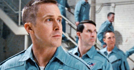
According to that meeting, he learned that they had consciously made the decision to either reposition or remove American flags from the blue flight suits that the astronauts wore from day to day so that it would not be visible. The image on the right, from the movie, illustrates this, as the American flag was almost always sewn into the upper left shoulder of these suits.

The filmmakers also purposely repositioned the flag or filmed angles for many scenes that acted to obscure the flag on the astronauts’ white pressure suits.

The reasons the filmmakers gave for doing this was to enhance their foreign ticket sales.

To this I say, baloney. They might have had this financial excuse, but I think this holds little or no weight. By willingly admitting that they hid the flag in this petty way they have confirmed their political agenda, their desire to convince the world that this mission was not an American achievement but a “human achievement.” Both the film’s Canadian star as well as its director have made it clear they have a globalist vision of the Apollo program, and wanted to spread the credit of its achievement to all humanity. Consciously hiding the flag in this small-minded manner demonstrates their political motives.

Moreover, even though the director, Damien Chazelle, might have wanted to focus on “Neil Armstrong’s personal saga and what he may have been thinking and feeling during those famous few hours,” removing or obscuring icons of the United States serves no purpose other than to remove the United States from this decidedly American moment. Showing the flag on the flightsuits and pressure suits does not make this a jingoistic pro-American propaganda film. Nor does it do anything to prevent Chazelle from telling Neil Armstrong’s personal story. In fact, if anything, hiding the flag detracts from that goal, as Armstrong was very much doing this for his country (as numerous people who knew him have said), and to de-emphasize that reality is to rewrite history in a very dishonest way.

The pettiness of this entire action further outrages me. There is no doubt that sales would not have suffered in foreign countries, in the slightest, had the American flag been left where it belonged on these suits, and had been shown appropriately in other scenes. It accomplishes nothing positive for the film. What it does do is tell us what these Hollywood “artists” think of America.

So that there is no misunderstanding, I must add that neither my source nor I have as yet seen the entire film. It is still possible that these criticisms are unfair, and that the filmmakers might have shown the American flag appropriately in other scenes, and might even have shown it prominently.

Nonetheless, what we now know is that these filmmakers did made a conscious effort to rewrite history so that the United States no longer appeared as prominent in these events as it should have. Once again, it appears to me that these Hollywood filmmakers did this to express their disdain, almost hatred, of the United States and all that it stands for.

For this fact alone I think Americans should reconsider spending any of their hard-earned money on seeing this propaganda piece.

Sunspot update for August 2018: The slide to minimum

As it does the first Sunday of each month, yesterday NOAA posted its monthly update of the solar cycle, covering sunspot activity for August 2018. And as I do every month, I am posting it below, annotated to give it some context.

The Sun in August had a slight uptick in sunspot activity, but not a very significant one. As such, the slide to solar minimum continues. Right now the lack of sunspot activity in 2018 is heading to match or even exceed 2007, the year in which the previous solar minimum began.

August 2018 sunspot activity

The graph above has been modified to show the predictions of the solar science community. The green curves show the community’s two original predictions from April 2007, with half the scientists predicting a very strong maximum and half predicting a weak one. The red curve is their revised May 2009 prediction.

If you look at the original graph at NOAA, you will see that we are getting very close to the right edge of the graph. I expect that sometime in the next few months NOAA will update the graph, a necessary act that will in one sense be a shame, as they have been adding monthly updates to this graph since the beginning of the last solar minimum. This has allowed everyone to see a standard visual, month to month, for comparing solar activity. It has also allowed me to annotate the graph properly to show how the 2007 and 2009 predictions held up against actual activity. Once the graph changes it will be more difficult to do this.

Anyway, it is very clear we are entering solar minimum, and that the solar cycle we are now completing will be both a short and weak cycle. What happens next is really the big question. Will the Sun sunspot activity recover? Or will we enter the first grand minimum since the 1600s? Either way, for solar scientists the coming years are going to be very exciting.

Posted on interstate 10 going from Tucson to Phoenix, on the way to the wooded northern forests of Arizona, where Diane and I will spend a couple of days visiting friends at their upstate cabin/home.

Audiobook of Genesis: the story of Apollo 8 now available

I am pleased to announce the release of the audiobook edition of Genesis: the story of Apollo 8. From the official press release:

This year marks the fiftieth anniversary of one of mankind’s boldest adventures, the first manned flight to another world. To mark the occasion, an audio version of the first book about the mission of Apollo 8 has been released, narrated by Grover Gardner, a legend in the ears of fans of audiobooks all over the planet.

Says Valerie Anders, wife of Apollo 8 crew member Bill Anders, “When I first read this excellent account, published before the end of the space shuttle era, I was delighted.”

Now, with the advent of high quality audio books and online merchants like iTunes and Audible, and the resonant and expressive voice of narrator Grover Garner, everyone can enjoy this recording of this pivotal moment in space history.

While more recent books have been published on the mission of Apollo 8 (most of which rely heavily on Zimmerman’s work), none has captured the impact the Apollo program had on the families of the astronauts nearly so well as “Genesis – the story of Apollo 8.” The new forward to “Genesis,” by Valerie Anders, contains a moving tribute to those pilots who never returned from their missions – not as faraway as the moon, but just as dangerous and far more frequent.

This audio presentation also includes a preface and afterward recorded by the author, Robert Zimmerman, noted science journalist, a member of the National Association of Science Writers, and winner of numerous awards. Grover Gardner has been the narrator of more than 500 books, including many of the most popular audio books ever recorded, including the three part biography of Lyndon Johnson by Robert Caro and Ron Chernow’s Alexander Hamilton. AudioFile magazine refers to him as “one of the best voices of the century.”

“Genesis – the story of Apollo 8” was produced for audio distribution by space fan and Army Lt Colonel William Hartel, who spends his work days as a professor of dentistry at the University of Tennessee. It is available wherever audiobooks are sold and runs 9 hours and 33 minutes.

Contact info: William Hartel, whartel123@aol.com 314-402-5227

You can listen to Grover Gardner’s reading of the foreword by Valerie Anders here.

The audiobook can be purchased directly from all the standard vendors. Or you can get it free with a 30-day trial membership in Audible for $19.99. This costs $2 more than buying the book direct, but this free trial deal will give me a much bigger cut per sale. If you support what I am doing, consider it.

And as always, for those who prefer to read, the ebook edition is also available.

Genesis cover

The ebook edition of Genesis: the Story of Apollo 8 includes a foreword by Valerie Anders and a new introduction by Robert Zimmerman.


Available everywhere for $5.99 (before discount) at amazon, or direct from the publisher, ebookit. If you buy from ebookit the author gets a bigger cut much sooner.

 
The audiobook is also available at all these vendors, and is also free with a 30-day trial membership to Audible.


“Not simply about one mission, [Genesis] is also the history of America’s quest for the moon… Zimmerman has done a masterful job of tying disparate events together into a solid account of one of America’s greatest human triumphs.”
–San Antonio Express-News

Hollywood once again reveals its distaste for America

The just released new Hollywood movie detailing the life of Neil Armstrong, First Man, has so far gotten rave reviews.

Sadly, however, there is one detail about the Apollo 11 mission that the filmmakers decided they couldn’t include, even though it was in many ways the entire point of the mission. They made a conscious decision to exclude any mention of the planting of the American flag on the surface of the Moon.

Star Ryan Gosling, who plays Armstrong, defended director Damien Chazelle’s decision to omit the star-spangled moment when asked about it in Venice. “I think this was widely regarded in the end as a human achievement [and] that’s how we chose to view it, ” Gosling said per the Telegraph. “I also think Neil was extremely humble, as were many of these astronauts, and time and time again he deferred the focus from himself to the 400,000 people who made the mission possible.”

The Canadian actor added that based on his own interviews with Armstrong’s family and friends, he doesn’t believe the pioneering astronaut considered himself an American hero. “I don’t think that Neil viewed himself as an American hero,” Gosling said. From my interviews with his family and people that knew him, it was quite the opposite. And we wanted the film to reflect Neil.” [emphasis mine]

This is bunk. All the astronauts who flew to the Moon were very aware that they were warriors in the Cold War against the Soviet Union and communism, and did it very consciously so that the U.S. could win that space race, for the U.S. Planting the flag was thus for them a very important aspect of the mission, maybe in many ways the most important.

That these Hollywood filmmakers purposely excluded that moment only illustrates to me once again the hostility, even hate, that the modern elitist culture has for the United States and everything it has stood for since 1776: freedom, blind justice before the law, and individual responsibility. Here it appears they are making an effort to separate that very decidedly American culture, which made the lunar landing possible, from that achievement. They want to honor Armstrong as an individual, but do not want to give any credit to the country and culture that sent him to the Moon. Instead, they want to claim that the Apollo landings were merely “a human achievement.”

For shame.

This makes me very unwilling to spend any money to see this movie. Why should I support the work of such intellectually dishonest people?

I must add that I have already been emailed by several readers who are similarly outraged. I wonder therefore if this will turn into something that will actually hurt ticket sales. I suspect not, as too many Americans today do not care very much about these issues. They will go to be entertained, and many will buy into the lie that the Apollo missions was an achievement not of America but of the entire global world, working together in love and peace.

The search for Mars Polar Lander

A small section where Polar Lander might have crashed

In December 1999 the U.S. lander Mars Polar Lander was to set down near the southern polar cap of Mars. After an almost routine eleven month journey to Mars, all efforts to contact the spacecraft after its landing failed. A NASA review eventually concluded that the spacecraft had prematurely shut down its landing engines while the spacecraft was still far above the surface, and had therefore crashed to the ground.

Since then there have been extensive efforts to locate the lander’s remains on the surface, all to no avail. Though Mars Global Surveyor, in orbit at the time, tried to find it, its resolution was not sufficient. In recent years Mars Reconnaissance Orbiter (MRO) has taken several dozen high resolution images of the estimated landing area, two of the most recent were included in the August 2018 image release. The image on the right is a cropped section of one of those images, illustrating the difficulty of the search. (If you click on the image you can explore the full version.) The other image is quite similar.

As the southern polar cap shrinks and grows seasonally, it produces endless numbers of black spots from the release of underground dust as the carbon dioxide dry ice sublimates into gas. Moreover, the growth and retreat of the dry ice cap changes the landscape, periodically covering any remains of the rover as well as quickly removing many of the ground disturbances that the crash might have caused. In the almost two decades since the lander’s crash landing, about ten Martian years have passed, meaning that cap has melted and frozen ten times over this region in that time.

Images taken by MRO of Mars Polar Lander landing area

The image on the right shows the footprint of all the images that MRO has so far taken of the Mars Polar Lander landing area. If you are ambitious and want to get your name in the news, all you have to do is spend some time combing through those images and find the lander there. Every one of these images is available for public download at full resolution. Go to HiRise image archive, hover your mouse over latitude 77 degrees south, longitude 166 degrees east, and click several times to zoom in. You then change the selector icon at the top from “+” to “the arrow”. When next you click on any portion of that footprint it will show you a bunch of the images taken, all of which you can now download and inspect.

If you are successful and find the lander, please let me know. It would be nice to make that announcement here on Behind the Black.

Trump administration goes all in for LOP-G

The swamp wins! In a speech today Vice President Mike Pence made it clear that the Trump administration is giving its full endorsement to the construction of the Lunar Orbiting Platform-Gateway (LOP-G), as well as SLS and Orion. These big boondoggles, which will trap us in lunar orbit while the Chinese set up lunar bases and take possession of the surface and its resources, are going forward, with both the president’s support as well as Congress’s.

Providing further evidence that the Trump administration has bought into these projects, in his introduction of Pence NASA administrator Jim Bridenstine gave a big public endorsement to the executive secretary of the National Space Council, Scott Pace, a man who has been a big supporter of these projects of the bureaucracy. Pace believes we need these projects, despite the fact that they have been under construction for two decades, have cost an ungodly amount, and have literally flown nowhere.

Pence also said that they intend to have the space force a reality by 2020, and also hinted that the Trump administration is making a careful review on the future of ISS.

Overall, the speech was a big endorsement for government space, in every way, with the private sector designed not to lead as free Americans following their personal dreams but to follow, servants of the desires of the government and its wishes.

If you want to listen to about 30 minutes of pro-government promotion, I expect it will be posted here at some point.

Oblique mosiac of bright spot on Ceres

Cerealia Facula on Ceres

Cool image time! With the Dawn spacecraft now swooping with 22 miles of the surface of Ceres every 27 hours, the science team has assembled a spectacular oblique image of Cerealia Facula, one of the dwarf planet’s bright spots thought to be brine deposits that at some point erupted up from below the surface.

The image on the right, reduced in resolution to show here, shows that mosaic. If you click on the image you can see the full resolution version. From the image webpage:

This mosaic of Cerealia Facula combines images obtained from altitudes as low as 22 miles (35 km) above Ceres’ surface. The mosaic is overlain on a topography model based on images obtained during Dawn’s low altitude mapping orbit (240 miles or 385 km altitude). No vertical exaggeration was applied.

There are a lot of intriguing details in the full resolution image. I have highlighted one feature, indicated by the white box and shown in full resolution below.
» Read more

3D-printed solar panels for cubesats!

A solar panel for a cubesat

The image on the right was sent to me last night by engineer Joe Latrell. It shows a 3D-printed solar panel designed for use on a cubesat. As he wrote,

[This is] the first integration of a solar panel with the 3D printed material. The panel is not attached but rather embedded in the plastic during the printing process. This helps protect the panel from transport damage and makes it easier to assemble the final satellite. This design needs a slight adjustment but is almost there.

What makes Joe’s work most interesting is where he is doing it. Last week, in posting a link to a story about a Rocket Lab deal that would make secondary payloads possible on its smallsat rocket Electron, I noted that things were moving to a point where someone could build a satellite for launch in his garage.

This in turn elicited this comment from Joe:

As a matter of fact, I am building a PocketQube satellite for launch in Q3 2019. Yes, I am working in a small shop – just behind the garage. Nothing fancy but the price was right. I am working with Alba Orbital and the flight is scheduled on the Electron. These are very exciting times.

Alba Orbital is smallsat company aimed at building lots of mass produced smallsats weighing only about two pounds.

Anyway, Joe then followed up with another comment with more information:

This first [satellite] is just to see if it can be done. I plan to have it take a couple images and relay data regarding the orientation methods I am planning to use (gravity and magnetic fields). If it works, I am hoping to get funding to develop a small series of satellites to track global water use.

It is also a good way to test some of the materials I think would make spacecraft lighter and cheaper.

Yesterday he sent me the above image. This is the future of unmanned satellites and planetary probes, small, light, cheap, and built with 3D printers by single entrepreneurs. And because of their inexpensive nature, the possibilities for profit and growth are truly almost infinite, which in turn will provide developments that make space travel for humans increasingly smaller, lighter, cheaper, and easier to build as well.

To repeat Joe’s comment, these are very exciting times.

1 18 19 20 21 22 48