Ingenuity completes 49th flight on Mars

Overview map
Click for interactive map.

The Ingenuity team today posted the official flight totals for the Mars helicopter’s 49th flight, which took place yesterday.

The helicopter flew 925 feet for 143 seconds, or two minutes and twenty-three seconds. The plan had been to fly 894 feet for 135 seconds, but has been happening consistently for the past dozen or so flights, the helicopter spent a little more time in the air and traveled a little farther.

As for altitude, it apparently did exactly as planned, averaging about 40 feet in height until the end of the mission, when Ingenuity went straight up another twelve feet to get a wider view of its landing area.

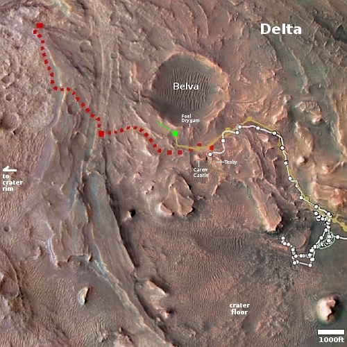
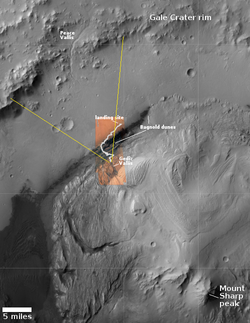
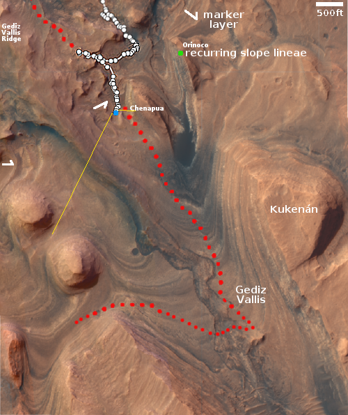
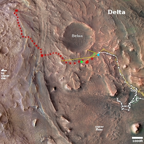
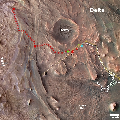
The map to the right shows the context. The green dot marks Ingenuity’s location at the start of the flight. The green line indicates my approximate estimate of its flight path and landing area, which the engineering team has not yet posted. The white dots and line mark Perseverance’s path, with its present location at the area dubbed Tenby where it has obtained its first core sample from the top of the delta.

Sponge terrain on Mars

Sponge terrain on Mars
Click for original image.

Cool image time! The picture to the right, rotated, cropped, reduced, and sharpened to post here, was taken on January 11, 2023 by the high resolution camera on Mars Reconnaissnace Orbiter (MRO).

The scientists labeled this picture “Rocky Terrain.” Though this describes the overall sense of the full image, it fails to capture correctly the nature of this patch of ground at the center of the picture. As you can see, this patch of spongelike surface starts and ends abruptly. It appears that it is a layer on top of the surrounding terrain that has also been eroded aggressively since its placement.

The many craters on its surface seem to have come later, though as the crater size diminishes it becomes harder to separate the craters from the sponge holes. Moreover, some of the larger craters are distorted in shape, as if the impact hit material that was viscous and could flow somewhat.

The overview map below gives some context, but only some.
» Read more

A bubbly cauldron on the surface of Mars

A bubbly cauldron on the surface of Mars
Click for original image.

Cool image time! The picture to the right, rotated, cropped, reduced, and sharpened to post here, was taken on December 20, 2022 by the high resolution camera on Mars Reconnaissance Orbiter (MRO). It shows a strange terrain of craters and mounds, with all the mounds having pits within them like volcanic calderas. In between the surface has a two-toned stippled look, as if two different materials are in the process of mixing.

My immediate impression was that of the bubbly surface of a vat of tomato sauce simmering. Or maybe the vile mixture created by the witches in Shakespeare’s Macbeth, which as they mix they chant:

First witch:
Round about the cauldron go;
In the poison’d entrails throw.
Toad, that under cold stone
Days and nights has thirty-one
Swelter’d venom sleeping got,
Boil thou first i’ the charmed pot.

ALL:
Double, double toil and trouble;
Fire burn, and cauldron bubble.

Of course, this is not a vat of witch’s brew or tomato sauce. It is the surface of the planet Mars, but an alien surface nonetheless.
» Read more

Zhurong: Small polygons on light curved dunes indicate regular atmospheric water interaction

Zhurong's full journey on Mars

A paper published this week in Geophysical Research Letters by the science team for China Zhurong Martian rover has revealed the discovery of small polygon cracks on the surface of the many curved light-colored small dunes found in the region where Zhurong landed, suggesting the possibility of relatively recent water activity between the atmosphere and the dune surfaces.

Those dunes, dubbed transverse aeolian ridges (TARs) by the science team, are the many light curves visible in the labeled Mars Reconnaissance mosaic to the right. The blue arrows indicate Zhurong’s path south from its landing spot at the top and ending near the bottom of the picture after traveling about 1,400 feet.

According to the paper, the TARs were formed by the prevailing winds over many eons, coming first from the north and then from the northwest. The edges of the ridges, being smaller, are pushed ahead quicker, thus creating the curved shape. The polygons were small, never larger than 4 inches in size, with five to six sides. The scientists theorize that they were formed when atmospheric water interacted with the dune crust, causing fractures “due to temperature/moisture changes or deliquescence/dehydration cycling of salts”. This process could be slow or fast, and could actually be occurring in relatively recent times, as the scientists say it requires only a little water in the atmosphere.

More likely however we are seeing evidence of water from the past, from tens of thousands to several million years ago.

Zhurong meanwhile remains in hibernation, and might never come out of that condition. Orbital images indicate that its solar panels are dust-covered, the result of the heavy winter dust storm season. The project team however is hopeful that with time and the arrival of Martian summer the dust will be blown off and they can reactivate the rover. This hope however entirely depends on the arrival of a dust devil acoss the top of Zhurong, a random event that cannot be predicted. With both the Spirit and Opportunity rovers, such events happened regularly, allowing those missions to last years instead of only 90 days. With InSight it never happened, and the lander died after two-plus years on Mars.

Zhurong’s future fate thus remains unknown, but not promising at this moment.

New map of the volcanoes of Venus

Map of Venus' volcanoes
Click for original image.

Using the archival radar data from the Magellan orbiter that circled Venus in the early 1990s, scientists have produced a new map of the volcanoes of Venus.

That map is to the right, and is publicly available for download.

Byrne and Hahn’s new study includes detailed analyses of where volcanoes are, where and how they’re clustered, and how their spatial distributions compare with geophysical properties of the planet such as crustal thickness. Taken together, this work provides the most comprehensive understanding of Venus’ volcanic properties — and perhaps of any world’s volcanism so far … because, although we know a great deal about the volcanoes on Earth that are on land, there are still likely a great many yet to be discovered under the oceans. Lacking oceans of its own, Venus’ entire surface can be viewed with Magellan radar imagery.

Although there are volcanoes across almost the entire surface of Venus, the scientists found relatively fewer volcanoes in the 20-100 km diameter range, which may be a function of magma availability and eruption rate, they surmise.

This new map catalogs about 85,000 volcanoes, but is also considered incomplete because the resolution of the Magellan data makes identifying volcanoes smaller than 1 kilometer impossible. It will require new orbiters to spot these volcanoes.

Looking back from the foothills of Mount Sharp

Panorama looking back across Gale Crater, March 29, 2023
Click for original image.

Overview map
Click for interactive map.

The panorama above, cropped to post here, was taken today by the left navigation camera on the Mars rover Curiosity. It looks back at the rover’s previous travels, though only the terrain traveled in the past few months is visible, the rover having reached this point through the notch to the left of the distinctly dark mesa in the center of the picture. The lower flanks of Mount Sharp the rover traversed to get here are now blocked from view.

Instead, the image provides a spectacular example of the views north from Curiosity’s present position. The overview map to the right provides us the full context of the entire ten-plus year journey since Curiosity landed safely on Mars on August 5, 2012. The white squiggly line indicates the rover’s route. The yellow lines mark the approximate area covered by the panorama. The rim of Gale Crater is about 20-25 miles away.

As you can see, as spectacular as this view is, the journey up Mount Sharp has barely begun. Mount Sharp’s peak is about 18,000 feet high. The rover at this point has only climbed about 4,600 feet from the floor of Gale Crater.

Mars’ largest mountain region

Mars' largest mountain region
Click for original image.

The picture to the right, rotated, cropped, reduced, and enhanced to post here, was taken on September 21, 2015 by the context camera on Mars Reconnaissance Orbiter (MRO). I originally was going to post a high resolution image of some of these mountains, taken on January 1, 2023 that showed some slope streaks, but quickly realized that a wider view of this mountain region was a much more interesting story.

This picture covers an area about 50 by 50 miles. As you can see, it is endless series of random hills ridges and peaks, with only a vague hint of a northeast to southwest alignment. Ground travel through this region would be slow and twisty, immediately reminding me of my many trips to West Virginia, where the hills and valleys are almost as random and never ending.

The overview map below however suggests the scale of this region exceeds West Virginia many times over.
» Read more

Scientists detect water inside lunar samples returned to Earth by Chang’e-5

Chinese scientists have found water molecules trapped within glass beads found within the lunar samples returned to Earth by the lunar lander Chang’e-5.

The team polished and analysed 117 glass beads which were scooped up by China’s Chang’e-5 spacecraft in December 2020 and brought back to Earth. The beads are formed by tiny meteorites that bombard the surface of the Moon, which lacks the protection of an atmosphere. The heat of the impact melts the surface material, which cools into round glass beads around the width of a strand of hair.

…The glass beads may make up around three to five percent of lunar soil, according to the study. A “back of the envelope” calculation suggested that there could be around a third of a trillion tonnes of water inside all the Moon’s glass beads, he added. And it only takes mild heat of around 100 degrees Celsius (210 Fahrenheit) to liberate the water from the beads, Anand said.

According to the paper, the water’s origin might be tied to the solar wind, and might have been implanted in the beads after their impact formation.

If this analysis is correct, it might explain the hydrogen signature found in large parts of the lunar surface, where it is believed water simply couldn’t exist. It also might explain why the first images inside permanently shadowed lunar craters show no obvious ice, only what appear to be ponds of dark dust. The dust might contain these beads, and thus explain the hydrogen signature detected there as well.

A Martian crater with a surface pattern that resembles hanging draperies

A Martian crater with a surface pattern like hanging draperies

Cool image time! The picture to the right, rotated, cropped, reduced, and enhanced to post here, was taken on January 27, 2023 by the high resolution camera on Mars Reconnaissance Orbiter (MRO), and shows what the scientists label a “streak-spoke pattern” inside the crater. To my eye, the pattern more resembles hanging draperies, neatly tied near the top and then pulled apart as they descend to the ground.

This photo was a follow-up to a previous picture by MRO on February 4, 2008, more than seven Martian years ago, to see if there had been any identifiable changes in that time. Both images were taken in springtime, and despite the passage of time, the 2023 image shows no obvious changes from the 2008 photo.

What caused this distinct pattern? The first guess would be the wind, except if so shouldn’t there have been some change over seven Martian years?
» Read more

Curiosity heads to the west of the Hill of Pillows

Panorama on March 27, 2023 (Sol 3781)
Click for full resolution panorama. The original images can be found here, here, here, here, and here.

Overview map
Click for interactive map.

In my previous post on March 11, 2023 showing Curiosity’s spectacular view at that time in the foothills of Mount Sharp, the main question was: Which route will the rover take in the next few weeks? Based on the panorama above, created from five pictures taken by Curiosity’s right navigation camera today, it now appears that the science team has made its decision and will have the rover traverse to the west of what I label the Hill of Pillows.

The overview map to the right gives the context. The blue dot marks Curiosity’s position three days ago, with the yellow lines indicating the approximate area covered by the panorama. The red dotted line shows the planned route going past the Hill of Pillows to the east.

The science team took a careful look at the terrain in both directions, and decided the route to the west was both more gradual and less rough. This set of images by the navigation camera was now taken to better plan the route up in this hollow among its rock-strewn ground.

Make sure you look at the full resolution version of the panorama. You can see on the horizon the high mesas in the south just beginning to appear.

Ancient Martian landslides

Ancient Martian landslides
Click for original image.

Cool image time! The picture to the right, rotated, cropped, reduced, and sharpened to post here, was taken on December 23, 2022 by the high resolution camera on Mars Reconnaissance Orbiter (MRO). The image was labeled “Landslides in Orson Welles Crater” because the full photo shows at least two large and obvious slides, with the biggest shown to the right.

These avalanches are likely ancient because both have craters on them suggesting the material has not moved for a very long time. Yet when both flowed they did so almost like mud, the material moving downhill almost in a single blobby mass. Both have this look, as do many Martian landslides, which I think is why the scientists usually label them mass wasting events.
» Read more

Where the flood lava of two gigantic Martian volcanoes meet

Where the flood lava of two gigantic Martian volcanoes meet
Click for original image.

Today’s cool image illustrates once again the importance of looking not simply at the picture but at the surrounding larger context in order to understand the Martian features within the photograph.

The photo to the left, cropped, reduced, and sharpened to post here, was taken on January 31, 2023 by the high resolution camera on Mars Reconnaissance Orbiter (MRO). The location is at 26 north latitude, so it is in the dry equatorial regions. It shows what appears to be a large Martian flood lava plain, with at least two different flood lava events appearing to flow to the northeast, with the second only partly covering the first.

From this high resolution image it seemed probable that the source of the flow was from the southwest, an assumption that at first glance is strengthened by the overview map below.
» Read more

Confused glaciers in a Martian crater

Confused glaciers in a Martian crater
Click for original image.

Cool image time. The picture to the right, cropped to post here, was taken on February 2, 2023 by the high resolution camera on Mars Reconnaissance Orbiter (MRO), and shows a strangely blobby crater in the northern mid-latitudes where glacial features are frequently found inside craters.

In this case however the glacier seems very confused. As this is in the northern hemisphere, you would expect glacial material to survive on the north-facing southern interior slopes of the crater, where there is year-round less sunlight. The mottled eroded terrain in the south part of the crater floor suggests this. However, the crater also clearly has a terraced glacier on its south-facing northern interior slopes.

Why has the glacial material survived in both places, but not in the center of the crater?

In addition, there is that strange roughly circular feature attached to the south side of the crater. What formed it? Is it a glacier on the plains surrounding the crater? Or are we looking at volcanic material?

This crater is also unique. The crater just to its southwest (partly seen in the cropped image above), is a much more typical glacial-filled mid-latitude crater, its interior material more evenly distributed and its circular rim only slightly distorted.
» Read more

No ice inside permanently shadowed crater near Moon’s south pole?

Marvin crater as seen by Shadowcam
Click for original image.

Overview map

Using a camera on South Korea’s lunar orbiter Danuri, dubbed Shadowcam and designed to look into the permanently shadowed craters at the Moon’s poles, scientists have taken an image that sees into the forever dark region of one such crater.

The picture to the right, released on March 13, 2023 by the Shadowcam science team, is of the crater Marvin, located about 16 miles to the east of the south pole. The pink outline indicates the area that is thought to be permanently shadowed.

The second image to the right provides a wider view of the south pole region, with the craters labeled and outlined by the green lines. The orange lines mark permanently shadowed areas. The white box indicates the approximate area covered by the Shadowcam picture. One of the candidate landing sites for Starship, as part of NASA’s Artemis program, is the eastern rim of Shackleton, essentially at the south pole itself.

Previous data suggests that ice should be found in those permanently shadowed areas, because other orbiters have detected evidence of hydrogen there. The Shadowcam picture above however shows nothing that strongly suggests the presence of ice, unless that darker flat area on the floor of the crater is ice-infused dust. If so however, it is quite ancient and solid, based on the presence of several craters within it.

The press release makes no mention of this question, probably because the scientists are still analyzing the data. This first look however suggests the ice is not there, or is in a form that is going to require a lot of processing to extract the water from it.

A half-mile high Martian cliff on the verge of collapse

A half-mile Martian cliff on the verge of collapse
Click for original image.

Cool image time! The picture to the right, cropped and reduced to post here, was taken on December 24, 2022 by the high resolution camera on Mars Reconnaissance Orbiter (MRO). It shows erosion gullies coming down off a mountain side, just north of a massive cliff that I estimate to be around 2,000 to 3,000 feet high.

Note the north-south-trending cracks. These suggest that this entire half-mile-high cliff face is slumping downward, cracking as it does so. The cracks at the start of the high flat-topped thumb-shaped mesa near the image bottom are especially intriguing. They suggest that this entire mesa might eventually separate and give way.

There is a specific reason this cliff face is slumping, as shown in the overview map below.
» Read more

A verde valley on Mars

A verde valley on Mars
Click for original image.

In the southwest where I live, a valley dubbed “verde” (which means “green” in Spanish) is generally a place with a somewhat persistent river with lots of lush plant life. The Verde Valley in Arizona is the perfect example, with “close to 80% of the valley’s land … national forest.”

On Mars there is also a verde valley, but the name is not descriptive in the least. The picture to the right, rotated, cropped, and reduced to post here, was taken on January 22, 2023 by the high resolution camera on Mars Reconnaissance Orbiter (MRO) and shows one section of the Martian Verde Vallis, draining south to north.

The dark rippled patches inside this shallow canyon are sand dunes. In fact, though MRO has not taken many high resolution images of Verde Vallis, every one shows the valley with further patches of ripple dunes. See for example this image of a section of the valley just a bit farther north.
» Read more

The ubiquitous presence of ice in the Martian mid-latitudes

Ice in the Martian mid-latitudes
Click for original image.

Cool image time! The picture to the right, rotated, cropped, rotated, and sharpened to post here, was taken on November 28, 2022 by the high resolution camera on Mars Reconnaissance Orbiter (MRO). Labeled merely as a “crater with mesa”, it gives us another example of the presence of glacial ice in the mid-latitudes of Mars.

That mesa is what planetary scientists have labeled “concentric crater fill,” a glacial feature found in numerous craters throughout the mid-latitude bands from 30 to 60 degrees latitude. The ground in the terrain surrounding the crater could be also be impregnated with ice, but based on the location as shown in the overview map below, it is just as likely to be lava.

In fact, the location of this particular crater illustrates why concentric crater fill might become the best source of ice for future colonists.
» Read more

Endless ripple dunes in Mars’ third largest impact basin

Ripple dunes in Mars' third biggest impact basin
Click for original image.

Cool image time! The picture to the right, cropped to post here, was taken on November 30, 2022 by the high resolution camera on Mars Reconnaissance Orbiter (MRO).

The section cropped shows only a small portion of the endless ripple dunes seen in this area. The color strip provides us some interesting other details as well as mysteries. The orange indicates dust on the ridges as well as the higher terrain near the center of the picture. The green in the hollows as well as to the east and west suggests coarser materials that have settled in lower elevations. This supposition is reinforced by the orange area near the bottom of the picture where the ripples have mostly dissipated. This is a high spot, and we appear to be looking at a dusty surface. (This impression is clearer in the full image.)

The latitude is high, 48 degrees south, but as far as I know orbital images have not found a lot of ice evidence in this part of Mars.
» Read more

Another study finds evidence of active volcanism on Venus

Changes in volcanic vent on Venus over eight months
Click for original image.

Using archival data from the Magellan spacecraft that orbited Venus in the early 1990s scientists think they have identified an active vent that appeared to change shape based on radar images taken eight months apart.

From the abstract of their paper:

We examine volcanic areas on Venus that were imaged two or three times by Magellan and identify a ~2.2 km2 volcanic vent that changed shape in the eight months between two radar images. Additional volcanic flows downhill from the vent are visible in the second epoch images, though we cannot rule out that they were present but invisible in the first epoch due to differences in imaging geometry. We interpret these results as ongoing volcanic activity on Venus.

This result is different that other research released last month that used Magellan data to identify geological features on Venus most likely to be active. In today’s results the scientists think they have spotted an actual volcanic eruption, as shown in the two images to the right. The image is taken from Figure 2 of the paper, with the changes in the center bottom vent clearly visible.

There is much uncertainty in these results that must be mentioned. The images are not optical but radar, so the scientists had to do a lot of computer processing to get the final result. They also compared this work with computer simulations to help confirm their conclusions.

The results also leave open the question of the total amount of volcanism presently active on Venus. As the scientists note in their conclusion, “With only one changed feature, we cannot determine how common currently active volcanism is on Venus.”

Nonetheless, the research using both new and archival data in the past thirty years is increasingly telling us that there is some active volcanism on Venus, hidden beneath its thick hellish cloudy atmosphere.

Geological evidence of past glacier found in Mars’ dry equatorial regions

Overview map

Scientists have uncovered geological evidence of a past glacier in westernmost end of the giant Martian canyon Valles Marineris, right at the point where it transitions into the complex chaos region dubbed Noctis Labyrinthus. The white dot on the map to the right indicates the location.

The surface feature identified as a “relict glacier” is one of many light-toned deposits (LTDs) found in the region. Typically, LTDs consist mainly of light-colored sulfate salts, but this deposit also shows many of the features of a glacier, including crevasse fields and moraine bands. The glacier is estimated to be 6 kilometers long and up to 4 kilometers wide, with a surface elevation ranging from +1.3 to +1.7 kilometers. This discovery suggests that Mars’ recent history may have been more watery than previously thought, which could have implications for understanding the planet’s habitability.

What we’ve found is not ice, but a salt deposit with the detailed morphologic features of a glacier. What we think happened here is that salt formed on top of a glacier while preserving the shape of the ice below, down to details like crevasse fields and moraine bands,” said Dr. Pascal Lee, a planetary scientist with the SETI Institute and the Mars Institute, and the lead author of the study. [emphasis mine]

You can read the paper here [pdf]. The research specifically suggests that near surface water ice in the dry equatorial regions of Mars could have been there much more recently that previously believed. It also suggests, by the rarity of this discovery, that there is likely almost no near surface ice in the equatorial regions, at present.

Perseverance captures a movie of Ingenuity’s 47th flight on Mars

Ingenuity shortly after take-off on its 47th flight
Click for full movie.

Overview map
Click for interactive map.

During Ingenuity’s 47th flight on Mars on March 9, 2023, one of Perseverance’s high resolution camera’s took rapid-fire images of the helicopter’s take-off and initial flight, from which the science team created a movie.

The overview map to the right provides the context for that movie at the link. The blue dot marks Perserverance’s location, with the yellow lines indicating the approximate area seen in the movie. The smaller green dot and line indicates Ingenuity’s take-off point and part of its flight seen in the movie, with the larger green dot its landing spot. From the press release:

This video shows the dust initially kicked up by the helicopter’s spinning rotors, as well as Ingenuity taking off, hovering, and beginning its 1,444-foot (440-meter) journey to the southwest.

At take-off Ingenuity was 394 feet away from Perseverance.

A Martian crater, ice, and dust devil tracks

A Martian crater, ice, and dust devil tracks
Click for original image.

Cool image time! The picture to the right, rotated, cropped, reduced, and sharpened to post here, was taken on January 2, 2023 by the high resolution camera on Mars Reconnaissance Orbiter (MRO). It is once again a terrain sample image, taken not for any specific research but to fill a gap in the schedule so as to maintain the camera’s proper temperature.

What this picture shows is that even though Mars has a thin atmosphere that produces dust devils, the propagation of dust devils is not uniform across the red planet’s surface. In this picture there are a lot of devil tracks, going in many different directions. Yet few of the many cool images I post from MRO show this number of tracks. In many cases the ground might not be agreeable to leaving tracks, but that cannot be the entire explanation.
» Read more

Splats on Mars!

Splats on Mars
Click for original image.

Cool image time! The picture to the right, cropped and sharpened to post here, was taken on February 3, 2023 by the high resolution camera on Mars Reconnaissance Orbiter (MRO). It shows a number of crater splats of varying sizes. If you look at the full image, you will find several even bigger splats to the north of the one in the picture to the right. You will also see many more similar-sized crater splats to the south.

I cannot provide any confident explanation about what caused these splats, other than to assume that most here are secondary impacts from ejecta thrown out by a larger impact somewhere nearby. I also assume all these small impacts occurred at the same time because they all appear to have hit the ground when it had the same thick liquid consistency, a condition that was probably temporary. Note for example how many of the other craters in the full image do not have this same splattered look.
» Read more

Curiosity looks ahead: Which way to go?

Curiosity's view on March 11, 2023
Click for high resolution version. For original images, go here and here.

Overview map

How about a bonus weekend cool image! The panorama above, created from two pictures taken on March 11, 2023 by the right navigation camera on the Mars rover Curiosity, gives us a wonderful view of the alien Martian terrain that the rover is presently within. It also shows us the dilemma mission planners have in planning the rover’s future travels.

The red dotted line on both the panorama and the overview map to the right indicates the planned route. The yellow lines on the map indicates the approximate area viewed by the panorama. The blue dot marks Curiosity’s present position, where it is presently in the middle of a drilling campaign in the marker layer where it sits.

The plan had been to travel to the east of what I like to call the the hill of pillows (in the middle of the panorama). Yet, it appears from this navigation image that the terrain might be less difficult to the west. Both routes will get the rover to its goal in Gediz Vallis.

I have no idea what the mission planners will decide to do. I am just a tourist going along for the ride, and sharing the journey with my readers. This is the first time any human spacecraft has ever traveled through such mountainous terrain on any planet.

Ingenuity completes 47th flight, scouting ahead of Perseverance

Ingenuity sitting ahead of Perseverance, on the delta
Click for original image.

Overview map
Click for interactive map.

Though the science team has not, as of this posting, added the flight to Ingenuity’s flight log, according to the interactive map showing the positions of both Ingenuity and Perseverance on Mars, the helicopter completed its 47th flight yesterday as planned.

An annotated version of that map is to the right. The larger green dot marks Ingenuity’s new position. The smaller green dot marks its position when the panorama above was taken on February 27, 2023, capturing the helicopter in the distance (as indicated by the arrow). The yellow lines indicate the approximate area covered by that panorama. The blue dot marks Perseverance’s present position.

The flight’s planned distance was to go 1,410 feet to the southwest and “image science targets along the way.” As the helicopter also flew above Perseverance’s planned route, as indicated by the red dotted line, it also provided the rover team information about the ground Perseverance will travel along the way. Since the terrain here is generally not very rough, the information is not critical for route-picking. It might however spot some geological feature that bears a closer look that would not have been noticed by the rover alone.

Ice volcano in the Martian high northern latitudes?

Ice volcano on Mars
Click for original image.

That the Martian surface becomes increasingly icy as one approaches its poles is becoming increasingly evident from orbital images. Today’s cool image provides us another data point.

The picture to the right, rotated, cropped, reduced, and enhanced to post here, was taken on January 4, 2023 by the high resolution camera on Mars Reconnaissance Orbiter (MRO). It is once again another terrain sample image, taken not as part of any particular research project but to fill a gap in the camera’s schedule so as to maintain its temperature. With such pictures, it is hard to predict what will be seen, though the scientists try to find interesting things. In this case the camera team succeeded quite nicely, capturing what appears to me to be a small volcano with two calderas.

This volcano however has almost certainly not spouted lava but mud and water.
» Read more

Cracks in Martian lava

Cracks in Martian lava
Click for original image.

Cool image time! The picture to the right, rotated, cropped, and reduced to post here, was taken on January 25, 2023 by the high resolution camera on Mars Reconnaissance Orbiter (MRO). It was taken not as part of any specific research project, but to fill a gap in MRO’s picture-taking schedule in order to maintain the camera’s temperature. When such pictures need to be taken, the camera team tries to find something of interest in the area to be shot. Sometimes the picture is boring. Sometimes fascinating. Today’s picture I think falls into the latter category.

This is a lava flood plain, as shown in the overview map below. The meandering ridges are likely what geologists call lava dikes, places where lava was extruded out through a fissure. This suggests that the flat flood lava was an older crust, and that there was hot molten lava below it that eventually pushed its way up through cracks in that crust.

This hypothesis however is not certain, as the meandering nature of the ridges does not correspond well with what one would expect from such crustal cracks.
» Read more

Flat-topped mesas in the icy northern lowland plains of Mars

Flat-topped Martian craters
Click for full image.

Cool image time! The picture to the right, cropped and rotated to post here, was taken on December 27, 2022 by the high resolution camera on Mars Reconnaissance Orbiter (MRO), and shows what the scientists have labeled “flat topped hills in Utopia Planitia.”

Utopia Planitia is the largest impact basin on Mars, approximately 2,100 miles across and located in the northern lowland plains.

Orbital evidence strongly suggests it is a region with a lot of near surface ice. The picture to the right reinforces that conclusion, as the entire flat plain surrounding these buttes appears like an ice field. Moreover, the full image shows many craters filled with glacial features, most of which also have softened features, as if with time the ice that impregnates their material has sublimated away.
» Read more

An inactive volcanic vent on Mars

An inactive volcanic vent on Mars
Click for full image.

Cool image time! The picture to the right, rotated, cropped, and reduced to post here, was taken on October 5, 2022 by the high resolution camera on Mars Reconnaissance Orbiter (MRO). Labeled by the science team as “Vents and Lava Flows on Flank of Pavonis Mons,” the section to the right shows the picture’s largest vent. The downhill grade is to the south.

In the full photo you can see that this vent sits on top of a flat mound of hardened lava, all of which flowed from the vent in the distant past. The main flow of course went to the south, out the channel and down the flanks of Pavonis Mons, the middle volcano in the line of three just to the west of Mars’ giant Valles Marineris canyon. The caldera peak of Pavonis Mons is about 35 miles away, and sits at a height of 47,000 feet elevation, far higher than Mount Everest but still only the fourth highest Martian volcano.

In the full picture, the entire surface also generally flows south, except for a crack that goes from northeast to southwest, possibly caused when the mountain flank sagged to the south.
» Read more

Juno captures close-up images of Jupiter’s moon Io

Io as seen by Juno

On March 1, 2023 the Jupiter orbiter Juno passed within 33,000 miles of the gas giant’s moon Io, getting its first close-up images.

Several citizen scientists have processed those images. The photo to the right, cropped and reduced to post here, was created by Andrew R Brown. This particular picture was one of five taken by Juno during the fly-by. Jason Perry processed all five here, with this caption:

Most of the dark spots seen across Io’s surface are the result of volcanic eruptions. These include East Girru, a dark spot that was not seen the last time Io was seen at this resolution during the New Horizons encounter with Jupiter in February 2007. East Girru was undergoing a major eruption at the time but hadn’t had time to produce a new lava flow before the end of the week-long encounter. This small flow field, measuring 3,200 square kilometers (1,390 square miles) in size, may have also been reactivated during an eruption in October 2021, as seen by Juno JIRAM.

Another apparent surface change is at Chors Patera, which has undergone a significant reddening since Galileo last observed it in October 2001. Reddish materials on Io are indicative of the presence of short-chain sulfur and are often associated with high-temperature, silicate volcanism. Additional dark spots near the terminator, the boundary between Io’s day and night sides, are the shadows of tall mountains. The dark spot at middle right in the upper right image may be due a mountain 5500 meters (18,000 feet) tall.

The smallest object resolved in this image is about 22 miles across.

1 9 10 11 12 13 52