JPL requests proposals from the private sector for Mars exploration

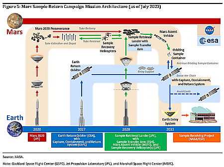
Capitalism in space: JPL, which is the lead agency running NASA’s very troubled Mars Sample Return (MSR) mission, has now issued a request for proposals from the private sector for doing a variety of Mars missions.

NASA’s Jet Propulsion Laboratory issued a request for proposals Jan. 29 for “commercial service studies” for future robotic Mars mission concepts. The studies, with a value of $200,000 or $300,000, would be carried out over 12 weeks. The studies are intended to examine four specific design reference missions to explore commercial opportunities to support Mars exploration: delivery of small payloads of up to 20 kilograms to Mars orbit, delivery of large payloads of up to 1,250 kilograms to Mars orbit, services to provide high-resolution imaging of the Martian surface and communications relay services between Mars and Earth.

Missions to provide imaging or communications from Mars orbit could quite easily be provided by numerous private companies. Delivering payloads to the Martian service is exactly what SpaceX proposes with Starship, and is also what several lunar lander companies have now been doing.

Up until now, JPL has always built everything in-house, or if it didn’t it designed and managed everything very closely. The result with MSR is a project that is now poorly managed, vastly over budget and behind schedule, and very likely to fail. This proposal suggests JPL is now recognizing that private enterprise might be able to do it better, as NASA has now proven with its shift from being the builder to becoming merely a customer.

If so, this proposal might be indicating the first step at JPL and NASA in imposing a major change in MSR itself, coming as it does just days after the release of an inspector general report about that project’s many problems.

Ingenuity’s final resting place on Mars

Panorama showing Ingenuity in Jezero Crater
Click for original image.

Overview map
Click for interactive map.

Time for one last cool image of Ingenuity. The picture above, cropped, reduced, and annotated to post here, was created from a mosaic of 67 images taken on February 21, 2024 by the high resolution camera on the Mars rover Perseverance. The white rectangle marks the approximate area covered by the image below, a mosaic of seven pictures taken on February 24, 2024 by Perseverance’s Remote Microscopic Imager camera, normally used to take very close images of nearby rocks but repurposed here to provide a close up of Ingenuity about 1,365 feet away, inside Neretva Vallis. Ingenuity is on the right, and the speck on the left is the section of the rotor blade that broke off and was apparently flung about 49 feet away.

On the overview map to the right, the blue dot marks Perseverance’s position, the green dot Ingenuity’s, and the yellow lines mark the approximate area covered by the panorama above. The red dotted line is Perseverance’s planned route in the coming months.

Close-up of Ingenuity and broken rotor blade
Click for original image.

A Martian cliff of ash, flushed by wind

A Martian cliff of ash flushed by wind
Click for original image.

Cool image time! The picture to the right, rotated, cropped, reduced, and sharpened to post here, was taken on December 27, 2023 by the high resolution camera on Mars Reconnaissance Orbiter (MRO). Described merely as an “exposed scarp” by the science team, this cliff edge is actually much more.

First some basic details. The elevation drop from the plateau down to the base of this cliff is about a thousand feet. The material that forms this plateau, scarp, and its base is all volcanic ash. The thicker sections of ash has caused its lower levels to compress, harden into a kind of sandstone. Near the surface however it is more friable, and like sandstone can break apart somewhat more easily.

The prevailing winds at this site are generally blowing to the south, but beginning to turn to the east, which explains the northwest to southeast orientation of the features.

The best analogy I can come up with to explain the erosion of this scarp is as follows: Imagine a deposit of dry mud a few inches thick on pavement. Take a leaf blower and blow at it hard, always in one direction. Eventually the outer edge will break up and blow away, leaving a sharp edge, that will also retreat with time as the wind continues to blow.

Here the winds are eroding that cliff, causing periodic avalanches which dissolve into sand that then blows away, leaving no debris pile at the base of the cliff. The ridges indicate harder material, that breaks away last, which is why there are some ridgelines extending outward from the scarp in line with these ridges. At the same time, these ridges of harder ash still break up with time, as some are cut off suddenly at the cliff edge.
» Read more

Inspector General: Mars Sample Return mission in big trouble

The present plan for Mars Sample Return

Though the audit published today [pdf] by NASA’s inspector general of the NASA/ESA Mars Sample Return mission partnership tries to couch its language positively, the conclusion one reaches by reading the report is that the project is a mess and will almost certainly not fly when scheduled in 2029, and might even get delayed so much that the Perseverance rover on Mars — an essential component of the mission plan — might no longer be operational at that time.

First the budget wildly out of control.

The trajectory of the MSR Program’s life-cycle cost estimate, which has grown from $2.5 to $3 billion in July 2020, to $6.2 billion at KDP-B in September 2022, to an unofficial estimate of $7.4 billion as of June 2023 raises questions about the affordability of the Program.

In addition, the audit noted that this is not the end, and that based on another independent review the budget could balloon to $8 to $11 billion before all is said and done. (I will predict that as presently designed, that budget will likely reach $15 billion.)
» Read more

A recent volcanic eruption on Mars?

A recent volcanic eruption on Mars?
Click for original image.

Cool image time! The picture to the right, cropped, reduced, and sharpened to post here, was taken on December 16, 2023 by the high resolution camera on Mars Reconnaissance Orbiter (MRO). The science team labels the two darkened patches in the picture “plume-like features,” suggesting that the dark material was eruptive material thrown out from the depressions in a volcanic venting, that then settled on the nearby surrounding terrain.

Is that a correct interpretation? It is certainly strengthened by a different feature located about 550 miles to the northwest that looks almost the same. There, researchers theorize that the dark material surrounding a surface fissure was caused by a small volcanic event that occurred somewhere between 50,000 to 210,000 years ago. For that other location, scientists concluded as follows:

After careful comparison of this symmetrical dark feature with other dark wind-caused streaks in this region, the scientists concluded that it was not caused by wind, but is the remains of a relatively recent volcanic eruption that laid down a thin layer of material only about one foot thick.

» Read more

Ingenuity broke off one blade entirely

Ingenuity with missing blade
Click for original image.

Images using a camera on Perseverance originally designed to look closely at rocks nearby but was found capable of doing distant photography (by engineers running the rover Curiosity), Perseverance has obtained the first good close-up picture of Ingenuity since its last flight, and found that one half of one propeller blade apparently broke off during or at the end of its last flight.

That image is to the right, cropped and sharpened to post here. It was taken on February 25, 2024 by Perseverance’s Supercam camera. A second Supercam image spotted the broken blade about fifty feet away, on the sand.

Why the blade broke off remains unknown. You can see from the tracks on the ground that Ingenuity jumped downhill and sideways after landing, but if the blade had hit the ground while spinning that jump would probably have been more violent. The pictures instead suggest it broke off not from contact with something else but because it broke on its own.

The Ingenuity engineers will of course do some very careful analysis of both pictures, and possibly determine better what happened.

Mars’ flaky rocks

Mars' flaky rocks
Click for original image.

Cool image time! The picture to the right, cropped, reduced, and sharpened to post here, was taken on February 21, 2024 by the high resolution camera on the Mars rover Curiosity. It once again shows us a very typical many layered rock that the rover has seen routinely in Gale Crater and in the foothills of Mount Sharp.

The long flake tells us many things. First, Mars’ one-third Earth gravity, thin atmosphere, and lack of life allows such flakes to survive. On Earth not only would wind and rain break such delicate forms, plant life would eat away at it as well.

Second, the many thin layers tell us again that Mars’ geological history comprises many cycles and geological events, each of which placed another layer down. The many layers here could actually be evidence of year-by-year events, much like tree-rings detail the drought conditions yearly on Earth.

It will take study on Mars however to find out. These image only tantalize. They cannot give answers.

Frozen lava rapids on Mars

Frozen lava rapids on Mars
Click for original image.

Cool image time! The picture to the right, rotated, cropped, reduced, and sharpened to post here, was taken on October 6, 2023 by the high resolution camera on Mars Reconnaissance Orbiter (MRO), and shows a spot on Mars where lava was squeezed between and around some small peaks as it flowed quickly south, flooding all the low areas in this landscape.

The science team describes the features in the full image as “streamlined”, a description that is literally accurate. As this “stream” of lava rushed past, it “lined” the higher terrain, carving it into tear-dropped shapes.

In the color strip, note the blueish spots at the northern base of the 400-foot-high hill. According to the science team’s explanation [pdf] of the colors in MRO images, “Frost and ice are also relatively blue, but bright, and often concentrated at the poles or on pole-facing slopes.” The picture was taken in summer, so if these bright spots are frost or ice, it suggests they are well shaded from sunlight in those north-facing alcoves. This location is only 9 degrees north of the equator, so finding any near surface ice here is highly unlikely. That frost might exist however is intriguing, to say the least.
» Read more

Curiosity’s view of Gale Crater from its new heights on Mount Sharp

Low resolution version of panorama
Click for full resolution version of panorama. For the original images, go here, here, and here.

Overview map

Cool image time! The panorama above was created from three pictures taken on Februay 13, 2024 by the left navigation camera on the Mars rover Curiosity (available here, here, and here). It looks to the north, across Gale Crater and its nearest rim, about twenty miles away. The red dotted line indicates the approximate route Curiosity took to get to this point. The yellow lines on the overview map to the right show the approximate area covered by the panorama.

The images were part of the routine mosaics created by both the left and right navigation cameras for helping engineers plot the rover’s future travels. The pictures that look back at the far rim however also provide important atmospheric data. In this case, the haze tells the scientists how much dust is in the atmosphere. It is presently winter in Gale Crater, which also corresponds to the dust storm season. Thus, the view is very hazy.

Curiosity will likely remain at this location for several more weeks, as the science team is about to begin another drilling campaign. Note the large dark area on the cliff face on the right that is also level with the terrace where Curiosity presently sits. The scientists want to get core data of this layer, and they think they are at a good spot to do so.

Martian gullies caused by glacial and water erosion

A gully on the north rim of Niquero Crater
Click for original image.

Cool image time! The picture to the right, rotated, cropped, reduced, and sharpened to post here, was taken on December 23, 2023 by the high resolution camera on Mars Reconnaissance Orbiter (MRO).

The image shows us the north interior rim of 7-mile-wide Niquero Crater on Mars. From the high to the low points the elevation difference is about 2,500 feet, with a steep downhill slope averaging about 18 degrees. The terrain appears to show several avalanche collapses that pushed lower material out of the way, though at the bottom where that material has been pushed aside there is no obvious large debris pile.

The science team labels this image simply “volatiles and gullies”, a label that carries a host of significant information. These gullies, which were among the earliest found by Mars Global Surveyor in the late 1990s, were the first evidence that the surface of Mars had a lot of near surface ice. It is for this reason that this relatively small crater on Mars has a name. Most craters this small remain unnamed, but the gullies on Niquero’s north slopes required more study, and thus the crater was given a name.

Subsequent orbital imagery has now shown that craters like Niquero, located in latitudes higher than 30 degrees, quite often are filled with glacial debris. In fact, the material that these avalanches pushed aside at the base of the slope is that glacial material, protected by a thin layer of dust and debris. The avalanche essentially disturbed that protected layer, and thus the debris pile (made up mostly of ice) sublimated away when warmed by sunlight. Thus. no big debris pile.

The gullies tend to be on the pole-facing slopes. Scientists believe they are the remnant evidence of ancient glaciers that grew on these slopes because they were protected from sunlight. In subsequent eons, when the climate on Mars changed, those glaciers collapsed, leaving behind the gullies we see now.
» Read more

India proposes to send its own helicopter to Mars

India has now considering adding its own helicopter to its next Mars mission, dubbed the Martian Boundary Layer Explorer (Marble).

While ISRO’s rotorcraft is still in the conceptual stage, the agency envisions a drone that can fly as high as 100 meters in the thin Martian air. Along with the Marble instrument suite, the drone is expected to carry various sensors, including temperature, humidity, pressure, wind speed, electric field, trace species, and dust sensors.

Whether this mission will include a lander, rover, or orbiter as well is very unclear, which suggests strongly the entire mission profile is presently very much undecided as yet.

Alternating dark and light terraces inside Valles Marineris

Overview map

Alternating dark and light layered terraces in Valles Marineris
Click for original image.

Cool image time! The picture to the right, cropped and enhanced to post here, was taken on October 9, 2023 by the high resolution camera on Mars Reconnaissance Orbiter (MRO), and shows what appear to be the somewhat typical terrain at this location, in a part of the giant Martian canyon Valles Marineris dubbed West Candor Chasma. For example, I featured similar swirls in August 2022 at a place only about six miles to the east, that spot indicated by the green dot on the overview map above. The white dot marks the location of today’s image.

So, what are we looking at? The elevation drop from the high and low points is only about 180 feet, but in that short distance it appears there are more than two dozen visible layers, and those layers form terraces that alternate between bright and dark material.

The shape of the swirls also suggest that a flow of some kind, either water, ice, or wind, moved from the northwest to the southeast, carving these terraces as it descended the stair steps downward. It is also just as likely that we are seeing repeated lava flows going downhill to the southeast, each even laying another layer on top of the preceeding one. And it is also possible that we are looking at a combination of both.

The alternating dark and light layers suggest that each dark layer was an event that put down dark material, such as volcanic dust, that was subsequently covered with light material, with this process repeating itself many times over the eons.

That the floor of this part of Valles Marineris is uniquely covered in this manner is in itself intriguing. Why here, and not elsewhere within the canyon?

The alien surface of Mars

The alien surface of Gediz Vallis
Click for original image.

Overview map
Click for interactive map.

Cool image time! The picture above, brightened slightly to post here, was taken on February 15, 2024 by the right navigation camera on the Mars rover Curiosity. It looks east at the looming cliff face of the mountain Kukenan that the rover has been traveling beside for the last six months. On the overview map to the right the yellow lines indicate roughly the area covered by this picture. The blue dot marks Curiosity’s present position, while the green dot marks its position on February 5, 2024. As you can see, the rover is making slow but steady progress uphill into Gediz Vallis.

This image illustrates the alien landscape of Mars quite beautifully. First, there is absolutely no life in this picture. On Earth you would be hard pressed to find any spot on the surface that doesn’t have at least some plant life.

Second, there is the rocky layered nature of this mountain. When the Curiosity science team first announced its future route plans (the red dotted line) to drive into this canyon back in 2019, the orbital images of these layers from Mars Reconnaissance Orbiter (MRO) had suggested the terrain here would be reminiscent of The Wave in northern Arizona, a smooth series of curved layers smoothed nicely over time by the wind.

As you can see, there is no smoothness here. Instead, every single layer here is infused with broken rock, suggesting that each layer is structurally weak. As erosion exposes each, the layer breaks up, crumbling into the chaos in this picture. The curved nature of the terrain at the bottom of the picture however does suggest that some sort of flow once percolated down this canyon, either liquid water or glacial ice, carving the layers into this curved floor.

The shoreline of a Martian lava sea

The shoreline of a Martian lava sea
Click for original image.

Cool image time! The picture to the right, cropped, reduced, and enhanced to post here, was taken on October 2, 2023 by the high resolution camera on Mars Reconnaissance Orbiter (MRO).

The science team labeled this a “lava margin.” The darker material on the right is apparently a newer deposit of lava, flowing on top of the lighter lava on the left. The newer deposit is only about three feet thick, so it had to have flowed fast almost like water to cover this large area with such a thin layer before freezing. Even so, this new lava layer has a roughness greater than the older layer below it. Either the older layer is smoother because of erosion from wind over eons, or the lava in these two layers was comprised of slightly different materials that froze with different textures.

The small ridges appear to be wrinkle ridges, created when material shrinks as it freezes.

This margin marks the edge of a very large flood lava event, as illustrated by the overview map below.
» Read more

Spiders on the rim of a Martian crater

Spiders on the rim of a Martian crater
Click for original image.

Cool image time! The picture to the right, cropped to post here, was taken on December 29, 2023 by the high resolution camera on Mars Reconnaissance Orbiter (MRO). It shows strange spidery formations on the rim of a 17-mile-wide crater about 500 miles from the south pole of Mars.

Scientists think these spider features are formed due to the seasonal cycle on Mars. In the winter at the poles the carbon dioxide in the atmosphere falls as snow in the polar regions, creating a thin dry ice mantle that covers everything. When spring arrives, sunlight goes through the clear mantle to heat its base, causing that dry ice to sublimate into gas that is trapped below the mantle. Eventually that mantle cracks at a weak point and the gas escapes, spewing dark dust on its top. By summer the mantle is entirely gone, and the black splotches disappear as they blend back into the same colored ground.

At the south pole the ground appears to be firmer and more structurally sound than at the north pole. The trapped gas appears to travel upward along the same tributary paths to the same escape points each year, thus carving these spidery features that are permanent features.
» Read more

One instrument on Perseverance has a problem

One of the instruments on the Mars rover Perseverance appears to have a problem that is preventing it from using its laser to collect spectroscopic data of the nearby Martian surface.

Data and imagery from NASA’s Perseverance Mars rover indicate one of two covers that keep dust from accumulating on the optics of the SHERLOC instrument remains partially open. In this position, the cover interferes with science data collection operations. Mounted on the rover’s robotic arm, SHERLOC uses cameras, a spectrometer, and a laser to search for organic compounds and minerals that have been altered in watery environments and may be signs of past microbial life.

The mission determined on Jan. 6 that the cover was oriented in such a position that some of its operation modes could not successfully operate. An engineering team has been investigating to determine the root cause and possible solutions. Recently, the cover partially opened. To better understand the behavior of the cover’s motor, the team has been sending commands to the instrument that alter the amount of power being fed to it.

Should this troubleshooting fail to fix the dust cover, the rover’s other instruments can still compensate, gathering spectroscopy in other ways. Losing SHERLOC however will still reduce the data that Perseverance can obtain.

German-built mini-rover for Japanese Phobos mission shipped to Japan

A German-built mini-rover, dubbed Idefix, has now been shipped to Japan to intergrate it as a secondary payload on that country’s MMX mission to the Martian moon Phobos.

The rover itself weighs 25 kilograms (55 pounds), is 51 centimeters long (20 inches), and is designed to explore up to 100 meters of Phobos’ surface. During one of MMX’s closest approaches to Phobos, the rover will be released at an altitude between 40 and 100 meters above the surface and touch down on Phobos. The drop utilizes the low gravity of Phobos, which will allow IDEFIX to just fall onto the surface, roll, and then raise itself to prepare for the roughly three-month-long mission. The gravity of Phobos is only roughly 1/1000th of the gravity of Earth, which can be attributed to the moon’s small size. Phobos only has a diameter of approximately 27 kilometers.

“Thanks to the low gravity, IDEFIX will need between 60 to 80 seconds from release to the touchdown on Phobos. The impact will be with less than one meter per second,” explained Professor Markus Grebenstein, who is DLR’s project lead for IDEFIX, in an interview with NSF.

If all goes right, the rover’s mission will last at least 100 days. MMX itself it scheduled to reach Phobos in 2029.

Meanwhile, scientists used one of the Perseverance’s high resolution cameras to capture another partial eclipse of the Sun by Phobos. This is not the first such Phobos eclipse that Perseverance has photographed (see for example here and here), but it is neat nonetheless.

Martian dunes with strange splotches

Martian dunes with splotches

Cool image time! The picture to the right, cropped to post here, was taken on December 20, 2023 by the high resolution camera on Mars Reconnaissance Orbiter (MRO). It shows what the science team labels as “Dunes with Blotches.”

The blotches, or as I call them splotches, are the round dark patches on dunes themselves. Though their darkness is reminiscent of the dark patches that appear as spider features in the south polar regions of Mars, there are problems linking the two. The spiders form when the winter mantle of dry ice that falls as snow begins to weaken when the Sun reappears in the spring. Sunlight travels through the clear dry ice to warm the base of the mantle, causing it to sublimate into carbon dioxide gas. That gas however is trapped at the base, and only escapes when the thin mantle cracks at weak points. As the gas puffs out it carries with it dust, which leaves dark patches on the surface that disappear when the mantle disappears entirely by summer.

In the southern hemisphere at the poles the ground is somewhat stable, so the trapped gas appears to travel along the same paths each year to the same weak spots. This in turn causes it to carve spidery patterns in the ground, like river tributaries, except here the tributaries of gas flow uphill to their escape point. At the north pole the ground is not as stable. Instead we have many dunes, so that the dry ice mantle sublimates away at different places each year. There is no chance to form such spider patterns over time.

Making these splotches more puzzling is the season. This picture was taken in the winter, at a time one would think no dry ice is sublimating away.
» Read more

More hiking possibilities on Mars!

More hiking possibilities on Mars
Click for original image.

Cool image time! The picture to the right, rotated, cropped, reduced, and sharpened to post here, was taken on September 27, 2023 by the high resolution camera on Mars Reconniassance Orbiter (MRO). Dubbed a “terrain sample” by the science team, this picture was likely chosen not as part of any specific research project but to fill a gap in the camera schedule so as to maintain that camera’s proper temperature.

When the team needs to do this they try to pick interesting targets. In this case the location is the region of many many parallel north-south fissures that extend for more than 800 miles south of the giant but relative flat shield volcano Alba Mons. These fissures are grabens, cracks formed when underground pressure pushed the ground up and caused it to spread and crack.

What attracted me to this picture is the ridgeline. It struck me as a wonderful place to hike. I have even indicated in red the likely route any trail-maker would pick to go from the valley below up onto the ridge, and then along its knifelike edge to the south. The height of the cliff down to the east valley averages about six hundred feet, guaranteeing beautiful scenery the entire length.
» Read more

A small Martian volcano?

A small Martian volcano?
Click for original image.

Cool image time! The picture to the right, cropped, reduced, and sharpened to post here, was taken on December 21, 2023 by the high resolution camera on Mars Reconnaissance Orbiter (MRO). The science team labeled it a “fresh crater”, but that description I think is misleading, as it implies a recent impact.

The crater does not look like a fresh impact crater to me. Such things on Mars usually appear very dark, as the impact dredges up dark material. This crater is not dark. More significant is the crater itself. The small 300-foot-wide inner crater, surrounded by a circular plateau and all sitting inside the larger 1,200-foot-wide crater is completely unique compared to any impact crater I have ever seen. Impacts in soft material, such as ice-impregnated ground, can cause concentric ripple rings, but they don’t look like this.

Instead, this crater more resembles the caldera of a volcano, where subsequent eruptions can produce overlapping depressions at the volcano peak. (See for example this picture of Olympus Mons.)

Moreover, the crater sits on top of a peak approximately 300 feet high. While impacts in ice-impregnated ground on Mars can produce splash aprons as seen here, the crater usually sits at about the same elevation as the surrounding terrain, not at the top of a peak. This peak suggests the apron was forned not by a splash but repeated flows coming down from the top.
» Read more

JPL to lay off 8% of its work force plus 40 contractors

Claiming the uncertainty of its federal budget allocation due to Congress’s inability to pass a new budget, the Jet Propulsion Lab (JPL) earlier today announced it was laying off 8% of its work force, 530 employees, plus 40 contractors.

In a memo to JPL staff Feb. 6, [director Laurie] Leshin said that a lack of a final 2024 appropriations bill — NASA is operating on a CR [continuing resolution] that runs until March 8 — forced the layoffs after taking other measures such as a hiring freeze and reductions in MSR [Mars Sample Return] contracts and other spending, as well as the earlier contractor layoffs. “So in the absence of an appropriation, and as much as we wish we didn’t need to take this action, we must now move forward to protect against even deeper cuts later were we to wait,” she wrote.

Uncertainty about how the Mars Sample Return project should be designed and built had caused Congress to express doubts about the project, with the Senate suggesting major cuts. NASA responded by loudly pausing the project and suggesting its own cuts. JPL has now followed up with these layoffs. Both have I think done so as a lobbying tactic, and as expected in this game of budget lobbying these actions have caused many legislators to scream in horror: “We really didn’t mean it! We really don’t want to cut anything!”

Expect our bankrupt Congress to fold and provide NASA and JPL the blank check it wants to fly a Mars mission that will cost billions, be years late, and likely be beaten to Mars by SpaceX’s Starship (which could do the job for a tenth the cost).

Curiosity’s damaged wheels continue to appear stable despite the rough Martian terrain

A new look at Curiosity's worst wheel
To see the original images, go here and here.

The rover Curiosity on Mars has for more than two years been traveling across a very rocky and rough terrain as it climbs higher and higher on Mount Sharp inside Gale Crater. Since the rover’s wheels experienced far more damage than expected early in its mission, when it was on the floor of the crater where the terrain was not as severe, engineers have adopted a whole range of techniques to try to reduce any further damage.

First, they increased the safety margins on the software that guides Curiosity. It picks its way very carefully through the rocks, and stops immediately if it finds itself crossing terrain that is too rough.

Second, the science team does a photo survey of the wheels after every kilometer of travel. The two pictures to the right compare the damage on the rover’s most damaged wheel, with an image from the previous survey on top and the most recent image, taken yesterday, on the bottom. I have numbered the same treads, called grousers, in the two images to make it easier to compare them.

As you can see, it does not appear as if the damage has increased in the 210 sols or seven months of travel since the last survey. This wheel looks bad, but it is the worst wheel on the rover, and the strategies that the engineering team adopted years ago to reduce further damage continue to work, even as Curiosity traverses some very rough ground.

The software requires the rover to travel shorter distances in each drive when the ground is this rough, but the consequence is that it will last much longer, and thus have a better chance of reaching higher elevations on Mount Sharp.

Perseverance snaps its first picture of grounded Ingenuity

Overview map
Click for interactive map.

Ingenuity on dune, as seen by Perseverance on February 4, 2024
Click for original image.

Perseverance on February 4, 2024 finally moved into a position where it was close enough to take its first picture of the now grounded Ingenuity helicopter. That picture, cropped, reduced, and enhanced to post here, is to the right, taken by the rover’s left high resolution camera. You can see Ingenuity sitting on the slope of a dune near the upper right.

The overview map above provides the context. The green dot marks Ingenuity’s final resting spot. The blue dot marks Perseverance’s present location, with the yellow lines indicating approximately the area covered by the photo.

Whether the rover is now close enough to get good imagery for a final engineering test of Ingenuity — where its rotors will be rotated and shifted slowly to determine the extent of the propeller damage — is not clear. Perseverance could move much closer, but its science team might not want to cross these dunes out of fear the rover would get stuck. They might move forward a few more feet, to the top of the south bank of Neretva Vallis, before doing that test.

A spot where the surface of Mars cracked

The spot where Mars cracked
Click for original image.

Cool image time! The picture to the right, rotated, cropped, reduced, and sharpened to post here, was taken on September 14, 2023 by the high resolution camera on Mars Reconnaissance Orbiter (MRO). It shows a small section of the Cerberus Fossae cracks, a parallel series of cracks that stretch more than 700 miles across the volcanic plains of Mars.

These cracks formed when the ground spread apart, creating a void in which the surface collapsed. You can see this process illustrated quite clearly by the crater in the lower right, as indicated by the arrow. The crater had existed prior to the crack. When the ground split and collapsed, only the northeast quadrant of the crater was destroyed.

These cracks might also have been the source of Mars’ most recent large volcanic event, as shown by the overview map below.
» Read more

Curiosity looks ahead at very rough terrain higher on Mount Sharp

Panorama on Sol 4086, February 3, 2024
Click for full image.

The rough terrain higher on Mount Sharp
Click for original image.

Cool image time! The picture to the right, reduced and enhanced to post here, was taken on February 3, 2024 by the high resolution camera on the Mars rover Curiosity. The area it covers is indicated by the rectangle on the panorama above, which has been cropped, reduced, and enhanced to post here. That panorama was created from 46 photos taken by the rover’s right navigation camera on that same day.

Those rough small peaks are higher on Mount Sharp, though far below its summit. The summit itself is not visible, and in fact has never been visible to Curiosity since it landed on Mars in August 2012. The peak is about 26 miles to the south and about 16,000 feet higher up, with much of the mountain in the way.

These small, rough peaks are in an area that the rover will likely never go, as shown in the overview map below.
» Read more

One last engineering test planned for Ingenuity

Engineers plan to do one last engineering test with Ingenuity, slowly rotate its propellers while collecting imagery, likely from both the helicopter and Perseverance.

Teddy Tzanetos, Ingenuity Project Manager, said that NASA and JPL still aren’t sure what caused the damage to Ingenuity’s blades; it remains unclear whether the helicopter’s power dipped during landing, causing unwanted ground contact, or if it accidentally struck the ground to cause a “brownout.”

Tzanetos added that NASA and the Jet Propulsion Laboratory (JPL) will slowly rotate the helicopter’s blades and “wiggle” them, or adjust their angle, while collecting video in order to allow the team to determine the extent of Ingenuity’s damage. However, Tzanetos said that no matter what such imaging will show, the dual-rotor drone has flown its last flight and will soon end its mission.

This test will likely not occur until Perseverance gets into a position where it can film the test also. The helicopter’s cameras look downward, so all it will be able to photograph is the shadow of those blades as they move. Perseverance can look directly at it, and if it gets into a position slightly higher than Ingenuity it can get a good viewing angle down at the blades.

At the moment the rover is about a thousand feet to the east, though steadily working its way towards it.

Have these Martian dunes changed in sixteen years?

Comparing two MRO images taken 16 years apart
Click here and here for the original images.

Overview map

Cool image time! The two pictures above, both rotated, cropped, reduced, and enhanced to match and to post here, were taken by the high resolution camera on Mars Reconnaissance Orbiter (MRO) sixteen years apart. The first, on the left, was taken on February 23, 2007, while the second, on the right, was taken on November 1, 2023.

What drew me to both images was the label for the second: “Dune Change in Arabia Region Crater.” To find out if this image had revealed any changes in the dunes I went back and found the earliest MRO picture of this location, and sized and enhanced the dunes in both to match.

Do you see any changes? I don’t. However, that really means nothing. These are not the highest resolution versions that MRO obtains, and a very careful comparison of those best images might detect more subtle changes than our eyes can perceive in the versions above. Also, there might be brightness changes that require careful software analysis.

The white dot on the overview map to the right marks the location, in Arabia Terra, the largest transition region on Mars between the northern lowland plains and the southern cratered highlands. The inset shows the half filled crater in which these dunes sit. The grayed area on the floor of the crater marks the entire dune field, extending eastward to the crater rim from this one spot, indicated by the black dot.

It is likely that the dust is blown into this crater and gets trapped there. Whether the dunes move or change is not clear, though if they do the changes are small, even after almost two decades. Instead, the two pictures suggest these dunes have hardened into a form of sandstone, that can be eroded over time by the wind, but only very very slowly.

A plateau of friable rock on Mars

A plateau of friable rock on Mars
Click for original image.

Cool image time! The picture to the right, rotated, cropped, reduced, and sharpened to post here, was taken on September 13, 2023 by the high resolution camera on Mars Reconnaissance Orbiter (MRO).

The science team labels this “Friable Outcrops in Aeolis Dorsa.” What we are looking at is the northeasternmost tip of a 30-mile long plateau that marks the northern edge of Mars southern cratered highlands. For most of its length the top of that plateau is relatively smooth, broken by some vague surface features and a few scattered craters (suggesting it is relatively young). However, as you approach the plateau’s edges and especially that northeastern tip the surface begins to break up into the rough terrain shown to the right. It appears that the prevailing winds from the north are scouring the soft topsoil here and causing it to wear away, leaving behind those innumerable small ridges, almost all of which are oriented from north-to-south.

But why is the topsoil here soft and so easily scoured?
» Read more

Ingenuity’s final resting site on Mars

Overview map
Click for interactive map.

Ingenuity's damaged propeller
Click for orignal image.

The photo to the right was downloaded from Ingenuity today, and looks downward at the ground below the helicopter, showing the shadow of one of its propellers, with the damage at its tip indicated by the arrow.

It is this damage that forced NASA management to retire the helicopter yesterday. With the tip of one of Ingenuity’s two propellers damaged, the helicopter simply can no longer fly reliably, or at all.

The green dot on the map above shows Ingenuity’s final resting spot. The blue dot shows Perseverance’s present position. Perseverance will surely at some point approach Ingenuity closely to get better pictures of the damage to help engineers better figure out what happened and why. For example, did the propellor simply break during flight? And if so, why?

I freely admit that my optimistic speculations last week were wrong, that Ingenuity was merely having communications issues with Perseverance. I also suspect the Ingenuity engineers were hoping the same thing, and were far more disappointed than I to discover otherwise.

Ingenuity’s mission on Mars is over

Ingenuity takes off!
Ingenuity takes off on its first flight, April 19, 2021.
For full images go here and here.

NASA today announced that Ingenuity’s mission on Mars has now ended due to damage sustained to one of its propellers during its 72nd flight.

While the helicopter remains upright and in communication with ground controllers, imagery of its Jan. 18 flight sent to Earth this week indicates one or more of its rotor blades sustained damage during landing, and it is no longer capable of flight.

Ingenuity’s engineering mission was designed initially to simply prove that air-powered flight in Mars’ thin atmosphere was possible by a test program of four flights over 30 days. It worked so well that it just kept going and going. During its almost three years of operation on Mars, the helicopter completed 72 flights, for a total air time of about 128 minuntes. It flew a total of about eleven miles, reaching a maximum speed of over 22 miles per hour and a top altitude of about 79 feet. On its 69th flight it traveled a record 2,315 feet, almost a half mile.

All future Mars missions have been changed forever by the success of Ingenuity and its designers and engineers. For example, there are already hints of a helicopter mission to Mars’ giant canyon Valles Marineris. In addition, NASA redesigned its Mars Sample Return Mission to include helicopters based on what it learned from Ingenuity.

More important, Ingenuity suggests that when settlers finally colonize the red planet, it is very possible that air travel will start out more important than ground transport. In fact, long distance roads might never be built, for any number of reasons, because air travel will be available from the beginning.

1 2 3 4 74