Changes on Comet 67P/C-G

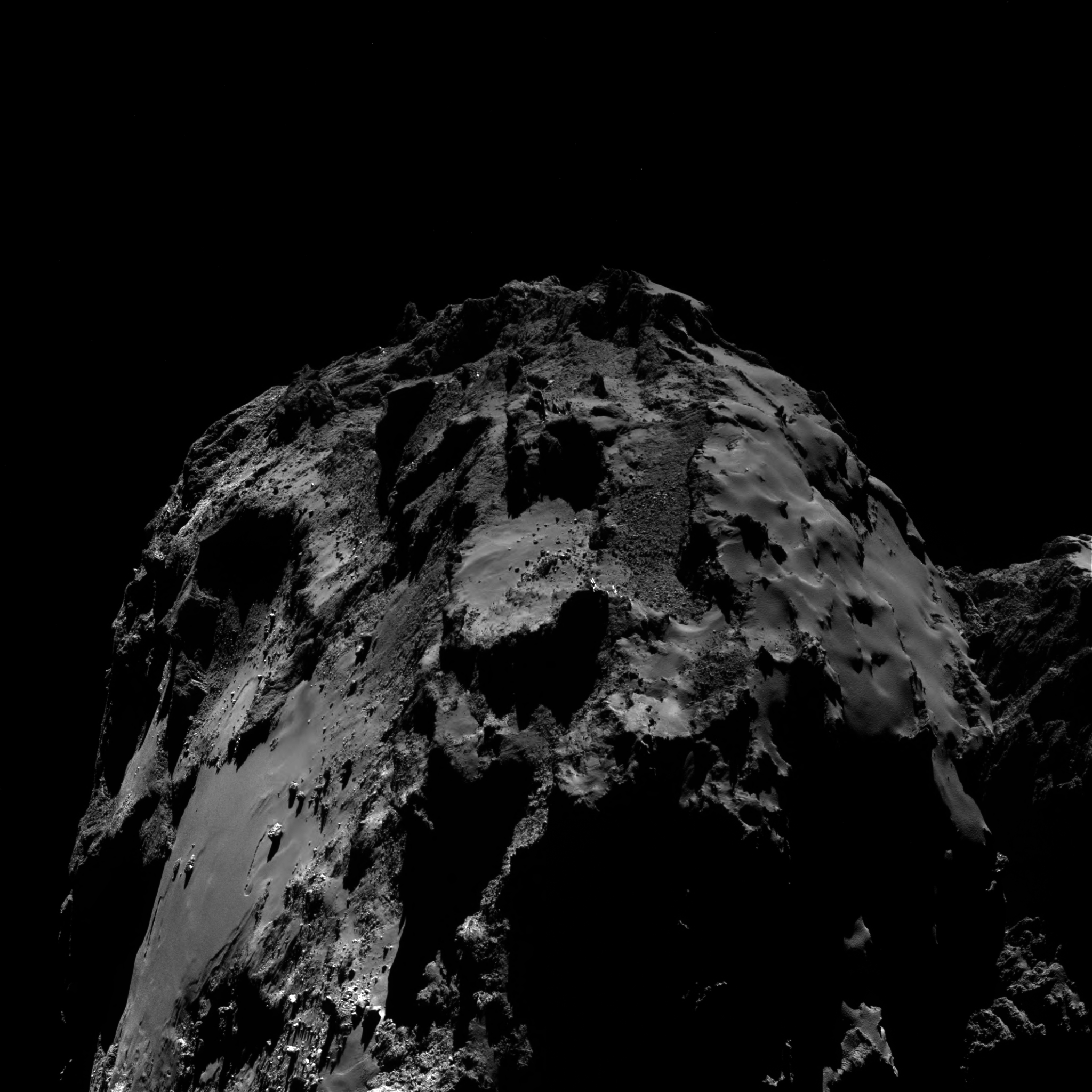
Cool image time! Below the fold are two images taken by Rosetta of the smooth boulder-strewn area on Comet 67P/C-G called Imhotep, which has been featured many times by the Rosetta science team. The image on the left was taken October 26, 2014 soon after the spacecraft’s arrival at the comet. The image on the right was taken August 17, 2016, almost two years later after it had completed its close approach to the Sun. With both images I have cropped them and reduced their resolution to fit here. With the more recent image I have also stretched it horizontally to better match it to the older image.

The point? The giant boulders on this smooth region act as markers so that we can more easily compare the region and see how it has changed with time. The newer image clearly shows a loss of material from the surface, with the depressions in the smooth areas having grown much larger and in some areas much deeper. At the same time, there has been a softening in some of the edges between the lower and higher areas, especially in the middle of the smooth region.

What will happen here in the future? It appears that the smooth area is actually pond of dust that is slowly evaporating away with each close approach to the Sun, leaving behind the solid bedrock pinnacles within it that only appear as boulders because they are mostly buried. Eventually, when the dust is gone, some of those pinnacles will break away as well.
» Read more

More details about Proxima Centauri’s Earthlike exoplanet

Link here. Lots of background into the discovery itself, but I think these paragraphs really sum things up:

“The search for life starts now,” says Guillem Anglada-Escudé, an astronomer at Queen Mary University of London and leader of the team that made the discovery.

Humanity’s first chance to explore this nearby world may come from the recently announced Breakthrough Starshot initiative, which plans to build fleets of tiny laser-propelled interstellar probes in the coming decades. Travelling at 20% of the speed of light, they would take about 20 years to cover the 1.3 parsecs from Earth to Proxima Centauri.

Proxima’s planet is at least 1.3 times the mass of Earth. The planet orbits its red-dwarf star — much smaller and dimmer than the Sun — every 11.2 days. “If you tried to pick the type of planet you’d most want around the type of star you’d most want, it would be this,” says David Kipping, an astronomer at Columbia University in New York City. “It’s thrilling.”

The human race now has a real interstellar target to aim for. Don’t be surprised if we get there sooner than anyone predicts.

Rosetta photographs outburst on Comet 67P/C-G

The Rosetta science team today released data and images of a February 19, 2016 outburst on Comet 67P/C-G that the spacecraft was able to photograph, as it happened.

A strong brightening of the comet’s dusty coma was seen by the OSIRIS wide-angle camera at 09:40 GMT, developing in a region of the comet that was initially in shadow. Over the next two hours, Rosetta recorded outburst signatures that exceeded background levels in some instruments by factors of up to a hundred. For example, between about 10:00–11:00 GMT, ALICE saw the ultraviolet brightness of the sunlight reflected by the nucleus and the emitted dust increase by a factor of six, while ROSINA and RPC detected a significant increase in gas and plasma, respectively, around the spacecraft, by a factor of 1.5–2.5.

In addition, MIRO recorded a 30ºC rise in temperature of the surrounding gas. Shortly after, Rosetta was blasted by dust: GIADA recorded a maximum hit count at around 11:15 GMT. Almost 200 particles were detected in the following three hours, compared with a typical rate of 3–10 collected on other days in the same month.

Be sure an look at the animated gif at the link.

“Our projections were completely wrong.”

The uncertainty of science: Despite predictions that global warming would destroy the world’s coral reefs, scientists as well as divers who visit the reefs regularly have found that they are instead thriving, with almost no damage.

[R]ecent research has shown some coral reefs are coming back to life much more quickly than scientists believed possible. Scientists found Coral Castles teeming with life during a 2015 dive, despite declaring the reef dead 13 years ago. “Everything looked just magnificent,” said Jan Witting, the dive’s lead scientist who works at the Sea Education Association, told The New York Times. “Last year, the whole place was holding its breath,” Witting said. “The whole ocean’s in bloom this year.”

Rangiroa lagoon in French Polynesia had rebounded just 15 years after being devastated by the incredibly strong 1998 El Nino warming event. “Our projections were completely wrong,” marine biologist Peter Mumby told BBC News in 2014. “Sometimes it is really nice to be proven wrong as a scientist, and this was a perfect example of that.”

These bad predictions, some as recently as April 2016, not only were not based on facts, they did serious harm to the tourist industry and the people who depend on it.

“Scientists had written off that entire northern section as a complete white-out,’’ Chris Eade, owner of the diving boat Spirit Of Freedom, told The Courier-Mail in an interview. “We expected the worst,” Eade said. “But it is tremendous condition, most of it is pristine, the rest is in full recovery. It shows the resilience of the reef.”

Eade said dire predictions about the demise of the Great Barrier Reef has hurt tourism businesses — a $5 billion industry. He’s particularly angry with scientists who estimated bleaching had hurt 93 percent of the Great Barrier Reef, mostly concentrated in the northern half. “Between 60 and 100 percent of corals are severely bleached on 316 reefs, nearly all in the northern half of the Reef,” Terry Hughes, the lead coral reef scientist at Australia’s James Cook University, said in April. Hughes’ research was based on aerial surveys of 911 reefs, and found 316 reefs were “severely bleached.” But that’s not what Eade and other reef tourist operators have observed taking people out for daily dives. [emphasis mine]

In other words, the scientist really didn’t look at the reefs. Instead, he took a quick distant survey and declared disaster, probably to promote the agenda of global warming.

Earthlike exoplanet discovered orbiting the nearest star

Worlds without end: An Earthlike exoplanet has been discovered in the habitable zone and orbiting Proxima Centauri, the nearest star to the Sun.

The CBC/AP story above doesn’t give many details, mainly because this story is breaking the Thursday embargo, when the actual science paper will be released. Expect a lot more news stories then about this, which probably ranks as one of the biggest science discoveries in history.

Since the embargo is broken, here are some facts from one of the press releases:

The planet, called Proxima b, orbits its parent star every 11 days and has a temperature suitable for liquid water to exist on its surface. This rocky world is a little more massive than the Earth, and is the closest planet outside our solar system. Planets around other stars are commonly referred to as exoplanets.

…Although Proxima b orbits much closer to its star than Mercury does to the Sun in the solar system, the star itself is far fainter than the sun. As a result Proxima b lies well within the habitable zone around the star and has an estimated surface temperature that would allow the presence of liquid water. Despite the temperate orbit of Proxima b, the conditions on the surface may be strongly affected by the ultraviolet and X-ray flares from the star — these would be far more intense than those the Earth experiences from the Sun.

They first had a hint of the planet’s existence in 2013 (which explains the unsourced rumors I’ve heard periodcally in the past few years about a exoplanet around Proxima Centauri) and spent the past two-plus years making absolutely sure they understood their data.

Another balanced rock!

A new balanced rock

Cool image time! The image to the right, cropped to show here, was taken by Curiosity’s mast camera this week as it surveys the upcoming terrain so that scientists can choose its route. It shows another balanced rock that is far more unbalanced than the one the rover passed last week.

In reviewing the survey images, I am not exactly sure whether this rock is located along Curiosity’s future route, as I have not been able to locate it in any of the panorama images the rover has taken. If it is in the gap they are aiming for, then we shall soon see some additional close-ups. If not, then we will have to content ourselves with some other views that, when you think about it, are really just as good.

A visit to OSIRIS-Rex clean room

NASA recently gave a press tour of the clean room where the asteroid probe OSIRIS-Rex is being prepped for its September 8 launch, and one reporter from that tour wrote a very nice description of what it was like.

After such a tour, most reporters write up stories that describe the spaceship, its mission, and its status. This reporter however did something better. He wrote up what it’s like to enter a clean room for a mission only weeks from launch.

Our belongings have been lined up in a row alongside us. And then the dog arrives.

It’s a beautiful specimen of a german shepherd, long and enthusiastic, being led by a sturdy military-type with a buzzcut wearing what looks like mercenary gear. The dog is led down the row of belongings once. Then twice. Then he and his owner head back to their truck and drive off. We have passed. We are free to go into the blessed blast of cool air on the bus that’s been idling alongside us for what seems like hours, but has really only been about 15 minutes.

And that’s only the start. Read it all. Quite fascinating.

Fossilized rivers on Mars

The uncertainty of science: Using high resolution images from Mars Reconnaissance Orbiter scientists have identified more than 10,000 miles of fossilized rivers on Mars.

The new study examined images covering an area roughly the size of Brazil at a much higher resolution than was previously possible – six metres per pixel compared to 100 metres per pixel. While a few valleys were identified, the team revealed the existence of many systems of fossilised riverbeds which are visible as inverted channels spread across the Arabia Terra plain.

The inverted channels are similar to those found elsewhere on Mars and Earth. They are made of sand and gravel deposited by a river and when the river becomes dry, the channels are left upstanding as the surrounding material erodes. On Earth, inverted channels often occur in dry, desert environments like Oman, Egypt, or Utah, where erosion rates are low – in most other environments, the channels are worn away before they can become inverted. “The networks of inverted channels in Arabia Terra are about 30m high and up to 1–2km wide, so we think they are probably the remains of giant rivers that flowed billions of years ago. Arabia Terra was essentially one massive flood plain bordering the highlands and lowlands of Mars. We think the rivers were active 3.9–3.7 billion years ago, but gradually dried up before being rapidly buried and protected for billions of years, potentially preserving any ancient biological material that might have been present,” added Joel Davis.

These geological forms are different than most of the more well-known Martian channels in that they are not channels but meandering riverlike ridges, higher than the surrounding terrain. Arabia Terra, where they are located, is a transition region in the northern mid-latitudes between Mars’s southern highlands and its northern flat plains, where some believe an ocean once existed.

China unveils its 2020 Mars lander/rover

The competition heats up: China today released design concepts of its planned 2020 Mars lander and rover.

According to Ye Peijian, one of China’s leading aerospace experts and a consultant to the program, the 2020 mission will be launched on a Long March-5 carrier rocket from the Wenchang space launch center in south China’s Hainan province. The lander will separate from the orbiter at the end of a journey of around seven months and touch down in a low latitude area in the northern hemisphere of Mars where the rover will explore the surface.

If they succeed they will have definitely moved ahead of Russia in the ranks of space-faring nations.

Contact re-established with dead solar satellite

Good news! After almost two years since contact was lost, NASA has re-established communications with Stereo-B, one of two solar research satellites designed to study the hemisphere of the Sun that does not face the Earth.

NASA re-established contact with a wayward sun-watching science satellite Sunday nearly two years after the spacecraft suddenly dropped off line during a test, the agency said in a statement Monday. NASA’s Deep Space Network, or DSN, “established a lock on the STEREO-B (spacecraft’s) downlink carrier at 6:27 p.m. EDT,” NASA said in a statement. “The downlink signal was monitored by the Mission Operations team over several hours to characterize the attitude of the spacecraft and then transmitter high voltage was powered down to save battery power. “The STEREO Missions Operations team plans further recovery processes to assess observatory health, re-establish attitude control and evaluate all subsystems and instruments.”

This is a big deal. Not only is it a testament to the spacecraft’s good design, it demonstrates the skill of the engineers at NASA who have regained contact.

Mars’ wet streaks might not be wet

The uncertainty of science: An analysis of five years of data from Mars Odyssey suggests that the dark streaks flowing down Martian slopes might contain very little and possibly no water at all.

This year, planetary scientists Christopher Edwards and Sylvain Piqueux took a closer look at the feature using a thermal imaging instrument on board Mars Odyssey, another orbiter. They found no temperature differences between the dark RSL streaks and surrounding terrain — which suggests that the streaks aren’t really patches of wet sand streaming down a slope. At best, they say, the RSLs could contain no more than 3 percent liquid water — making them more like mildly damp, slightly salty dirt. And that’s an optimistic interpretation, Edwards said; it’s possible the RSLs contain no water at all. “Why this process is happening in this area, or what is causing this darkening, I don’t think is exactly obvious at this point,” he continued. “But to say it’s flowing liquid water, I don’t think it’s the whole story. It’s not necessarily even the right story.”

This data once again illustrates why we must be very careful with our conclusions when looking at features on an alien world that seem to resemble things we are familiar with here on Earth. Just because they might look alike is not evidence that they are the same. Mars has a very different gravitational field (one-third of Earth’s) and a significantly different make-up. We might be witnessing processes we’ve never seen before that produce features that mimic Earthlike forms.

Beyond Murray Buttes

Panorama ahead for Curiosity, Sol 1438

Time for a Curiosity update. Above is a panorama I’ve created from raw images released today from the rover’s left navigation camera of the mesa filled terrain within which Curiosity now sits. Since my last update they have traveled about 200 feet south, moving away from the mesa with the balanced rock

Below the fold is a Mars Reconnaissance Orbiter image with Curiosity’s path indicated. I have marked the balanced rock with an X, and have indicated with the yellow lines the area covered by the panorama above.

They appear to be aiming due south for the narrow gap between the long ridge-like mesas. This will bring Curiosity out into the open and sloping terrain that can be seen in the distance in the last image of my last update. I suspect they want to get a closer look at those parallel grooves, even if it means the journey will be a little rougher.
» Read more

Dione’s global geology

Dione

Cool image time! The picture of Saturn’s moon Dione, taken by Cassini in April 2015 and reduced in size to show here, shows a range of global tectonic geological features. The impact craters we of course understand, but the white linear features are more puzzling. They are probably related to a heating and cooling process, but the full nature of that process is at present not fully understood. Tidal effects and the planet’s cooling over time both contributed, but to what extent is not yet known. Add on top of that the violent effect of impact and the process gets even more complicated. Moreover, do the linear features suggest present geological activity, or are they evidence of past events? Your guess is as good as mine.

Murray Buttes panorama by Curiosity released

The Curiosity science team has released a full panorama taken by Curiosity of Murray Buttes prior to its journey through them.

The reason I am not posting this new panorama here on Behind the Black is because I had already posted an almost identical panorama more than a week ago, and my assembled panorama used higher resolution images from Curiosity and was not partly obscured by Curiosity itself. Moreover, I provided better context for that panorama, placing it within Curiosity’s overall travels, something NASA in today’s press release fails to do.

So, if you want to see the best cool images from space and see them sooner than everyone else, why bother reading NASA press releases? Read Behind the Black instead! :)

An isolated dune on Mars

Isolated dune on Mars

Close-up of Dune

Cool image time! The image above, cropped and rotated to post it here, shows a single isolated large dune inside an unnamed crater on Mars. The image was taken by Mars Odyssey on June 5. To the right is a close-up of the dune itself. Its isolated nature as well as the darkness of its sand in comparison with the surrounding territory has probably got some planetary scientists scratching their heads. Furthermore, the darker streaks that appear to flow down the dune are quite intriguing. Were they formed by briny seep water, as has been found with other seasonal dark slope streaks? Or are they evidence of sand avalanches?

I imagine that there will be an effort to monitor this dune over time, to see if it changes.

Balanced Rock at last

Balanced rock close-up

My pessimistic prediction that Curiosity’s science team would take the least risky route and thus not pass close to the butte with the balanced rock has fortunately turned out to be very wrong! They have moved Curiosity into the closest gap to get the best views of both the balanced rock as well as the butte behind it. The image on the right, cropped, was taken by the rover’s mast camera as Curiosity entered the gap between the buttes. It shows clearly that balanced rock broke off from the layers above and landed on its side.

The image below the fold shows the same butte after Curiosity had passed the balanced rock (inside red box).
» Read more

A fine collection of Rosetta images

Comet 67P/C-G

Many cool images! The Rosetta team has released a bunch of very nice images taken of Comet 67P/C-G during August when the spacecraft was flying in close. The image on the right, cropped and reduced in resolution to post here, shows the comet’s large lobe, with the narrow neck to the left. Make sure you check out the full resolution image. It was taken on August 10, 2016 from about 8 miles away, and has a resolution of less than four feet per pixel. If a person was standing there you could just see them!

What I find most fascinating is the incredible curvature of the comet’s surface. The smooth area on the left, dubbed Imhotep (images of which have been posted here previously), has several big boulders on its flat surface. If you stood there, the ground would be down and horizontal. Walk only a short distance and you quickly reach the curving horizon and that flat area would look like a steep slope dropping down behind you. Yet, the boulders do not roll down hill! Walk a short distance more and you begin to enter the neck region, with giant walls rising above you, until you start to walk up them and they become the floor!

The landing site for ExoMars’ Schiaparelli lander

This ESA press release provides a nice overview of the landing area that the Schiaparelli lander on ExoMars is targeting.

The landing ellipse, measuring 100 x 15 km, is located close to the equator, in the southern highlands of Mars. The region was chosen based on its relatively flat and smooth characteristics, as indicated in the topography map, in order to satisfy landing safety requirements for Schiaparelli. NASA’s Opportunity rover also landed within this ellipse near Endurance crater in Meridiani Planum, in 2004, and has been exploring the 22 km-wide Endeavour crater for the last five years. Endeavour lies just outside the south-eastern extent of Schiaparelli’s landing ellipse.

Since the primary missions of both Schiaparelli and the ExoMars orbiter, dubbed the Trace Gas Orbiter, is test the technology for getting to and landing on Mars (in preparation for the more challenging 2020 ExoMars mission), I suspect that they chose this very well studied and already visited area to make this test landing less risky.

Side note: ExoMars successfully completed its second and last planned mid-course correction yesterday in preparation for its October arrival at Mars.

Curiosity prepares to move on

Route through Murray Buttes

After several days of drilling, the Curiosity science team is preparing to move forward. As one member of the team notes,

After a short drive we’ll acquire images for context and targeting. Overnight, Curiosity will complete a SAM electrical baseline test to monitor instrument health. Based on some of the recent Mastcam images that we’ve acquired…, the view ahead should be quite scenic as we drive through the Murray Buttes!

The image above is a close-up of those Buttes, showing Balanced Rock on the left, taken from one of three raw left navigation images. The image below is a panorama I have created from those navigation images, with an inset box to show the location of the above picture.
» Read more

Craters on Ceres

craters on Ceres
Cool image time! The image above, cropped and reduced in resolution to show here, was taken on May 30, 2016 by Dawn from 240 miles away. It looks northward at the dwarf planet’s horizon, and has a resolution of about 120 feet per pixel.

My only comment is to note how soft the terrain looks. I realize this is not really an accurate description, but data has shown that Ceres has a somewhat low density and is somewhat malleable. It sure looks that way here.

Rivers of liquid carved deep gorges on Titan

Cassini radar data of Via Flumina

Cool image time! New data from Cassini has now both confirmed that there is liquid inside some of the river-like formations on Titan, and that this liquid has carved these formations into very deep gorges.

The Cassini observations reveal that the channels — in particular, a network of them named Vid Flumina — are narrow canyons, generally less than half a mile (a bit less than a kilometer) wide, with slopes steeper than 40 degrees. The canyons also are quite deep — those measured are 790 to 1,870 feet (240 to 570 meters) from top to bottom.

The branching channels appear dark in radar images, much like Titan’s methane-rich seas. This suggested to scientists that the channels might also be filled with liquid, but a direct detection had not been made until now. Previously it wasn’t clear if the dark material was liquid or merely saturated sediment — which at Titan’s frigid temperatures would be made of ice, not rock.

The diagram on the above right is from the paper itself, and shows some of the radar data obtained by Cassini. It also illustrates the deep and narrow nature of Via Flumina. This is almost the equivalent of what we call slot canyons on Earth, formed by periodic flash floods that cut their way down as the surface is slowly uplifted by other processes.

The new radar data showed that the surface at the base of the gorge was smooth and flat, just as you’d find if that base was filled with liquid.The altimeter data showed that gorge’s elevation matched that of Titan’s lakes at its insurgence, but as you traveled upstream the elevation rose, just as it does on any river on Earth. Moreover, this data was reasonably trustworthy as they had already used Cassini to successfully do exactly the same thing — identify a known river — when it flew past Earth on its way to Saturn.

Be prepared for one piece of misinformation when the press reports on this story, almost certainly caused by the American Geological Union’s press release about this paper. That press release incorrectly claims that the paper confirmed that these are methane rivers. It does no such thing. It only shows that the gorges have a liquid in them, and that the liquid almost certainly formed the gorges. Though methane is a very likely candidate for this liquid based on what we know of Titan, the actual make-up of the river remains uncertain.

I therefore predict our incompetent modern mainstream press will only read this press release and not the paper itself, and thus they will tout these incorrectly as methane rivers.

Below is a cropped Cassini radar image of Via Flumina, showing its river-like appearance. Scientists always suspected these were formed by flowing liquid. Now they have strong evidence from within the gorge to justify that suspicion.

Via Flumina on Titan

One Year on Earth – Seen From 1 Million Miles

An evening pause: This video release from NASA made the rounds a few weeks ago. It isn’t news, but it is cool. One important fact noted during this video is that the Earth’s cloud cover both warms and cools the planet. What wasn’t noted was that there is gigantic uncertainty about how much the clouds warm and cool, which is one of the main reasons no climate models have been even close to successfully predicting the climate.

Hat tip Wayne DeVette.

Wind erosion on Mars

Wind erosion on Mars

Cool image time! The image on the right, cropped to show here, was taken by Mars Odyssey. While the features shown appear at first glance to have been formed by water, they have instead in etched by wind.

The narrow ridge/valley system seen in this image are a feature called yardangs. Yardangs form when unidirectional winds blow across poorly cemented materials. Multiple yardang directions can indicate changes in regional wind regimes.

The release does not say what direction the wind was blowing, but if I had to guess, I’d say from south to north.

Physicists fail to find sterile neutrino

The uncertainty of science: A year’s collection of data using IceCube, a gigantic neutrino telescope built in the icecap of Antarctica, has found no evidence of a theorized fourth type of neutrino.

To search for sterile neutrinos, Halzen’s team looked for the arrival of muon neutrinos that started life on the other side of Earth. These were originally produced by the collision of cosmic rays with air molecules in the atmosphere, and passed through the planet to reach the detector. The IceCube team hoped to find a dearth of muon neutrinos at particular energies. That would have suggested that some muon neutrinos had temporarily mutated into sterile neutrinos during their voyage.

But, after analysing the results of a year’s worth of data, the researchers found no feature suggesting the existence of sterile neutrinos around 1 eV. This is line with results from the European Space Agency’s Planck observatory, which concluded from cosmological evidence that there should only be three families of neutrinos in that mass range. “I hope that with our result and with the Planck result we are slowly walking our way back from this story,” says Halzen. The IceCube team are still taking data in their sterile neutrino hunt, but don’t expect their results to change, he adds.

Despite this null result, there is still a possibility that sterile neutrinos exist, but not at the mass predicted.

A big Perseid meteor shower on Friday?

According to a new computer model of the Perseid meteor shower, astronomers predict that there could be a big peak of shooting stars on Friday.

Russian astronomer Mikhail Maslov and Finnish astronomer Esko Lyytinen predict that this year the Earth will pass through a stream of cometary material shifted towards us by Jupiter’s gravitational field. According to their model, and work by French scientist Jeremie Vaubaillon, we could see a steep rise in activity from late evening on 11 August to 0500 BST on 12 August.

The Perseids are typically active from around 17 July to 24 August, although for most of that period only a few meteors an hour will be visible. During the peak, and if the predictions by Maslov, Lyytinen and Vaubaillon are right, as many as 100 meteors or more may be seen each hour. This year, the light from the waxing gibbous Moon will interfere to some extent for the first part of the night, so observers are advised to look out in the early morning hours after midnight when the Moon is very low in the sky or has set.

If this is true, Diane and I might have lucked out, as we will be heading for our annual Grand Canyon hike to the bottom on Friday.

The mystery of Tabby’s Star deepens

The uncertainty of science: New data from Kepler has made it even more difficult for scientists to explain the strange fluctuations and dimming of Tabby’s Star.

KIC 8462852, as it is more properly known, flickers so erratically that one astronomer has speculated that nothing other than a massive extraterrestrial construction project could explain its weird behaviour. A further look showed it has been fading for a century. Now, fresh analysis suggests the star has also dimmed more rapidly over the past four years – only adding to the enigma. “It seems that every time someone looks at the star, it gets weirder and weirder,” says Benjamin Montet at the California Institute of Technology, who led the study.

There are as yet no natural explanations for the star’s dimming.

Sunspot ramp down continues

Below is NOAA’s monthly update of the solar cycle, posted by them on August 7. It shows the Sun’s sunspot activity in July, with annotations.

July 2016 Solar Cycle graph

The graph above has been modified to show the predictions of the solar science community. The green curves show the community’s two original predictions from April 2007, with half the scientists predicting a very strong maximum and half predicting a weak one. The red curve is their revised May 2009 prediction.

As expected, there was a recovery in sunspot activity in July compared to June. Also as expected, the recovery was not significant, so that it appears, based on the past two months, as if the ramp down to solar minimum is accelerating so that solar minimum will occur sooner than expected, possibly as soon as two years.

I would not put much stock on that prediction, however. When sunspot activity first reached this level during the past solar cycle in late 2005, it still took three more years before solar minimum was reached. If this cycle matches the last, that would mean that this cycle, from minimum to minimum, will have lasted 10 years, making a short solar cycle though not one of the shortest. However, it is more likely that the ramp down will stretch out, as it usually does, gliding downward to solar minimum in a slow gentle curve that makes for a full cycle of about 11 years.

New evidence suggest lake once existed in Gale Crater

Scientists have concluded that mineral veins seen by Curiosity in Gale Crater were created when a lake existed there.

The study suggests that the veins formed as the sediments from the ancient lake were buried, heated to about 50 degrees Celsius and corroded. Professor John Bridges from the University of Leicester Department of Physics and Astronomy said: “The taste of this Martian groundwater would be rather unpleasant, with about 20 times the content of sulphate and sodium than bottled mineral water for instance!”

1 133 134 135 136 137 259