Largest volcanic eruption in years detected on Io

Using instruments on a ground-based telescope, one scientist based at the Planetary Science Institute (PSI) in Arizona has detected the largest volcanic eruption in years on the Jupiter moon Io.

PSI Senior Scientist [Jeff] Morgenthaler has been using IoIO, located near Benson, Arizona to monitor volcanic activity on Io, since 2017. The observations show some sort of outburst nearly every year, but the largest yet was seen in the fall of 2022. Io is the innermost of Jupiter’s four large moons and is the most volcanic body in the Solar System thanks to the tidal stresses it feels from Jupiter and two of its other large satellites, Europa and Ganymede.

IoIO uses a coronagraphic technique which dims the light coming from Jupiter to enable imaging of faint gases near the very bright planet. A brightening of two of these gases, sodium and ionized sulfur, began between July and September 2022 and lasted until December 2022. The ionized sulfur, which forms a donut-like structure that encircles Jupiter and is called the Io plasma torus, was curiously not nearly as bright in this outburst as previously seen. “This could be telling us something about the composition of the volcanic activity that produced the outburst or it could be telling us that the torus is more efficient at ridding itself of material when more material is thrown into it,” Morgenthaler said.

The material released by this eruption could impact Juno during future close approaches of Jupiter.

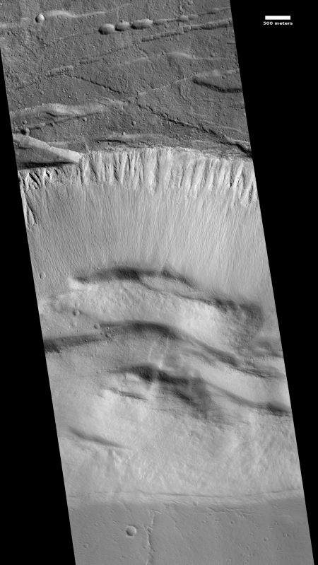
The steep slumping wall of a Martian volcano caldera

Caldera wall

Cool image time. The Mars Reconnaissance Orbiter science team today released a nice captioned image of the steep wall of the caldera of Ascraeus Mons, the northernmost of the three giant volcanoes that lie to the east of Olympus Mons, the biggest volcano of all. The image on the right, reduced and cropped, shows that steep wall, with full image available by clicking on it. The caption from the release focuses on the fluted upper parts of the wall.

We can see chutes carved into the soft dust that has built up on the slope, with some similarities to gully landforms elsewhere on the planet.

More revealing to me is how this image reveals the slumping that is slowing eroding the caldera’s walls while also making that caldera larger. First, the plateau above the cliff shows multiple small cliffs and pit chains, all more or less parallel to the wall. This suggests that the plateau is over time breaking apart and falling into that caldera. Think of it as an avalanche in slow motion, with the upper plateau separating into chunks as sections slowly tilt down toward eventual collapse. As these chunks separate, they cause cracks to form in that plateau, and hence the parallel cliffs and strings of pits.

On the floor of the caldera we can see evidence of past chunks that did fall, piled up in a series terraces at the base of the wall. These are covered with the soft dust that dominates Martian geology. That soft dust also apparently comprises much of the wall’s materials, and almost acts like a liquid as it periodically flows down the wall, producing the chutes at the top of the wall.

The weak Martian gravity here is an important factor that we on Earth have difficulty understanding. It allows for a much steeper terrain, that also allows structurally weaker materials to hold together that would be impossible on Earth.This image gives a taste of this alien geology, on a large scale.

Update on Hawaiian lava eruption

Link here. This news article is particularly informative, as it includes a map that outlines the extent of the lava flows and what they have engulfed, including the most recent flows that are threatening a geothermal power plant that has been providing the Big Island about 25% of its power.

“Lava flow from Fissures 7 and 21 crossed into PGV [Puna Geothermal Venture] property overnight and has now covered one well that was successfully plugged,” declared the Hawaii Civil Defense Agency in a statement released on Sunday, May 27 at 6:00 pm local time. “That well, along with a second well 100 feet [30 meters] away, are stable and secured, and are being monitored. Also due to preventative measures, neither well is expected to release any hydrogen sulfide.”

Those preventive measures included a complete shutdown of the geothermal plant, the capping of all 11 wells, and the removal of some 60,000 gallons of flammable liquid. Those precautions aside, this is the first time in history—as far as we know—that lava has ever engulfed a geothermal power plant, so it’s all uncharted territory. There’s fear that a rupture of the wells could set off an explosion, releasing hydrogen sulfide and other dangerous gasses into the environment. As of this posting, the lava flows on the PGV grounds have stopped moving.

Environmentalists often promote geothermal power as an alternative to fossil fuels. Environmentalists also sued to prevent this plant from being built because of its proximity to the volcano.

Mapping the inside of Mt St. Helens

A new array of seismometers, combined with a series of planned explosions, will be used to map the interior of the Mt. St. Helens volcano to a depth of eighty kilometers or fifty miles.

To get the job done, starting next week roughly 65 people will fan out across the mountain to deploy 3,500 small seismometers along roads and back-country trails. They will drill 24 holes some 25 metres deep, drop in industrial explosives used for quarrying, and refill the holes (see ‘Under the dome’). The plan is to detonate the explosives in separate shots over four nights. Each blast will shake the ground as much as a magnitude-2 earthquake.

Results from the active blasts will be combined with the passive seismic part of the experiment, which is already under way: 70 larger seis­mometers around the mountain are measuring how long waves from natural earthquakes take to travel through the ground. Their data can be used to probe as far as 80 kilo­metres down, says Vidale.

Photos taken 33 years ago by a photographer who died in the Mt. St. Helens eruption have been discovered and developed.

Photos taken 33 years ago by a photographer who died in the Mt. St. Helens eruption have been discovered and developed.

Reid Blackburn took the photographs in April 1980 during a flight over the simmering volcano. When he got back to The Columbian studio, Blackburn set that roll of film aside. It was never developed. On May 18, 1980 — about five weeks later — Blackburn died in the volcanic blast that obliterated the mountain peak.

Those unprocessed black-and-white images spent the next three decades coiled inside that film canister. The Columbian’s photo assistant Linda Lutes recently discovered the roll in a studio storage box, and it was finally developed.

Mars Express takes a close look at the Mars volcano Tharsis Tholus

Mars Express takes a close look at one of Mars’ giant volcanoes, Tharsis Tholus.

At least two large sections have collapsed around its eastern and western flanks during its four-billion-year history and these catastrophes are now visible as scarps up to several kilometers high. The main feature of Tharsis Tholus is, however, the caldera in its center. It has an almost circular outline, about 32 x 34 km, and is ringed by faults that have allowed the caldera floor to subside by as much as 2.7 km.

Chile’s powerful Cerro Hudson volcano is threatening to erupt

Chile’s powerful Cerro Hudson volcano has come back to life and is threatening a major eruption.

Patagonians are worried. Many remember Mount Hudson’s catastrophic eruptions of 1971 and 1991. The latter eruption was one of the most violent registered eruptions in Chile, and lasted for five months. At its peak it turned day into night, making the banks of nearby Huemules, Cupquelan and Ibáñez Rivers collapse with ash. Many areas in the region are still covered with ash, pumice and other volcanic rocks. “These are the characteristics of this highly explosive volcano,” said Juan Cayupi, a volcanologist at the National Emergency Office.

Farmers flee as Indonesia’s Mount Tambora volcano rumbles

Farmers begin fleeing as Indonesia’s Mount Tambora volcano comes back alive.

Villagers like Hasanuddin Sanusi have heard since they were young how the mountain they call home once blew apart in the largest eruption ever recorded — an 1815 event widely forgotten outside their region — killing 90,000 people and blackening skies on the other side of the globe. . . . The April 1815 eruption of Tambora left a crater 7 miles (11 kilometers) wide and half a mile (1 kilometer) deep, spewing an estimated 400 million tons of sulfuric gases into the atmosphere and leading to “the year without summer” in the U.S. and Europe.

Another Iceland volcano appears about to erupt

Another Iceland volcano, Hekla, is showing signs that it is about to erupt.

The volcano, dubbed by Icelanders in the Middle Ages as the “Gateway to Hell,” is one of Iceland’s most active, having erupted some 20 times over the past millennium, most recently on Feb. 26, 2000. It measures 4,891-feet (1,491-meters) and is located about 70 miles (110 kilometers) east of Reykjavik, not far from Eyjafjoell.

Yellowstone caldara rise has slowed

In a paper published today in Geophysical Research Letters of the American Geophysical Union, scientists note that the rise of giant volcanic caldara under Yellowstone National Park has slowed significantly since 2006 and since 2008 has actually subsided somewhat. Key quote from the paper:

Here we propose that as the caldera source continues inflating, the accumulated strain energy in the deformed crust could promote earthquakes with mechanisms such as hydrofracturing,, migration of magmatic fluids, and brittle fracturing of rocks. These events can subsequently depressurize the magmatic systems or release the accumulated strain energy, slowing the uplift or even influencing a change in motion to subsidence. In January 2010 the Yellowstone caldera experienced another large earthquake swarm at its northwestern boundary close to the location of the 1985 swarm. . . . In the following five months the caldera experienced the first overall subsidence since the inception of its uplift in 2004. This scenario is similar to that in 1985 where a reverse of caldera uplift to subsidence was temporally correlated with the largest observed Yellowstone earthquake swarm.