
Exploring the canyons and plateaus of Valles Marineris

Click for original image.
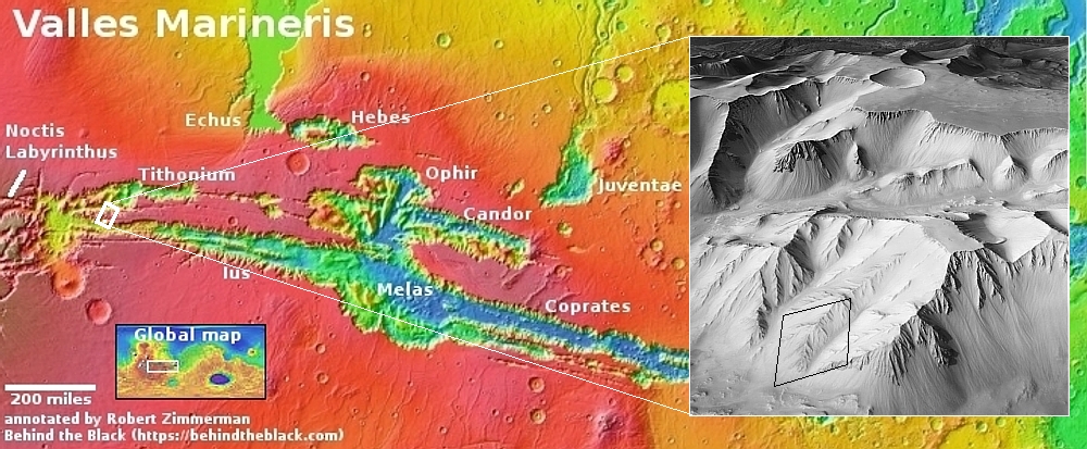
Cool image time! The picture to the right, rotated, cropped, reduced, and sharpened to post here, was taken on November 2, 2024 by the high resolution camera on Mars Reconnaissance Orbiter (MRO). It shows just one small section of a ridge that descends deep into the giant canyon Valles Marineris, the largest known canyon in the solar system.
On the overview map above, the white dot inside the rectangle marks the location, in the westernmost section of the part of Valles Marineris dubbed Ius Chasma.
For scale, the nose of this ridge descends about 7,300 feet from the top to the bottom, about half the total descent from the small isolated plateau shown in the inset. That plateau, located in the mountainous region between Ius Chasma and Tithonium Chasma, rises to approximately the same elevation as the canyon’s rims to the north and south.
What this picture shows us is that Valles Marineris on its western end is both more shallow and broken up, forming several canyons and plateaus. As the catastrophic floods that are theorized to have carved this canyon pushed their way east, they carved a deeper gorge, so that about 1,500 miles to the east the canyon walls are considerable higher, from 20,000 to 30,000 feet in some places.
As always, the tourist in me can’t help look at this terrain and envision inns and hiking trails. Imagine homesteading that plateau where you build a hotel and trails. Since I expect much transportation on Mars will be by air, your guests would fly in, land at a heliport, and spend their visit hiking down into the canyons that surround them.
Damn! The future is going to so grand!


