Clara Cernat & Thierry Huillet – Monti Csardas
An evening pause: Stay with it. If you don’t recognize the title you will definitely recognize the music.
Hat tip Judd Clark.
An evening pause: Stay with it. If you don’t recognize the title you will definitely recognize the music.
Hat tip Judd Clark.
Courtesy of Jay, BtB’s stringer.
From the tweet: “Probably got snagged on the array when the fairing separated.” This conclusion is based on the images released two days ago.
This was posted by ULA’s CEO, Tory Bruno. He does not say when this was done, nor provide clarity on a test or launch schedule.
And as the agency does so often, it now shuts things down, having no plans to fly it again. It could be scaled up for future Mars missions, but no such mission is presently planned. ULA, which partnered with NASA on the test, is likely to take this technology and use it to recover the 1st stage engines on Vulcan.
The tweet shows a picture of a small scale prototype test. An animation of the idea can be seen here. If built it would be a rare thing for China, a new concept not copied from others.

Bring a gun to a knife fight: In a victory for free speech, a federal judge has ruled that the censorship and banning of some parents by the Forsyth County Board of Education in Georgia was unconstitutional, and must cease immediately.
This is a follow-up of a previous blacklist story from back in August, when those parents sued the board because it would not permit them to speak at board meetings during public comment about the pornography the board was allowing in schools.
Multiple district residents, including Mama Bears members and plaintiffs in the lawsuit Alison Hair and Cindy Martin, have used their time to read aloud from school library books they consider pornographic. Yet while these materials are available to kids in school, the Chair has cut off and banned speakers who read from them at Board meetings when he deems the language inappropriate or profane.
» Read more
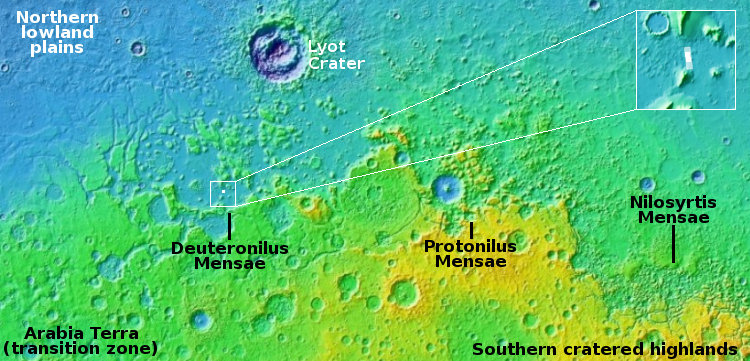
For today’s cool image we return once again to glacier country in the northern mid-latitudes of Mars. The picture to the right, rotated, cropped, reduced, and enhanced to post here, was taken on August 28, 2022 by the high resolution camera on Mars Reconnaissance Orbiter (MRO). It shows a spot where I think glacial flows coming from the north and south have collided at a low point. The white dot in the box on the overview map above marks its location, with the inset showing the mesas to the north and south that suggest this flow pattern.
What makes these colliding flows especially cool is the source of the northern flow. It appears that came out of the impact heat from that crater, which caused the ice on the downhill side to flow. You can also see the same phenomenon a short distance to the east, with a much smaller crater, likely a secondary impact from the first.
Note also the glacial fill inside the larger crater. This impact happened on top of older glaciers, but later climate cycles caused more ice to be deposited within the crater afterward. That this glacial fill appears terraced and thus layered also suggests that there were several if not many such later climate cycles.
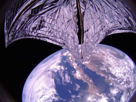
LightSail-2, shortly after deployment in 2019.
LightSail-2, an experimental solar sail built by the Planetary Society, finally ended its mission this week, with the test sail burning up in the atmosphere upon re-entry.
LightSail 2 was launched aboard a SpaceX Falcon Heavy rocket in June 2019, settling into an initial orbit at an altitude of around 720 km (450 miles). At that height, the Earth’s atmosphere is still thick enough to create drag, which would threaten to eventually pull the spacecraft down.
But that’s where the plucky little satellite’s special ability came in. Although it’s only the size of a shoebox, LightSail 2 unfurled a big reflective sheet, called a solar sail, about the size of a boxing ring. The idea is that photons from sunlight strike this sail and generate tiny amounts of thrust, allowing the craft to change its orbit.
And LightSail 2 demonstrated this concept beautifully. In three and a half years, the spacecraft completed around 18,000 orbits and traveled 8 million km (5 million miles), adjusting its orbit continuously to keep itself aloft. But all good things must come to an end, and sometime on November 17, drag finally won the tug-of-war and pulled the spacecraft back to Earth.
LightSail-2 was the third time a light sail had been flown in space, with the first, Ikaros, deployed by the Japanese in 2010 and flown in solar orbit through 2012. That mission was successful in using sunlight to accelerate the sail. This was followed by LightSail-1 in 2015. That mission has some communications problems, but eventually succeeded in its main engineering mission by testing the sail deployment system.
Boeing yesterday announced that it is doing a major reorganization of its defense, space, and security divisions.
The action will replace numerous executives while reducing eight different divisions into four.
Such action was long overdue, considering Boeing’s many recent engineering failures, from space (Starliner) to aviation (737-Max), all of which demanded such a reorganization and consolidation, simply to pay the bills if not to fix serious management shortcomings. The bad economy has only made this more urgent.
NASA yesterday announced that Japan has agreed to remain on ISS through 2030, the first international partner to do so, and in exchange will get a Japanese astronaut flight to the Lunar Gateway station.
Under the Gateway Implementing Arrangement, NASA will provide an opportunity for a Japan Aerospace Exploration Agency (JAXA) astronaut to serve as a Gateway crew member on a future Artemis mission. This formally represents the first commitment by the U.S. to fly a Japanese astronaut beyond low-Earth orbit aboard NASA’s Space Launch System (SLS) rocket and Orion spacecraft.
I remain very doubtful in the long run these flights will occur on SLS, which simply cannot launch frequently enough to make the entire program viable. More likely with time the rocket will be replaced by other commercial carriers.
Skyroot, a commercial rocket startup in Indian, yesterday became the first Indian company to complete a rocket launch, sending its Vikram-S suborbital rocket on a short flight.
I have embedded the launch below, cued to just before lift-off. The launch itself, which lasted only about six minutes, reached a elevation of just under 56 miles, tested of the rocket’s first stage, as well as a number of other systems.
» Read more
After a review of the test data produced during its standard dress rehearsal countdown and static fire prior to launch, SpaceX decided to cancel a Falcon 9 launch yesterday, carrying 52 Starlink satellites.
The first stage booster had previously launched 10 times, though it is not clear if this is the cause of the delay.
It’s not the first time SpaceX has delayed a launch indefinitely after a static fire test, but it is the first time in years. SpaceX semi-regularly stands down from launch attempts to conduct inspections or complete minor repairs or component replacements when data is amiss or contradictory, but those plans tend to mention the next launch target. This time, even SpaceX’s website has been scrubbed to say that “a new target launch date [will be announced] once confirmed.”
The last time a prelaunch static fire was explicitly blamed for a launch delay was in August 2019, when SpaceX fired up a Falcon 9 rocket ahead of its Amos-17 launch, didn’t like what it saw, decided to replace a valve on the booster, and then conducted a second static fire test to clear the rocket to launch. It’s possible that Starlink 2-4’s sequence of events will end up being similar.
The first test launch of ABL’s RS1 rocket aborted at T-0 yesterday, just as the rocket ignited its engines.
From a company tweet:
RS1 aborted terminal count during ignition. The vehicle is healthy, and the team is setting up to offload propellant for today. More information to come on our next opportunity.
Though it appears all is well with the rocket, the company has not yet announced a new launch date. The present launch window closes November 21, 2022.
Courtesy of BtB’s stringer Jay, who trolls Twitter so we don’t have to.
The plan is for the dish to become operative in ’25. It remains a puzzle. Shouldn’t the recently upgraded Deep Space Network provide this service?
Wanna bet they won’t meet this date either?
The work was done yesterday, and was the third for the Shenzhou-14 crew.
The link goes to the Chinese language version, with only a small excerpt translated into English.
The launch, set for December 7th, will the the company’s first from Wallops.

What American universities are aggressively working towards
They’re coming for you next: According to a recent study, anti-Semitic attacks against Jews have increased drastically on American college campuses in 2021 and 2022, rising in lock-step with the introduction of critical race theory and its anti-white, anti-American, and pro-Marxist agenda.
There were 254 attacks on 63 different college campuses with large Jewish populations, with Harvard University, the University of Chicago, Tufts University, UCLA, and Rutgers University having the highest number of incidents, according to a report by the AMCHA Initiative, a Jewish advocacy group that says its findings expose an “insidious,” never-before-revealed campus trend.
» Read more

The Ukraine War as of September 11, 2022. Click for full map.

The Ukraine War as of November 16, 2022. Click for full map.
In the two months since my last update on the Ukraine Way in September, the steady and continuing retreat of the Russians has continued, with the Ukrainians last week finally retaking all the territory north of the Dnipro River, including the city of Kherson.
The two maps to the right, created by the Institute for the Study of War (ISW) and simplified, reduced, and annotated to post here, show these gains, with the top map from their September 11, 2022 analysis and the bottom from their November 16, 2022 update. Pink areas are regions controlled by the Russians. Blue areas are regions retaken by the Ukraine. Red-striped areas are regions captured by Russian in its 2014 invasion. Blue-striped areas are regions inside Russian-occupied territories that have seen strong partisan resistance. The green lines in the top map mark the locations of important rivers.
Overall, the military actions of the Russians have continued to be haphazard, poorly thought out, and inexplicable, as they have been from the start of this war. For example, even as the Ukrainians were continuing their steady gains in the north, the Russians seemed relatively uninterested. Instead, it continued its attempts to gain ground in the middle, near Donetsk, as indicated by the two green circles. The Russians have been attempting for months to make gains in this area. Though they have captured some territory, those captures have been tiny and very costly. Nor have these captures done anything to impact the Ukrainian gains elsewhere.
» Read more
The uncertainty of science: Astronomers using the Webb Space Telescope are finding in very early universe many more galaxies that are also far more developed then had been predicted.
The Webb observations nudge astronomers toward a consensus that an unusual number of galaxies in the early universe were so much brighter than expected. This will make it easier for Webb to find even more early galaxies in subsequent deep sky surveys, say researchers.
“We’ve nailed something that is incredibly fascinating. These galaxies would have had to have started coming together maybe just 100 million years after the big bang. Nobody expected that the dark ages would have ended so early,” said Garth Illingworth of the University of California at Santa Cruz, a member of the Naidu/Oesch team. “The primal universe would have been just one hundredth its current age. It’s a sliver of time in the 13.8 billion-year-old evolving cosmos.”
Erica Nelson of the University of Colorado in Boulder, a member of the Naidu/Oesch team, noted that “our team was struck by being able to measure the shapes of these first galaxies; their calm, orderly disks question our understanding of how the first galaxies formed in the crowded, chaotic early universe.”
The galaxies are smaller, more compact than present day galaxies, and appear to be forming stars at a tremendous rate. Because their distances, presently estimated, still need to be confirmed by spectroscopy, these conclusions remain somewhat tentative though quite alluring.
We should not be surprised if in the next two years data from Webb will overturn almost all the theories that presently exist about the Big Bang and its immediate aftermath.
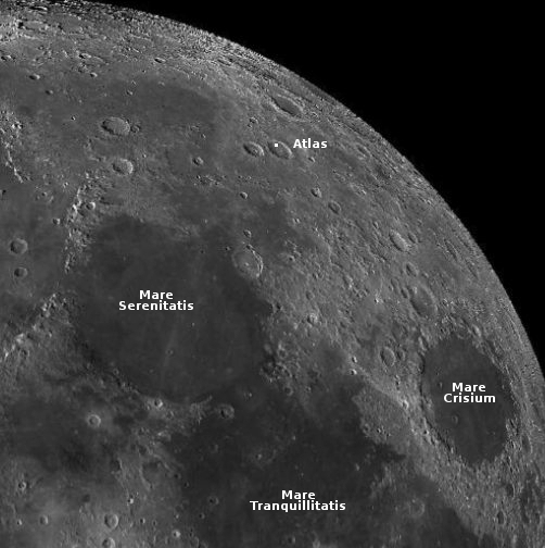
Ispace today announced that its commercial lunar lander, Hakuto-R, will now launch on a Falcon 9 rocket on November 28, 2022 and will arrive on the Moon in 54-mile-wide Atlas Crater in April 2023.
The white dot on the map to the right shows this landing spot, in the crater’s northern quadrant. Atlas is distinct in that its crater floor has many large fissures with the crater’s interior rim terraced, but this area is relatively smooth.
The spacecraft will carry seven commercial payloads, including the UAE rover Rashid, which is about the size of a small Radio Flyer wagon and will operate on the surface for about two weeks (one lunar day). It has cameras, whose primary research function will be to photograph the variety of different materials attached to the rover’s wheels to see how each interacts with the Moon’s very harsh and abrasive dust.
Rocket Factory Augsburg (RFA), one of three German rocket startups pushing to begin test launches next year, has signed a contract with Germany’s aerospace agency DLR to use of its engine test facility for static fire tests of its Helix engine.
RFA announced the deal at the Space Tech Expo Europe in Bremen, Germany, Nov. 16, which will allow RFA to use the P2.4 test site in Lampoldshausen. DLR provides the basic infrastructure while RFA brings its own test stand and supporting infrastructure.
Test stands in Lampoldshausen have so far only been used by DLR, the European Space Agency and ArianeGroup.
The new test stand will add to RFA engine testing capacity already established in Esrange in northern Sweden, where the company has been conducting testing on the Helix engine for the RFA One launcher. Testing will continue in Sweden but the new development simplifies logistics and bureaucracy related to import and export rules. [emphasis mine]
The highlighted sentence is the news. The German government has decided to break the monopoly held by government related operations of these facilities, and open up their use to private independent commercial companies.
RFA says it already has a dozen customers, and hopes to begin commercial launches by ’24.
SpaceRyde, a Canadian smallsat rocket startup company that intends to use a stratospheric balloon to act as its first stage before releasing its orbital rocket, has won a contract for four launches from ISILaunch, a Netherlands satellite company.
Customers will pay $250,000 to launch 25-kilogram payloads on SpaceRyde’s Ryder rocket and Flying Spider balloon. The flights are scheduled to begin in 2024. For the SpaceRyde flights, ISILaunch will offer customization including scheduling weeks prior to launch, access to custom orbits and various fairing configurations.
…Stratospheric balloons will serve as the first stage, lifting Ryder rockets through Earth’s atmosphere before rocket engines fire. Ryder’s upper stage, called Black Bay, is designed to remain in orbit, maneuvering and refueling as needed to provide in-orbit servicing and in-space transportation.
The first test flights are scheduled in ’23, with commercial flights starting in ’24. The company apparently is targeting the smallest smallsat market, aiming to win customers with very very low launch prices.
Shortly after SLS’s upper stage completed its engine burn to send Orion to the Moon, it separated and then successfully released ten cubesats on their own deep space missions.
These CubeSats will fly to various destinations including the Moon, asteroids, and interplanetary space. They will study various facets of the Moon and interplanetary travel, ranging from navigation techniques to radiation and biology. One of them is even planned to conduct a soft landing on the lunar surface.
Because of SLS’s numerous delays, there was a chance that many of these cubesats would lose the charges on their batteries and not function after launch. According to the article at the link, communications with six of these cubesats has been established.
The last cubesat above, from Japan and dubbed Omotenashi, was designed as a demonstration test. According to Japan’s space agency, JAXA, however, communications with the spacecraft are “unstable.”
Japan’s space agency said Thursday it has been unable to establish stable communication with the country’s mini moon lander launched on a U.S. rocket the previous day along with a mini satellite. The Japan Aerospace Exploration Agency said it is now trying to control the position of the Omotenashi lander, adding its system of automatically turning to the Sun to gain solar power appears to be not functioning.
Before launch JAXA had rated the mission’s chances of success at 60%, but that mostly referred to the lunar landing. Though intended as a demo mission, it will be unfortunate if it fails for these reasons this early in the mission.
Courtesy of Jay, BtB’s stringer.
The tweet implies the company is about to ship this to ULA for launch on the first Vulcan launch, in the spring.
It looks almost like an insulation blanket or tarp got caught there.
Apparently Rocket Lab was a subcontractor for Europe’s service module.
Cool image time! The picture to the right, rotated, cropped, reduced, and annotated to post here, was taken on August 24, 2022 by the high resolution camera on Mars Reconnaissance Orbiter (MRO). It shows glaciers apparently flowing down from two different mesas to the north and south.
The arrows indicate a major glacial stream coming from two directions. The many layered flow on the image’s upper right illustrates the many past climate cycles of Mars, with each subsequent period of snowfall and glacial growth producing progressively less ice. The chaotic region in the lower right marks what I think is the lowest point between the two mesas. Here the flows form eddies as the glaciers collide.
The overview map below shows us why there are so many glaciers at this spot on Mars.
» Read more
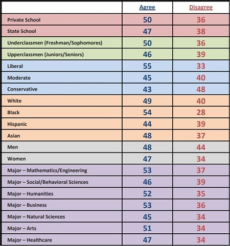
The poll numbers, across all demographics
This is no longer a land of the free: According to a new poll, half of today’s college students now believe that the death penalty is justified for some people should they dare express an opinion that offends.
Specifically, the students were asked if they agreed or disagreed with the statement:
Violence in response to offensive speech is not a new phenomenon. In some cultures, some types of offensive speech even merit the death penalty. Some speech can be so offensive in certain cases that it merits such harsh punishment.
As shown in the graph to the right, across the board, 43% to 55% of students from private and public schools, from all types of majors, from all levels of income, and from across the political spectrum, all agreed with this statement. The results were remarkably consistent. Tolerance was not their watchword, but oppression and dictatorship. If you say something that offends, half of today’s students feel justified in calling for your death.
» Read more
Using the Webb Space Telescope, astronomers have obtained a new high resolution infrared false color view of the bi-polar jets of a new solar system and star, hidden within its dark cloud of dust.
That image is the photo to the right, reduced and sharpened to post here. From the press release:
NASA’s James Webb Space Telescope has revealed the once-hidden features of the protostar within the dark cloud L1527, providing insight into the beginnings of a new star. These blazing clouds within the Taurus star-forming region are only visible in infrared light, making it an ideal target for Webb’s Near-Infrared Camera (NIRCam).
The protostar itself is hidden from view within the “neck” of this hourglass shape. An edge-on protoplanetary disk is seen as a dark line across the middle of the neck. Light from the protostar leaks above and below this disk, illuminating cavities within the surrounding gas and dust.
The region’s most prevalent features, the clouds colored blue and orange in this representative-color infrared image, outline cavities created as material shoots away from the protostar and collides with surrounding matter. The colors themselves are due to layers of dust between Webb and the clouds. The blue areas are where the dust is thinnest. The thicker the layer of dust, the less blue light is able to escape, creating pockets of orange.
Scientists estimate this star is only about 100,000 years old, and is in its earliest stage of formation. That protoplanetary disk is estimated to be about the size of our solar system.
After several months delay, the Civil Aviation Authority (CAA) in the United Kingdom yesterday issued a license to a Cornwall airport, dubbed Spaceport Cornwall, allowing Virgin Orbit to begin final preparations for the first orbital launch from within the British Isles.
The red tape however is not done.
The licence means that Virgin Orbit, which is behind the launch (named Start Me Up after the Rolling Stones song), is clear to begin to carry out mission-readiness tasks. But further licences are needed relating to this specific mission before blast-off can happen.
Melissa Thorpe, the head of Spaceport Cornwall, said: “To be the first spaceport in the UK with a licence to operate is a historic moment. Cornwall is now ready to open up the use of space for good.” She added: “The CAA continues to work on several licence applications, including being in very advanced stages with Virgin Orbit on its applications for launch and range licences, as well as the satellite operators, ahead of a proposed first UK launch.
I am reminded of the meme showing a crowd of officials surrounding one ditch digger, with the only one doing any real work that digger. It appears right now that the bureaucrats in the CAA might outnumber the staffing at both Virgin Orbit and Cornwall, and all they have to do is issue a piece of paper.
Capitalism in space: NASA yesterday modified its manned lunar lander contract with SpaceX to award Starship a second manned lunar landing for $1.15 billion.
Known as Option B, the modification follows an award to SpaceX in July 2021 under the Next Space Technologies for Exploration Partnerships-2 (NextSTEP-2) Appendix H Option A contract. NASA previously announced plans to pursue this Option B with SpaceX. The contract modification has a value of about $1.15 billion.
…The aim of this new work under Option B is to develop and demonstrate a Starship lunar lander that meets NASA’s sustaining requirements for missions beyond Artemis III, including docking with Gateway, accommodating four crew members, and delivering more mass to the surface.
NASA is also accepting bids for a competitive second manned lunar lander, but has awarded nothing as yet.
Combined with earlier investments and contracts, SpaceX now had garnered about $13 billion for developing Starship and Starlink, about $9 billion from private investment capital and about $4 billion from NASA, with most of the cash used for Starship. In addition, the company plans another investment funding round that will raise its valuation to $150 billion.
SLS might have flown once, but it appears both NASA and the investment community is increasingly putting its eggs in the Starship basket.
The Chinese pseudo-company Galactic Energy today used its Ceres-1 rocket to put five Earth observations satellites into orbit.
According to China’s state run press, Ceres-1 is a “small-scale solid-propellant carrier rocket capable of sending micro-satellites into low-Earth orbit.” In other words, it was developed initially by the military for missile use, and the government has allowed it to be upgraded for civilian use.
The leaders in the 2022 launch race:
52 SpaceX
52 China
19 Russia
9 Rocket Lab
8 ULA
The U.S. still leads China 76 to 52 in the national rankings, but trails the rest of the world combined 80 to 76.
The 52 launches by China ties its yearly record, set last year, for the most successful launches in a single year. Like the U.S. China appears set to smash its launch record in 2022.
The uncertainty of science: According to a paper published at the end of October, scientists have used data from the LADEE lunar orbiter (that circled the Moon in 2013-2014) and found that the surface of the Moon is extremely arid, and if there is any ice trapped in the permanently shadowed craters at the poles it did not come from meteorite impacts elsewhere on the Moon. From the abstract:
The upper bound for exospheric water derived here from data collected in 2013–2014 by the neutral mass spectrometer on the Lunar Atmosphere and Dust Environment Explorer spacecraft [LADEE], about three molecules/cc, pales in comparison to the concentration of ∼15,000 molecules/cc needed to sequester the meteoritic water influx. The only pragmatic conclusion is that the hypothesis for water ice accumulation at the poles due to exospheric transport is false.
The theory had been that any water from these meteorites could have been transported by various processes to the polar cold traps. This data says that did not happen, and if there is water ice in the polar cold traps, its origin remains unknown, though comet impacts at the poles might have been a source.
This result also appears to contradict other orbital data that has suggested there is some water in the lunar regolith at mid and low latitudes.
After almost eighteen years of development and almost sixty billion dollars, NASA tonight finally completed the first unmanned test launch of its Space Launch System (SLS) rocket, lifting off at 1:41 am (Eastern).
The two solid rocket boosters functioned as planned, separating from the core stage with no problem. Then core stage and its four former shuttle engines completed its burn, putting the capsule and its upper stage into Earth orbit, and then separated cleanly. At about 30 minutes after launch the service module’s solar arrays completed their deployment. At 53 minutes after launch a 30 second burn circularized the orbit in preparation for the trans-lunar-injection (TLI) burn that will send Orion to the Moon. TLI occurred about 90 minutes after launch, after a period of check-out in orbit.
Orion will spend 26 days in space, about a week of which will be in a wide lunar orbit, testing its systems. If all goes right it will splashdown on around December 11th.
As this was the first U.S. government launch in more than a decade, since 2011 when the space shuttle was retired, the leader board for the 2022 launch race remains unchanged:
The leaders in the 2022 launch race:
52 SpaceX
51 China
19 Russia
9 Rocket Lab
8 ULA
The U.S. now leads China 76 to 51 in the national rankings, and trails the rest of the world combined 79 to 76.
Embedded below the fold in two parts.
To listen to all of John Batchelor’s podcasts, go here.
» Read more