A patch of chaos in the Martian cratered southern highlands
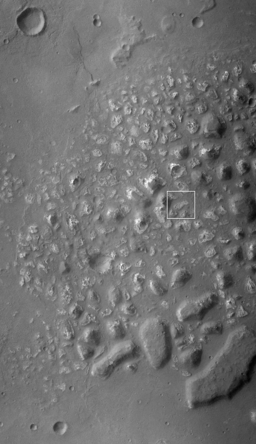
Today’s cool image, rotated, cropped, and reduced to post here, takes us to the cratered southern highlands of Mars. Taken by the context wide angle camera on Mars Reconnaissance Orbiter, this image shows us a strange isolated patch of what appears to be chaos terrain, which on Mars generally means an area of random knobs and mesas cut by canyons and channels.
The large bulk of chaos terrain on Mars is found near or in the transition zone between the lowland northern plains and the southern cratered highlands, and is thought to have been created by slow erosion, possibly by glaciers. This erosion process is aided by the gradient downhill from those highlands to the lowlands.
This location however is in the middle of the cratered highlands, and shows no obvious slope in any direction. And though the location is in the mid-southern latitudes, there is no obvious evidence of glaciers among these knobs and mesas. Furthermore, the mesas are not all the same height. Instead, a large portion appear to have been shaved off, as if some giant came in with a putty knife and scrapped away at them.
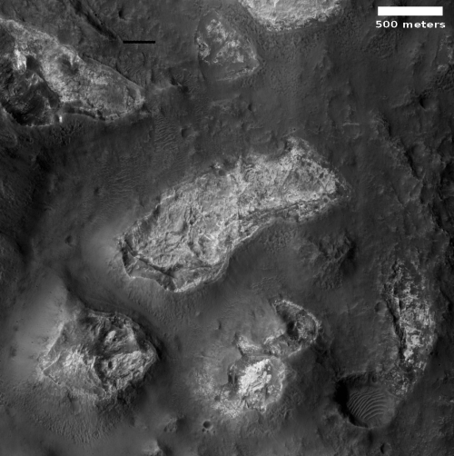
This can be clearly seen by the close-up below, taken by MRO’s high resolution camera on July 16, 2002 of the area indicated by the white box, which for scale is about 2 1/4 miles square.
The mesa in the lower left of the photo to the right clearly stands above the surrounding terrain. Yet its top seems badly eroded. The other mesas in the image meanwhile all seem even more eroded, with some appearing almost level with the surrounding terrain. The plateaus of all are bright, and appear very rough when compared to the plains below.
What caused the erosion? Why are the mesa tops bright, and why do there appear to be depressions within many mesa tops?
Scientists have obviously been asking some of these questions, as they have used MRO to take a number of high resolution images of this patch of chaos (see here, here, here, here, here, and here).

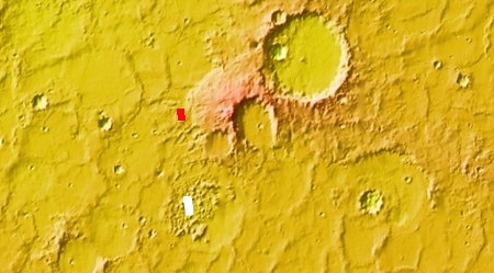
We can get a clue of what causes this patch of chaos by taking a wider look. The white rectangle in the overview map to the right is where today’s close-up hi-res image is located. The red box is of a high resolution image of a crater about 50 miles to the north, taken on August 20, 2016. The floor of that crater appears to have glacial features, reinforced by the gullies on its northern interior rim with a pile of debris at their base. Moreover, this crater is at the base of a large lobate flow descending from the rims of the larger craters to the east.
All suggest (but do not prove) that glaciers are present in this region, and might have once been more extensive. If so, then it is possible that in a previous epoch glaciers had reached this chaos terrain, and had carved it out as it appears such glacial activity is doing in the chaos terrain in the transition zone between the northern lowlands and southern highlands.
The ebb and flow of those glaciers across different Martian climate cycles could have later caused the erosion that scrapped off many of these mesas.
Sounds good, eh? Not really. This is only a hypothesis, based on very limited data, and thus should never be taken very seriously. More data might reveal a completely different solution for explaining these strange mesas.
All we really know at this point is that Mars has strange geology that does not really correspond to what we are used to here on Earth.
On Christmas Eve 1968 three Americans became the first humans to visit another world. What they did to celebrate was unexpected and profound, and will be remembered throughout all human history. Genesis: the Story of Apollo 8, Robert Zimmerman's classic history of humanity's first journey to another world, tells that story, and it is now available as both an ebook and an audiobook, both with a foreword by Valerie Anders and a new introduction by Robert Zimmerman.
The print edition can be purchased at Amazon or from any other book seller. If you want an autographed copy the price is $60 for the hardback and $45 for the paperback, plus $8 shipping for each. Go here for purchasing details. The ebook is available everywhere for $5.99 (before discount) at amazon, or direct from my ebook publisher, ebookit. If you buy it from ebookit you don't support the big tech companies and the author gets a bigger cut much sooner.
The audiobook is also available at all these vendors, and is also free with a 30-day trial membership to Audible.
"Not simply about one mission, [Genesis] is also the history of America's quest for the moon... Zimmerman has done a masterful job of tying disparate events together into a solid account of one of America's greatest human triumphs."--San Antonio Express-News
Today’s cool image, rotated, cropped, and reduced to post here, takes us to the cratered southern highlands of Mars. Taken by the context wide angle camera on Mars Reconnaissance Orbiter, this image shows us a strange isolated patch of what appears to be chaos terrain, which on Mars generally means an area of random knobs and mesas cut by canyons and channels.
The large bulk of chaos terrain on Mars is found near or in the transition zone between the lowland northern plains and the southern cratered highlands, and is thought to have been created by slow erosion, possibly by glaciers. This erosion process is aided by the gradient downhill from those highlands to the lowlands.
This location however is in the middle of the cratered highlands, and shows no obvious slope in any direction. And though the location is in the mid-southern latitudes, there is no obvious evidence of glaciers among these knobs and mesas. Furthermore, the mesas are not all the same height. Instead, a large portion appear to have been shaved off, as if some giant came in with a putty knife and scrapped away at them.
This can be clearly seen by the close-up below, taken by MRO’s high resolution camera on July 16, 2002 of the area indicated by the white box, which for scale is about 2 1/4 miles square.
The mesa in the lower left of the photo to the right clearly stands above the surrounding terrain. Yet its top seems badly eroded. The other mesas in the image meanwhile all seem even more eroded, with some appearing almost level with the surrounding terrain. The plateaus of all are bright, and appear very rough when compared to the plains below.
What caused the erosion? Why are the mesa tops bright, and why do there appear to be depressions within many mesa tops?
Scientists have obviously been asking some of these questions, as they have used MRO to take a number of high resolution images of this patch of chaos (see here, here, here, here, here, and here).

We can get a clue of what causes this patch of chaos by taking a wider look. The white rectangle in the overview map to the right is where today’s close-up hi-res image is located. The red box is of a high resolution image of a crater about 50 miles to the north, taken on August 20, 2016. The floor of that crater appears to have glacial features, reinforced by the gullies on its northern interior rim with a pile of debris at their base. Moreover, this crater is at the base of a large lobate flow descending from the rims of the larger craters to the east.
All suggest (but do not prove) that glaciers are present in this region, and might have once been more extensive. If so, then it is possible that in a previous epoch glaciers had reached this chaos terrain, and had carved it out as it appears such glacial activity is doing in the chaos terrain in the transition zone between the northern lowlands and southern highlands.
The ebb and flow of those glaciers across different Martian climate cycles could have later caused the erosion that scrapped off many of these mesas.
Sounds good, eh? Not really. This is only a hypothesis, based on very limited data, and thus should never be taken very seriously. More data might reveal a completely different solution for explaining these strange mesas.
All we really know at this point is that Mars has strange geology that does not really correspond to what we are used to here on Earth.
On Christmas Eve 1968 three Americans became the first humans to visit another world. What they did to celebrate was unexpected and profound, and will be remembered throughout all human history. Genesis: the Story of Apollo 8, Robert Zimmerman's classic history of humanity's first journey to another world, tells that story, and it is now available as both an ebook and an audiobook, both with a foreword by Valerie Anders and a new introduction by Robert Zimmerman.
The print edition can be purchased at Amazon or from any other book seller. If you want an autographed copy the price is $60 for the hardback and $45 for the paperback, plus $8 shipping for each. Go here for purchasing details. The ebook is available everywhere for $5.99 (before discount) at amazon, or direct from my ebook publisher, ebookit. If you buy it from ebookit you don't support the big tech companies and the author gets a bigger cut much sooner.
The audiobook is also available at all these vendors, and is also free with a 30-day trial membership to Audible.
"Not simply about one mission, [Genesis] is also the history of America's quest for the moon... Zimmerman has done a masterful job of tying disparate events together into a solid account of one of America's greatest human triumphs."--San Antonio Express-News


So the geological history of Mars was never a ‘wet Mars’ but may have always been (and still is) a ‘glacial Mars’? The evidence of water based formation of some rocks, could that have been from water trapped at the base of some glaciers?
Brad: In a word, yes. The evidence is increasingly pointing to a glacial Mars.
Do a search on BtB for “Mars” and “glaciers”. You will get a lot of good readings on what is being learned. Lots of cool images too!
Brad: If you want to get the background quicker, note that in this post as well as all my posts, I provide links within to important previous BtB articles on the subject. The links under the words “chaos terrain” and “such glacial activity is doing” in this particular article cover important aspects of this geology, and both include links to further past articles.