Another “What the heck?!” image on Mars
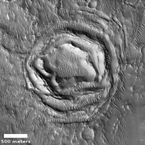
Today’s cool image, taken on September 2, 2020 by the high resolution camera on Mars Reconnaissance Orbiter (MRO) and cropped and reduced to post here, is one that I will make very little attempt to explain. It falls into a category I call “What the heck?!” The uncaptioned website labels this “Ringed Ridges in Kasei Valles”, which merely describes what we see.
This isn’t an impact crater. The rings don’t fit any morphology I’ve ever seen for such features.
Could we be looking at some type of glacial feature? The latitude, 29 degrees north, makes this unlikely but possible. Even so, it sure doesn’t look like it. The ripples in the center and between the ridges are sand dunes, not glacial features.
Might this be a volcanic vent, with the concentric ridges marking multiple eruptions? Maybe, but if so I’ve never seen any volcanic vent or caldera that looked quite like this.
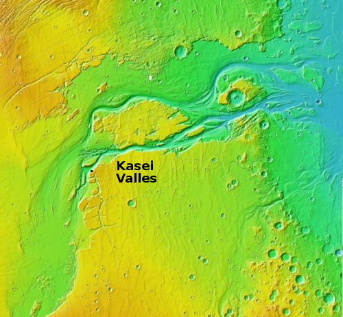
The overview map below gives some context, but hardly explains anything.

The white box north of the main channels of Kasei Valles marks the location of this strange feature.
The one major driving geological process that is thought to have shaped the Kasei Valley is that of one or more catastrophic floods, over many millions of years. One hypothesis [pdf] even suggests a large ice dam had formed across the canyon just before it turns east, creating a large lake that when the dam broke rushed eastward, creating the canyon’s braided channels.
Unfortunately, I can’t reconcile such floods with the strange concentric ridges above. The rings just don’t seem to have been formed or even reshaped by a catastrophic flood.
So what made this? While I suppose volcanism is the best guess, it is not one I have much enthusiasm for. My readers are welcome to make their own guesses, but I guarantee we will all be likely wrong in some manner.
On Christmas Eve 1968 three Americans became the first humans to visit another world. What they did to celebrate was unexpected and profound, and will be remembered throughout all human history. Genesis: the Story of Apollo 8, Robert Zimmerman's classic history of humanity's first journey to another world, tells that story, and it is now available as both an ebook and an audiobook, both with a foreword by Valerie Anders and a new introduction by Robert Zimmerman.
The print edition can be purchased at Amazon or from any other book seller. If you want an autographed copy the price is $60 for the hardback and $45 for the paperback, plus $8 shipping for each. Go here for purchasing details. The ebook is available everywhere for $5.99 (before discount) at amazon, or direct from my ebook publisher, ebookit. If you buy it from ebookit you don't support the big tech companies and the author gets a bigger cut much sooner.
The audiobook is also available at all these vendors, and is also free with a 30-day trial membership to Audible.
"Not simply about one mission, [Genesis] is also the history of America's quest for the moon... Zimmerman has done a masterful job of tying disparate events together into a solid account of one of America's greatest human triumphs."--San Antonio Express-News
Today’s cool image, taken on September 2, 2020 by the high resolution camera on Mars Reconnaissance Orbiter (MRO) and cropped and reduced to post here, is one that I will make very little attempt to explain. It falls into a category I call “What the heck?!” The uncaptioned website labels this “Ringed Ridges in Kasei Valles”, which merely describes what we see.
This isn’t an impact crater. The rings don’t fit any morphology I’ve ever seen for such features.
Could we be looking at some type of glacial feature? The latitude, 29 degrees north, makes this unlikely but possible. Even so, it sure doesn’t look like it. The ripples in the center and between the ridges are sand dunes, not glacial features.
Might this be a volcanic vent, with the concentric ridges marking multiple eruptions? Maybe, but if so I’ve never seen any volcanic vent or caldera that looked quite like this.
The overview map below gives some context, but hardly explains anything.

The white box north of the main channels of Kasei Valles marks the location of this strange feature.
The one major driving geological process that is thought to have shaped the Kasei Valley is that of one or more catastrophic floods, over many millions of years. One hypothesis [pdf] even suggests a large ice dam had formed across the canyon just before it turns east, creating a large lake that when the dam broke rushed eastward, creating the canyon’s braided channels.
Unfortunately, I can’t reconcile such floods with the strange concentric ridges above. The rings just don’t seem to have been formed or even reshaped by a catastrophic flood.
So what made this? While I suppose volcanism is the best guess, it is not one I have much enthusiasm for. My readers are welcome to make their own guesses, but I guarantee we will all be likely wrong in some manner.
On Christmas Eve 1968 three Americans became the first humans to visit another world. What they did to celebrate was unexpected and profound, and will be remembered throughout all human history. Genesis: the Story of Apollo 8, Robert Zimmerman's classic history of humanity's first journey to another world, tells that story, and it is now available as both an ebook and an audiobook, both with a foreword by Valerie Anders and a new introduction by Robert Zimmerman.
The print edition can be purchased at Amazon or from any other book seller. If you want an autographed copy the price is $60 for the hardback and $45 for the paperback, plus $8 shipping for each. Go here for purchasing details. The ebook is available everywhere for $5.99 (before discount) at amazon, or direct from my ebook publisher, ebookit. If you buy it from ebookit you don't support the big tech companies and the author gets a bigger cut much sooner.
The audiobook is also available at all these vendors, and is also free with a 30-day trial membership to Audible.
"Not simply about one mission, [Genesis] is also the history of America's quest for the moon... Zimmerman has done a masterful job of tying disparate events together into a solid account of one of America's greatest human triumphs."--San Antonio Express-News


Robert, I think it must be a much eroded & sand-covered volcanic remnant. Take a look on Google Earth at the lower left corner of Egypt where it borders Libya – definitely ancient rocky caldera & not dissimilar in shape.
As you said… probably wrong!
Wormsign…the spice must flow!
What the heck, indeed.
If I didn’t know better, I’d advise whoever it was to see a dermatologist.
It reminds me of a mud volcano….. although I cannot really think of how a mud volcano could form, as this area once was almost definatly wet in the past, perhaps there is some possible geological process?
It reminds me of the way ice forms over a spring in a lake. The center would be the last to freeze with the water pushing up. Maybe it formed in the past and is now covered with sand.
About 1500m from the center of the “feature” at a bearing of ~45 degrees relative to the top of the page is an additional curious feature. I see a structure that is roughly “U” shaped with sharply defined ~95 degree angles off of the base. What geological processes could produce such a structure?
Allen: First, we should mention to the readers that this feature is visible in the full image, not in the cropped photo I featured.
Second, my guess is that we are looking at three depressions produced by faults. The ground is cracked, and material sinks at the breaks.
It is not unusual to see depressions with sharp angles like this on either Mars or Earth. There is even a geological term for them, dubbed grabens.
I should add that these cracks suggest again that the central ringed structure is volcanic. As it pushed upward, it cracked the ground around it.
It might have started as a Maar type eruption with ice dunes freezing into place with wind building up the rim-maybe seiche slosh and some creep too?