Glaciers and mesas on Mars

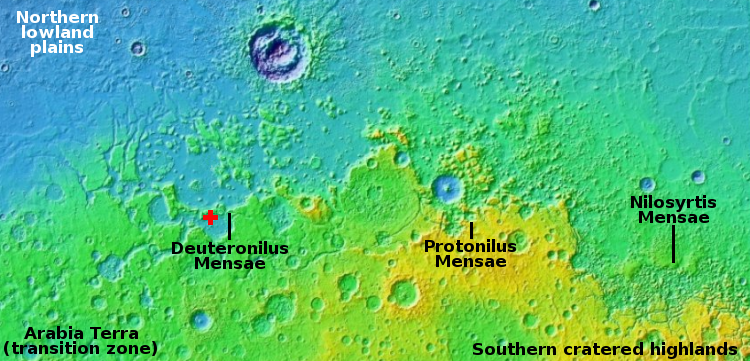
Cool image time! Today we return to glacier country on Mars, that band of mensae mesas and glaciers that stretches more than 2,000 miles in the northern mid-latitudes, as shown on the overview map above.
No rovers or landers have yet visited this region, nor are any planned. To the west just beyond the map’s left edge is the planned landing site of Europe’s Franklin rover. To the east and south and just beyond the map’s right edge is where America’s Perseverance rover presently travels in Jezero Crater.
Our journey today begins from afar, and will steadily zoom into the area of the red cross and a most intriguing feature seen in a recent picture taken by the high resolution camera on Mars Reconnaissance Orbiter (MRO).
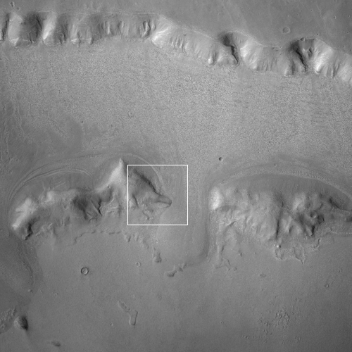
Before we look at that high resolution image, it is better to view the area using MRO’s context camera, as what it shows helps make sense of the features in the close-up.
To the right is that context camera photograph, taken August 1, 2012 and rotated, cropped, and reduced to post here. The white box marks the area covered by the high resolution image below. As this wide image shows, the grade is downhill to the south, with the valley between the northernmost cliff and the line of mesas to the south apparently filled with glacial material, so much so that the glaciers have pushed their way through several gaps in that line of mesas.
Such glacial features are quite common in this part of Mars. Practically every image taken in this region shows such features, which means any future colonists will merely have to do some mining and processing of the ice to obtain all the water they need.
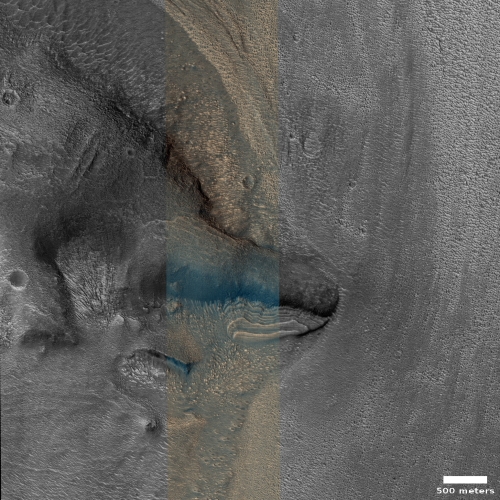
The high resolution image, rotated, cropped, and reduced, was taken on May 10, 2021. The photo title, “Irregular Block near Glacier-Like Form,” suggests the goal was to inspect that spot where the narrow mesa wall acted as a barrier and forced the glacier around it.
Note the colors in the color strip. The dark blue areas are likely coarse sand and rocks. The brighter reddish and orange probably represents dust. Thus, while this glacial-like feature might be water ice, that ice is covered by a layer of protective material that prevents the ice from sublimating away. Moreover, it is presently thought that these glaciers are inactive, as they have over time shown no signs of motion to the south.
What I find most intriguing however are the terraced glacier features just south of this mesa barrier. While the downhill grade is to the south, these terraces instead descend to the north. My guess is that they represent some kind of leftover eddy produced when the glacier was flowing to the south, with the terraces representing different geological epochs where new layers were being placed on the glacier.
But then, that is a guess. You would have to do a lot more research, some of it on Mars, to get a more reliable hypothesis.
On Christmas Eve 1968 three Americans became the first humans to visit another world. What they did to celebrate was unexpected and profound, and will be remembered throughout all human history. Genesis: the Story of Apollo 8, Robert Zimmerman's classic history of humanity's first journey to another world, tells that story, and it is now available as both an ebook and an audiobook, both with a foreword by Valerie Anders and a new introduction by Robert Zimmerman.
The print edition can be purchased at Amazon or from any other book seller. If you want an autographed copy the price is $60 for the hardback and $45 for the paperback, plus $8 shipping for each. Go here for purchasing details. The ebook is available everywhere for $5.99 (before discount) at amazon, or direct from my ebook publisher, ebookit. If you buy it from ebookit you don't support the big tech companies and the author gets a bigger cut much sooner.
The audiobook is also available at all these vendors, and is also free with a 30-day trial membership to Audible.
"Not simply about one mission, [Genesis] is also the history of America's quest for the moon... Zimmerman has done a masterful job of tying disparate events together into a solid account of one of America's greatest human triumphs."--San Antonio Express-News


Curious if an inactive glacier, can actually be called a glacier? The definition is “A glacier is a persistent body of dense ice that is constantly moving under its own weight. If it’s not moving, it doesn’t seem to be a glacier. Maybe, a ‘stacier’?
Presumably, glaciers have a lifecycle. After all, the “pile of snow and ice” doesn’t start out as a glacier. It takes some time to form. A proto-glacier? Or considering where this line of thought is going, an ante-glacier. After its life as a glacier-glacier, it becomes a post-glacier when it is not replenished at the “headspring” sufficiently to keep moving, which may or may not involve melting (or sublimating) away.
Surely people who study these things have words for all of this. There must be more of these ante/post glacial things than drag racing engines with cylinder ignition problems and we have a word for that.
If we need the water to breath, generate energy and produce fuel, why aren’t rovers investigating areas like this? Is it that there aren’t caves to protect humans from cosmic rays?
Gary H: I have actually answered your question in many of my cool image posts. The guidance we are using for where we send rovers today is entirely controlled by scientific concerns. The needs of future colonies is not the prime or even a driving force.
Eventually, as private concerns (such as SpaceX) get closer to launching their own missions, they will send out their own unmanned scouts to study exactly the issues you raise. I for one have already suggested one particular cave on Mars that merits further exploration prior to manned missions.