Glaciers or taffy on Mars?
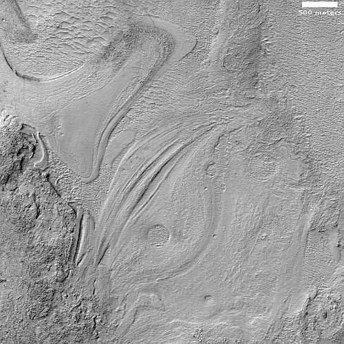
Cool image time! The photo to the right, rotated, cropped, reduced, and sharpened to post here, was taken on November 28, 2022 by the high resolution camera on Mars Reconnaissance Orbiter (MRO). It was released on January 4, 2023 as a captioned image, with this caption by Alfred McEwen of the Lunar & Planetary Laboratory in Arizona:
The floor of the Hellas impact basin, the lowest elevation on Mars, remains poorly explored because haze often blocks it from view. However, we recently got a clear image, revealing the strange banded terrain. These bands may be layers or flow bands or both.
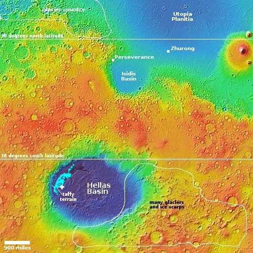
At first glance, these bands reminded me of the many glaciers found on Mars. McEwen however is being properly vague about the nature of these features, for a number of reasons illustrated by the overview map below.

The white cross inside Hellas Basin marks the location of today’s image. The location, on the edge of a region where scientists find an inexplicable and unique Martian feature they dub taffy terrain, is at 41 degrees south latitude, well inside the mid-latitude bands where scientists have found many glacial features. However, few such glacial features have been found inside Hellas, which has generally been attributed to its low elevation. McEwen’s comment about the lack of good imagery due to haze might also be an explanation, and thus this image might suggest that glaciers will be found here as well, when enough good pictures are taken.
The bands however could simply be another example of taffy terrain, which is generally found in the deepest sections of Hellas, a curved trough that parallels the basin’s western perimeter. As noted in this 2014 paper:
The apparent sensitivity to local topography and preference for concentrating in localized depressions is compatible with deformation as a viscous fluid.
What that viscous fluid is remains an object of debate. Based on crater counts, the taffy terrain is generally thought to be about 3 billion years old, which argues against it being glacial ice. At the same time, the 2014 paper considers it possible it is very old ice heavily weathered due to wind over eons.
Then again, maybe it is taffy, pulled into these shapes by some giant Martian.
On Christmas Eve 1968 three Americans became the first humans to visit another world. What they did to celebrate was unexpected and profound, and will be remembered throughout all human history. Genesis: the Story of Apollo 8, Robert Zimmerman's classic history of humanity's first journey to another world, tells that story, and it is now available as both an ebook and an audiobook, both with a foreword by Valerie Anders and a new introduction by Robert Zimmerman.
The print edition can be purchased at Amazon or from any other book seller. If you want an autographed copy the price is $60 for the hardback and $45 for the paperback, plus $8 shipping for each. Go here for purchasing details. The ebook is available everywhere for $5.99 (before discount) at amazon, or direct from my ebook publisher, ebookit. If you buy it from ebookit you don't support the big tech companies and the author gets a bigger cut much sooner.
The audiobook is also available at all these vendors, and is also free with a 30-day trial membership to Audible.
"Not simply about one mission, [Genesis] is also the history of America's quest for the moon... Zimmerman has done a masterful job of tying disparate events together into a solid account of one of America's greatest human triumphs."--San Antonio Express-News
Cool image time! The photo to the right, rotated, cropped, reduced, and sharpened to post here, was taken on November 28, 2022 by the high resolution camera on Mars Reconnaissance Orbiter (MRO). It was released on January 4, 2023 as a captioned image, with this caption by Alfred McEwen of the Lunar & Planetary Laboratory in Arizona:
The floor of the Hellas impact basin, the lowest elevation on Mars, remains poorly explored because haze often blocks it from view. However, we recently got a clear image, revealing the strange banded terrain. These bands may be layers or flow bands or both.
At first glance, these bands reminded me of the many glaciers found on Mars. McEwen however is being properly vague about the nature of these features, for a number of reasons illustrated by the overview map below.

The white cross inside Hellas Basin marks the location of today’s image. The location, on the edge of a region where scientists find an inexplicable and unique Martian feature they dub taffy terrain, is at 41 degrees south latitude, well inside the mid-latitude bands where scientists have found many glacial features. However, few such glacial features have been found inside Hellas, which has generally been attributed to its low elevation. McEwen’s comment about the lack of good imagery due to haze might also be an explanation, and thus this image might suggest that glaciers will be found here as well, when enough good pictures are taken.
The bands however could simply be another example of taffy terrain, which is generally found in the deepest sections of Hellas, a curved trough that parallels the basin’s western perimeter. As noted in this 2014 paper:
The apparent sensitivity to local topography and preference for concentrating in localized depressions is compatible with deformation as a viscous fluid.
What that viscous fluid is remains an object of debate. Based on crater counts, the taffy terrain is generally thought to be about 3 billion years old, which argues against it being glacial ice. At the same time, the 2014 paper considers it possible it is very old ice heavily weathered due to wind over eons.
Then again, maybe it is taffy, pulled into these shapes by some giant Martian.
On Christmas Eve 1968 three Americans became the first humans to visit another world. What they did to celebrate was unexpected and profound, and will be remembered throughout all human history. Genesis: the Story of Apollo 8, Robert Zimmerman's classic history of humanity's first journey to another world, tells that story, and it is now available as both an ebook and an audiobook, both with a foreword by Valerie Anders and a new introduction by Robert Zimmerman.
The print edition can be purchased at Amazon or from any other book seller. If you want an autographed copy the price is $60 for the hardback and $45 for the paperback, plus $8 shipping for each. Go here for purchasing details. The ebook is available everywhere for $5.99 (before discount) at amazon, or direct from my ebook publisher, ebookit. If you buy it from ebookit you don't support the big tech companies and the author gets a bigger cut much sooner.
The audiobook is also available at all these vendors, and is also free with a 30-day trial membership to Audible.
"Not simply about one mission, [Genesis] is also the history of America's quest for the moon... Zimmerman has done a masterful job of tying disparate events together into a solid account of one of America's greatest human triumphs."--San Antonio Express-News


Wonderful picture, best clear evidence for viscous fluid i.e. liquid saturated soil pushed into a mud flow before freezing into a glacier.(higher air pressure allows liquid water, without boiling and evaporating away, at the lowest point on Mars) At the end of the large flow it’s very rough, similar to what I’ve seen on Yukon River in the spring when the ice breaks up and creates “ice dams”. Thick surface ice that piles up reaching dozens of feet high at times, causing Yukon water to flow up and around until pressure lifts and breaks it up again. (The lower Yukon is wide, but very slow and shallow)
Every house in the villages near the river has thick log Posts in front of their house to prevent ice from destroying their homes when the water is forced outside of its banks.
Although this is more likely the remnant of mud ice, that froze on the surface as it flowed towards the end, and then fresh mud, from deep in the flow still warm and fluid, has irrupted to the side, being very smooth before freezing. A second flow much smaller nearby flowing down from the right of the picture, has similar evidence of being frozen on the top and then suddenly irrupting from under the tip of the ice dam that is rough, with a flow that froze very smooth. But then, lava on the slopes of the volcanoes look similar.
Other details like dust devil trails across the landscape, and a few dark spots that appeared to be windows and cracks in the ice with darkness in the cracks that could be very deep or vents. One window has a trail leading out of it like it had water flowing.
The deep trench in the middle of a flow in lower left is curious, perhaps the center was filled with liquid water leaving a water “lake” depression before it all froze and evaporated away leaving the bowl shape trench behind?
Couldn’t find Waldo…