More great hiking on Mars
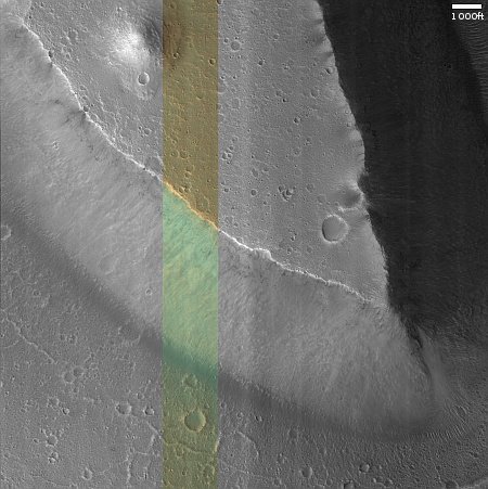
Today’s cool image takes us to another place on Mars where future colonizers will find the hiking breath-taking. The picture to the right, rotated, cropped, reduced, and sharpened to post here, was taken on April 18, 2024 by the high resolution camera on Mars Reconnaissance Orbiter (MRO). The camera team labeled it merely as a “terrain sample,” indicating it was not taken as part of any specific research project request, but to fill a gap in the schedule in order to maintain the camera’s proper temperature. When the MRO team does this, they try to pick interesting sites, sometimes successfully, sometimes not.
In this case the image captured the sharp nose of a 2,100-foot-high mesa which to my eye immedately said, “I want to hike a trail that switchbacks up that nose!” Ideally, the trail would then skirt the edge of the mesa, then head up to the top of that small knoll on the plateau. Though only another 200 feet higher or so, the peak would provide an amazing 360 degree view of the surrounding terrrain.

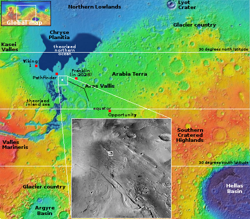
On the overview map to the right, the white dot at the outlet of the 900-mile-long Ares Valles channel marks the location of this mesa, about 150 miles southeast from where Mars Pathfinder landed in 1997. At this point the channel is about 60 miles wide, and the mesa sits almost exactly in its middle. Initially the formation of Ares was believed to have been caused by catastrophic floods, but newer research suggests instead the slow motion of giant glaciers might have played a part. Whatever carved this long canyon however hit the mesa at this point and was diverted to either side.
The views would be spectacular, but remarkable barren at the same time. Unlike Earth, the landscape of Mars shows no visible life at all, and in most places the colors are confined to range of orange to red.
On Christmas Eve 1968 three Americans became the first humans to visit another world. What they did to celebrate was unexpected and profound, and will be remembered throughout all human history. Genesis: the Story of Apollo 8, Robert Zimmerman's classic history of humanity's first journey to another world, tells that story, and it is now available as both an ebook and an audiobook, both with a foreword by Valerie Anders and a new introduction by Robert Zimmerman.
The print edition can be purchased at Amazon or from any other book seller. If you want an autographed copy the price is $60 for the hardback and $45 for the paperback, plus $8 shipping for each. Go here for purchasing details. The ebook is available everywhere for $5.99 (before discount) at amazon, or direct from my ebook publisher, ebookit. If you buy it from ebookit you don't support the big tech companies and the author gets a bigger cut much sooner.
The audiobook is also available at all these vendors, and is also free with a 30-day trial membership to Audible.
"Not simply about one mission, [Genesis] is also the history of America's quest for the moon... Zimmerman has done a masterful job of tying disparate events together into a solid account of one of America's greatest human triumphs."--San Antonio Express-News
Today’s cool image takes us to another place on Mars where future colonizers will find the hiking breath-taking. The picture to the right, rotated, cropped, reduced, and sharpened to post here, was taken on April 18, 2024 by the high resolution camera on Mars Reconnaissance Orbiter (MRO). The camera team labeled it merely as a “terrain sample,” indicating it was not taken as part of any specific research project request, but to fill a gap in the schedule in order to maintain the camera’s proper temperature. When the MRO team does this, they try to pick interesting sites, sometimes successfully, sometimes not.
In this case the image captured the sharp nose of a 2,100-foot-high mesa which to my eye immedately said, “I want to hike a trail that switchbacks up that nose!” Ideally, the trail would then skirt the edge of the mesa, then head up to the top of that small knoll on the plateau. Though only another 200 feet higher or so, the peak would provide an amazing 360 degree view of the surrounding terrrain.

On the overview map to the right, the white dot at the outlet of the 900-mile-long Ares Valles channel marks the location of this mesa, about 150 miles southeast from where Mars Pathfinder landed in 1997. At this point the channel is about 60 miles wide, and the mesa sits almost exactly in its middle. Initially the formation of Ares was believed to have been caused by catastrophic floods, but newer research suggests instead the slow motion of giant glaciers might have played a part. Whatever carved this long canyon however hit the mesa at this point and was diverted to either side.
The views would be spectacular, but remarkable barren at the same time. Unlike Earth, the landscape of Mars shows no visible life at all, and in most places the colors are confined to range of orange to red.
On Christmas Eve 1968 three Americans became the first humans to visit another world. What they did to celebrate was unexpected and profound, and will be remembered throughout all human history. Genesis: the Story of Apollo 8, Robert Zimmerman's classic history of humanity's first journey to another world, tells that story, and it is now available as both an ebook and an audiobook, both with a foreword by Valerie Anders and a new introduction by Robert Zimmerman.
The print edition can be purchased at Amazon or from any other book seller. If you want an autographed copy the price is $60 for the hardback and $45 for the paperback, plus $8 shipping for each. Go here for purchasing details. The ebook is available everywhere for $5.99 (before discount) at amazon, or direct from my ebook publisher, ebookit. If you buy it from ebookit you don't support the big tech companies and the author gets a bigger cut much sooner.
The audiobook is also available at all these vendors, and is also free with a 30-day trial membership to Audible.
"Not simply about one mission, [Genesis] is also the history of America's quest for the moon... Zimmerman has done a masterful job of tying disparate events together into a solid account of one of America's greatest human triumphs."--San Antonio Express-News


“I want to hike a trail that switchbacks up that nose!”
I have fun memories of hiking the Grand Canyon, and other state and national parks… but let’s examine the differences on Mars?
On the good side you’ll be hiking in 1/3 gravity.
But you’ll be in a space suit, carrying your oxygen, in temperatures that are far below freezing. The dirt will be soft, but the rocks sharp.
Also the view would be spectacular from such a height, but the dusty horizon at ground level is about 2 to 3 miles. (Mars is 1/2 the circumference of earth)
It appears the Mesa tapers off into the Delta… An easy drive for a vehicle to meet you on top to replenish your oxygen before you attempt hang gliding back to the bottom on the almost nonexistent air currents.
I would rather just drive a fast dune buggy across the planet. Electric of course and modified for the environment.
We can have a Mars 500 km race.
Does anybody know what the colored band running through the picture is for? We see it in many of the Mars Reconnaissance Orbiter pictures?
Marcy: The color band is from MRO’s color filters. As I understand it (though I might not be entirely accurate here) the higher data requirements for color limits it to only this single band for each picture.
A problem with one of MRO’s filters now leaves this strip blank in the black & white image (see here), so the camera team now fills it in routinely with the color strip.