
Scientists issue new map of land below Antarctica’s icecap
Click for original image.
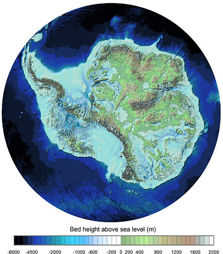
Using decades of data and more advanced computer software, scientists have now compiled the most detailed map of the land and shorelines hidden below Antarctica’s massive icecap.
The map to the right, reduced to post here, shows that bedrock terrain generally in hues of green to brown, with lower elevations comparable to the ocean in hues of blue. The actual shoreline is however impossible to determine, since without the pressure of the icecap on top, the continent would rise, while the ocean itself would also rise with the addition of all that water.
You can read the science paper here.. From the press release:
Known as Bedmap3, it incorporates more than six decades of survey data acquired by planes, satellites, ships and even dog-drawn sleds. … The map gives us a clear view of the white continent as if its 27 million cubic km of ice have been removed, revealing the hidden locations of the tallest mountains and the deepest canyons.
One notable revision to the map is the place understood to have the thickest overlying ice. Earlier surveys put this in the Astrolabe Basin, in Adélie Land. However, data reinterpretation reveals it is in an unnamed canyon at 76.052°S, 118.378°E in Wilkes Land. The ice here is 4,757 m thick, or more than 15 times the height of the Shard, the UK’s tallest skyscraper.
The paper describes at length the large uncertainties that exist in this data. As thorough as they tried to be, we must remember that Antarctica is very large with a very hostile environment. Much of it has never been visited by any humans. Getting an accurate picture of the thickness of the ice at all points is presently impossible. This is basically an excellent summary of our best guess.

On Christmas Eve 1968 three Americans became the first humans to visit another world. What they did to celebrate was unexpected and profound, and will be remembered throughout all human history. Genesis: the Story of Apollo 8, Robert Zimmerman's classic history of humanity's first journey to another world, tells that story, and it is now available as both an ebook and an audiobook, both with a foreword by Valerie Anders and a new introduction by Robert Zimmerman.
The print edition can be purchased at Amazon or from any other book seller. If you want an autographed copy the price is $60 for the hardback and $45 for the paperback, plus $8 shipping for each. Go here for purchasing details. The ebook is available everywhere for $5.99 (before discount) at amazon, or direct from my ebook publisher, ebookit. If you buy it from ebookit you don't support the big tech companies and the author gets a bigger cut much sooner.
The audiobook is also available at all these vendors, and is also free with a 30-day trial membership to Audible.
"Not simply about one mission, [Genesis] is also the history of America's quest for the moon... Zimmerman has done a masterful job of tying disparate events together into a solid account of one of America's greatest human triumphs."--San Antonio Express-News
Click for original image.
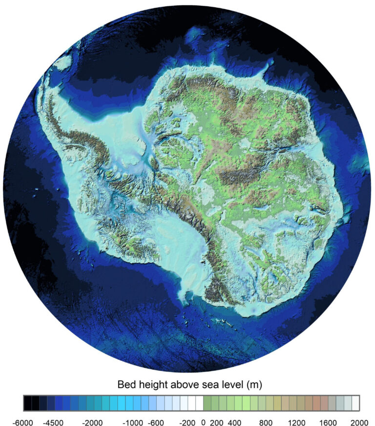
Using decades of data and more advanced computer software, scientists have now compiled the most detailed map of the land and shorelines hidden below Antarctica’s massive icecap.
The map to the right, reduced to post here, shows that bedrock terrain generally in hues of green to brown, with lower elevations comparable to the ocean in hues of blue. The actual shoreline is however impossible to determine, since without the pressure of the icecap on top, the continent would rise, while the ocean itself would also rise with the addition of all that water.
You can read the science paper here.. From the press release:
Known as Bedmap3, it incorporates more than six decades of survey data acquired by planes, satellites, ships and even dog-drawn sleds. … The map gives us a clear view of the white continent as if its 27 million cubic km of ice have been removed, revealing the hidden locations of the tallest mountains and the deepest canyons.
One notable revision to the map is the place understood to have the thickest overlying ice. Earlier surveys put this in the Astrolabe Basin, in Adélie Land. However, data reinterpretation reveals it is in an unnamed canyon at 76.052°S, 118.378°E in Wilkes Land. The ice here is 4,757 m thick, or more than 15 times the height of the Shard, the UK’s tallest skyscraper.
The paper describes at length the large uncertainties that exist in this data. As thorough as they tried to be, we must remember that Antarctica is very large with a very hostile environment. Much of it has never been visited by any humans. Getting an accurate picture of the thickness of the ice at all points is presently impossible. This is basically an excellent summary of our best guess.
On Christmas Eve 1968 three Americans became the first humans to visit another world. What they did to celebrate was unexpected and profound, and will be remembered throughout all human history. Genesis: the Story of Apollo 8, Robert Zimmerman's classic history of humanity's first journey to another world, tells that story, and it is now available as both an ebook and an audiobook, both with a foreword by Valerie Anders and a new introduction by Robert Zimmerman.
The print edition can be purchased at Amazon or from any other book seller. If you want an autographed copy the price is $60 for the hardback and $45 for the paperback, plus $8 shipping for each. Go here for purchasing details. The ebook is available everywhere for $5.99 (before discount) at amazon, or direct from my ebook publisher, ebookit. If you buy it from ebookit you don't support the big tech companies and the author gets a bigger cut much sooner.
The audiobook is also available at all these vendors, and is also free with a 30-day trial membership to Audible.
"Not simply about one mission, [Genesis] is also the history of America's quest for the moon... Zimmerman has done a masterful job of tying disparate events together into a solid account of one of America's greatest human triumphs."--San Antonio Express-News
I see Atlantis, a UFO base, and a HUMONGOUS pot farm.
I think ecologists just have this idea is that it is just ice and rock—but it has everything other landscapes have.
I talked to someone who tried to tell me that Antarctica had no volcanoes–forgetting Mt. Erebus—home to the stuck robot Dante.
This will make Greens made:
https://phys.org/news/2025-03-equal-wealth-bad-climate-expert.html
The idea that democracy is good for the climate is often ideologically driven, but this is based on a faulty premise.
The Greens won’t like that one bit…look at this op-ed nonsense:
https://phys.org/news/2025-03-opinion-environmental-laws-national-energy.html
Now if you’ll excuse me—I have to help Blair with his mini-saucer…
Hey, where are the Mountains of Madness?!
Tekeli li
It’s uncharted, man!
“the ocean itself would also rise with the addition of all that water”
3% of the worlds water is fresh… Antarctica contains 2 1/2% of that three. (most of the rest is in Greenland)
I lack the math skills to figure out how much higher the ocean level would be if it received 3% more? The diameter of the earth times pi minus the landmass? It would be interesting to know… The current global warming model says about 100 feet?
Lake Vostock is the largest freshwater lake and a half a mile deep… I wonder where it is on the map?
It’s interesting to know that that Antarctica has one of the driest climates in the world, the polar vortex discourages any weather systems from climbing over 10,000 feet to cross the continent. And yet the 100 foot tall short wave antenna erected in the 60s at the South Pole only has 40 feet still above the ice. That’s about 1 foot of ice per year.
The only place that far in land the water could originate is from polar stratospheric clouds… Solar aurora borealis oxidizing into water. The more active the sun, the more new water the earth receives causing ocean levels to rise about 5 to 8 inches per century. (besides gasses full of hydrogen that oxidize into water, there’s new nitrogen and carbon dioxide added to our atmosphere! Don’t tell the carbon capture people, it will drive them nuts.)
You can actually see it on that map. It’s the distinct long lake at the 3 o’clock position, halfway between the Transantarctic Mountains and the west coast of the continent.
As far as I’ve always known, Lake Baikal in Russia is the world’s largest freshwater lake, containing 20% of the world’s supply. Lake Vostok in Antarctica might be large, but I would not trust any claimed measurement of its content, considering it is buried under thousands of feet of ice.
Jeff Wright, “Now if you’ll excuse me—I have to help Blair with his mini-saucer…”
Nice one! Just the thing.
World Atlas: “With an average depth of 432 m (1,417 ft), it has an estimated volume of 5,400 km3 (1,300 cu mi) making it the 6th largest lake by volume.”
“Estimated.”
Good Food for thought.
We have been regaled for decades now how if the South Polar Ice Cap Melts we will all drown in rising sea levels.
This has always been based on the assumption, at least as far as I know, that the Antarctic Continent all about LAND under the ice cap.
That map tells a much revised perception. My perception (subject to large inaccuracy), is that 1/3 to 1/2 of the of the Antarctic Ice Sheet covers WATER. Well when Ice melts in water, the water level does not rise.
Other/Counter Thoughts anyone?
Andrew M Winter: An excellent point, one I had not considered. You point out again just one of the endless number of assumptions and uncertainties the global-warming crowd always wants to convince everyone do not exist.
The 25 largest lakes, side by side comparison:
https://www.visualcapitalist.com/worlds-25-largest-lakes/
I would put forth the proposition that Lake Michigan and Lake Huron, being connected by a 5-mile-wide strait, are in fact one large freshwater Lake, therefore the largest…
“Mackinac Straits; History & Importance”
The Restless Viking (Aug. 2024)
https://youtu.be/cRUS7W7nCNc
16:06