Strange wormlike tube features on slopes of Martian shield volcano
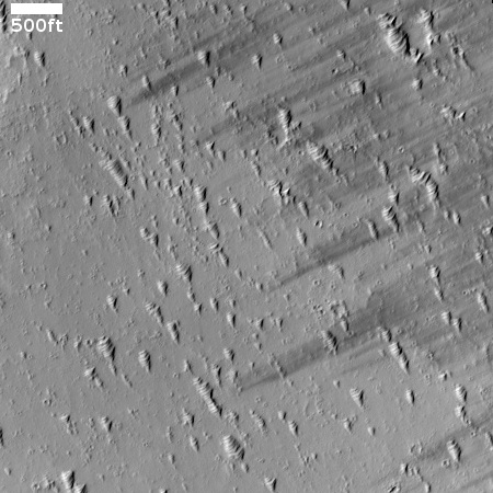
Cool image time! The picture to the right, cropped to post here, was taken on June 21, 2023 by the high resolution camera on Mars Reconnaissance Orbiter (MRO).
The scientists label the strange tubelike features that are scattered throughout this picture as “landforms,” which is correctly vague because their origin is utterly inexplicable. The ground here is on the eastern slope of a small 20-mile-wide very flat shield volcano located about 150 miles northwest of the giant volcano Ascraeus Mons. The dark wind streaks point down that grade to the east, away from the shield volcano’s peak about 1,000 feet away. (If you look at the full image this indistinct peak is at dead center, with a linear depression (the volcano’s vent) beginning there and heading to the northeast for about four miles.)
Why these many tubes are all oriented in a northwest-southwest direction, at right angles to the slope, is baffling, especially because they hold to that same orientation all across the shield volcano, no matter the downward direction of the slope.

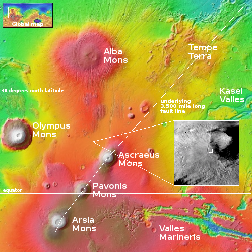
On the overview map to the right the small box in the inset marks the location of the picture above. The inset comes from a global mosaic made from MRO’s context camera images. I have increased its constrast to better bring out the shield volcano. The dark areas are not as dark as they appear here, and are caused by wind likely blowing the light dust away to reveal the darker flood lava below.
It is very clear from that context camera mosaic that lava flowed downward in all directions from that central vent. Yet somehow these tubelike features formed on top of the lava, or were there beforehand and not covered by it. Yet, if they form the top of buried topographical features why are they all the same height? One would think that the tubes lower down on the slopes would stick higher up above the lava. They do not.
The tubes themselves remind me of cave limestone features that I have seen sometimes on the sides of flowstone. The cave formations however always point uphill, on a vertical slope. The tubes here do not.
On Christmas Eve 1968 three Americans became the first humans to visit another world. What they did to celebrate was unexpected and profound, and will be remembered throughout all human history. Genesis: the Story of Apollo 8, Robert Zimmerman's classic history of humanity's first journey to another world, tells that story, and it is now available as both an ebook and an audiobook, both with a foreword by Valerie Anders and a new introduction by Robert Zimmerman.
The print edition can be purchased at Amazon or from any other book seller. If you want an autographed copy the price is $60 for the hardback and $45 for the paperback, plus $8 shipping for each. Go here for purchasing details. The ebook is available everywhere for $5.99 (before discount) at amazon, or direct from my ebook publisher, ebookit. If you buy it from ebookit you don't support the big tech companies and the author gets a bigger cut much sooner.
The audiobook is also available at all these vendors, and is also free with a 30-day trial membership to Audible.
"Not simply about one mission, [Genesis] is also the history of America's quest for the moon... Zimmerman has done a masterful job of tying disparate events together into a solid account of one of America's greatest human triumphs."--San Antonio Express-News
Cool image time! The picture to the right, cropped to post here, was taken on June 21, 2023 by the high resolution camera on Mars Reconnaissance Orbiter (MRO).
The scientists label the strange tubelike features that are scattered throughout this picture as “landforms,” which is correctly vague because their origin is utterly inexplicable. The ground here is on the eastern slope of a small 20-mile-wide very flat shield volcano located about 150 miles northwest of the giant volcano Ascraeus Mons. The dark wind streaks point down that grade to the east, away from the shield volcano’s peak about 1,000 feet away. (If you look at the full image this indistinct peak is at dead center, with a linear depression (the volcano’s vent) beginning there and heading to the northeast for about four miles.)
Why these many tubes are all oriented in a northwest-southwest direction, at right angles to the slope, is baffling, especially because they hold to that same orientation all across the shield volcano, no matter the downward direction of the slope.

On the overview map to the right the small box in the inset marks the location of the picture above. The inset comes from a global mosaic made from MRO’s context camera images. I have increased its constrast to better bring out the shield volcano. The dark areas are not as dark as they appear here, and are caused by wind likely blowing the light dust away to reveal the darker flood lava below.
It is very clear from that context camera mosaic that lava flowed downward in all directions from that central vent. Yet somehow these tubelike features formed on top of the lava, or were there beforehand and not covered by it. Yet, if they form the top of buried topographical features why are they all the same height? One would think that the tubes lower down on the slopes would stick higher up above the lava. They do not.
The tubes themselves remind me of cave limestone features that I have seen sometimes on the sides of flowstone. The cave formations however always point uphill, on a vertical slope. The tubes here do not.
On Christmas Eve 1968 three Americans became the first humans to visit another world. What they did to celebrate was unexpected and profound, and will be remembered throughout all human history. Genesis: the Story of Apollo 8, Robert Zimmerman's classic history of humanity's first journey to another world, tells that story, and it is now available as both an ebook and an audiobook, both with a foreword by Valerie Anders and a new introduction by Robert Zimmerman.
The print edition can be purchased at Amazon or from any other book seller. If you want an autographed copy the price is $60 for the hardback and $45 for the paperback, plus $8 shipping for each. Go here for purchasing details. The ebook is available everywhere for $5.99 (before discount) at amazon, or direct from my ebook publisher, ebookit. If you buy it from ebookit you don't support the big tech companies and the author gets a bigger cut much sooner.
The audiobook is also available at all these vendors, and is also free with a 30-day trial membership to Audible.
"Not simply about one mission, [Genesis] is also the history of America's quest for the moon... Zimmerman has done a masterful job of tying disparate events together into a solid account of one of America's greatest human triumphs."--San Antonio Express-News


Shai-hulud
I’ve search the picture extensively looking for any anomalies or clues for what we see visually. I got nothing.
Every circular mound, looks like a top, wide on the left side tapering down to a point on the right… But always perpendicular to the slope.
Viscous lava rolling downhill may make circular formations, but they would pile up like log jams, especially being larger on one end would tend to roll the heavy end downhill with the lighter end pointing up… Which is not the case.
At the bottom of the original picture and to the left there is a meteor impact that raises a circular formation into the air slightly and appears to be circular all the way around. I can fine no other that is exposed, broken free or pointing in the wrong direction. (some of the larger circular formations occur on each side of a meteor impact, adding more to the mystery) what would form ice cream cones?
At the bottom of the collapsed lava tube there seems to be overflow spill out that I can only see when you zoom out. Looking like a mud plane but barely detectable. The lighter coloration helps. Unfortunately, no correlation with the other formations, no answers here.
Max: Note that the tubes are not “always perpendicular to the slope”. The tubes to the north and south of the shield volcano’s peak are aligned with that slope, but in opposite directions.
Since you love to dig in and analyze the original image, I strongly urge you to also learn to use the Murray Lab’s global mosaic of MRO’s context camera images. Its profile tool allows you to measure the slope and elevation differences in each image, as well as the size of most features larger than 30 feet.
Finding the high resolution images on this global mosaic requires an overall knowledge of the global map, which is helped by turning on MRO’s MOLA elevation data, which adds the colors seen in all the overview maps I post. This can get you close. The lat-long data from each image’s main page can get you close enough then that you usually can spot the image itself and zoom in.
Max: The “overflow spill out” is frozen lava. The “lava tube” is a vent for the lava, flowing downhill to the north.
Thank you for the tools, perhaps we will hear more from others, especially the geologists who study such formations for their opinion about this alien world… That’s what fascinates me the most is the fact that this is a low gravity nearly airless cold “alien world” with unexpected surprises!
Thank you for posting these pictures.
As for the volcanic vent…
The frozen lava is spread thinley and evenly which is not usual. Lava tends to clump and be uneven, having ridges and spillways when things get jammed up as in other pictures you have posted. It’s definitely not fluid causing erosion channels evidenced by water? volcanoes. Perhaps a pyroclastic flow of dust? A separate mystery not related to the ridged mounds that circle navigate the volcano. Their uniform orientation reminds me of iron filings on a magnet.
Max: I’ve written about lava flows on Mars repeatedly, noting how compared to Earth it flows faster, with less viscosity, and more like debris-filled water. Think of the videos of the tsunami in Japan several years ago, especially the helicopter shots of the flood pushing debris across the landscape.
On Mars I’ve also posted numerous examples of places where the lava spread thinly and evenly. This is Mars, not Earth.