The mining potential on Mars
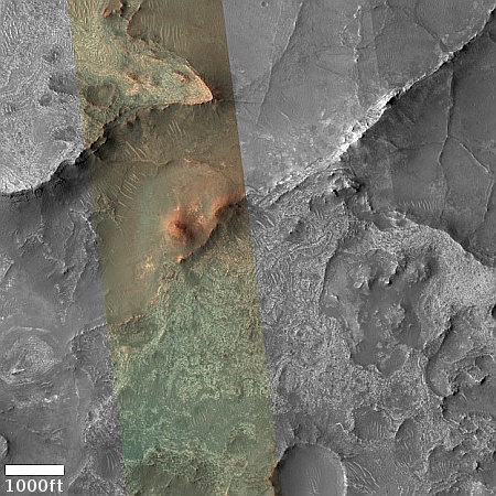
Cool image time! The picture to the right, cropped, reduced, and sharpened to post here, was taken on October 30, 2023 by the high resolution camera on Mars Reconnaissance Orbiter (MRO). Labeled simply as a “terrain sample,” it was probably taken not as part of any specific research project but to fill a gap in the schedule in order to properly maintain the camera’s temperature.
Nonetheless, the larger region where this photo is located is one of great interest to scientists as well as to future explorers. First note the colors. The wide variations between the bright orange of that peak (only a few tens of feet high) and the light orange and aqua-green of the bedrock to the north and south suggest a terrain with a lot of different materials within it.
The location is in the dry equatorial regions, so the swirls visible on the plateaus north and south of that small peak are not related to near surface ice. Instead, this is warped bedrock, with those swirls also suggesting material of a varied nature, exposed to the surface by erosion processes.

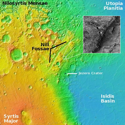
The white rectangle within the inset on the overview map to the right marks this location, near the southern terminus of the easternmost of the two major fissures that make-up Nils Fossae. If you look close at the inset you will see that the low terrain in the picture above is actually a drainage down into a large canyon flowing eastward into that larger fissure. While the smaller canyons were probably formed by some erosion process, either volcanic, water, or glacial in nature, the main fissures of Nils Fossae are likely grabens, cracks that formed when the ground stretched from pressure from below.
Nils Fossae is a region on Mars where orbital data has suggested the existence of lots of minerals. In fact, it is considered one of several areas on Mars with the highest concentrations of minerals, thus making it of great value to future colonists. These facts are why Perseverance landed here (as marked by the black dot in Jezero crater), because it is expected that when it travels west to leave Jezero it will enter this region. Scientists hope to document that mineral content, and therefore get a better understanding of the mining potential of Mars.
It is also why this photo was taken. The more this region can be mapped, the better chance future explorers will know where to go to get the resources they need to establish their permanent colonies.
On Christmas Eve 1968 three Americans became the first humans to visit another world. What they did to celebrate was unexpected and profound, and will be remembered throughout all human history. Genesis: the Story of Apollo 8, Robert Zimmerman's classic history of humanity's first journey to another world, tells that story, and it is now available as both an ebook and an audiobook, both with a foreword by Valerie Anders and a new introduction by Robert Zimmerman.
The print edition can be purchased at Amazon or from any other book seller. If you want an autographed copy the price is $60 for the hardback and $45 for the paperback, plus $8 shipping for each. Go here for purchasing details. The ebook is available everywhere for $5.99 (before discount) at amazon, or direct from my ebook publisher, ebookit. If you buy it from ebookit you don't support the big tech companies and the author gets a bigger cut much sooner.
The audiobook is also available at all these vendors, and is also free with a 30-day trial membership to Audible.
"Not simply about one mission, [Genesis] is also the history of America's quest for the moon... Zimmerman has done a masterful job of tying disparate events together into a solid account of one of America's greatest human triumphs."--San Antonio Express-News
Cool image time! The picture to the right, cropped, reduced, and sharpened to post here, was taken on October 30, 2023 by the high resolution camera on Mars Reconnaissance Orbiter (MRO). Labeled simply as a “terrain sample,” it was probably taken not as part of any specific research project but to fill a gap in the schedule in order to properly maintain the camera’s temperature.
Nonetheless, the larger region where this photo is located is one of great interest to scientists as well as to future explorers. First note the colors. The wide variations between the bright orange of that peak (only a few tens of feet high) and the light orange and aqua-green of the bedrock to the north and south suggest a terrain with a lot of different materials within it.
The location is in the dry equatorial regions, so the swirls visible on the plateaus north and south of that small peak are not related to near surface ice. Instead, this is warped bedrock, with those swirls also suggesting material of a varied nature, exposed to the surface by erosion processes.

The white rectangle within the inset on the overview map to the right marks this location, near the southern terminus of the easternmost of the two major fissures that make-up Nils Fossae. If you look close at the inset you will see that the low terrain in the picture above is actually a drainage down into a large canyon flowing eastward into that larger fissure. While the smaller canyons were probably formed by some erosion process, either volcanic, water, or glacial in nature, the main fissures of Nils Fossae are likely grabens, cracks that formed when the ground stretched from pressure from below.
Nils Fossae is a region on Mars where orbital data has suggested the existence of lots of minerals. In fact, it is considered one of several areas on Mars with the highest concentrations of minerals, thus making it of great value to future colonists. These facts are why Perseverance landed here (as marked by the black dot in Jezero crater), because it is expected that when it travels west to leave Jezero it will enter this region. Scientists hope to document that mineral content, and therefore get a better understanding of the mining potential of Mars.
It is also why this photo was taken. The more this region can be mapped, the better chance future explorers will know where to go to get the resources they need to establish their permanent colonies.
On Christmas Eve 1968 three Americans became the first humans to visit another world. What they did to celebrate was unexpected and profound, and will be remembered throughout all human history. Genesis: the Story of Apollo 8, Robert Zimmerman's classic history of humanity's first journey to another world, tells that story, and it is now available as both an ebook and an audiobook, both with a foreword by Valerie Anders and a new introduction by Robert Zimmerman.
The print edition can be purchased at Amazon or from any other book seller. If you want an autographed copy the price is $60 for the hardback and $45 for the paperback, plus $8 shipping for each. Go here for purchasing details. The ebook is available everywhere for $5.99 (before discount) at amazon, or direct from my ebook publisher, ebookit. If you buy it from ebookit you don't support the big tech companies and the author gets a bigger cut much sooner.
The audiobook is also available at all these vendors, and is also free with a 30-day trial membership to Audible.
"Not simply about one mission, [Genesis] is also the history of America's quest for the moon... Zimmerman has done a masterful job of tying disparate events together into a solid account of one of America's greatest human triumphs."--San Antonio Express-News


Speaking of mining…I wonder if this would be of use
https://m.youtube.com/watch?v=Sq0FsvkPMgo&embeds_referring_euri=https%3A%2F%2Fscitechdaily.com%2F&source_ve_path=Mjg2NjY&feature=emb_logo
https://scitechdaily.com/defying-gravity-scientists-solve-mystery-of-magnetic-hovering-beyond-classical-physics/