Volcanic vent on Mars

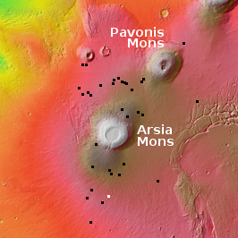
To understand today’s cool image we really should start from a distance and zoom in. The overview map to the right focuses in on the two southernmost giant volcanoes in the string of three that sit to the east of Mars’ biggest volcano, Olympus Mons, and to the west of the planet’s biggest canyon, Valles Marineris.
The black dots mark the locations of the many high resolution photos taken by Mars Reconnaissance Orbiter that I have featured previously on Behind the Black. Many are isolated openings with no related geological features. Others appear to be skylights into a more extensive lava tube, hinted at by either a continuing surface depression or a series of similar skylights.
The white dot marks the location of today’s cool image, about 350 miles south of Arsia Mons’ caldera.

Click here, here, and here for original images.
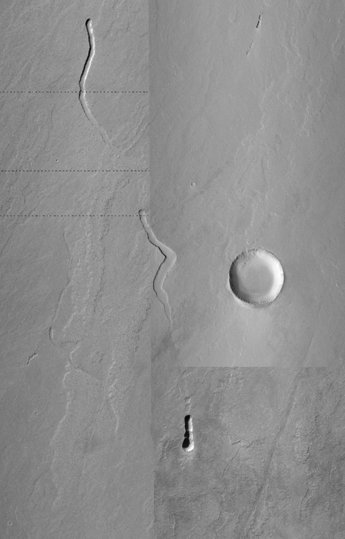
The first photo to the right is a mosaic made from three MRO context camera photos. The downhill grade flows to the south. This entire smooth surface is probably a lava flood plain, material that was discharged from Arsia Mons more than a billion years ago when the volcano was active. That the volcano was able to deposit this much lava 350 some odd miles from its caldera illustrates both how powerful the volcano was as well how different lava flows are in Mars’s weaker gravity. They can go farther, and more quickly before they freeze.
Winding through this volcanic plain are three meandering depressions, with the top two each beginning with a deeper sinkhole, as if some liquid, likely lava, had poured out of that deeper opening and as it flowed southward it carved the meandering hollows before disappearing underground again only to pop up later out from the next deep sink.
When the flow reached the southernmost and deepest pit it seems to have no longer flowed directly south in a line. Instead, if you look close you can see what looks like an flow spreading outward from that pit in a southerly direction, but in a wide dispersed manner.
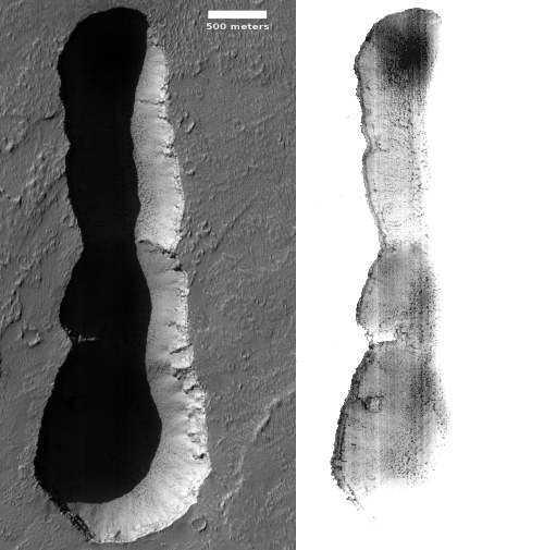
The last picture to the right, rotated, cropped, and reduced to post here, was taken on August 31, 2021 by MRO’s high resolution camera of that southernmost pit. The second image to the right is that same pit, brightened enough so that the details within the shadows can be seen. Based on this imagery, it appears that there are no openings or skylights into voids below, such as a lava tube.
Thus, the meandering depression in the mosaic indicate the existence of an underground lava tube, but the available information suggests it is mostly filled.
On Christmas Eve 1968 three Americans became the first humans to visit another world. What they did to celebrate was unexpected and profound, and will be remembered throughout all human history. Genesis: the Story of Apollo 8, Robert Zimmerman's classic history of humanity's first journey to another world, tells that story, and it is now available as both an ebook and an audiobook, both with a foreword by Valerie Anders and a new introduction by Robert Zimmerman.
The print edition can be purchased at Amazon or from any other book seller. If you want an autographed copy the price is $60 for the hardback and $45 for the paperback, plus $8 shipping for each. Go here for purchasing details. The ebook is available everywhere for $5.99 (before discount) at amazon, or direct from my ebook publisher, ebookit. If you buy it from ebookit you don't support the big tech companies and the author gets a bigger cut much sooner.
The audiobook is also available at all these vendors, and is also free with a 30-day trial membership to Audible.
"Not simply about one mission, [Genesis] is also the history of America's quest for the moon... Zimmerman has done a masterful job of tying disparate events together into a solid account of one of America's greatest human triumphs."--San Antonio Express-News

To understand today’s cool image we really should start from a distance and zoom in. The overview map to the right focuses in on the two southernmost giant volcanoes in the string of three that sit to the east of Mars’ biggest volcano, Olympus Mons, and to the west of the planet’s biggest canyon, Valles Marineris.
The black dots mark the locations of the many high resolution photos taken by Mars Reconnaissance Orbiter that I have featured previously on Behind the Black. Many are isolated openings with no related geological features. Others appear to be skylights into a more extensive lava tube, hinted at by either a continuing surface depression or a series of similar skylights.
The white dot marks the location of today’s cool image, about 350 miles south of Arsia Mons’ caldera.

Click here, here, and here for original images.
The first photo to the right is a mosaic made from three MRO context camera photos. The downhill grade flows to the south. This entire smooth surface is probably a lava flood plain, material that was discharged from Arsia Mons more than a billion years ago when the volcano was active. That the volcano was able to deposit this much lava 350 some odd miles from its caldera illustrates both how powerful the volcano was as well how different lava flows are in Mars’s weaker gravity. They can go farther, and more quickly before they freeze.
Winding through this volcanic plain are three meandering depressions, with the top two each beginning with a deeper sinkhole, as if some liquid, likely lava, had poured out of that deeper opening and as it flowed southward it carved the meandering hollows before disappearing underground again only to pop up later out from the next deep sink.
When the flow reached the southernmost and deepest pit it seems to have no longer flowed directly south in a line. Instead, if you look close you can see what looks like an flow spreading outward from that pit in a southerly direction, but in a wide dispersed manner.
The last picture to the right, rotated, cropped, and reduced to post here, was taken on August 31, 2021 by MRO’s high resolution camera of that southernmost pit. The second image to the right is that same pit, brightened enough so that the details within the shadows can be seen. Based on this imagery, it appears that there are no openings or skylights into voids below, such as a lava tube.
Thus, the meandering depression in the mosaic indicate the existence of an underground lava tube, but the available information suggests it is mostly filled.
On Christmas Eve 1968 three Americans became the first humans to visit another world. What they did to celebrate was unexpected and profound, and will be remembered throughout all human history. Genesis: the Story of Apollo 8, Robert Zimmerman's classic history of humanity's first journey to another world, tells that story, and it is now available as both an ebook and an audiobook, both with a foreword by Valerie Anders and a new introduction by Robert Zimmerman.
The print edition can be purchased at Amazon or from any other book seller. If you want an autographed copy the price is $60 for the hardback and $45 for the paperback, plus $8 shipping for each. Go here for purchasing details. The ebook is available everywhere for $5.99 (before discount) at amazon, or direct from my ebook publisher, ebookit. If you buy it from ebookit you don't support the big tech companies and the author gets a bigger cut much sooner.
The audiobook is also available at all these vendors, and is also free with a 30-day trial membership to Audible.
"Not simply about one mission, [Genesis] is also the history of America's quest for the moon... Zimmerman has done a masterful job of tying disparate events together into a solid account of one of America's greatest human triumphs."--San Antonio Express-News


The different behavior in flow of Martian lava may also result in geometry of lava tubes that differ from earth ‘tunnels’. For example, the tubes may have width to height ratios that are dissimilar from terrestrial lava tubes. That may have implications for use of lava tubes as shelter during future exploration.
Greg the Geologist:
Curious for your take on the ” geometry of lava tubes ” vis-a-vis terrestrial ones. I have seen, and walked in, lava tubes in Hawai’i and the Northwest US. I have seen subsided volcanic flows in Hawai’i, and understand that lava is full of gas, and when cooling, releases that gas, so the flow subsides a bit.
It seems that with 0.3g and (let us assume) a comparable amount of gas in solution, the tubes would be much higher than Earthside ones, but maybe the same width?