
Why this place in Valles Marineris is NOT a good place to establish trails and inns


Click for original image.
In my cool image yesterday I highlighted a location along the north rim of the gigantic Valles Marineris canyon on Mars that appeared a great place to establish a hiking trail. The trail would take hikers down from the rim to the floor of the canyon, a distance of more than 20 miles with an elevation loss of more than 31,000 feet, more than the height of Mount Everest. The image to the right shows the top of that trail, at the rim. The white dot on the overview map above shows its location in Valles Marineris.
Because of the trail’s length I also suggested that future colonists would likely set up inns along the way, so that hikers would have places to stay as they worked their way downhill day-by-day.
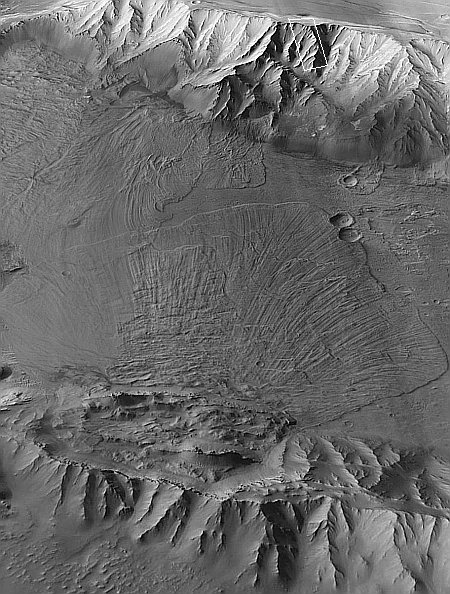
There is however one major reason not to build at this particular location, and it involves the most significant geological detail I noticed in the picture to the right. Note the arrows in both this image as well as the inset above. In the picture they mark a sudden drop paralleling the rim. In the inset they also show a series of parallel cracks further north.
The cliff and the cracks suggest that the entire cliff of this part of the north rim has subsided, and is in fact beginning to separate from the plateau, and will soon (in geological terms) collapse into a spectacular avalanche. If you look at the cliff face in the inset you can see two extended outflow piles that apparently came from smaller earlier such collapses.
Could this entire cliff face, the size of Mount Everest, actually separate and crash into the canyon? If you have doubts, then take a look at the image below.
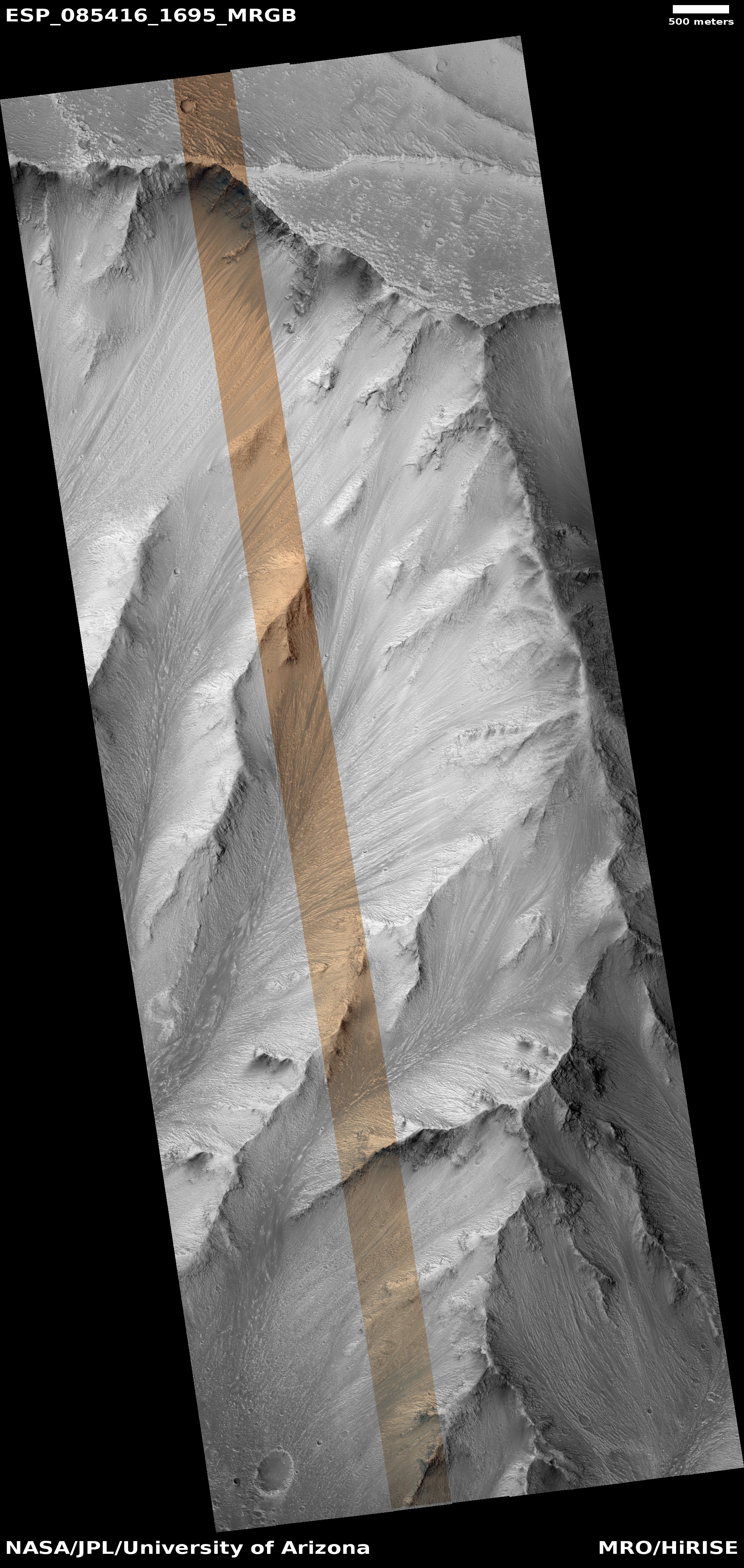
The picture to the right is taken from a mosaic of Mars Reconnaissance Orbiter’s (MRO) context camera photos. This camera takes wider shots at lower resolution, but it has been used to provide a global and very detailed map of almost the entire planet.
The rectangle in the picture marks the area covered by yesterday’s cool image. The rectangle on the overview map above indicates the area covered by this mosaic. It includes not only the north rim and the canyon floor, but also the chain of mountains to the south that runs through the canyon.
Look at that southern mountain chain as well as the floor of the canyon. It appears that a very large section of that chain, fifteen miles across and seven miles wide, broke free and fell downward to the north. As it did so it threw out a vast wave of looser debris the flowed north more than 27 miles, covering almost the entire canyon floor.
If such a gigantic avalanche can occur here, it certainly can occur on the higher north rim.
The size of these collapses illustrate the alien nature of Mars. Its lower gravity, about 39% that of Earth, means that its bedrock is not as dense or as compacted. Larger sections can break off, and when they do, they can flow quickly almost like water. These collapses (as well as the potential one on the north rim) also give us a hint as to how a canyon as vast and as deep as Valles Marineris formed.
Does this geological data say there is no place safe to build tourist inns and trails on Mars. Of course not. Not only do these events happen on geological time scales, Valles Marineris is 1,500 miles long. There will be plenty of other places along its rim where the ground is more solid and tourism can flourish quite safely.
It can even occur at this location, though I would strongly advice a network of seismometers be set up to monitor any movements in the ground.

On Christmas Eve 1968 three Americans became the first humans to visit another world. What they did to celebrate was unexpected and profound, and will be remembered throughout all human history. Genesis: the Story of Apollo 8, Robert Zimmerman's classic history of humanity's first journey to another world, tells that story, and it is now available as both an ebook and an audiobook, both with a foreword by Valerie Anders and a new introduction by Robert Zimmerman.
The print edition can be purchased at Amazon or from any other book seller. If you want an autographed copy the price is $60 for the hardback and $45 for the paperback, plus $8 shipping for each. Go here for purchasing details. The ebook is available everywhere for $5.99 (before discount) at amazon, or direct from my ebook publisher, ebookit. If you buy it from ebookit you don't support the big tech companies and the author gets a bigger cut much sooner.
The audiobook is also available at all these vendors, and is also free with a 30-day trial membership to Audible.
"Not simply about one mission, [Genesis] is also the history of America's quest for the moon... Zimmerman has done a masterful job of tying disparate events together into a solid account of one of America's greatest human triumphs."--San Antonio Express-News
Click for original image.
In my cool image yesterday I highlighted a location along the north rim of the gigantic Valles Marineris canyon on Mars that appeared a great place to establish a hiking trail. The trail would take hikers down from the rim to the floor of the canyon, a distance of more than 20 miles with an elevation loss of more than 31,000 feet, more than the height of Mount Everest. The image to the right shows the top of that trail, at the rim. The white dot on the overview map above shows its location in Valles Marineris.
Because of the trail’s length I also suggested that future colonists would likely set up inns along the way, so that hikers would have places to stay as they worked their way downhill day-by-day.
There is however one major reason not to build at this particular location, and it involves the most significant geological detail I noticed in the picture to the right. Note the arrows in both this image as well as the inset above. In the picture they mark a sudden drop paralleling the rim. In the inset they also show a series of parallel cracks further north.
The cliff and the cracks suggest that the entire cliff of this part of the north rim has subsided, and is in fact beginning to separate from the plateau, and will soon (in geological terms) collapse into a spectacular avalanche. If you look at the cliff face in the inset you can see two extended outflow piles that apparently came from smaller earlier such collapses.
Could this entire cliff face, the size of Mount Everest, actually separate and crash into the canyon? If you have doubts, then take a look at the image below.
The picture to the right is taken from a mosaic of Mars Reconnaissance Orbiter’s (MRO) context camera photos. This camera takes wider shots at lower resolution, but it has been used to provide a global and very detailed map of almost the entire planet.
The rectangle in the picture marks the area covered by yesterday’s cool image. The rectangle on the overview map above indicates the area covered by this mosaic. It includes not only the north rim and the canyon floor, but also the chain of mountains to the south that runs through the canyon.
Look at that southern mountain chain as well as the floor of the canyon. It appears that a very large section of that chain, fifteen miles across and seven miles wide, broke free and fell downward to the north. As it did so it threw out a vast wave of looser debris the flowed north more than 27 miles, covering almost the entire canyon floor.
If such a gigantic avalanche can occur here, it certainly can occur on the higher north rim.
The size of these collapses illustrate the alien nature of Mars. Its lower gravity, about 39% that of Earth, means that its bedrock is not as dense or as compacted. Larger sections can break off, and when they do, they can flow quickly almost like water. These collapses (as well as the potential one on the north rim) also give us a hint as to how a canyon as vast and as deep as Valles Marineris formed.
Does this geological data say there is no place safe to build tourist inns and trails on Mars. Of course not. Not only do these events happen on geological time scales, Valles Marineris is 1,500 miles long. There will be plenty of other places along its rim where the ground is more solid and tourism can flourish quite safely.
It can even occur at this location, though I would strongly advice a network of seismometers be set up to monitor any movements in the ground.
On Christmas Eve 1968 three Americans became the first humans to visit another world. What they did to celebrate was unexpected and profound, and will be remembered throughout all human history. Genesis: the Story of Apollo 8, Robert Zimmerman's classic history of humanity's first journey to another world, tells that story, and it is now available as both an ebook and an audiobook, both with a foreword by Valerie Anders and a new introduction by Robert Zimmerman.
The print edition can be purchased at Amazon or from any other book seller. If you want an autographed copy the price is $60 for the hardback and $45 for the paperback, plus $8 shipping for each. Go here for purchasing details. The ebook is available everywhere for $5.99 (before discount) at amazon, or direct from my ebook publisher, ebookit. If you buy it from ebookit you don't support the big tech companies and the author gets a bigger cut much sooner.
The audiobook is also available at all these vendors, and is also free with a 30-day trial membership to Audible.
"Not simply about one mission, [Genesis] is also the history of America's quest for the moon... Zimmerman has done a masterful job of tying disparate events together into a solid account of one of America's greatest human triumphs."--San Antonio Express-News
It reminds me of the “Knife Edge” at the very north end of the Appalachian Trail.
Tread carefully.
Think I’ll wait from the tram!
Concur that this looks like a series of debris flows, of impressive size. An analysis of craters might suggest the age of these collapse features. Note we do have similar features right here, even in California, though the distances are not as long due to earth’s higher gravity. For example, a long run-out slide occurred during the Pleistocene along the north slopes of the San Bernardino Mountains. Check out aerial or satellite images of the Blackhawk Slide. There are also submarine slides of comparable extent to those you show on Mars. I can only imagine the resulting tsunami…