
NASA inspector general: Air leak in Zvezda module on ISS increased significantly in 2024
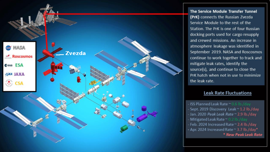
Figure 3 from IG report, annotated by me to show Zvezda location.
According to a new report [pdf] from NASA’s inspector general, the air leaks in the Russian Zvezda module on ISS increased significantly in 2024, reaching “the highest level of risk in its risk management system,” and more than six times the normal planned leak rate for the station (see the box in the lower corner of the figure above).
[I]n February 2024 NASA identified an increase in the leak rate, and the Agency and Roscosmos continue to assess the risk that the increase poses to the module’s structure. In May and June 2024, ISS Program and Roscosmos officials met to discuss heightened concerns with the increased leak rate. The ISS Program subsequently elevated the Service Module [Zvezda] Transfer Tunnel leak risk to the highest level of risk in its risk management system. According to NASA, Roscosmos is confident they will be able to monitor and close the hatch to the Service Module prior to the leak rate reaching an untenable level. However, NASA and Roscosmos have not reached an agreement on the point at which the leak rate is untenable.
To mitigate potential impacts from the air leaks, NASA and Roscosmos continuously monitor leak rates and close the hatch to the Service Module when access is not required, sealing the module to minimize air loss while isolating the leak. While it is possible for the ISS to function if the hatch is closed permanently, it could impact cargo delivery because there would be one less cargo delivery port. Closing the hatch permanently would also necessitate additional propellent to maintain the Station’s altitude and attitude. Although the root cause of the leak remains unknown, both agencies have narrowed their focus to internal and external welds. As of June 2024, there was no indication of other leaks on the Station.
The transfer tunnel is the section of Zvezda that connects it to ISS. Though the report is very careful not to say anything specific about the cause of the leak, the evidence strongly suggests it is caused by stress fractures in the module’s hull, fractures that indicate a serious and dangerous long term issue. The tunnel however cannot be replaced without replacing Zvezda, and Zvezda cannot be replaced without detaching the entire Russian section from ISS, something that is likely very difficult and maybe impossible to do. And even if it could be replaced, Russia does not have the capability or the money right now to build a replacement.
The report also noted that keeping the station operating through 2030 faces other challenges, including the lack of redundancy for getting cargo and crew to ISS, the increasing difficulty of obtaining spare parts for the station, the long term damage from micrometeoroids and orbital debris, and finally, the unknown commitment of Russia, which at this point has not yet decided whether it will remain a partner after 2028.
All these issues underline the need for the four American private commercial space stations to reach orbit and get operational before 2028.


