Why we really celebrate the Fourth of July
I posted this essay last year on July 4th. Time to repost it. I must add that my hopes for the November 2022 election were not realized, and we are now on the brink of losing our free country, forever, a fact that horrifies me beyond words.
—————-
Why we really celebrate the Fourth of July
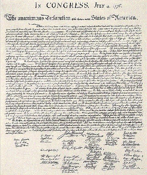
If you really want to know why the Fourth of July has been the quintessential American holiday since the founding our this country, you need only return to the words of the document that became public to the world on that day.
Below the fold is the full text of the Declaration. Read it. It isn’t hard to understand, even if the style comes from the late 1700s. Its point however is clear. Governments that abuse the rights of the citizenry don’t deserve to be in power. The most important quote of course is right near the beginning:
We hold these truths to be self-evident, that all men are created equal, that they are endowed by their Creator with certain unalienable Rights, that among these are Life, Liberty and the pursuit of Happiness.
That to secure these rights, Governments are instituted among Men, deriving their just powers from the consent of the governed — that whenever any Form of Government becomes destructive of these ends, it is the Right of the People to alter or to abolish it, and to institute new Government, laying its foundation on such principles and organizing its powers in such form, as to them shall seem most likely to effect their Safety and Happiness.
Prudence, indeed, will dictate that Governments long established should not be changed for light and transient causes; and accordingly all experience hath shewn, that mankind are more disposed to suffer, while evils are sufferable, than to right themselves by abolishing the forms to which they are accustomed. But when a long train of abuses and usurpations, pursuing invariably the same Object evinces a design to reduce them under absolute Despotism, it is their right, it is their duty, to throw off such Government, and to provide new Guards for their future security. [emphasis mine]
What a radical concept — a nation founded on the principle of allowing its citizens to pursue happiness.
Right now, however, we have a federal government in America that more fits the description of King George III’s Great Britain in 1776 in the Declaration. The corrupt elitist uni-Party of federal elected officials and the federal bureaucracy in Washington has for too long run roughshod over the general population. If you take the time to read the full text of the Declaration, you will be astonished at the remarkable conceptual similarity between the abuses that Jefferson describes coming from Great Britain and the many abuses of power that are now legion and common by the uni-Party in Washington.
When November comes the American public will likely have its last chance to overthrow the political wing of the uni-Party, led by the Democratic Party. The Republicans are no saints, but at least that party contains within it many decent politicians who honor the Constitution, the rule of law, and the Bill of Rights. Many are right now campaigning on those ideals. Based on the past six years, we now know that no one in the Democratic Party honors those values. What they honor is blacklisting, racism, segregation, anti-American hate, and above all power. If they are not removed from office, they will ramp up that power, in league with quislings like Romney and Cornyn in the Republican Party, to further corrupt our Constitutional government.
These people do not like losing power. The longer they hold it, the more they will work to undermine the election system to make sure they do not lose. The corruption and election fraud in 2020 election was merely a dress rehearsal of what these goons will do if they have the chance next year.
In fact, November 2022 might very well be the last election that has any chance of producing legitimate results. Americans had better not waste this last chance.
» Read more