Musk: Starship/Superheavy launchpad essentially undamaged after launch
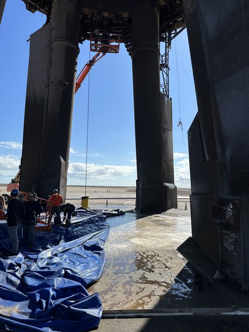
In a tweet posted only a short time ago, Elon Musk announced that the redesigned and rebuilt Boca Chica launchpad experienced little or no damage during the launch of Superheavy/Starship on November 18, 2023.
Just inspected the Starship launch pad and it is in great condition!
No refurbishment needed to the water-cooled steel plate for next launch.
Congrats to @Spacex team & contractors for engineering & building such a robust system so rapidly!
Musk included the picture to the right in the tweet, showing the essentially undamaged launchpad pad. A close looks suggests there was some damage to the rear pillar near the top, but overall it appears the next launch could occur here very quickly.
Musk of course is wrong about who he credits for redesigning and rebuilding this launchpad. The real credit must go to the FAA bureaucrats who led the investigation and must have clearly guided those SpaceX engineers and contractors. To expect private citizens to think for themselves and come up with such difficult engineering without supervision from government paper-pushers in Washington is unreasonable and unfair. Maybe the Biden Justice Department should consider another lawsuit against Musk, this time for spreading more disinformation!
Moreover, who cares that the launchpad deluge system worked exactly as planned? We must allow Fish & Wildlife to spend several months now to investigate this launch — as well as write a long report of many words — to make sure that deluge of water did not harm any of the wildlife that lives on this barrier island, which has a water table of essentially zero and is flooded regularly and repeatedly by storms over time.
Anyone who disagrees is clearly a bigoted racist who wants to harm little children!

