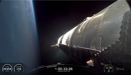
Starship in orbit before losing its attitude control
SpaceX today was able to successfully launch Starship and Superheavy on its ninth test flight, lifting off from SpaceX’s Starbase spaceport at Boca Chica.
The Superheavy booster completed its second flight, with one of its Raptor engines actually flying for the third time. Rather than recapture it with the launchpad chopsticks, engineers instead decided to push its re-entry capabilities to their limit. The booster operated successfully until it was to make its landing burn over the Gulf of Mexico, but when the engines ignited all telemetry was lost. Apparently that hard re-entry path was finally too much for the booster.
Starship reached orbit and functioned successfully for the first twenty minutes or so. When engineers attempted a test deployment of some dummy Starlink satellites, the payload door would not open properly. The engineers then closed the door and canceled the deployment.
Subsequently leaks inside the spacecraft with its attitude thrusters caused the attitude system to shut down and Starship started to spin in orbit. At that point the engineers cancelled the Raptor engine relight burn. The spacecraft then descended over the Indian Ocean as planned, but in an uncontrolled manner. Mission control then vented its fuel to reduce its weight and explosive condition. It essentially broke up over the ocean, with data was gathered on the thermal system until all telemetry was lost.
Though overall this was a much more successful flight than the previous two, both of which failed just before or as Starship reached orbit, the test flight once again was unable to do any of its objectives in orbit. It did no deployment test, no orbital Raptor engine burn test, and no the re-entry tests of Starship’s thermal protection system. Obviously the engineers gathered a great deal of data during the flight, but far less than hoped for.
SpaceX has a lot of Superheavy and Starship prototypes sitting in the wings. I expect it will attempt its next flight test, the tenth, relatively quickly, by July at the very latest. I also do not expect the FAA to stand in the way. It will once again accept SpaceX’s investigative conclusions instantly and issue a launch license, when SpaceX stays it is ready to launch.
As Starship reached orbit as planned, I am counting this as a successfully launch. The leaders in the 2025 launch race:
64 SpaceX
30 China
6 Rocket Lab
6 Russia
SpaceX now leads the rest of the world in successful launches, 64 to 49.