Lunar Reconnaissance Orbiter snaps picture of Blue Ghost on the Moon

Blue Ghost on the Moon
Click for full image. For original of inset go here.

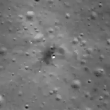
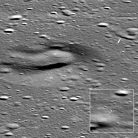
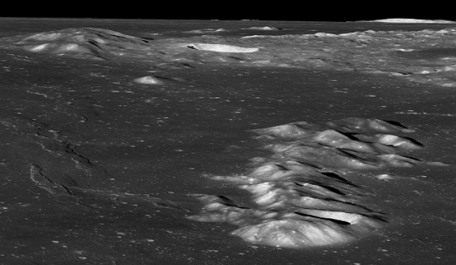
Shortly after Firefly’s Blue Ghost lunar lander touched down within Mare Crisium on the Moon, the science team for Lunar Reconnaissance Orbiter (LRO) used it to capture a picture of lander on the surface of the Moon.

That image is to the right, reduced to post here. The inset was expanded and sharpened to bring out the details, with the arrow showing Blue Ghost, that tiny dot in the center with a shadow to the right.

The Firefly Blue Ghost lunar lander set down on 2nd March 2025. The landing site (arrow) is about 4000 meters from the center of Mons Latreille, a large volcanic cone [seen to the left].

…LRO was 175 kilometers east (19.294°N, 67.956°E) of the landing site when the NACs acquired this dramatic view of the landing site on 02 March 2025 at 17:49 UTC.

Blue Ghost landed shortly after lunar sunrise, and is designed to operate for one full lunar day (fourteen Earth days). Whether it can survive the 14-day-long lunar night won’t be known until the next sunrise.

A new geologic map of one of the Moon’s largest impact basins

Orientale Basin on the Moon
Click for original image.

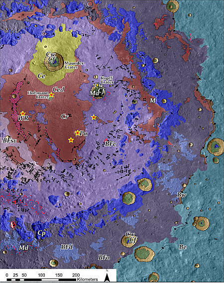
Using data from Lunar Reconnaissance Orbiter (LRO), scientists have now produced a high resolution geological map of Orientale Basin, one of the largest impact basins on the Moon — at about 600 miles across — and located just on the edge of the Moon’s visible near side.

That map is to the right, reduced and sharpened to post here. You can read the paper here [pdf]. From the press release:

Planetary Science Institute Research Scientist Kirby Runyon is a lead author on a paper published in the Planetary Science Journal containing a new high-resolution geologic map of Orientale basin that attempts to identify original basin impact melt. The hope is that future researchers use this map to target sample return missions and pin down impact dates for this and other impact basins.

“We chose to map Oriental basin because it’s simultaneously old and young,” Runyon said. “We think it’s about 3.8 billion years old, which is young enough to still have its impact melt freshly exposed at the surface, yet old enough to have accumulated large impact craters on top of it as well, complicating the picture. We chose to map Orientale to test melt-identification strategies for older, more degraded impact basins whose ages we’d like to know.”

The map’s prime purpose is to pin down locations where material from the actual impact exist and can be returned to Earth for precise dating, thus helping to create a more accurate timeline of the Moon’s formation as well as the entire solar system’s accretion rate.

Young lava on the Moon?

Young lava on the Moon?
Click for original image.

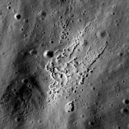
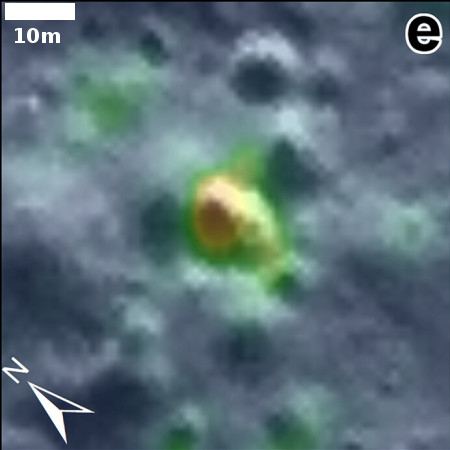
Cool image time! The photo to the right, cropped and reduced to post here, was taken on November 27, 2023 by Lunar Reconnaissance Orbiter (LRO) and was today featured by the science team. From their caption:

One of the early findings from the LRO mission was the discovery of volcanic features known as Irregular Mare Patches (IMPs) scattered across the nearside. These landforms are generally considered volcanic. However, their ages are hotly debated. They may be as young as 50 million years or as old as 3.5 billion years. The Aristarchus IMP (25.045°N, 313.233°E) is one of the smallest and most enigmatic IMP. The fact that this IMP is found within the Aristarchus crater ejecta suggests it formed after the crater, which is dated at 200 million years.

Alternatively, this IMP may have formed as part of ejecta emplacement from the Aristarchus crater forming impact. However, no other crater ejecta on the Moon exhibits a similar landform.

Astronomers for decades before and since Sputnick have reported what appears to be some activity in the Aristachus region, though none of those reports have ever been confirmed. In LRO’s long mission orbiting the Moon it has not yet detected any obvious changes there, suggesting that there is little or no present activity. These patches however appear to indicate activity in the relatively recent past.

The patches however also indicate activity that seems alien. Why would the lava form in this manner, as rough patch of knobs, sometimes aligned, sometimes not?

Water on the Moon? New data analysis from two different lunar orbiters say yes

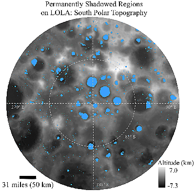
Two papers in the past month using data from two different lunar orbiters have claimed the presence of water on Moon, based on the detection of evidence of hydrogen on the surface.

First, on September 16, 2024 scientists published a paper [pdf] that analyzed data collected in 2009 by India’s Chandrayaan-1 lunar orbiter, and concluded, as stated enthusiastically in the press release:

Map of permanently shadowed regions at the Moon's south pole
From the second paper, a map of permanently shadowed
regions at the Moon’s south pole. Click for original.

“Future astronauts may be able to find water even near the equator by exploiting these water-rich areas. Previously, it was thought that only the polar region, and in particular, the deeply shadowed craters at the poles were where water could be found in abundance,” said Roger Clark, Senior Scientist at the Planetary Science Institute and lead author of “The Global Distribution of Water and Hydroxyl on the Moon as Seen by the Moon Mineralogy Mapper (M3)” that appears in the Planetary Science Journal. “Knowing where water is located not only helps to understand lunar geologic history, but also where astronauts may find water in the future.”

Then today NASA announced the publication of a new paper [pdf] that looked at the data collected over the last decade by Lunar Reconnaissance Orbiter (LRO), and have concluded that “hydrogen-bearing volatiles are observed to be concentrated, likely in the form of water ice, within most of the Moon’s permanently shadowed regions (PSRs), poleward of 77°.” The press release, which included the map to the right of permanently shadowed areas at the Moon’s south pole, was more enthusiastic:
» Read more

Scientists locate lunar impact crater produced by LCROSS in 2009

Figure 2 of research paper
Taken from figure 2 of the paper. Click for
original image.

Using orbital radar and opitcal images scientists finally believe they have identified the small crater on the Moon produced when — as part of the 2009 LCROSS mission — an abandoned rocket stage crashed in a permanently shadowed section of Cabeus crater near the lunar south pole.

LCROSS was designed to study the ejecta thrown up by that impact, and found “a significant amount of water, estimated at 5.6 ± 2.9% by mass, as well as minor amounts of other volatile species.” Because the impact was in that permanently shadowed region, however, locating the new crater required new instrumentation.

Using a radar instrument on Lunar Reconnaissance Orbiter (LRO) as well as the Shadowcam instrument on South Korea’s Danuri orbiter — designed to take optical images in very low light — the scientists pinpointed that impact crater, as shown in the image to the right, overlaying both the radar and optical images. The crater is estimated to be about 22 meters across, about 25% smaller than predicted. From this the scientists conclude that the water in the ejecta plume came from close to the surface, and thus could only have been placed there in the past billion years. Before that, the location was not in shadow, and volatiles like water could not have survived if they were near the surface.

From this data the scientists believe the water was likely placed there by the “recent delivery by comets or the solar wind, rather than as a paleo-reservoir from an early volcanic atmosphere.” If so, the amount of material can be reasonably predicted, and is likely less than hoped for because it only exists in the top two meters.

A pit on the Moon reveals some really bad journalism

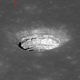
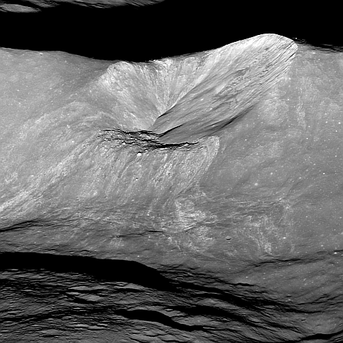
Mare Tranquilitatis Pit

At the start of this week three different major news organizations posted articles about a so-called “discovery” of a cave on the Moon that could sustain a human colony.

What all three articles [now updated with a fourth] demonstrated however was how little research was done by the journalists who wrote the articles, as well as the lack of any editorial supervision to make sure the news organization publishing the stories didn’t look stupid.

Here are the articles in question:

The original paper that these stories are based on can be read here. It didn’t take me more than five seconds to immediately recognize that the pit in question, dubbed the Mare Tranquillitatis pit, has been known about for years. I in fact wrote about it as long ago as 2011, when researchers used Lunar Reconnaissance Orbiter (LRO) to take oblique images of it. One such image is to the right, cropped and enhanced to post here.

The new research has simply used the radar instrument on LRO to take oblique radar data to see if there are any cave passages at its base, and found that there could be voids leading off from the pit as much as “tens of meters” long, or about 100 feet or so.

This is good research, but the finding is hardly significant. Numerous other studies have suggested the same results, all tantalizing but entirely unconfirmed until we can send some probe (manned or manned) into these pits. In addition, hundreds of similar lunar pits have been documented for more than a decade.

Yet the first two articles above treated this cave as God’s gift to humanity, as if it was the first such pit found on the Moon that could hold a human base, while the third provided so little information about the background of this work that the article was essentially worthless.

I write this as a warning to my readers. Mainstream news sources no longer do the proper due diligence that should be expected from writers and editors. If you want good information, you need to go to sources that specialize in the subject (such this website), and you must go to more than one in order to understand the subject entirely.

Lunar Reconnaissance Orbiter snaps picture of Chang’e-6 on far side of the Moon

Chang'e-6's landing site
Click for original image of Chang’e-6 on the Moon

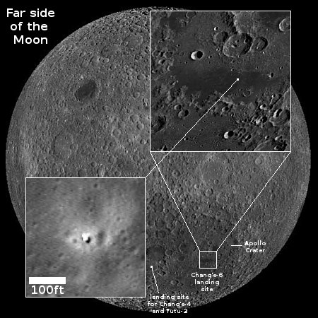
The science team running Lunar Reconnaissance Orbiter (LRO) have now released an image of China’s Chang’e-6 lander on far side of the Moon, taken on June 7, 2024 one week after the spacecraft touched down.

Chang’e 6 landed on 1 June, 2024, and when LRO passed over the landing site almost a week later, it acquired an image showing the Chang’e 6 lander on the rim of an eroded ~50 meter diameter crater.

The LROC team computed the landing site coordinates as 41.6385°S, 206.0148°E, at -5256 meters elevation relative to the average lunar surface, with an estimated horizontal accuracy of plus-or-minus 30 meters.

The overview map to the right, showing the entire far side of the Moon, shows that picture as the inset in the lower left, cropped to post here. The black and white dot in the center is Chang’e-6’s lander, with the surrounding brightened ground showing the blast area produced by the engines during touchdown.

According to the LRO press release, the large dark area that surrounds the lander — as seen in the wider inset in the upper right — is a “basaltic mare deposit” — similar to the vast dark frozen lava seas evident to our own eyes on the near side of the Moon.

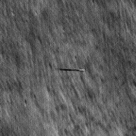
Lunar Reconnaissance Orbiter snaps a smeared image of South Korea’s Danuri lunar obiter

Danuri as seen by LRO
Click for original image.

Cool image time! On March 5 to March 6, 2024, the orbits of NASA’s Lunar Reconnaissance Orbiter (LRO) and South Korea’s Danuri orbiter had three close approaches, during which LRO had a chance to snap pictures of Danuri as it zipped by in the opposite direction.

The first image is to the right, cropped but expanded to post here.

The flight paths of the two vehicles were nearly parallel but in opposite directions, resulting in extreme relative velocity. The LROC NAC exposure time was very short, only 0.338 milliseconds. But still, Danuri was smeared by a factor greater than 10x in the downtrack direction.

…On the first opportunity, LRO was slewed 43 degrees to capture Danuri from a distance of 5.0 kilometers

Of the three pictures taken, this one appears the best. In all three cases, the fast relative speed was too fast for the camera shutter, so that Danuri’s image was smeared as you see.

Scientists: No obvious ice in the permanently-shadowed interior of Shackleton Crater

Shadowcam-LRO mosaic
Click for original image.

Using the low-light image produced by the American Shadowcam instrument on South Korea’s lunar orbiter Danuri, scientists now belief that there are no thick obvious deposits of water ice in in the permanently-shadowed interior of Shackleton Crater at the Moon’s south pole.

The image to the right combines pictures taken by Lunar Reconnaissance Orbiter (LRO) of the region around Shackleton with pictures produced by Shadowcam of its permanently-shadowed interior. From their paper’s conclusion:

The trailing (right) side of Shackleton’s interior is warmer owing to the secondary illumination asymmetry and floor topography. Illumination at the floor of Shackleton is patchy and possibly indicates a similar patchy (50 m scale) temperature distribution, which could mean a spatially irregular concentration of cold-trapped volatiles at the subsurface or mixed with regolith.

According to our Shackleton crater interior mapping from ShadowCam images, there is no observed evidence of thick ice deposits or surface ice that could be easily recognized by any relative brightness features observed in multiple illumination geometries. However, this analysis did not include the estimation of reflectance, nor did it involve reviewing all of the images of Shackleton in this preliminary study. Our hypothesis, in the context of water frost detections in Shackleton, is that if ice or frost is present in Shackleton’s interior, then the concentrations are either below the threshold that results in an observable signature in ShadowCam images, or might be mixed with the regolith at the detected areas. At other places where surface temperatures are below 110K, water frost could be hidden in subsurface layers.

The paper’s main purpose was to identify the dim lighting sources within the crater, all of which come from light bouncing off other surfaces. In the process the scientists obtained a better understanding of the surface itself.

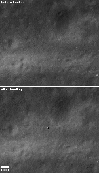
Lunar Reconnaissance Orbiter photographs SLIM on the Moon

LRO images showing before and after SLIM's landing
Click for blink animation.

Scientists using Lunar Reconnaissance Orbiter (LRO) were able on January 24, 2024 to obtain a photograph of the SLIM landing site on the Moon, and produce a before and after blink animation showing the lander on the ground.

The two pictures to the right, before and after, were taken from that animation. The bright speck in the after image is SLIM, sitting upside down on the surface. The faint streak of light material going from right to left lower in the photo comes from the fresh ejecta material thrown out from the nearby 1,425-foot-wide Shioli Crater to the west.

This picture confirms once again that SLIM achieved its main goal, landing precisely within a tiny landing zone only 300 feet across.

The landing occurred in the morning on the Moon, so the Sun was in the east. Because SLIM got flipped upside down just before touchdown, its one solar panel ended up facing west, where no sunlight could touch it. Based on the shadows in this picture, east is to the left, and west to the right. The solar panel is sitting in the shadow on SLIM’s right side.

In about a week the Sun will begin setting to the west, illuminating that panel. Engineers in Japan hope that at that time the panel will begin to recharge the spacecraft’s batteries, and it will then begin to operate again, if only a short while before the Sun sets and the very cold and hostile lunar night begins. There is little expectation of SLIM surviving that long two-week lunar night, even if it gets its batteries fully charged.

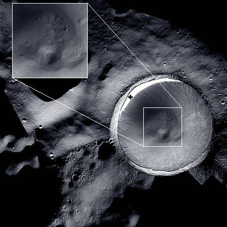
Image released of permanently shadowed floor of Shackleton Crater

Shadowcam-LRO mosaic
Click for original image.

NASA today released a mosaic combining images from Lunar Reconnaissance Orbiter’s high resolution camera LROC and the Shadowcam camera on South Korea’s Danuri lunar orbiter that shows for the first time the entire permanently shadowed floor of Shackleton Crater at the Moon’s south pole.

That mosaic, cropped, reduced, and sharpened to post here, is to the right. I have added the black cross to mark the location of the south pole, just inside Shackleton, the large crater on the right. The inset shows the floor of the crater at higher resolution.

LROC can capture detailed images of the lunar surface but has limited ability to photograph shadowed parts of the Moon that never receive direct sunlight, known as permanently shadowed regions. ShadowCam is 200-times more light-sensitive than LROC and can operate successfully in these extremely low-light conditions, revealing features and terrain details that are not visible to LROC. ShadowCam relies on sunlight reflected off lunar geologic features or the Earth to capture images in the shadows.

Thus, in the mosaic to the right the interior of Shackleton was imaged by Shadowcam, and then placed on a mosaic of LROC pictures.

If you click on the full image at high resolution and look closely at the crater floor, it is difficult to determine if there is any ice there. There are several mounds that could be ice, but could also be accumulated dirt and debris. What is most significant however is the smooth interior walls of the crater. It appears it will very possible for a rover to drive down those walls and into Shackleton.

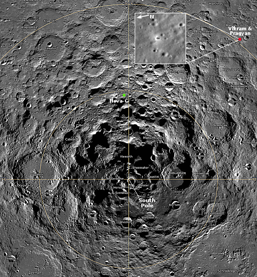
LRO takes image of Vikram on Moon


Click for interactive map. To see the original
image, go here.

The science team for Lunar Reconnaissance Orbiter (LRO) yesterday released an oblique image taken of India’s Vikram lander, on August 27, 2023, four days after the lander touched down about 370 miles from the south pole.

The LROC (short for LRO Camera) acquired an oblique view (42-degree slew angle) of the lander. … The bright halo around the vehicle resulted from the rocket plume interacting with the fine-grained regolith (soil).

That image is shown in the inset to the right. I have cropped it to focus on Vikram itself, which is in the center of the inset, with its shadow to its right, the opposite of all the surrounding craters. Pragyan is in this image, but neither it nor its tracks appear visible. The rover had moved west from the lander, which would be downward to the line of three craters near the bottom of the inset. To get a better sense of Pragyan route, compare this image with the map India’s space agency ISRO released on September 2nd.

Shadowcam on South Korea’s Danuri lunar orbiter sees no obvious ice in the permanently shadowed interior of Spudis crater

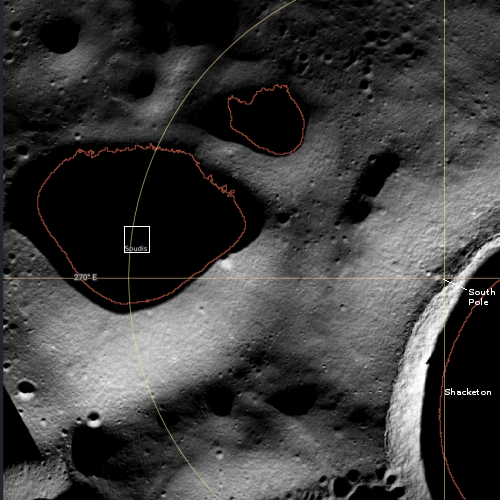
Overview map

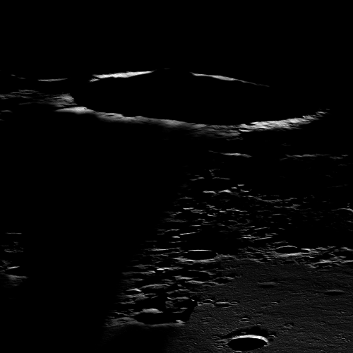
Using Shadowcam, a camera built by Arizona State University that is on South Korea’s Danuri lunar orbiter and is designed to see into very dark regions of little light, scientists have obtained optical images showing the permanently shadowed interior of Spudis Crater, located only about ten miles from the Moon’s south pole.

That picture is below. To the left is an annotated overview created from Lunar Reconnaissance Orbiter (LRO) high resolution images. The white box inside Spudis Crater indicates the area covered by the section of the Shadowcam image I have focused on. The red outlines indicate areas that are thought to be permanently shadowed. The relatively flat ridgeline between Shackleton and Spudis is one of the prime future landing sites for NASA’s Artemis program.
» Read more

Ispace publishes results of its investigation into Hakuto-R1 lunar landing failure

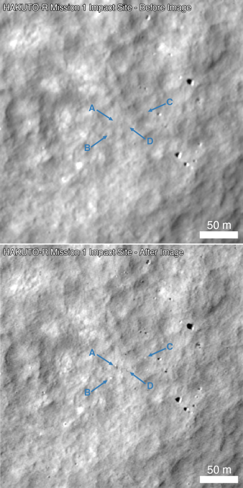
Hakuto-R1 impact site, before and after
Before and after images of Hakuto-RI, taken by Lunar Reconnaissance
Orbiter (LRO). Click for original blink image.

Ispace today published the results of its investigation into the failure of its Hakuto-R1 lunar landed to touch down on the moon successfully, stating that the cause was a software error which thought the spacecraft was closer to the ground than it was.

At the end of the planned landing sequence, it approached the lunar surface at a speed of less than 1 m/s. The operation was confirmed to have been in accordance with expectations until about 1:43 a.m., which was the scheduled landing time.

During the period of descent, an unexpected behavior occurred with the lander’s altitude measurement. While the lander estimated its own altitude to be zero, or on the lunar surface, it was later determined to be at an altitude of approximately 5 kms above the lunar surface. After reaching the scheduled landing time, the lander continued to descend at a low speed until the propulsion system ran out of fuel. At that time, the controlled descent of the lander ceased, and it is believed to have free-fallen to the Moon’s surface.

The company believes the software got confused when the spacecraft crossed over the rim of Atlas Crater.

The resulting crash produced the debris seen by LRO to the right.

Lunar Reconnaissance Orbiter spots Hakuto-R1 impact debris on Moon

Hakuto-R1 impact site, before and after
Click for original blink image.

NASA’s Lunar Reconnaissance Orbiter (LRO), scientists have spotted what they think is the impact debris produced when Ispace’s private lunar lander Hakuto-R1 crashed on the Moon on April 25, 2023.

To the right are two LRO images, the first at the top taken prior to Hakuto-R1’s landing attempt. The second at the bottom was acquired by LRO on April 26, 2023, the day after that attempt. The lettered arrows indicate four spots where the scientists identified changes between the two pictures. From the caption:

Arrow A points to a prominent surface change with higher reflectance in the upper left and lower reflectance in the lower right (opposite of nearby surface rocks along the right side of the frame). Arrows B-D point to other changes around the impact site.

According to the LRO science team, these changes suggest different pieces of debris, though it will take more analysis and more images under different lighting conditions to determine more precisely what they have found.

The presence however of four pieces strongly suggests that Hakuto-R1 hit the ground hard enough to break apart. Based on the initial data received during landing, it was thought the spacecraft had touched down softly but then was damaged by some unforeseen obstacle on the ground, such as a large boulder. The LRO image suggests instead that it did not touch down softly at all.

Capstone does lunar fly-by, takes first lunar pictures, completes main mission

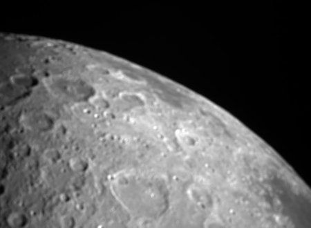
The Moon as seen by Capstone
Click for original image.

The smallsat engineering test lunar orbiter Capstone has now successfully ended its primary mission, completing six months of operation in the near-rectilinear halo orbit that NASA’s Lunar Gateway manned space station intends to fly.

To put a final touch on that main mission, in May mission managers at the private company Advanced Space also completed two additional experiments. On May 3, 2023 they performed a close-fly of the Moon, using the spacecraft’s camera for the first time to take the picture of the Moon to the right.

Then, on May 9 Capstone successfully tested navigation technology in conjunction with NASA’s Lunar Reconnaissance Orbiter (LRO), also in orbit around the Moon.

During the May 9 experiment, CAPSTONE sent a signal to LRO designed to measure the distance and relative velocity between the two spacecraft. LRO then returned the signal to CAPSTONE, where it was converted into a measurement. The test proved the ability to collect measurements that will be utilized by CAPS software to determine the positioning of both spacecraft. This capability could provide autonomous onboard navigation information for future lunar missions.

The mission now enters its extended mission, planned to last at least a year.

The Earth hangs above the Moon

The Earth hangs above the Moon

Cool image time! The picture to the right, cropped, reduced, and enhanced to post here, was taken by Lunar Reconnaissance Orbiter (LRO) on December 10, 2015 and released by the LRO team this week. From the caption:

LRO slewed to the east as it passed over the northwest rim (-8.536°N, 251.028°E, 82 km altitude) of the Orientale basin and snapped this spectacular Earth-Moon sequence with the NAC and WAC [cameras]. Tropical Cyclone Bohale is visible in the center of the image. MODIS (onboard the NASA Aqua satellite) imaged the same storm 3 hours after LRO.

The NAC and WAC images of the Earth were projected using a Point-Perspective projection to recreate the view one would see from the LRO spacecraft while taking the NAC image. Due to the relatively slow speed of the spacecraft slew, many NAC framelets of the Earth were acquired. All these WAC frames were oversampled and averaged, enabling a “super-resolution” color image (115 pixels across!), which was then combined with the 4000-pixel-wide NAC image.

…[For the Earth:] North is to the left, Antarctica to the right, Australia at the top, and Africa at the bottom

NAC and WAC are names of two different LRO cameras, one of which captured the Earth in high resolution color while the other captured the Moon. The two images were then combined, superimposing the Earth at the right size onto the second lunar image.

As noted in the caption, this view is as LRO sees the Earth from Lunar orbit, while taking a slewed oblique image of the Moon. It however is not how things would look if you were standing on the surface of the Moon. For one, the photo is zoomed in to get details on the lunar surface, making the Earth appear much larger.

For another, the image is taken 82 kilometers or 51 miles above the Moon. This higher altitude changes the position of the Earth relative to the Moon, making it appear farther from the horizon.

To a person standing in Orientale basin at 8 degrees south latitude (near the equator), but also near the edge of the visible near side of the Moon, the Earth would likely be very close to the horizon, but much smaller. To get a comparable view of the Earth, the person would likely need to use binoculars.

Orientale basin is mostly on the far side of the Moon, though it was known to exist before the space age because ground-based telescopes could see it on the edge of the visible face. It was only with the first lunar orbiters was the basin imaged from directly above, revealing its large size and distinct concentric rings forming its several circular rims.

At this location, the Earth would essentially always remain at approximately the same spot in the sky, though its illuminated face would wax and wane, like the Moon’s does, during the Moon’s twenty-eight day-long day.

A lunar lava avalanche three miles wide and one mile long

A lunar lava avalanche three miles wide and one mile long

Cool image time! The picture to the right, cropped, reduced, and sharpened to post here, was taken October 16, 2016 and released today by the Lunar Reconnaissance Orbiter (LRO) science team. It shows a three-mile-wide unnamed crater that impacted on the rims of two other lunar impacts, one larger but the other monumental.

The trio of impact events that resulted in this spectacular corner of the Moon occurred over nearly four billion years of lunar history; first, the Orientale basin (>3.7 billion years), Lowell W (one to three billion years), and finally, this unnamed crater (likely <100 million years).

The Orientale Basin is about 500 miles wide, and is one of the most distinct large features on the lunar surface, a gigantic bowl with three concentric rings surrounding it. Because it is near the eastern limb of the near side, it wasn’t until the space age before a good overhead view of this major lunar geological impact basin was seen. Lowell W is about 11 miles wide.

The overview map below shows the context between Lowell W and this small crater, with the yellow lines indicating the area covered by the picture above.
» Read more

The steep interior rim of Aristarchus Crater

Aristarchus Crater
Click for larger image.

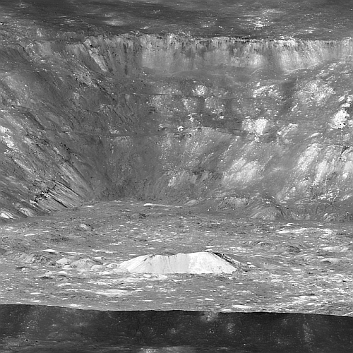
Cool image time! The photo to the right, cropped, reduced, and sharpened to post here, is a just released image taken by Lunar Reconnaissance Orbiter, looking across the top of Aristarchus Crater on the Moon from a height of only 60 miles, with the dark surrounding plateau in the foreground contrasting sharply with the bright crater interior. For scale, the distance from the floor of the crater to the top of the rim is about 9,000 feet. The bright central peak is about 1,300 feet tall. The contrast in brightness inside and outside the crater is explained thus:

Adjacent to Aristarchus crater is the Aristarchus plateau, one of the largest volcanic centers on the Moon. Here we find one of the largest rilles [on the Moon, dubbed Vallis Schröteri], a massive pyroclastic deposit, and the source of extensive flood basalts.

These volcanic materials are considered relatively young (for the Moon) – 1.5 to 2.5 billion years. The pyroclastic deposit formed when magma was explosively ejected from the vent and broke into small droplets quenched as glass in the cold vacuum of space as they fell back to the surface. Due to their high glass content, the pyroclastic deposits are distinctly low in albedo (relatively dark), providing a dark background for the bright Aristarchus crater. Within the crater, some of these pyroclastic deposits may be visible as the darkest areas on the far wall, and glassy impact melt is moderately lower in reflectance than the bright, rocky materials exposed on areas of the crater floor and walls.

The overview map below shows both the crater and the vent from which Vallis Schröteri belched.
» Read more

Streaks on the Moon

Streaks on the Moon
Click for full image.

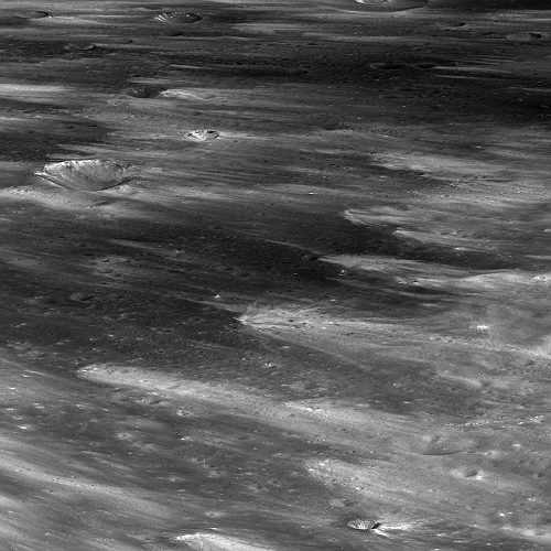
Cool image time! The photo to the right, reduced and enhanced to post here, is an oblique view taken by Lunar Reconnaissance Orbiter (LRO) of the rays that were created when four million years ago an object smashed into the Moon’s far side and produced the 13.75 mile-wide Giordano Bruno crater.

Rays are formed as material ejected from an impact event slams into the surface and churns up local material. Rays are bright because they expose fresh material from depth (both the incoming material and locally churned soil). What is fresh material? Over time the lunar surface is impacted by micrometeoroids and bombarded by radiation; both processes work to darken the surface. The dark “mature” layer at the surface is often only about 50 cm (20 inches) thick, so energetic impacts can easily bring up fresh material from the subsurface. Eventually, the bright rays darken and fade into the background as the surface matures.

In this image, you can see where the ejecta blocks from Giordano Bruno hit the surface, creating a secondary crater, which dug up local material and spread that bright material downstream (so to speak).

The image itself is 4.78 miles wide, at its center, and was snapped from an altitude of 66 miles.

Volcano on the Moon

Wide shot of lunar volcano

Close-up of lunar volcano
Click for full image.

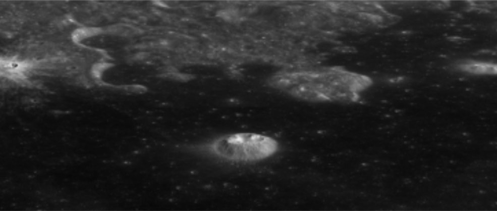
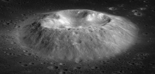
Cool image time! The Lunar Reconnaissance Orbiter (LRO) science team today released the oblique image above and in close-up to the right, showing what they call a “silicic volcano.” From the release:

The Mairan T dome is a large silicic volcanic structure with a pronounced summit depression. Remote sensing indicates that the composition of the volcanic material (lava) making up the dome is enriched in silica (SiO2). This rock type would be classified as either rhyolite or dacite on Earth, and the composition starkly contrasts with the dark, iron-rich mare basalts that embay the Mairan T dome. Most of the volcanism on the Moon is basaltic or iron-rich. Still, silicic volcanism also occurred on the Moon. Indeed, bits and pieces of similar materials were found in the Apollo samples; however, all are small fragments delivered to the Apollo sites as material ejected from distant impact events.

One of the great questions for lunar science is how the silicic materials formed. On Earth, specific tectonic settings and higher water contents in the rocks favor the formation of such lavas; however, the Moon lacks plate tectonics and water-rich sediments. NASA is planning a Commercial Lunar Payload Services (CLPS) lander mission to another, larger silicic volcano, one of the Gruithuisen domes, to address this question.

The scientists also note that this volcano formed first, and then was partly covered by the dark flood lava that surrounds it.

Lunar mountains and wrinkle ridges

Montes Recti on the Moon

Cool image time! The photo above, taken by Lunar Reconnaissance Orbiter (LRO), was released today by the orbiter’s science team, and provides us an oblique look at the mountains dubbed Montes Recti (lower right) and the wrinkle ridges near them (lower left). The highest point in this mountain range is about 5,900 feet high.

The image looks west across the northern part of the mare region dubbed Mare Imbrium, the dark area on the Moon’s visible hemisphere near its top. In the distance can be the mountains that form part of mare’s rim. The rounded peak in the top right is Promontorium Laplace (about 8,530 feet high). It is named this because it projects out (a promontory) into the mare a considerable distance from the rim. The crater at top center is Laplace D. As for the wrinkle ridges, the scientists describe them like so:

Tectonic landforms are those formed by forces that act to either contract or pull apart crustal materials. These forces develop faults or breaks in the crustal materials, and movement or slip along the faults form either positive or negative relief landforms. On the Moon, positive relief contractional landforms are the most common. The most significant contractional landforms on the Moon are wrinkle ridges, found exclusively in the dark mare basalts.

Essentially, something caused the ground to contract, which caused it to break at these ridges and be forced upward.

Dawn on the Moon

Dawn on the Moon's far side
Click for full image.

Cool image time! The photo to the right, reduced to post here, was taken on August 25, 2019 by Lunar Reconnaissance Orbiter (LRO). It shows an oblique view looking west just after lunar dawn of an unnamed 13-mile-wide crater in Mare Moscoviense on the far side of the Moon. From the caption:

Mare Moscoviense is one of the few volcanic plains on the farside, which is largely comprised of ancient cratered highland terrain. The fact that the farside was strikingly different from the familiar nearside was a surprise when the Soviet Luna 3 spacecraft returned the first farside images in 1959. The highland crust is thicker on the farside than on the nearside, which is thought to have inhibited magmas from reaching the surface as frequently as they once did on the nearside.

As seen in the image above, Mare Moscoviense lies within a large impact basin, the formation of which thinned the local crust, perhaps making it easier for lavas to erupt that would have otherwise stalled below the surface. But why does this global asymmetry in crustal thickness exist? This is still a mystery, like the origins of the large-scale asymmetries observed on Mars and Mercury, though ideas like a giant impact event that stripped off a portion of the crust or asymmetric overturn of the mantle have been proposed.

Note the dark shadow obscuring the foreground on the left. It appears from the topography in the overhead map at the link that the ridgeline that marks the eastern border of Mare Moscoviense is just high enough at dawn to keep the mare in shadow while allowing the sun’s dawn light to peek over and illuminate the crater’s rim. That ridgeline however only extends so far to the north, thus allowing sunlight to hit the plains on the right sooner.

Apollo 16 on Moon, as visualized by Lunar Reconnaissance Orbiter

In celebration of the fiftieth anniversary of the Apollo 16 mission to the Moon in April 1972, scientists using images from Lunar Reconnaissance Orbiter (LRO) have created a short digital visualization of the lunar surface where astronauts John Young and Charles Duke completed three different excursions across the lunar surface.

I have embedded that video below. The audio is the discussion between John Young and the capcom at mission control during the last excursion. The key moment is when John Young reaches the rim of North Ray crater, and realizes he cannot see its floor because the interior slopes are so steep.
» Read more

The most valuable real estate on the Moon

The most valuable real estate on the Moon
Click for full image.

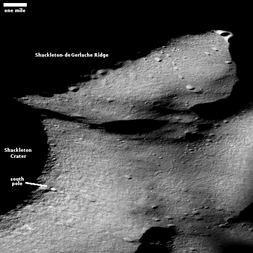
Cool image time! The photo to the right, reduced and annotated to post here, is an oblique view of the terrain near Shackelton Crater and the Moon’s south pole, taken by Lunar Reconnaissance Orbiter (LRO) and released today.

Shackleton-de Gerlache ridge, about 9 miles long, is considered one of the prime landing sites for both a manned Artemis mission as well as the unmanned Nova-C lander from the commercial company Intuitive Machines. To facilitate planning, scientists have created a very detailed geomorphic map [pdf] of this region. As explained at the first link above,

Going back to time-proven traditions of the Apollo missions, geomorphic maps at a very large scale are needed to effectively guide and inform landing site selection, traverse planning, and in-situ landscape interpretation by rovers and astronauts. We assembled a geomorphic map covering a candidate landing site on the Shackleton-de Gerlache-ridge and the adjacent rim of Shackleton crater. The map was derived from one meter per pixel NAC image mosaics and five meters per pixel digital elevation models (DEM) from Lunar Orbiter Laser Altimeter (LOLA) ranging measurements.

Such geology maps guide planning and exploration, but actual images tell us what the first explorers will see. Below is a close-up overhead view of small area at the intersection of the ridge and the rim of Shackleton.
» Read more

Fiftieth anniversary of Apollo 14 lunar landing

Apollo 14 as seen by LRO
Click for full image.

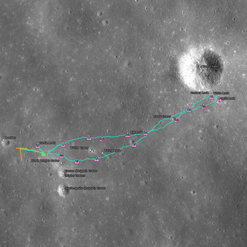
In honor of the fiftieth anniversary today of the landing of Apollo 14 on the Moon, the Lunar Reconnaissance Orbiter (LRO) science team has used images from the spacecraft to map out what the astronauts did on the surface, as shown in the reduced image to the right. The orange and teal lines indicate the routes followed during the two EVAs, with the pink triangles indicating stopping points along the way.

Unlike Apollo 11 and 12, which focused on engineering goals such as landing precisely on the Moon, Apollo 14 focused on addressing science goals. Antares (lunar module) landed in the Fra Mauro highlands, the original destination of the failed Apollo 13 mission, essentially taking on that mission’s objectives. This was the first crewed landing in the lunar highlands and not in the mare.

The Apollo 14 astronauts who landed on the Moon, Alan Shepard (Commander) and Edgar Mitchell (Lunar Module Pilot), completed two extra-vehicular activities (EVAs) while on the surface. They spent a total of 9 hours and 22 minutes setting up equipment, taking photographs, collecting samples, and exploring.

This was the last mission where the astronauts had to walk. The next three Apollo missions brought a rover with them, so that they could drive to their research sites.

The conjunction of Jupiter and Saturn, as seen from the Moon

Jupiter and Saturn as seen by LRO
Click for full image.

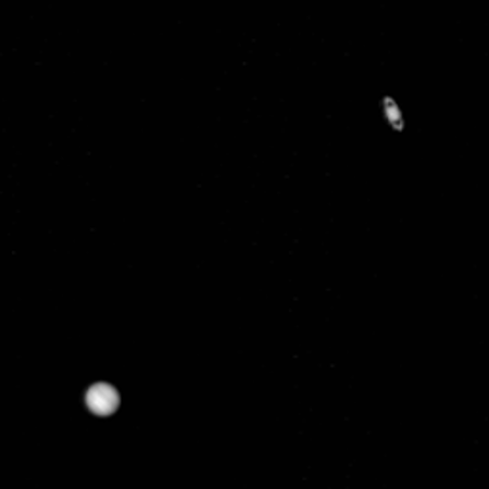
With Jupiter and Saturn closer to each other in the sky than they have been in about 800 years, the science team for Lunar Reconnaissance Orbiter (LRO) decided to aim that lunar orbiter at the two gas giants to get a picture.

The photo to the right, cropped and expanded to post here, was also enhanced by the science team to brighten Saturn so that it would match Jupiter. As they note at the link,

[LRO] captured this view just a few hours after the point of closest separation (0.1°) between the two giant planets. With the sharp focus of the NAC [camera], you can see that the two planets are actually separated by about 10 Jupiter diameters

Both planets however look fuzzy in the image, probably because the camera was not designed to obtain sharp images from this distance. Nonetheless, this is a very cool photo.

LRO snaps picture of Chang’e-5 on Moon

Chang'e-5 on the Moon, taken by LRO
Click for full image.

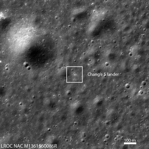
The science team for Lunar Reconnaissance Orbiter (LRO) late yesterday released an image taken of Chang’e-5 on the surface of the Moon. The image to the right, reduced to post here, is that photo.

China’s Chang’e 5 sample return spacecraft made a safe touchdown on the lunar surface at 10:11 EST (15:11 UTC) 01 December 2020. LRO passed over the site the following day and acquired an off-nadir (13° slew) image showing the lander centered within a triangle of craters.

The LROC team computed the coordinates of the lander to be 43.0576° N, 308.0839°E, –2570 m elevation, with an estimated accuracy of plus-or-minus 20 meters.

If all goes well, the return capsule, which lifted off from the Moon yesterday, will dock with the return vehicle in orbiter later today.

LRO looks at Yutu-2

Yutu-2's travels on the Moon through October 2020
Click for full image.

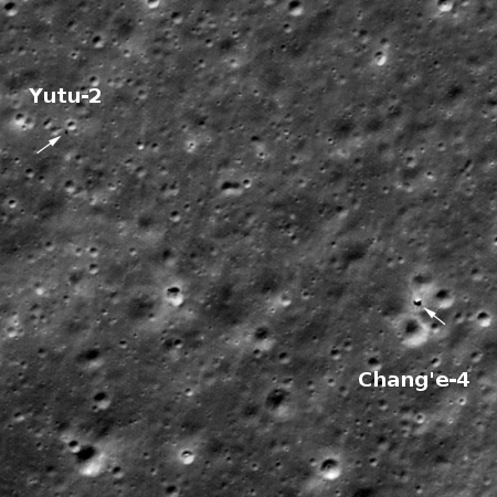
The new colonial movement: The Lunar Reconnaissance Orbiter (LRO) science team today released an update of the travels of China’s Yutu-2 lunar rover, presently operating on the far side of the Moon.

The photo to the right, reduced and annotated to post here, shows the rover’s present position, having traveled about 1,650 feet to the northwest in the 22 months since landing. The goal, according to Yutu-2’s science team, is to get the rover beyond the present ejecta field of debris thrown from a large impact to the north, and reach a basalt covered region about a mile away. At the pace they are setting, about 100 feet per lunar day, it is going to take them about another three years to get there. Whether the rover will last that long is the question, but I suspect they are hopeful, based on the almost two years of operations so far.

If you go to the link you can also see a short movie showing month-by-month where the rover ended up when it shut down for each long lunar night.

Weird crater on Moon

Strange Ryder Crater on the Moon
Click for full image.

The photo to the right, released today by the science team of Lunar Reconnaissance Orbiter (LRO), takes a overhead view of the unusual crater dubbed Ryder (named after lunar scientist Graham Ryder).

The crater is located on the Moon’s far side, on the edge of the South Pole-Aitken Basin, the Moon’s largest and possibly oldest impact basin. What makes Ryder Crater intriguing is its strange shape, as well as its interior north-south interior ridge.

This crater was featured previously in 2012 in a spectacular oblique image looking east across the crater. Then, the scientists theorized its strange shape was caused by two factors, first that the impact was oblique, and second that it occurred on a steep slope.

Today’s release adds another factor that might explain the interior ridge. The context map below makes that explanation obvious.
» Read more

1 2 3