
Detection of the wake of Betelgeuse’s companion star
Astronomers believe they have detected evidence of the wake created by Betelgeuse’s companion star as it plows through the primary star’s vast atmosphere.
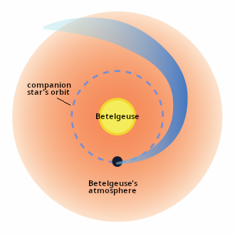
You can read their paper here [pdf]. The cartoon to the right, annotated by me to post here, is figure 5 of the paper, looking down at Betelgeuse’s pole. It is not to scale. The scientists have nicknamed the companion Siwarha.
The team detected Siwarha’s wake by carefully tracking changes in the star’s light over nearly eight years. These changes show the effects of the previously unconfirmed companion as it plows through the outer atmosphere of Betelgeuse. This discovery resolves one of the biggest mysteries about the giant star, helping scientists to explain how it behaves and evolves while opening new doors to understanding other massive stars nearing the end of their lives.
Located roughly 650 light-years away from Earth in the constellation Orion, Betelgeuse is a red supergiant star so large that more than 400 million Suns could fit inside. Because of its enormous size and proximity, Betelgeuse is one of the few stars whose surface and surrounding atmosphere can be directly observed by astronomers, making it an important and accessible laboratory for studying how giant stars age, lose mass, and eventually explode as supernovae.
Using NASA’s Hubble and ground-based telescopes at the Fred Lawrence Whipple Observatory and Roque de Los Muchachos Observatory, the team was able to see a pattern of changes in Betelgeuse, which provided clear evidence of a long-suspected companion star and its impact on the red supergiant’s outer atmosphere. Those include changes in the star’s spectrum, or the specific colors of light given off by different elements, and the speed and direction of gases in the outer atmosphere due to a trail of denser material, or wake. This trail appears just after the companion crosses in front of Betelgeuse every six years, or about 2,100 days, confirming theoretical models.
Betelgeuse is essentially a giant blob that undulates like a blob of water floating in weightlessness on ISS. Knowing the location and orbit of this companion will help astronomers better understand the central star’s periodic inexplicable changes.


