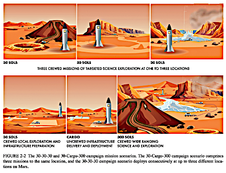
Looking for avalanches on Mars

Avalanche scarp on Mars

Cool image time! The picture to the right, rotated, cropped, reduced, and enhanced to post here, was taken on September 24, 2025 by the high resolution camera on Mars Reconnaissance Orbiter (MRO).

The science team labels this as an “avalanche scarp”. At first glance it appears we are looking at a major mass wasting event flowing downward to cover the lighter banded terrain near the bottom of the picture.

The problem is that the overlying material didn’t move as an avalanche down onto that lighter material. Note that it has within it its own layers. To have flowed over that lower terrain it would have had to do that coherently, its many layers moving in unison. This doesn’t seem probable, though who knows considering the alien nature of Mars.

So what is going on? And why was this picture taken?
» Read more

0 comments

Cracking scallops in the Mars

Cracking scallops on Mars
Click for original image.

Cool image time! The picture to the right, cropped to post here, was taken on September 27, 2025 by the high resolution camera on Mars Reconnaissance Orbiter (MRO).

The science team labels this “scallop-hosting mantle”. In other words, the surface here has a mantle of material that is for a variety of reason cracking and producing these north-facing scallops. That mantle also appears layered, since it descends downward in terraced steps as you travel north. This particular terrace drops about 40 feet.

Scientists believe [pdf] these scallops are formed in connection with the sublimation of underground ice.

According to [one hypothesis] scallop formation should be ongoing at the present time. Sublimation of interstitial ice could induce a collapse of material, initially as a small pit, then growing southward because of greater solar heating on the southern side. Nearby scallops would coalesce together as can be seen to have occurred.

In the case of the image to the right, this sublimation is also accompanied by a drying process similar to cracks one sees in dried mud. As the ice sublimates away the remain material shrinks and cracks.
» Read more

0 comments

Perseverance moves on

Perseverance panorama, November 16, 2025
Click for high resolution version. For original images, go here, here, and here.

Overview map
Click for interactive map.

Cool image time! It appears that during the government shutdown the science team for the Perseverance rover on Mars made the decision to leave an area they had been exploring for the past two months, driving the rover aggressively to the southwest and in a direction that had been unplanned.

The overview map to the right illustrates that move, with the blue dot marking the rover’s present position. The white dotted line indicates its actual travels, while the red dotted line shows the planned route. According to that planned route, the plan had been to move south and back up onto the top of the rim of Jezero Crater. For reasons that the science team has not explained, they decided instead to head to the southwest, away from the crater rim.

The panorama above was created by stitching together three images released today by Perseverance’s left navigation camera (see here, here, and here). The yellow lines on the overview map indicate my guess as to the area covered by this panorama. Note Perseverance’s tracks on the left. I think this panorama shows us the area the rover traveled in this recent move.

Note also the barrenness of the terrain. This is truly an alien world. It has an atmosphere that produces a very faint wind, that over eons can erode things. This is why this exterior wall of the rim of Jezero crater is so relatively smooth. Crater rims are usually places of jagged broken rock, thrown out by the impact. That very thin Martian atmosphere over time has smoothed that terrain.

This landscape also has no life. Except for some spots in the polar regions, it is literally impossible to find any place on Earth so devoid of life.

2 comments

The orbital propulsion module for India’s Chandrayaan-3 lunar lander drifts back into lunar orbit

When India’s Chandrayaan-3 spacecraft arrived in lunar orbit in August 2023, it separated into three units, the lander, a lunar orbiter, and a propulsion unit used to get everything to the Moon.

While the Vikram lander successfully touched down several hundred miles from the Moon’s south pole and the Chandrayaan-3 orbiter continues to make observations of the Moon, in October 2023 engineers had the propulsion module do a burn that sent it out of lunar orbit and into an Earth orbit that was close to one of the Lagrange points where the gravity of the Earth and Moon are balanced.

Now, three years later, that module has drifted back into lunar orbit, where it has since done two close fly-bys of the surface.

This intricate orbital dance culminated when the module once again entered the Moon’s SOI [sphere of influence] on November 4, 2025, an event marking the transition where lunar gravity dominates its motion.

The first recorded lunar flyby occurred on November 6, 2025, at a distance of 3,740 km from the lunar surface, though it was outside the Indian Deep Space Network’s (IDSN) visibility range. A second, closely monitored flyby took place on November 11, 2025, bringing the module within 4,537 km of the Moon and well within observation capabilities.

These events noticeably altered the satellite’s orbital parameters, expanding its orbit size from 100,000 x 300,000 km to a massive 409,000 x 727,000 km and shifting its inclination from 34° to 22°.

It is not clear what happens next. Having this module in lunar orbit could be an issue for present and later orbiters, as no orbit around the Moon can ever be stable. At some point India’s space agency ISRO needs to properly dispose of this unit, either by sending into the Moon or out of the Moon-Earth system entirely. I am of course assuming it has the fuel to do so.

2 comments

Comet C/2025 K1 — NOT interstellar 3I/Atlas — breaks up as it passes closest to the Sun

The broken apart nucleus of Comet 3I/Atlas
Click for original image.

CORRECTION: I originally posted this story thinking the comet imaged was the interstellar Comet 3I/Atlas. It is not. It is a different one. I have changed to post below to correct my error.

——————
Sometime on November 11, 2025, the nucleus of interstellar C/2025 K1 broke into three pieces as it passed through its closest and hottest point to the Sun.

The image to the right, cropped and reduced to post here, comes from images of the break-up taken by the Virtual Telescope project, which gathers data from many small telescopes remotely.

From the first link, translated by Google from the Italian:

Its trajectory led it, in early October, to pass through a point of minimum distance from the Sun (perihelion) quite close to our star, about 0.33 astronomical units, just outside the orbit of Mercury. Because of this “short” distance from the Sun, it experienced high solar irradiation, which caused a significant increase in the temperature of the surface and internal layers of the nucleus.

These are precisely the conditions under which a “breakup” event is expected: depending on the internal properties of the nucleus—namely, its porosity, its state of cohesion, its composition, and the percentage of ice—it is possible that the increase in temperature could cause significant “outgassing,” a sudden and violent outflow of gaseous and dusty material, and the consequent fragmentation of the nucleus, sometimes into a few pieces of roughly similar size, sometimes into a cloud of fragments and debris that spread along the trajectory of the original comet.

…”From an initial quick analysis of the images, we can confirm that there are certainly two fairly similar pieces, whose brightness maxima are separated by approximately 2,000 km (distance projected on the star field); “Furthermore, we can intuit the presence of a third, smaller and fainter fragment to the left of the pair,” observes Mazzotta Epifani.

It will be interesting to see if the same thing happens to interstellar Comet 3I/Atlas as it makes its own pass close to the Sun.

7 comments

The earliest observations ever of a supernova exploding suggest the blast was bi-polar

Figure 4 from the paper
Click for full graphic. CSM stands for the
circumstellar matter that surrounded the star
prior to eruption.

Using the Very Large Telescope in Chile, astronomers were able to observe a supernova in its very earliest moments after eruption, the earliest yet, and determined the eruption did not flow outward in all directions, but appeared to be bi-polar, as indicated by the cartoon to the right.

To capture the snapshot of the April 2024 supernova, astronomers used the European Southern Observatory’s Very Large Telescope in Chile, which was able to look at the polarization, or orientation, of the supernova’s light. Using a technique called spectropolarimetry, the researchers used the light’s polarization to re-create the explosion’s shape in its first moments. Their results showed that the light emanated not uniformly, like the light from a typical star, but elongated, shaped like an olive.

You can read their paper here. The cartoon comes from Figure 4, and is their “most plausible” interpretation of the data.

This bi-polar shape suggests that in the initial stages of the eruption the material shot out the star’s poles, as seen routinely in planetary nebulae as well as other eruptive stars like Eta Carina. The data also suggests the initial explosion was shaped by the circumstellar material surrounding the star. Such material tends to concentrate at a star’s ecliptic, like our solar system, With less material at the poles, the initial blast favored those directions.

Theorists will now use this data point to better refine the models that attempt to explain how supernovae explode.

4 comments

Saturn’s rings, warped by one of Saturn’s moons

Daphne inside Saturn's rings
Click for original image.

Cool image time! Rather than post another Mars image, I decided today to dig into the archive left from the Cassini orbiter that circled Saturn from July 1, 2004 until September 15, 2017. The picture to the right, cropped to post here, was taken on September 13, 2017, only two days before the orbiter burned up in Saturn’s atmosphere. From the caption:

This image of Saturn’s outer A ring features the small moon Daphnis and the waves it raises in the edges of the Keeler Gap. The image was taken by NASA’s Cassini spacecraft on Sept. 13, 2017. It is among the last images Cassini sent back to Earth. The view was taken in visible light using the Cassini spacecraft wide-angle camera at a distance of 486,000 miles from Saturn. Image scale is 2.7 miles [per pixel].

The moon is traveling downward in this image. As it moves past the outer ring, its gravity causes that edge to ripple, producing the waves.

The scale will give you an idea of how big the rings of Saturn are. The Keeler Gap is at the outer edge of the A ring of Saturn, which is the outermost ring that is clearly visible using ordinary amateur telescopes. That edge however is more than 90,000 miles from Saturn. And grayish bands to the right of Daphne and the Keeler Gap are only the outer half of the A ring, which is by itself about 9,000 miles wide.

1 comment

Goldstone antenna damaged and out of service

The Goldstone antenna in California that is a major component in NASA’s Deep Space Network (DSN) that it uses to communicate with interplanetary spacecraft was damaged recently and is presently out of service, with no known date for when or even if it will be repaired.

NASA’s Jet Propulsion Laboratory confirmed Nov. 10 that the 70-meter antenna at the Deep Space Network (DSN) site in Goldstone, California, has been offline since Sept. 16, with no timetable for its return to service. “On Sept. 16, NASA’s large 70-meter radio frequency antenna at its Goldstone Deep Space Communications Complex near Barstow, California, over-rotated, causing stress on the cabling and piping in the center of the structure,” JPL said in a statement to SpaceNews. “Hoses from the antenna’s fire suppression system also were damaged, resulting in flooding that was quickly mitigated.” [emphasis mine]

This statement suggests that as workers were changing the antenna’s orientation, it was moved too far in one direction, beyond the normal limits of that piping and cabling. The immediate question that the JPL statement avoids is this: What caused the antenna to “over-rotate”? Did something fail to stop it from going too far? Or was this an example of simple human error, whereby the person rotating the antenna failed to pay attention and allowed the antenna to exceed its limits?

Either way, the loss of this antenna not only poses a serious limitation in getting data back from the various unmanned probes at Mars, Jupiter, and elsewhere, it is also a problem for the upcoming Artemis-2 mission in the spring of ’26, which will rely on the Deep Space Network to communicate with the astronauts on Orion as it goes to and from the Moon. The network’s other two antennas in Spain and Australia can pick up the slack, but the system will have less redundancy, and more important, other missions will likely have to delay communications in order to give Artemis priority.

4 comments

The edge of Mars’ north polar ice cap

The fringe of Mars' perennial ice cap
Click for original image.

Cool image time! The picture to the right, cropped, reduced, and sharpened to post here, was taken on September 29, 2025 by the high resolution camera on Mars Reconnaissance Orbiter (MRO).

The picture shows what the science team labels as a “fringe of perennial ice.” For this picture, north is down. The white stuff on the top half of the image is that perennial ice, while the dark material at the bottom is likely a mixture of dust and debris that is still impregnated with ice.

Mars is a very icy world. Orbital data now suggests that above 30 degrees latitude there is a lot of near surface ice, though it is often mixed in with the red planet’s ample dust, blown there for eons. This location however shows us a place where that ice is on the surface, and is generally pure.

That does not mean however this will be a good location to establish a colony.
» Read more

4 comments

Curiosity looks downhill at past travels

Curiosity looks downhill
Click for original image.

Cool image time! The picture to the right, cropped, reduced, and sharpened to post here, was taken on November 6, 2025 by the left navigation camera on the Mars rover Curiosity.

The picture looks north across Gale Crater, its distant rim about 20-30 miles away barely visible in the dusty atmosphere. In the foreground can be seen Curiosity’s recent tracks, showing how the science team had it travel back and forth several times, probably to check out several different interesting nearby ground features, as well as see how the ground changed by that travel. The rover has been traveling in an area called boxwork, a series of small intercutting ridges and hollows. Several of those ridges can be seen just beyond the tracks.

The red dotted line indicates my rough estimate as to the rover’s route uphill to get to this point, traveling up and to the left and following ridges just out of view.
» Read more

0 comments

Crazy layers inside a Martian crater

Crazy layers in a Martian Crater
Click for original image.

Cool image time! The picture to the right, cropped, reduced, and sharpened to post here, was taken on September 30, 2025 by the high resolution camera on Mars Reconnaissance Orbiter (MRO).

The scientists label this image with the term “layers”, but to my eye this is kind of an understatement. The geology in the top half of this picture is more than simply layers, it is an example of that unique Martian geological feature dubbed “brain terrain”, but on steroids.

No one yet knows what causes brain terrain, though scientists think it is related to the sublimation of near surface ice. Normally the tubelike formations are much smaller, only ten to thirty feet long, not hundreds of feet as we see here.

In this case the location of these features makes their formation even more puzzling, as there is no near surface ice found here.
» Read more

1 comment

Webb tracks volcanic eruptions on Io

Different Webb infrared detections of Io over time
Click for original image.

Using the Webb Space Telescope, scientists have tracked two different volcanic eruptions on Io that too place from 2022 to 2023, detecting sulfur monoxide both from those eruptions as well as sulfur from the magnetic plasma torus produced as the planet travels through Jupiter’s strong magnetic field. From the paper’s abstract:

Volcanic thermal emission was detected from Loki Patera and Kanehekili Fluctus [two volcanic vents]. The main changes in the shape of the thermal emission spectra since [Webb] observed Io in November 2022 were consistent with the continued cooling of emplaced lava flows in the Kanehekili Fluctus region, and the crust that had formed on the surface of the lava lake in Loki Patera. Images of Io in the SO 1.707 μm emission band [sulfur monoxide] show a concentration above Kanehekili Fluctus and in two regions in the northern hemisphere. The emissions are sourced from SO molecules ejected from volcanic vents. We further detected, for the first time, sulfur line emissions at 1.08 and 1.13 μm. These emissions are distributed homogeneously across a band in Io’s northern hemisphere. They are mainly produced through excitation by electrons from the plasma torus, penetrating Io’s atmosphere.

The top image to the right shows the heat signature above the two volcanoes, one to the southwest and the second to the northeast. The middle image shows the sulfur monoxide emissions detected by Webb above those volcanoes from their on-going eruptions. The bottom image shows the more diffuse sulfur emissions, mostly in the northern hemisphere, believed produce by interactions with the plasma torus.

This research also relied on data obtained by both the Keck telescopes in Hawaii and the Hubble Space Telescope.

There are of course uncertainties with these results. For example, the conclusion that the more diffuse sulfur is produced by interactions with the plasma torus is not as certain. First, those sulfur emissions still appear closely linked to the volcanoes, which suggests this still could be a source.

Second, the observations also cover only two data points in time, in 2022 and 2023. To get a more precise map of the activity on Io we really need an orbiter there observing the planet on a continuous basis, something that is at this time impossible, not only because no mission is planned but because the hostile radiation environment this close to Jupiter makes the engineering quite challenging. It is this reason why Europa Clipper is not going into orbit around Europa when it arrives there in 2031. Better to orbit Jupiter and only periodically dip into that harsh radiation environment.

2 comments

This typical cliff on Mars just happens to match the walls of the Grand Canyon

A typical Martian cliff, comparable to the Grand Canyon
Click for original image.

Cool image time! The picture to the right, cropped, reduced, and sharpened to post here, was taken on August 23, 2025 by the high resolution camera on Mars Reconnaissance Orbiter (MRO).

The label the science team gave this image, “remnant fan”, suggests the focus of research here is the fingerlike ridges on the floor of the canyon, emanating out from the cliff. These appear to be the remains of an ancient mass-wasting event, similar to an avalanche but different in that instead of it being a pile of surface material falling down the cliff, the cliff itself breaks free and slumps downward. In this case the event was so long ago that most of the slumped material has eroded away, leaving only those ridges, likely resistant to erosion because of the impact of the material from above.

If you look at the top of cliff, you can see evidence that another mass wasting event is pending. Note how the plateau floor near the cliff has dropped about 100 feet. This drop suggests that this part of the cliff has started to slump and break away from the plateau.
» Read more

2 comments

Sunspot update: Solar activity continues to decline as predicted

Another month has passed, and so it is time for my monthly update on the never-ending sunspot cycle on the Sun. using NOAA’s own monthly update of its graph of sunspot activity and annotating it with extra information to illustrate the larger scientific context.

The green dot on the graph below indicates the level of sunspot activity on the Sun’s Earth-facing hemisphere during the month of October. Not only did the number of sunspots decline from the count in the previous month, as predicted in April 2025 by NOAA’s panel of solar scientists (as indicated by the purple/magenta line), it dropped below their prediction.
» Read more

5 comments

Someone is apparently considering putting a helicopter on Starship when it goes to Mars

Potential Starship helicopter location

In my regular trolling through the images sent down from Mars Reconnaissance Orbiter (MRO), I sometimes come across things that imply truly exciting future missions. That happened when in 2019 I found a bunch of photos each labeled as a “candidate landing site for SpaceX Starship”. Without fanfare SpaceX had begun researching locations for where it intended to land Starship on Mars, in the northern lowland plains, research that it later solidified considerably.

Similarly, I have found MRO images in 2022 suggesting scientists were thinking of running a helicopter mission inside Valles Marineris, the largest canyon in the solar system. Another image in 2024 suggested that a helicopter mission might go to another region in Mars’s southern cratered highlands.

The image to the right, cropped, reduced, and sharpened to post here, is another new example of a potential Martian helicopter mission. It was taken on August 19, 2025 and is labeled provocatively “Characterize Possible Rotorcraft Landing Site.” Unlike the previous two proposed helicopter locations, however — which appeared to be aimed at uncertain NASA funding — this image’s location suggests it is far more certain, and might launch far sooner than you can imagine.
» Read more

11 comments

ISS study suggests that weightlessness impacts the eyes of men more than women

Eye flattening while in space
Astronauts who experienced changes in their
eyes (SANS) while on long missions in space

The uncertainty of science: A recent study of 30 astronauts during long term stays on ISS suggests that weightlessness impacts the shape of the eyes more in men than in women.

You can read the paper here.

In addition to changes in fluid around the brain, the team also found that a form of eye compression, a hallmark of Spaceflight Associated Neuro-ocular Syndrome known as globe flattening, was the most consistent eye change among crew members. “By far the most prevalent sign of eye changes that we observed was globe flattening, suggesting that this should be the primary monitoring target for ocular health,” Seidler said. “Interestingly, eye changes were more prevalent in males than females.”

Globe flattening, when the back of the eyeball becomes slightly indented or pushed inward, might sound minor, but it can have significant effects on vision and raise concerns for long-duration space missions.

Surprisingly, there was no strong link between brain structural changes and eye changes, suggesting that the effects on the eyes and brain may arise from distinct mechanisms rather than shared physiological cause

For the eye research, the sample was so small, 28 individuals of which only 9 were females, the researchers readily admit in their abstract that and “interpretation of these findings should be tempered by the fact that our sample included a relatively small number of females.” Nonetheless, the research did suggest that, regardless of sex, about half of all humans will experience these eye issues during long missions in weightlessness.

The results underscore the need to do artificial gravity experiments in orbit, to find out the minimum amount of gravity needed to mitigate or even eliminate these health issues. Otherwise, interplanetary travel is going to be seriously hampered, if not impossible.

4 comments

Webb captures spectacular false-color image of planetary nebula

The Red Spider Nebula
Click for original image.

Cool image time! The picture to the right, reduced to post here, was taken by the Webb Space Telescope and released this week by the European Space Agency (ESA). It shows in the near-infrared what the scientists have labeled “The Red Spider Nebula”, a planetary nebula of eruptive gases formed near the end of a star’s life.

Webb’s new view of the Red Spider Nebula reveals for the first time the full extent of the nebula’s outstretched lobes, which form the ‘legs’ of the spider. These lobes, shown in blue, are traced by light emitted from H2 molecules, which contain two hydrogen atoms bonded together. Stretching over the entirety of NIRCam’s field of view, these lobes are shown to be closed, bubble-like structures that each extend about 3 light-years. Outflowing gas from the centre of the nebula has inflated these massive bubbles over thousands of years.

Gas is also actively jetting out from the nebula’s centre, as these new Webb observations show. An elongated purple ‘S’ shape centred on the heart of the nebula follows the light from ionised iron atoms. This feature marks where a fast-moving jet has emerged from near the nebula’s central star and collided with material that was previously cast away by the star, sculpting the rippling structure of the nebula seen today.

It is theorized that a not yet detected second star circles the primary, with both acting as the blades in a blender to mix the gases and help produce these shapes.

Be sure to click on the image to see the full resolution version. It shows the details in the central region much more clearly.

4 comments

New orbital radar data confirms large ice deposits in Phelgra Mountains near Starship landing zone

Overview map

A new paper published this week used the SHARAD radar instrument on Mars Reconnaissance Orbiter (MRO) to confirm that the glacial features found everywhere within the Phlegra Mountains where one of Starship’s four prime landing sites is located contains significant quantities of very accessible pure water ice.

The red dots on the map to the right mark two of those prime landing sites, with one inside the Phelgra Mountains in a region directly studied by this paper. The numbered black dots were other images taken by MRO for SpaceX, reported here in 2020. From the paper’s abstract:

We examined mid-latitude landforms on Mars that resemble Earth’s debris-covered glaciers in a region called Phlegra Montes. Our study site is a 1,400-km-long mountain range in the northern hemisphere of Mars that houses numerous debris-covered glaciers also called Viscous Flow Features (VFFs). Using data from the SHallow Radar (SHARAD) instrument, we detected eight new glaciers and estimated the thickness and volume of ice within them as well as the thickness of the debris on top insulating the ice. Our findings suggest that the region holds around 1.2 trillion cubic meters of ice below the surface. We detected two notable types of glaciers for the first time on Mars using SHARAD: (a) a glacier system with terrace-like steps and (b) a perched “hanging” glacier on the eastern side of the mountains

The study also found that the layer of dust and debris that covers these glaciers and protects them from sublimating away ranges from 6 to 25 feet in thickness, well within reach of any future colonists.

This study only confirms what all the orbital data for the past two decades has suggested, that Mars is an icy world like Antarctica, not a dry desert like the Sahara. As the researchers themselves note in the very first line of their paper, “Mars is a frozen world where water ice is abundant above, at, and under the surface.”

Their research also confirms that SpaceX has made a good choice for its Starship prime landing sites. Though it will likely not make its first landing at site #3, because it is inside the mountains and thus more risky, expect a landing there not long thereafter.

7 comments

The alien landscape of Mars’ north polar ice cap

The strange terrain of Mars' north polar ice cap
Click for original image.

Cool image time! The picture to the right, cropped to post here, was taken on August 24, 2025 by the high resolution camera on Mars Reconnaissance Orbiter (MRO).

The camera team labels this simply as a “terrain sample,” which usually means it was not taken as part of any specific research request, but to fill a gap in the camera’s schedule in order to maintain its proper temperature. When they need to do this, they try to find interesting things to photograph, and mostly succeed.

At first glance the picture to the right does not appear that interesting. If anything it shows an endless expanse of mottled terrain, with no features of any interest at all. This sameness however is what makes this picture and landscape intriguing. What caused it to look this way?
» Read more

3 comments

New data supports theory of dark matter, but suggests inexplicably that it acts differently depending on the galaxy’s mass

The uncertainty of science: Astronomers analyzing twelve small and faint galaxies have determined that the existence of some form of mysterious undetected dark matter is necessary to explain the motions of their stars, and that another theory dubbed MOND that would make dark matter unnecessary fails to explain the data.

The authors found that the galaxies’ internal gravitational fields cannot be explained by visible matter alone, and that MOND predictions fail to reproduce the observed behaviour. They then compared their results with theoretical models that assume instead that these galaxies are surrounded by a massive halo of dark matter. Run on the UK’s DiRAC National Supercomputer facility, these dark matter models gave a much better match to the data.

Sounds good, eh? Not so fast. The research also found that large and small galaxies inexplicably interact with gravity and dark matter differently.

The research, published in Astronomy & Astrophysics, also challenges a long-standing assumption about how galaxies behave. Astronomers have long believed there is a simple link between the amount of visible matter in a galaxy and the strength of the gravitational pull it produces – known as the “radial acceleration relation.” While this relationship still holds for larger systems, the new study shows that it starts to break down in the smallest galaxies.

In other words, we don’t know enough yet to really explain the formation and behavior of galaxies. This really isn’t surprising, considering the time scales involved (billions of years) and the distances (millions to billions of light years).

7 comments
1 12 13 14 15 16 440