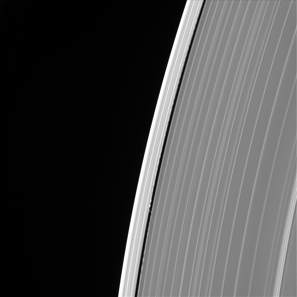
NASA approves Dragonfly mission to the Saturn moon Titan

NASA yesterday announced that it has given final approval for the Dragonfly helicopter mission to the Saturn moon Titan.

With the release of the president’s fiscal year 2025 budget request, Dragonfly is confirmed with a total lifecycle cost of $3.35 billion and a launch date of July 2028. This reflects a cost increase of about two times the proposed cost and a delay of more than two years from when the mission was originally selected in 2019. Following that selection, NASA had to direct the project to replan multiple times due to funding constraints in fiscal years 2020 through 2022. The project incurred additional costs due to the COVID-19 pandemic, supply chain increases, and the results of an in-depth design iteration. To compensate for the delayed arrival at Titan, NASA also provided additional funding for a heavy-lift launch vehicle to shorten the mission’s cruise phase.

The rotorcraft, targeted to arrive at Titan in 2034, will fly to dozens of promising locations on the moon, looking for prebiotic chemical processes common on both Titan and the early Earth before life developed. Dragonfly marks the first time NASA will fly a vehicle for science on another planetary body. The rotorcraft has eight rotors and flies like a large drone.

Be prepared for the project to go overbudget, as NASA’s biggests projects almost always do.

Engineers say goodbye to Ingenuity

Ingenuity with missing blade
Ingenuity with its missing blade. Click for original image.

Because Perseverance is about to move out of range of direct communications with the disabled Ingenuity helicopter, engineers have now completed their final transmission from the helicopter yesterday, confirming that a new software update has been successfully installed.

The telemetry confirmed that a software update previously beamed up to Ingenuity was operating as expected. The new software contains commands that direct the helicopter to continue collecting data well after communications with the rover have ceased.

With the software patch in place, Ingenuity will now wake up daily, activate its flight computers, and test the performance of its solar panel, batteries, and electronic equipment. In addition, the helicopter will take a picture of the surface with its color camera and collect temperature data from sensors placed throughout the rotorcraft. Ingenuity’s engineers and Mars scientists believe such long-term data collection could not only benefit future designers of aircraft and other vehicles for the Red Planet, but also provide a long-term perspective on Martian weather patterns and dust movement.

The engineers belief that the helicopter could collect data for as long as twenty years. That data will sit on Ingenuity until such time as a later exploration team arrives, either manned or unmanned. There is also the possibility that later in Perseverance’s mission it could pass nearby again, allowing engineers to grab some of the data then.

According to the press release, those same engineers are now exploring future helicopter missions to Mars. Based on imagery I have seen coming down from Mars Reconnaissance Orbiter (MRO), the as yet unstated target locations could be inside the eastern end of Valles Marineris or on the northern perimeter of Hellas Basin.

Isolated flat-topped mesa inside large Martian crater

Isolated flat-topped mesa
Click for original image.

Cool image time! The picture to the right, cropped and reduced to post here, was taken on February 18, 2024 by the high resolution camera on Mars Reconnaissance Orbiter (MRO).

The camera team labels this “layers in butte”, but because we are looking straight down at this 400-foot-high butte, it is difficult to see any layers at all. Based on most Martian geology however it would be shocking if this butte is not made up of multiple horizontal layers, ending with that flat surface layer at the top. Moreover, the base of the mesa to the northeast is clearly made up of a series of terraces that appear obscured at other points due to the presence of dust and dunes.

A side view would help clarify the number of layers and their thickness, but it does appear that this butte contains evidence of the geology that once covered this whole area, but over eons has eroded everything away but this butte.
» Read more

Scientists: Any ice trapped in Ceres’ permanently shadowed craters has to be very young

The permanently shadowed craters at Ceres' north pole
The permanently shadowed craters (blue) at Ceres’
north pole. Click for original image.

Scientists reviewing the archive data from the Dawn probe that orbited the asteroid Ceres from 2016 to 2018 have found that the permanently shadowed craters at the asteroid’s poles are periodically exposed to sunlight due to long term variations in Ceres’ orbit, meaning that any of the ice in those craters detected by Dawn must be extremely young.

When Ceres reaches its maximum axis tilt, which last occurred about 14,000 years ago, no crater on Ceres remains perennially shadowed and any ice in them must have quickly sublimated into space. “That leaves only one plausible explanation: The ice deposits must have formed more recently than that. The results suggest all of these ice deposits must have accumulated within the last 6,000 years or less. Considering that Ceres is well over 4 billion years old, that is a remarkably young age,” Schorghofer said.

This does not mean that Ceres doesn’t have ice. In fact, it is very ice rich, below the surface. This data instead suggests that the surface remains active, and that there are processes bringing that underground ice to the surface on a regular basis. Except for these craters, which remain permanently shadowed for long time spans, that ice sublimates away relatively quickly. This result fits with earlier data from Dawn, that suggested many active locations on the surface, including its most distinct crater, Occator.

Using Gaia data scientists discover the heaviest stellar black hole ever found

In digging into the precise motion data from the Gaia space telescope scientists have discovered the Milky Way’s heaviest stellar-sized black hole, with a mass thirty-three times the mass of our Sun.

Stellar black holes are formed from the collapse of massive stars and the ones previously identified in the Milky Way are on average about 10 times as massive as the Sun. Even the next most massive stellar black hole known in our galaxy, Cygnus X-1, only reaches 21 solar masses, making this new 33-solar-mass observation exceptional.

Remarkably, this black hole is also extremely close to us — at a mere 2000 light-years away in the constellation Aquila, it is the second-closest known black hole to Earth.

The only known black hole inside the Milky Way that is larger is Sagittarius A* (pronounced A-star), the supermassive central black hole at the galaxy’s center and weighing over four million solar masses. That creature is a very different thing, as it involves the long term evolution of the galaxy itself. Stellar-sized black holes only involve the death of a single star, with possible additions from a handful of others.

A Martian rock with holes

A Martian rock with holes
Click for original image.

Cool image time! The picture to the right, cropped, reduced, and sharpened to post here, was taken on April 13, 2024 by the high resolution camera on the Mars rover Perseverance.

The largest rock in the picture is probably only one or a few feet or so across. It has two holes, one very visible in the center and a second less obvious in the shadow on the right. What makes the obvious hole most intriguing is that it appears it was formerly entirely enclosed by the boulder, and was exposed when a section broke off. That section is the smaller rock in the foreground. I wonder if the Perseverance team will bring the rover around to get a view of that smaller rock, to see if it has its own corresponding part of this hole.

Note the smoothness of the rocks. This smoothness is very similar to what Curiosity saw when it was either on the floor of Gale Crater, or at the base of Mount Sharp. In both cases that smoothness suggests either flowing water or glacial ice erosion, like the smooth cobbles one routinely finds in streambeds or in the moraines of glaciers.

As Curiosity climbed Mount Sharp the smoothness was replaced with a delicate flaky fleecework indicating many layers but little violent erosion capable of smoothing the surface (see for example the images here and here). It appears Perseverance is still low enough in Jezero Crater to be within the ancient active region, formed from flowing water or ice.

As for the holes, my guess is that this rock formed from lava, and the holes are what geologists call “vugs”, bubbles formed within the lava as it solidified.

A Martian river of sand

A Martian river of sand
Click for original image.

Overview map
Click for interactive map.

Cool image time! The panorama above, cropped, reduced, enhanced, and flipped to post here, was taken on April 14, 2024 by the right navigation camera on the Mars rover Curiosity, created from a total of 31 images.

The full mosaic covers a full 360 degree view from where Curiosity presently sits, inside the slot canyon Gediz Vallis. The part shown above only covers a little more than half, looking west at the butte which forms the western wall of the slot canyon, as shown by the yellow lines and the arrow in the overview map to the right. The blue dot marks Curiosity’s present position, while the red dotted line its planned route.

What makes this part of the mosaic especially distinct is the narrow river of sand that flows downhill from the right to the left. While everywhere else the ground is heavily covered with rocks, along this strip the surface is smooth sand, with many frozen dunes resembling waves or ripples as the flows downhill slowly.

The river is formed against a low cliff wall, which is why the sand gathered along this strip. At the same time, the downhill grade to the left (north) is allowing the sand to carve a distinct path, at the base of that cliff.

I’ve said it before and I’ll say it again: Mars is alien, Mars is unique, but above all, Mars is wonderful.

Remember: The climate data foisted on us by NOAA is based 30% on nonexistent weather stations

The uselessness of the global temperature record

A story yesterday at Zero Hedge noted once again that the yearly global data that NOAA inflicts on us, each year claiming that a new record has been set as the hottest year ever, is all based on fake data, with about one-third of the data created from weather stations that no longer exist.

The problem, say experts, is that an increasing number of USHCN’s stations don’t exist anymore. “They are physically gone—but still report data—like magic,” said Lt. Col. John Shewchuk, a certified consulting meteorologist. “NOAA fabricates temperature data for more than 30 percent of the 1,218 USHCN reporting stations that no longer exist.”

He calls them “ghost” stations.

Mr. Shewchuck said USHCN stations reached a maximum of 1,218 stations in 1957, but after 1990 the number of active stations began declining due to aging equipment and personnel retirements. NOAA still records data from these ghost stations by taking the temperature readings from surrounding stations, and recording their average for the ghost station, followed by an “E,” for estimate.

This is not a new story. » Read more

A squeezed Martian landscape

A squeezed Martian landscape
Click for original image.

Cool image time! The picture to the right, cropped, reduced, and sharpened to post here, was taken on February 20, 2024 by the high resolution camera on Mars Reconnaissance Orbiter (MRO). It shows what the scientists label “tilted blocks in the low northern latitudes.”

At first glance this circle of tilted blocks appear to mark a place where something erupted from below, pushing and cracking the blocks away in all directions. If there was an eruption however it appears very little if anything poured out from below. Instead, the ground inside the hollow in the center is about the same elevation as the ground surrounding the tilted blocks.

Clearly some pressure from below pushed these surface blocks upward to crack and tilt, but the answer cannot be found in this close-up picture. Instead, we need to look wider, not only at the overview map below, but at the inset on that overview map.
» Read more

TESS in safe mode

NASA today revealed that on April 8, 2024 its TESS space telescope went into safe mode, for reasons that are not yet understood.

NASA’s TESS (Transiting Exoplanet Survey Satellite) entered into safe mode April 8, temporarily interrupting science observations. The team is investigating the root cause of the safe mode, which occurred during scheduled engineering activities. The satellite itself remains in good health.

The spacecraft itself remains healthy and they expect to resume science operations “in the coming days.”

That safe mode occurred while “scheduled engineering activities” were ongoing suggests that the two are linked. The lack of any details from NASA further suggests that someone did a “oops!” during those activities, and they are now scrambling to fix things.

Idiocracy has arrived

Sheila Jackson-Lee:
Sheila Jackson-Lee: “The Moon is made up
mostly of gases!””

Over the last few days the conservative press has been having a field day making justifiable fun of a number of Democrats and leftists for exhibiting incredible scientifict ignorance, an ignorance so profound as to be mind-boggling.

First, after the unusual 4.8 magnitude earthquake centered in New Jersey on April 5th, a Green Party senate candidate in New Jersey, Christina Amira Khalil, immediately tweeted, “I experienced my first earthquake in NJ. We never get earthquakes. The climate crisis is real.” The mocking on X was so great she quickly deleted the tweet.

Then, in an incredibly embarrassing segment of the television show, The View, one host, Sunny Hostin, showed off her complete lack of any scientific knowledge when she claimed that the earthquake, the solar eclipse, and even the normal arrival of the cicadas every seventeen years (which she thought happened every hundred-plus years) was evidence that climate change was real.

Finally, to top off this stream of utter empty-headiness, during an eclipse event in Texas, Congresswoman Sheila Jackson Lee gave a speech of such stunning incompetency and lack of knowledge you have to wonder how she can figure out how to put on her clothes each day. This quote has been most often used to ridicule her:
» Read more

Japan to sign deal with NASA to fly two Japanese astronauts to Moon

According to story in the Japanese press yesterday, a deal between Japan and NASA will be signed next week whereby Japan will have two astronauts go on Moon missions in exchange for providing cargo to the Lunar Gateway station as well as a manned lunar rover.

The report today is unclear whether those Japanese astronauts will land on the Moon, but I expect they will. The rover project is being led by Toyota. It will include a airtight cabin where spacesuits will not be necessary and passengers can also sleep, allowing for very long exploratory traverses from the landing site.

Reports of this deal have been appearing in the press since 2022, when NASA said it would involve flying one Japanese astronaut to the Moon. In December 2023 it was reported that the deal would be signed within a month. It is now April. It appears the extended negotiations have gotten Japan a second astronaut Moon walker.

NASA’s Artemis program is beginning to shape up as an international program for getting almost everyone to the Moon but Americans. I am exaggerating, but I think in the future Americans will find it easier to go on a private mission to the Moon than depend on NASA, especially because of all the international deals NASA will have to honor.

The foot of a Martian glacier

The foot of a Martian glacier
Click for original image.

Cool image time! The picture to the right, cropped, reduced, and enhanced to post here, was taken on February 18, 2024 by the high resolution camera on Mars Reconnaissance Orbiter (MRO). It shows what the scientists label as the “terminus of possible glacier-like feature.” That feature is at the lower left, at the point where glacier-like material appears to be flowing out of the channel from the northeast but then ending in an area of rough fingers.

That this looks exactly like a glacier does not guarantee that it is one, which is why the scientists insert the word “possible.” Nonetheless, the geology resembles that of a glacier, from the parallel lines along its length as well as its existence inside this channel. The location is also at 49 degrees south latitude, well within the mid-latitude strips on Mars where scientists believe many such glaciers exist.

The overview map below adds further weight to this conclusion. It also suggests that there are even more glaciers on Mars than research up to now has suggested.
» Read more

ESA awards Thales Alenia contract to build Mars lander for Franklin rover

Oxia Planum drainages
The drainage patterns at the Franklin rover
landing site

Click for paper [pdf].

The European Space Agency (ESA) today awarded the Italian company Thales Alenia a €522 million contract to build the entry, descent, and landing module for ESA’s Franklin rover, now scheduled for launch in 2028.

Under this contract, Thales Alenia Space will lead the definition of the Entry, Descent and Landing Module and maintenance activities for the transfer module (carrier) and the rover, including upgrades and replacement of time-sensitive elements. A full audit and tests will be carried out on the rover to ensure its readiness for the new mission. In addition, replacement of some payload elements is planned, such as integration of the new Enfys infrared spectrometer. The batteries and tanks will be replaced on the carrier module as well as potential adjustments to align with the updated trajectories to Mars. New developments on the descent module and landing pad are also required, because the European avionics part of the descent module will be reused.

This contract was necessary because the project was initially a partnership with Russia, whereby Russia provided this lander as well as the launch services. That partnership was severed after Russia invaded the Ukraine, which caused this mission to Mars to be delayed four to six years.

NASA then chipped in $30 million to help pay for launch out of Cape Canaveral, though no launch company has been announced. I suspect both ESA and NASA wish to wait before making a deal, considering how launch costs are dropping. At present it is impossible to predict the landscape of that market in 2028.

A whirlpool half-hidden by dust

A whirlpool half-hidden by dust
Click for original image.

Cool image time! The picture to the right, reduced and sharpened to post here, was taken by the Hubble Space Telescope and shows us a magnificent spiral galaxy about 100 million light years away that also has very active nucleus at its center as well as many star-forming regions (in blue) in its outer arms.

That we do not see the same blue spiral arms on the right side of the photo is not because they are lacking, but because a very large stream of dust blocks our view.

This dark nebula is part of the Chamaeleon star-forming region, itself located only around 500 light-years from us, in a nearby part of the Milky Way galaxy. The dark clouds in the Chamaeleon region occupy a large area of the southern sky, covering their namesake constellation but also encroaching on nearby constellations, like Apus. The cloud is well-studied for its treasury of young stars, particularly the cloud Cha I, which has been imaged by Hubble and also by the … James Webb Space Telescope.

Lunar Reconnaissance Orbiter snaps a smeared image of South Korea’s Danuri lunar obiter

Danuri as seen by LRO
Click for original image.

Cool image time! On March 5 to March 6, 2024, the orbits of NASA’s Lunar Reconnaissance Orbiter (LRO) and South Korea’s Danuri orbiter had three close approaches, during which LRO had a chance to snap pictures of Danuri as it zipped by in the opposite direction.

The first image is to the right, cropped but expanded to post here.

The flight paths of the two vehicles were nearly parallel but in opposite directions, resulting in extreme relative velocity. The LROC NAC exposure time was very short, only 0.338 milliseconds. But still, Danuri was smeared by a factor greater than 10x in the downtrack direction.

…On the first opportunity, LRO was slewed 43 degrees to capture Danuri from a distance of 5.0 kilometers

Of the three pictures taken, this one appears the best. In all three cases, the fast relative speed was too fast for the camera shutter, so that Danuri’s image was smeared as you see.

Today’s eclipse

The next eclipses to cross the U.S.
Map by Michael Zeiler (GreatAmericanEclipse.com). Click for original.

Today a solar eclipse will cross some of the most populated areas of Mexixo, the United States, and Canada, as shown on the map to the right.

We shall not see such an event in North America again until 2046, and that will only cover a small part of the Pacific northwest. If you have never seen such an event, get your eclipse glasses (essential if you don’t want to go blind), take some time off of work, and go see it today. This link from Sky & Telescope covers about everything you need to know.

The experience is very hard to describe, though I tried when Diane and I traveled to South Bend, Idaho, in 2017 to experience that eclipse. As I wrote,

Totality was amazing. I was amazed by two things. First, how quiet it became. There were about hundred people scattered about the hotel lawn, with dogs and kids playing around. The hotel manager’s husband set up speakers for music and to make announcements, but when totality arrived he played nothing. People stopped talking. A hush fell over everything. Moreover, I think we somehow imagine a subconscious roar from the full sun. Covered as it was, with its soft corona gleaming gently around it, it suddenly seemed still.

Secondly, the amazing unlikeliness of the Moon being at just the right distance and size to periodically cause this event seemed almost miraculous. Watching it happen drove this point home to me. And since eclipses themselves have been a critical event in the intellectual development of humanity, helping to drive learning and our understanding of the universe, it truly makes me wonder at the majesty of it. I do not believe in any particular religion or their rituals (though I consider the Bible, the Old Testament especially, to be a very good manual for creating a good life and society), but I do not deny the existence of a higher power. Something made this place, and set it up in this wonderous way. Today’s eclipse only served to demonstrate this fact to me again.

I am sure your impressions will be unique to you.

Varda quickly raises $90 million after completing its first orbital manufacturing mission

As expect, Varda announced yesterday that it raised $90 million in investment capital following the publication of the results of its first orbital manufacturing mission, where its returnable capsule was used to produce test pharmaceuticals in space that cannot be made on Earth.

Varda announced April 5 it raised a Series B round led by venture firm Caffeinated Capital, with participation from Lux Capital, General Catalyst, Founders Fund and Khosla Ventures. The company has raised $145 million to date. The funding round comes on the heels of the successful conclusion of its first demonstration mission, W-1, on Feb. 21 when the company’s capsule landed at the Utah Test and Training Range. The capsule had been part of a spacecraft launched in June 2023 to test the ability to produce pharmaceuticals in microgravity.

The new funding will allow Varda to scale up production of spacecraft that take advantage of microgravity to produce pharmaceuticals that are not possible or cost-effective to make on the ground.

The company already has a second returnable capsule scheduled for launch this summer on a Rocket Lab Electron rocket.

The taffy terrain in Mars’ death valley

Taffy terrain in Hellas Basin on Mars

Cool image time! The picture to the right, rotated, cropped, reduced, and sharpened to post here, was taken on February 21, 2024 by the high resolution camera on Mars Reconnaissance Orbiter (MRO). Labeled “banded terrain and layering,” it actually is a good example of “taffy terrain,” a weird Martian geological formation unique to the Red Planet that scientists as yet don’t quite understand. This 2014 paper only says this:

The apparent sensitivity to local topography and preference for concentrating in localized depressions is compatible with deformation as a viscous fluid. In addition, the bands display clear signs of degradation and slumping at their margins along with a suite of other features that include fractured mounds, polygonal cracks at variable size-scales, and knobby/hummocky textures. Together, these features suggest an ice-rich composition for at least the upper layers of the terrain, which is currently being heavily modified through loss of ice and intense weathering, possibly by wind.

» Read more

Voyager-1 still out of commission

Though engineers have now confirmed the cause of the computer problem that has prevented Voyager-1 from sending back readable data, a fix has not yet been attempted and the spacecraft remains in safe mode.

In early March, the team issued a “poke” command to prompt the spacecraft to send back a readout of the FDS [Flight Data Subsystem] memory, which includes the computer’s software code as well as variables (values used in the code that can change based on commands or the spacecraft’s status). Using the readout, the team has confirmed that about 3% of the FDS memory has been corrupted, preventing the computer from carrying out normal operations.

The team suspects that a single chip responsible for storing part of the affected portion of the FDS memory isn’t working. Engineers can’t determine with certainty what caused the issue. Two possibilities are that the chip could have been hit by an energetic particle from space or that it simply may have worn out after 46 years.

Although it may take weeks or months, engineers are optimistic they can find a way for the FDS to operate normally without the unusable memory hardware, which would enable Voyager 1 to begin returning science and engineering data again.

Considering that Voyager-1’s power supply will run out sometime in 2026, after almost a half century of operation, the engineers really don’t have that much time to fix the problem and resume science operations.

Engineers confirm IXPE is fixed and resuming science observations

Engineers have now confirmed the software fix they sent to the IXPE space telescope on March 26, 2024 has worked, and have taken the telescope out of safe mode so that it can resume science observations.

The IXPE mission is now observing a new transient X-ray source – Swift J1727.8–161 – a candidate accreting black hole. The source has recently begun producing jets of material moving at a fraction of the speed of light. The IXPE observations will help to understand accretion onto black holes, including potentially revealing how the relativistic jets are formed.

The telescope observes the universe in X-rays, but does so by observing its polarization. This approach provides information not seen in direct observations.

Complex ridged terrain in ancient Martian crater

Complex ridges in an ancient Martian crater
Click for original image.

Cool image time! The picture to the right, rotated, cropped, reduced, and enhanced to post here, was taken on January 16, 2024 by the high resolution camera on Mars Reconnaissance Orbiter (MRO). Because an electronic unit for one of this camera’s filters has failed, causing a blank strip in the image center, I have filled in that gap using an MRO context camera image taken October 31, 2015.

The scientists describe this geology as “ridged terrain.” What I see is a surface that was like wet plaster once, and then a giant finger touched it and pulled away quickly, so that as it left some material pulled upward to create random ridges within the depression created by that finger.

These ridges are inside a very very ancient 110-mile-wide crater dubbed Margulis. According to the 2021 poster [pdf] of the scientists who did the first geological mapping of this crater, the crater floor “show remnants of sedimentary materials, suggesting the [crater was] subjected to widespread episodes of resurfacing and denudation.”

Though located in the dry equatorial regions, this ridged terrain suggests it formed suddenly when underground ice sublimated into gas, bursting upward to break the surface when the gas pressure became high enough.
» Read more

Patches of volcanic Martian ash covering patches of frozen volcanic dunes

Patches of volcanic Martian ash over frozen volcanic dunes

Cool image time! The picture to the right, cropped, reduced, and sharpened to post here, was taken on December 24, 2023 by the high resolution camera on Mars Reconnaissance Orbiter (MRO).

What makes this terrain intriguing are the series of parallel ridges that cover most of the picture, with smaller ridges at right angles filling the hollows between. It appears we are looking at two different sets of dunes, the larger ridges indicating the southeast-to-northwest direction of the prevailing winds, while the smaller ridges in the hollows suggest the wind patterns within the hollows, causing smaller ripple dunes to form at right angles.

Note however the flat patches in the lower left. The material there appears to fill the hollows, covering the dunes. We can tell this by the hollows to the east, which have an almost identical dune pattern. Those flat patches then are likely covering similar dunes, with the patched material either having been blown away to expose the lower dunes, or having been blown here to cover them in patches. That the dunes appear unchanged under this patched material when exposed also suggests strongly that these dunes are hardened into stone, no longer soft sand that can be blown by the wind.
» Read more

Sunspot update: The weak solar maximum continues

NOAA yesterday posted its updated monthly graph tracking the number of sunspots on the Sun’s Earth-facing hemisphere. As I do every month, I have posted this graph below, with several additional details to provide some larger context.

The sunspot activity in March dropped, continuing the pattern of the last five months, where the Sun appears to be in a stable plateau after reaching a high peak in the summer of 2023. It continues to appear that we are in the middle low saddle of a double-peaked relatively weak solar maximum, with the Sun doing what I predicted in February:

If we are now in maximum, sunspot activity throughout the rest of 2024 should fluctuate at the level it is right now, with it suddenly rising again near the end of the year for a period lasting through the first half of 2025. After that it should begin its ramp down to solar minimum.

» Read more

Interacting galaxies

Interacting galaxies
Click for original image.

Cool image time! The picture to the right, reduced and sharpened to post here, was taken by the Hubble Space Telescope as part of a dark energy survey. It shows two galaxies very close together, their perpheries only about 40,000 light years apart, with the larger galaxy about the size of the Milky Way.

For comparison, the Large Magellanic Cloud (LMC) is about 167,000 light years from the Milky Way, more than four times farther that this satellite galaxy. Yet the satellite galaxy here appears much larger than the LMC, having a central core that the LMC lacks. From the caption:

Given this, coupled with the fact that NGC 5996 is roughly comparable in size to the Milky Way, it is not surprising that NGC 5996 and NGC 5994 — apparently separated by only 40 thousand light-years or so — are interacting with one another. In fact, the interaction might be what has caused the spiral shape of NGC 5996 to distort and apparently be drawn in the direction of NGC 5994. It also prompted the formation of the very long and faint tail of stars and gas curving away from NGC 5996, up to the top right of the image. This ‘tidal tail’ is a common phenomenon that appears when galaxies get in close together, as can be seen in several Hubble images.

In this single picture we are witnessing evidence of a process that has been going on for likely many millions of years.

Varda releases results of its in-orbit test for producing pharmaceuticals in weightlessness

On March 20, 2024 Varda released the results from its seven-month-long flight of its unmanned capsule, claiming that the technology worked to produce pharmaceuticals in weightlessness that will be better at treating some difficult illnesses such as HIV.

From the abstract of the preprint paper [pdf]:

Despite notable progress in realizing the benefits of microgravity, the physical stability of therapeutics processed in space has not been sufficiently investigated. Environmental factors including vibration, acceleration, radiation, and temperature, if not addressed could impact the feasibility of in-space drug processing. The presented work demonstrates the successful recovery of the metastable Form III of ritonavir generated in orbit. The test samples and passive controls containing each of the anhydrous forms of ritonavir; Form I, Form II, Form III, and amorphous exhibit excellent stability. By providing a detailed experimental dataset centered on survivability, we pave the way for the future of in-space processing of medicines that enable the development of novel drug products on Earth and benefit long-duration human exploration initiatives.

More research is likely required, but I suspect Varda will be able to raise investment capital from this success, since there is a lot of money to be made from pharmaceuticals that can only be produced in weightlessness.

The Martian view from high on Mount Sharp

The Martian view of mountains
Click for original image.

Cool image time! The picture to the right, cropped, reduced, and sharpened to post here, was downloaded today from left navigation camera on the Mars rover Curiosity.

The image looks to the north from the lower foothills of Mount Sharp. The view is downhill across the floor of Gale Crater. The intermittent dotted red line that weaves between those foothills marks the approximate route that Curiosity took to climb through them to reach this point.

About 20 to 25 miles away the mountainous rim of the crater can be seen dimly. The air is filled with dust, because its is almost the peak of the dust season at Gale Crater, located just south of the Martian equator.

The overview map below provides some further context.
» Read more

China working to save classifed lunar mission from launch failure

Orbital data now suggests that Chinese engineers are attempting to save a classifed lunar mission from the failure of its launch rocket to put the two satellites in their proper high orbit.

The small DRO-A and B spacecraft launched from Xichang spaceport on a Long March 2C rocket March 13. Hours later, the first acknowledgement of the mission came from Chinese state media Xinhua, which announced that the spacecraft had not been inserted accurately into their designated orbit by the rocket’s Yuanzheng-1S upper stage. “The upper stage encountered an abnormality during flight, causing the satellites to fail to accurately enter the preset orbit,” Xinhua stated. “Relevant disposal work is currently underway,” it added, citing Xichang launch center.

Data from the U.S. Space Force’s 18th Space Defense Squadron (SDS) initially showed objects associated with the launch in low Earth orbit (LEO). However, subsequent Two Line Element (TLE) data sets, a mathematical representation of a satellite’s mean orbit, from 18 SDS show an object from the launch (international designator 2024-048A) in a 525 x 132,577-kilometer, highly-elliptical, high Earth orbit. This has since been raised, with the spacecraft tracked in a 971 x 225,193-km orbit on March 26.

This indicates that at least one satellite, and perhaps both—if still attached to one another—separated from the upper stage, and that the object’s orbit has been raised.

It is very possible that further engine burns could put these satellites into lunar orbit, which would then save the mission and turn the March 13 launch failure into a success.

Why China is keeping this particular lunar mission so secret is another question, that still remains unanswered.

Martian waves of ridges and cracks

Martian waves of ridges and cracks
Click for original image.

In preparing today’s cool image I initially planned to post an picture taken on December 26, 2023 by the high resolution camera on Mars Reconnaissance Orbiter (MRO), as it showed a strange series of ridges that almost resembled waves or ripples on a pond.

In digging into MRO’s context camera archive to get the larger context, however, I immediately switched to the photo on the right, cropped, reduced, and sharpened to post here. Taken on December 17, 2010, it shows a much more mysterious and striking set of geological features than the closer view of the high resolution image, with the wave-shaped ridges on its western half but another set of wave-shaped cracks on its eastern half.

Even more intriguing, the arcs for the ridges curve in the opposite direction from the arcs for the cracks. It is almost as if there were two flows moving in opposite directions, right next to each other.
» Read more

1 14 15 16 17 18 274