Endless ash fields on Mars

Endless ash fields on Mars
Click for original image.

Cool image time! The picture to the right, cropped, reduced, and sharpened to post here, was taken on September 18, 2023 by the high resolution camera on Mars Reconnaissance Orbiter (MRO).

It shows the very typical surface on a high plateau in Mars’ dry tropical regions. The dunes you see here, in this very small slice, cover a region about 80 miles square, with the prevailing winds appearing to consistently blow from the northeast to the southwest and forming these endless striations.

The dunes are made of volcanic ash, and the size of this particular ash field gives us a sense of the past volcanic activity that once dominated the red planet. Once, the atmosphere was filled with ash, which covered the ground across large regions. In the subsequent eons the thin Martian atmosphere has reshaped and piled that ash into giant mounds hundreds of miles across, with the surface striated as we see here.
» Read more

Another giant star undergoes dimming

The changes seen in RW Cephei
Click for original image.

Astronomers have detected another giant star dimming in a manner similar to the dimming that Betelgeuse experienced around 2019.

Old stars display light variations that are related to changes in their outer layers. The changes are usually small, so scientists were amazed when astronomers Wolfgang Vollmann and Costantino Sigismondi announced in 2022 that RW Cephei had faded dramatically over the previous few years. By December 2022, RW Cephei had faded to about one third of its normal brightness, an unprecedented drop.

You can read the published paper here. The researchers believe the dimming was caused by the release of dust from the star, blocking its light, much as what is believed happened with Betelgeuse.

RW Cephei, like Betelgeuse, is like a giant gas bag that fluctuates in shape like blob of water in weightlessness. This blob however so big that if placed where the Sun is its surface would be about the orbit of Jupiter. As shown in the two pictures to the right taken by this research team, the shape changed during this dimming.

The star however is much farther away, 16,000 light years compared to Betelgeuse’s 550 light years. Because of Betelgeuse’s size and nearness, until recently it was the only star outside of the Sun whose actual disk had been imaged. That astronomers can now get images of a star as far away as RW Cephei illustrates the incredible improvement in astronomical technology in the past three decades.

The Surt volcano on Io

The Surt volcano on Io in close-up
Click for original image.

Cool image time! The picture to the right, rotated, reduced, and sharpened to post here, was taken by Juno during its 57th close-fly of Jupiter on December 30, 2023. It shows of one of the many volcanoes that cover and continually recoat the surface of the Jupiter moon Io.

The picture was initially processed by citizen scientist Gerald Eichstädt. Thomas Thomopoulos then zoomed in and added additional enhancements to this particular area. (I thank Thomas for his additional help in making this post happen.)

The location is an active volcano named Surt, which has been observed to erupt several times since the 1970s, with its February 2001 eruption the most powerful yet observed on Io, though the pictures by the Jupiter orbiter Galileo taken before and after revealed few significant surface changes.

The picture itself shows a region where major changes have definitely occurred. The large arc of mountains across the photo’s center suggests the remaining half of a large caldera, its northern half now either buried or destroyed. The deep obvious hole inside that crescent appears to be the main vent from which the recent eruptions have spewed, as indicated by the light-colored apron surrounding it.

In the southwest section of that large mountain arc is a distinct ridgeline with a small circular curve in its middle that suggests a former volcanic cone, its northern half now gone.

To put it mildly, Io appears a very alien place, shaped entirely and continuously by endlessly volcanic eruptions that spread lava across its entire surface repeatedly.

Layered volcanic vent on Mars

Layered volcanic vent on Mars
Click for original image.

Cool image time! The picture to the right, rotated, cropped, reduced, and sharpened to post here, was taken on August 31, 2023 by the high resolution camera on Mars Reconnaissance Orbiter (MRO), and shows what the science team labels as a “vent near Olympica Fossae.”

The grade within the fissure is downhill to its center. Outside the vent the grade is downhill to the north and south, with the overall grade sloping to the west as well. Note the layers on each side of the depression. Each indicates another volcanic flood event that laid down another layer of lava. At some point this vent either blew up through those layers, or it had remained opened during all those many events, the lava flowing out and acting like water to erode the layers on the north and the south.

As always, the scale of Martian geology is daunting, as shown by the overview map below.
» Read more

Scientists: Suspended iron minerals floating in Venus’s atmosphere explain dark UV streaks

Venus as seen in ultraviolet by Mariner 10, February 5, 1974
Venus as seen in ultraviolet by Mariner 10,
February 5, 1974

The uncertainty of science: Since the mid-1970s scientists have been trying to figure out the cause of the dark streaks seen in the atmosphere of Venus when photographed in ultraviolet. The image to the right was the first such UV image, taken by Mariner 10 during its fly-by on its way to Mercury. These streaks are caused by some unknown material that absorbs the UV light.

Researchers have now proposed that two different iron-bearing minerals, floating in Venus’s atmosphere, are what cause these dark UV streaks. From the absract:

Our results demonstrate that ferric iron can react with sulfuric acid to form two mineral phases: rhomboclase [(H5O2)Fe(SO4)2·3H2O] and acid ferric sulfate [(H3O)Fe(SO4)2]. A combination of these two mineral phases and dissolved Fe3+ in varying concentrations of sulfuric acid are shown to be good candidates for explaining the 200- to 300-nm and 300- to 500-nm features of the reported unknown UV absorber.

Iron has been detected in the atmosphere previously, and is theorized could come from volcanic eruptions on the planet’s million-plus volcanoes.

This new hypothesis explaining the dark UV absorber however remains unconfirmed, and joins a list of other candidates for that absorber, many of which propose either iron or sulfur in different combinations. Because so little data really exists about the atmosphere of Venus, with what is known also uncertain, it is presently impossible to solve this mystery with confidence. The problem is made even more difficult in that scientists understand almost nothing about the chemistry of materials under the conditions seen in Venus’s atmosphere, which is extremely hot (800 degrees Fahrenheit) and very thick and dense (100 times that of Earth).

NASA: UAE to build airlock module for lunar station plus have astronaut fly there

According to a press release from NASA today, the United Arab Emirates (UAE) will build the airlock module for the Lunar Gateway space station plus have one astronaut fly a mission to the station after it is built.

Under a new implementing arrangement expanding their human spaceflight collaboration with NASA through Gateway, MBRSC will provide Gateway’s Crew and Science Airlock module, as well as a UAE astronaut to fly to the lunar space station on a future Artemis mission.

I strongly suspect that the UAE will mostly pay for this module to be built, hiring outside contractors from either the U.S. or Europe to do the work.

Canyons formed from the giant crack that splits Mars

Canyons formed by the giant crack that splits Mars
Click for original image.

Cool image time! The photo to the right, cropped, reduced, and sharpened to post here, was taken on September 22, 2023 by the high resolution camera on Mars Reconnaissance Orbiter (MRO). It shows a complex of north-south trending canyons, with easternmost cliff about 400 feet high (though the full drop to the large canyon on its east is closer to 800 feet).

These canyons however have nothing to do with ice or water flow. They were formed by underground tectonic forces that pushed the ground upward, forced it to split and form cracks. Those cracks in turn produced these canyons. In some cases, such as the depression on top of the central ridge, the formation process probably occurred because fissures formed below ground, causing the surface to sag.

As always, the hiker in me wants to walk up the nose of that ridge and then along its western edge, with the western canyon on my left and that smaller depression on my right.

The larger context of this location is in itself even more spectacular.
» Read more

Researchers propose method for removing toxic perchlorates from Martian water

Of the twelve research grants just awarded by NASA to develop a variety of new technologies for astronomy and future space exploration, one proposes a new method for removing the toxic perchlorates that are thought to exist in all Martian water.

What if we could make the perchlorates just vanish? This is the innovative solution we propose here, taking advantage of the reduction of chlorate and perchlorate to chloride and oxygen being thermodynamically favorable, if kinetically slow. This is the promise of our regenerative perchlorate reduction system, leveraging synthetic biology to take advantage of and improve upon natural perchlorate reducing bacteria.

These terrestrial microbes are not directly suitable for off-world use, but their key genes pcrAB and cld, which catalyze the reduction of perchlorates to chloride and oxygen, have been previously identified and well-studied. This proposed work exploits the prior work studying perchlorate-reducing bacteria by engineering this perchlorate reduction pathway into the spaceflight proven Bacillus subtilis strain 168, under the control of a robust, active promoter. This solution is highly sustainable and scalable, and unlike traditional water purification approaches, outright eliminates perchlorates rather than filtering them to dump somewhere nearby.

Essentially the researchers will try to engineer bacteria known to be able to survive space so that it carries genes from another microbe able of changing the perchlorate into chloride and oxygen.

This study as well as the other eleven are only in phase one of their contracts, with the award of later phases determined by their initial successes or failures.

The mining potential on Mars

The mining potential on Mars
Click for original image.

Cool image time! The picture to the right, cropped, reduced, and sharpened to post here, was taken on October 30, 2023 by the high resolution camera on Mars Reconnaissance Orbiter (MRO). Labeled simply as a “terrain sample,” it was probably taken not as part of any specific research project but to fill a gap in the schedule in order to properly maintain the camera’s temperature.

Nonetheless, the larger region where this photo is located is one of great interest to scientists as well as to future explorers. First note the colors. The wide variations between the bright orange of that peak (only a few tens of feet high) and the light orange and aqua-green of the bedrock to the north and south suggest a terrain with a lot of different materials within it.

The location is in the dry equatorial regions, so the swirls visible on the plateaus north and south of that small peak are not related to near surface ice. Instead, this is warped bedrock, with those swirls also suggesting material of a varied nature, exposed to the surface by erosion processes.
» Read more

Hubble detects changes in atmosphere of exoplanet

Using data from collected in 2016, 2018, and 2019 combined with computer simulations, scientists now believe they have detected changes in the atmosphere of the exoplanet WASP-121b, also nicknamed Tylos.

The Jupiter-sized planet orbits a star about 880 light years away.

WASP-121 b is so close to its parent star that the orbital period is only 1.27 days. This close proximity means that the planet is tidally locked so that the same hemisphere always faces the star, in the same way that our Moon always has the same side pointed at Earth. Daytime temperatures approach 3,450 degrees Fahrenheit (2,150 degrees Kelvin) on the star-facing side of the planet.

The team used four sets of Hubble archival observations of WASP-121 b. The complete data-set included observations of WASP-121 b transiting in front of its star (taken in June 2016); WASP-121 b passing behind its star, also known as a secondary eclipse (taken in November 2016); and the brightness of WASP-121 b as a function of its phase angle to the star (the varying amount of light received at Earth from an exoplanet as it orbits its parent star, similar to our Moon’s phase-cycle). These data were taken in March 2018 and February 2019, respectively.

A computer model was then used to fill in the gaps and provide a simulation of the hot temperatures of that exoplanet’s atmosphere over time. Two videos of that simulation are available at the link.

There of course is a lot of uncertainty in this result, though the fundamental discovery of changes is important. This data proves there is weather on such alien planets, even if that weather is so alien we really don’t understand it in the slightest based on the available data on hand.

Sunspot update: Are we now in the next solar maximum?

Time for my monthly update on the Sun’s sunspot activity has it proceeds through its eleven-year sunspot cycle. NOAA has released its update of its monthly graph showing the number of sunspots on the Sun’s Earth-facing hemisphere, and I have posted it below, annotated with further details to provide a larger context.

In December sunspot activity increased slightly for the second month in a row, but only by a little bit. The number of sunspots for the month was still significantly below the highs seen in the summer, and continue to suggest that the Sun has already entered solar maximum (two years early), and like the previous two solar maximums in 2001 and 2013, will be double peaked.
» Read more
Dunes on the floor of Valles Marineris

Overview map

Dunes on the floor of Valles Marineris
Click for original image.

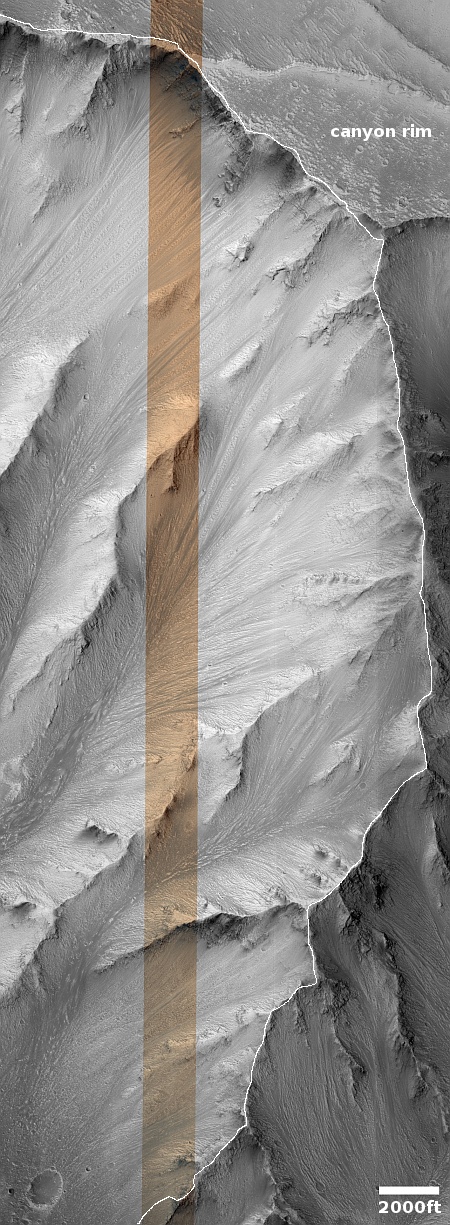
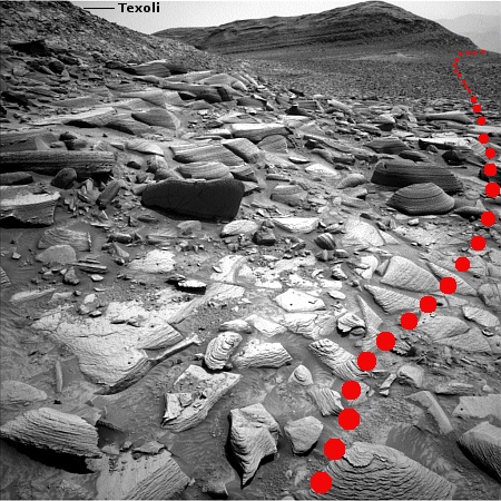
Cool image time! The picture to the right, cropped, reduced, and sharpened to post here, was taken on September 26, 2023 by the high resolution camera on Mars Reconnaissance Orbiter (MRO). It shows a field of scattered elongated dunes on a flat older surface with craters and what appear to be smaller ripple dunes (in the lower left). The large elongated dunes tend to be oriented in an east-west manner, while the older tiny ripple dunes appear to have a north-south orientation.

Very clearly the larger dunes appear to be traveling across that flat older surface, though whether there is any documented movement is unknown. Generally (though there are exceptions) scientists have found most of the dunes on Mars to be either inactive, or if they are moving because of the wind that movement is very tiny per year. In this case there is one dark spot on the dunes, near the center of the picture, where it appears a collapse might have occurred, suggesting recent change.

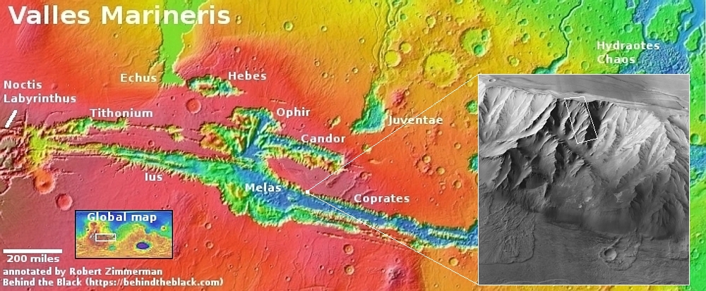
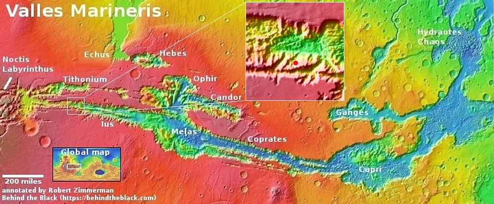
On the center right of the picture is the end point of a long ridgeline extending 10 to 12 miles to the east and rising about 7,300 feet, as shown in the overview map above. The small rectangle in the inset shows the area covered by the photograph.

At the base of that ridgeline can be seen a series of terraces descending to the west, suggesting that this hill might be volcanic in nature, with each terrace indicating a separate lava flow. The location is in the dry equatorial regions, so near-surface ice is likely not an explanation.

In the inset the mountain wall to the north is the large mountain chain that bisects this part of Valles Marineris. It overwhelms this small 7,300-foot-high ridge, rising more than 22,000 feet from these dunes with its high point still one or two thousand feet below the rim of Valles Marineris itself.

Once again, the grand scenery of Mars amazes. Imaging hiking a trail along that ridgeline, with the mountains rising far above you to the north and south.

First Juno images of Io from December 30th fly-by

Io as seen by Juno on December 30, 2023
For original global image go here. For original of inset go here.

The first raw Juno images taken of the Jupiter moon Io during its close fly-by on December 30, 2023, the closest in more than twenty years, have been released by the science team and citizen scientists have begun processing them.

The global picture to the right, rotated and reduced to post here, was processed by Kevin Gill. The inset of the volcanic mountains near the terminator was processed by Thomas Thomopoulos. As he notes, to obtain better detail he enhanced the colors and image and then zoomed in.

In the inset, note the northeast flows coming off the two mountains near the center. With the lower mountain, this flow appears to lie on top of a larger flow that extended out almost to the mountain to the right.

Io is a planet of continuous volcanic activity. For example, when the global image above was taken, the plume of a volcano eruption was visible on the right horizon, as shown in this version, its exposure adjusted by Ted Stryk. Catching such eruptions on Io is not unusual, considering its continuous volcanic activity generated by the tidal forces the planet undergoes from its orbit around Jupiter. In fact, the very first plume was imaged in 1979 by Voyager 1 during its short fly-by, and proved a hypothesis of such activity that scientists had only published one week earlier.

The ancientness of rocks on Mars

Ancient rocks on Mars
Click for original image.

Cool image time! The picture to the right, cropped, reduced, and enhanced to post here, was taken on December 27, 2023 by the high resolution camera on the Mars rover Curiosity. It shows what is a somewhat typical rock found on the ground as Curiosity climbs Mount Sharp in Gale Crater.

Two features stand out. First, the many layers illustrate again the cyclical nature of Martian geology. Many sedimentary events occurred over a long time to create this rock, each cycle putting down a new layer, with some intervening time periods possibly removing layers as well. Such layering has now become evident in both ground photos taken by rovers as well as orbital images.

Second, the delicate nature of some layers indicates the incredibly slow erosion process on Mars, enhanced by the red planet’s one-third gravity. The atmosphere is incredibly thin, less than 0.1% of Earth’s. Yet given time the wind had been able to wear away the edges of this rock. The thin atmosphere and light gravity has also allowed some material to remain in a delicate manner that would be impossible on Earth.

Thus, for these thin flakes to have formed has required a great deal of time. The very nature of this rock speaks of an ancient terrain, shaped slowly by inanimate processes with no active life around to disturb things.

Curiosity science team releases movies of Mars from dawn to dusk

Using its front and rear hazard avoidence cameras, the Curiosity science team had the rover take two full sets of images looking in one direction for twelve hours straight in order to create two movies of Mars that show an entire day, from dawn to dusk.

I have embedded both movies below. From the press release:

When NASA’s Curiosity Mars rover isn’t on the move, it works pretty well as a sundial, as seen in two black-and-white videos recorded on Nov. 8, the 4,002nd Martian day, or sol, of the mission. The rover captured its own shadow shifting across the surface of Mars using its black-and-white Hazard-Avoidance Cameras, or Hazcams.

Instructions to record the videos were part of the last set of commands beamed up to Curiosity just before the start of Mars solar conjunction, a period when the Sun is between Earth and Mars. Because plasma from the Sun can interfere with radio communications, missions hold off on sending commands to Mars spacecraft for several weeks during this time.

The first looks forward, into Gediz Vallis, where Curiosity will eventually travel. The second looks back down Mt Sharp and out across the rim of Gale Crater.
» Read more
Mapping the major lava flood events in Mars’ volcano country

The volcanic events in Mars' volcano country
Click for original map.

In a paper just released, scientists have used the orbital data from Mars Reconnaissance Orbiter (MRO) to map on Mars forty different past volcanic eruptions of extensive flood lava covering large regions, all within the region I dub “volcano country” because its entire surface seems mostly shaped by flows of lava.

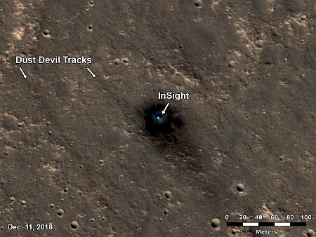
The map above, figure 1 from the paper, shows the study area (within the white rectangle), with its global context and additional information added by me on the right. Most of the largest earthquakes detected by InSight ran from north-to-south down the center of the white box. The named features are all large flood lava events, with the youngest being Athabasca. Within the Cerburus Plains feature the researchers mapped many smaller events which brought the total up to forty. From the abstract:

An area almost as large as Europe was investigated. The study revealed the products of more than 40 volcanic events, with one of the largest flows infilling Athabasca Valles with a volume of 4,000 km3. The surface appearance and material properties suggest that Elysium Planitia is composed of basalt, the most common type of lava on Earth. The area also experienced several large floods of water, and there is evidence that lava and water interacted in the past. However, while there could be ice in the ground today, it likely occurs in small patches.

None of these flood lava events involved the gigantic volcanoes that surround this region. Instead, the lava erupted from vents within this region, and then flowed downgrade to flood large areas, sometimes covering over parts of earlier lava floods. All also flowed much faster than lava on Earth, flooding vast regions — comparable to entire countries — often in mere weeks.

Juno’s closest image of Europa suggests recent surface activity

Juno's best image of Europa
Click for original image.

Analysis by scientists of the closest image of Europa taken during Juno’s close-fly on September 29, 2022 suggests that a particular strange feature, dubbed the “platypus” due to its shape, might be very young and indicate recent surface activity that could be related to underground liquid water.

That picture, reduced and sharpened to post here, is to the right. It is figure 2 of the paper. The description of this photo from the abstract:

Intricate networks of cross-cutting ridges and lineated bands surround an intriguing 37 km (east-west) by 67 km (north-south) chaos feature with a concentric fracture system, depressed matrix margins, and low-albedo materials potentially associated with brine infiltration. The morphology and local relief of the chaos feature are consistent with formation in the collapse of ice overlying a salt-rich lens of subsurface water. Low-albedo deposits, similar to features previously associated with hypothesized cryovolcanic plume activity, flank nearby ridges. The SRU’s high-resolution view of many types of features in a single image allows us to explore their regional context and greatly improve the geologic mapping of this part of Europa’s surface. The image reveals several relatively youthful features in a potentially dynamic region, providing baselines for candidate locations that future missions can investigate for present day surface activity.

SRU is Juno’s Stellar Reference Unit camera, designed to take pictures using only the low light of Jupiter reflected onto nighttime surfaces of Jupiter’s moons. It took this photo when Juno was only 256 miles above the surface.

This feature will obviously become a prime target for Europa Clipper when it arrives into orbit around Jupiter in April 2030. From this vantage point — safer than continuous exposure to Jupiter’s magnetosphere while in orbit around Europa — the spacecraft will do 44 close-flys of the moon.

Japan’s SLIM lunar lander releases its first pictures of Moon

Oblique view of Moon by SLIM
Oblique view of the Moon, as seen by SLIM.
Click for original image.

Japan’s space agency JAXA today released the first pictures taken of the Moon by its SLIM lunar lander after entering lunar orbit on December 25, 2023.

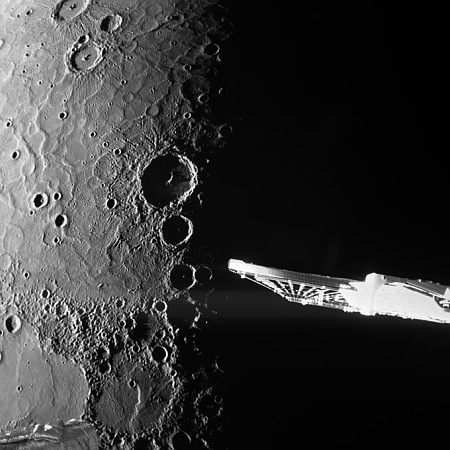
Three images were included in the tweet. The one to the right, reduced to post here, gives an oblique view of the Moon, including its horizon. None of the images are of great scientific value, but all are very significant in terms of SLIM’s engineering. They prove the spacecraft is operating as designed, able to orient itself precisely as well as point its camera correctly. These facts bode well for the precision landing attempt, which is SLIM’s main purpose, now targeting January 24, 2024. The primary goal is to demonstrate the ability for an unmanned spacecraft to land autonomously within a tiny landing zone only 300 feet across.

If SLIM succeeds, it will then hopefully operate for one lunar day, about two weeks. It is not expected to survive the lunar night that follows.

The uncertainty of science as proven by the Webb Space Telescope

A long detailed article was released today at Space.com, describing the many contradictions in the data coming back from the Webb Space Telescope that seriously challenge all the theories of cosmologists about the nature of the universe as well as its beginning in a single Big Bang.

The article is definitely worth reading, but be warned that it treats science as a certainty that should never have such contradictions, as illustrated first by its very headline: “After 2 years in space, the James Webb Space Telescope has broken cosmology. Can it be fixed?”

“Science” isn’t broken in the slightest. All Webb has done is provide new data that does not fit the theories. As physicist Richard Feynman once stated bluntly in teaching students the scientific method,

“It doesn’t make a difference how beautiful your guess is, it doesn’t make a difference how smart you are, who made the guess, or what his name is. If it disagrees with experiment, it’s wrong.”

Cosmologists for decades have been guessing in proposing their theories about the Big Bang, the expansion of the universe, and dark matter, based on only a tiny amount of data that had been obtained with enormous assumptions and uncertainties. It is therefore not surprising (nor was it ever surprising) that Webb has blown holes in their theories.

For example, the article spends a lot of time discussing the Hubble constant, describing how observations using different instruments (including Webb) have come up with two conflicting numbers for it — either 67 or 74 kilometers per second per megaparsec. No one can resolve this contradiction. No theory explains it.

To me the irony is that back in the 1990s, when Hubble made its first good measurements of the Hubble constant, these same scientists were certain then that the number Hubble came up with, around 90 kilometers per second per megaparsec, was now correct.

They didn’t really understand reality then, and they don’t yet understand it now.

What cosmologists must do is back away from their theories and recognize the vast areas of ignorance that exist. Once that is done, they might have a chance to resolve the conflict between the data obtained and the theories proposed, and come up with new theories that might work (with great emphasis on the word “might”). Complaining about the paradoxes will accomplish nothing.

Isolated mesa on Mars

An Isolated mesa on Mars
Click for original image.

Cool image time! The picture to the right, cropped, reduced, and sharpened to post here, was taken on August 13, 2023 by the high resolution camera on Mars Reconnaissance Orbiter (MRO).

The central butte is about 100 feet high. Not only are its flanks terraced, suggesting sedimentary layers, note the many black dots on its northern slopes. Those dots appear to be many boulders that appear to have rolled down the slopes to settle mostly near the mesa’s base.

The boxwork ridges to the west and south suggest the ground was fractured in some event to produce cracks, which were later filled with material that was erosion resistent. As the terrain was worn away by wind it left these ridges behind.

The prevailing winds in this region are believed to blow mostly to the south, which might explain the parallel ridges south of the mesa. Or not. On this I am guessing entirely.
» Read more

Update on Ingenuity

Overview mapClick for interactive map.

The overview map above shows the travels of both the rover Perseverance and the helicopter Ingenuity on Mars through today, with the blue dot marking Perseverance’s present location and the green dot Ingenuity’s. Because of image downloads today from Perseverance — including a few more pictures taken by the helicopter during several of its recent flights — the helicopter’s engineering team has finally been able to add the flight paths for flights #68, #69, and #70 to this map, as well as provide more accurate information about what each accomplished..

Flight #68, which took place on December 15, 2023, a few days later than originally planned, as I reported on December 20, 2023 when the first preliminary data arrived. At the time it appeared the flight had ended prematurely by almost 1,500 feet. We now know the flight did end early, but by not that much. Instead of flying, as per its flightplan, to the northeast 2,716 feet for 147 seconds and then returning to its take-off point, it flew out and back 2,304 feet for 131 seconds. The engineering team has not explained why it turned around prematurely by about 200 feet.

Flight #69 on December 20, 2023 was supposed fly 2,304 feet total over 131 seconds, also going out and back, traveling to the east-northeast. It ended up flying 2,315 feet over 135 seconds on a flight path that was almost identical to flight #68. Like most previous flights, it appears it hovered over its landing spot for a few extra seconds before descending in order to make sure it would land safely.

The final numbers for flight #70 have not yet been added to the flight log, but the engineering team has apparently been able to figure out the path the helicopter took and where it landed from the images that have been downloaded in the past few days. The flight plan had called for a relatively short flight, 849 feet long, but taking almost as long as the previous two, 129 seconds, thus allowing Ingenuity to get better and more detailed scouting pictures of the terrain below it for scientists to review.

One more detail: It appears that the Perseverance science team has decided to use Ingenuity data to guide its route. Rather than follow the planned course, as indicated by the red dotted line, the rover has been following the ground scouted by Ingenuity on its 63rd flight on October 19, 2023. This has taken Perseverance deeper into the rough fractured terrain to the south, where it likely can obtain better geological data.

It also suggests that Ingenuity’s more recent flight paths are giving us a hint as to Perseverance’s future travels.

Galaxies galore, near and far

Galaxies galore, and near and far

Cool image for the day after Christmas! The picture to the right, reduced and sharpened to post here, was taken by the Hubble Space Telescope, and shows a cluster of galaxies that all seem near each other. However, as the caption notes,

[W]hilst NGC 1356 [the largest spiral] and LEDA 95415 [close by its left] appear to be so close that they must surely be interacting, the former is about 550 million light-years from Earth and the latter is roughly 840 million light-years away, so there is nearly a whopping 300 million light-year separation between them. That also means that LEDA 95415 is likely nowhere near as [small] as it appears to be.

On the other hand, whilst NGC 1356 and IC 1947 [farthest to the left] seem to be separated by a relative gulf in this image, IC 1947 is only about 500 million light-years from Earth. The angular distance apparent between them in this image only works out to less than four hundred thousand light-years, so they are actually much much closer neighbours in three-dimensional space than NGC 1356 and LEDA 95415!

The two galaxies farthest apart in this image are actually close enough together to interact significantly. Though this picture doesn’t have the resolution to see it, there is likely a stream of stars between the two.

Note also the numerous tiny other galaxies scatterered throughout the picture. In fact, except for three stars (the objects with the north-south-east-west spikes), every object is a galaxy holding stars too numerous to count.

Japan & NASA negotiating plan to put Japanese astronaut on later Moon landing mission

According to the Japanese press, Japanese and American government officials are negotiating a plan to include a Japanese astronaut on one of the later Artemis Moon landing missions, presently hoping to fly in the late 2020s.

Japan has been negotiating with the United States, aiming for its first landing on the moon in the late 2020s. Tokyo and Washington will establish and sign an agreement on the activities of Japanese astronauts on the moon as early as next month, according to several government sources.

These stories are likely linked to the blather from Vice President Harris last week saying the U.S. will fly an international astronaut to the Moon before the end of the decade. At the time NASA officials would not confirm her statement, other than to say that NASA had agreed to fly European, Canadian, and Japanese astronauts to its Lunar Gateway station as part of its Artemis lunar program.

Several important details must be noted. First, the schedule for Artemis, as designed by NASA using SLS, Orion, Lunar Gateway, and Starship, is incredibly optimistic. The first manned mission is presently scheduled for 2025, but no one believes that date, including many at NASA. It will likely slip to 2026 or even 2027.

Second, the program is very fluid, and could undergo major changes with a new administration, especially because of the high cost of SLS. Once Starship/Superheavy is flying, at a cost expected to less than 1% of SLS, with an ability to fly frequently instead of once every two or three years, a new government might scrap the entire Artemis program as designed. A shift from SLS to Starship entirely might actually increase the number of astronauts going to the Moon, both from the U.S. and the entire Artemis Accords alliance.

Japan’s SLIM lunar lander enters orbit around Moon

SLIM's landing zone
Map showing SLIM landing zone on the Moon.
Click for interactive map.

After almost four months of orbital maneuvers since its launch on September 7, 2023, Japan’s SLIM lunar lander entered lunar orbit today, with a targeted landing date of January 20, 2024.

The landing site is indicated by the map to the right near Shioli Crater. SLIM is mostly an engineering test mission, with its primary goal to test an autonomous unmanned landing system capable of putting a lander down within a small target zone of less than 300 feet across. It has some science instruments on board, but any data obtained from them will be an added bonus, since the lander is only designed to operate for about two weeks, during the first lunar day. It is not expected to survive the two-week long lunar night to follow.

Because of launch delays for both of the American landers, Intuitive Machine’s Nova-C and Astrobotic’s Peregrine, SLIM will make its attempt first.

Curiosity takes a close-up of distant cliffs

Panorama on December 20, 2023
Panorama on December 20, 2023. Click for full image.

Close-up of a distant cliff
Click for original image.

Cool image time! The picture to the right, reduced and sharpened to post here, was taken on December 21, 2023 by the chemistry camera (ChemCam) on the rover Curiosity. Originally designed to take close-ups of rocks very nearby the rover, the science team over time discovered that they could also use this camera to get close-ups of very distant objects, providing them another way to study the geology in Gale Crater and on Mount Sharp.

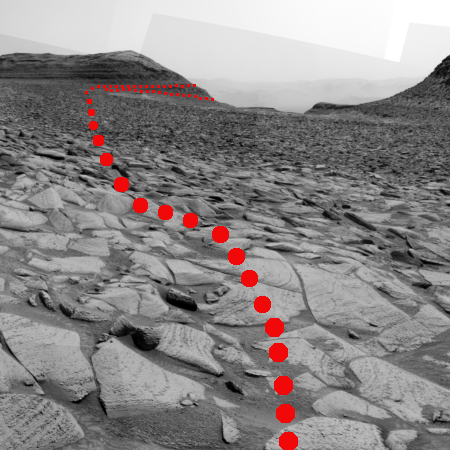
The picture to the right I think shows the horizon area indicated by the arrow on the panorama above, taken the day before. Note the many many layers, a geological feature that Curiosity has discovered is ubiquitous on Mars. Over eons the entire surface of the red planet has been layered repeatedly by cyclical geological events, producing layers within layers within layers. I guarantee that when Curiosity gets closer to this cliff it will see layers inside the smallest layers ChemCam can see now.

The red dotted line on the panorama above indicates the approximate planned route that Curiosity will eventually take, cutting across in front of that mountain and turning south somewhere near but to the west of where the cliff in this picture is located.
» Read more
Spectacular 2,300-year-old wall mosaic found in archaeological dig in Rome

Archaeologists have uncovered a 2,300-year-old wall mosaic in almost perfect condition in Rome that had been part of a banquet room overlooking a garden.

Estimated to be around 2,300 years old, the work is part of a larger aristocratic mansion, located near the Roman Forum, that has been under excavation since 2018. Almost five meters long (16.4 ft) and featuring depictions of vines, lotus leaves, tridents, trumpets, helmets and mythological marine creatures, the mosaic scene was painstakingly created using mother of pearl, shells, corals, shards of precious glass and flecks of marble. The piece is framed by polychrome crystals, spongy travertine, and exotic, ancient Egyptian blue tiles.

What makes this discovery “unmatched,” said archaeologist Alfonsina Russo, head of the Colosseum Archaeological Park in charge of the site, is not only the incredible conservation of the mosaic, but its decoration which also features celebratory scenes of naval and land battles likely funded — and won — by an extremely wealthy aristocratic patron who commemorated the victories on their walls.

Though it is believed such tiled mosaics were common in the homes of wealthy Roman aristocrats, most have not survived in good condition, making this discovery significant as well as beautiful. In addition, the location of the house and the details within the mosaic could make it possible to actually identify the Roman who lived here, which in itself would be a major historical find.

A glacial lake on Mars?

A glacial lake in a
Click for original image.

Cool image time! The picture to the right, rotated, cropped, reduced, and sharpened to post here, was taken on August 30, 2023 by the high resolution camera on Mars Reconnaissance Orbiter (MRO).

It shows what appears to be a glacial flow of ice, flowing downhill to the southwest and inside a wide canyon about three miles across. The canyon rims to the north and south are about 2,000 to 2,100 feet above the canyon’s lowest point, indicated by the string of “+” signs.

This close-up view immediately suggests a canyon whose glacier flows outward to the southwest into open lowland terrain, though the three craters, because they are undistorted, suggests that this flow is presently not active. That suggestion however would be wrong. It is always necessary to understand Martian geology to not only take close-in views at high resolution, but to zoom back and see the terrain in context.
» Read more

New Hubble image of Saturn

Saturn and its rings, as seen by Hubble

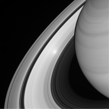
The annotated image above was taken by the Hubble Space Telescope on October 22, 2023, showing Saturn, its glorious rings, and several of its dozens of moons from a distance of about 850 million miles. For the unannotated version, go here. Of all the features, the spokes in the rings are the most intriguing.

Saturn’s spokes are transient features that rotate along with the rings. Their ghostly appearance only persists for two or three rotations around Saturn. During active periods, freshly-formed spokes continuously add to the pattern. In 1981, NASA’s Voyager 2 first photographed the ring spokes. Hubble continues observing Saturn annually as the spokes come and go. This cycle has been captured by Hubble’s Outer Planets Atmospheres Legacy (OPAL) program that began nearly a decade ago to annually monitor weather changes on all four gas-giant outer planets.

Hubble’s crisp images show that the frequency of spoke apparitions is seasonally driven, first appearing in OPAL data in 2021 but only on the morning (left) side of the rings. Long-term monitoring shows that both the number and contrast of the spokes vary with Saturn’s seasons. Saturn is tilted on its axis like Earth and has seasons lasting approximately seven years.

This year, these ephemeral structures appear on both sides of the planet simultaneously as they spin around the giant world. Although they look small compared with Saturn, their length and width can stretch longer than Earth’s diameter!

Though the origin of the spokes remains unsolved, the leading theory proposes they are caused by interactions between Saturn’s magnetic field and the seasonal changes in solar radiation.

Ingenuity’s engineers explain what they have learned flying the helicopter on Mars

Link here. The essay details carefully the problems they have faced, and how they have not only overcome them but used them to refine operations to squeeze far more capabilities out of the helicopter, beyond its initial design.

Saving flight time saves energy, reduces heating, and provides more freedom to use slower speeds to tiptoe around disruptive terrain that might otherwise endanger or significantly degrade the landing accuracy of the helicopter. Higher speeds and higher accelerations reduce the time needed to execute a given flight path. Higher altitudes permit higher speeds, as the wider field of view helps to keep ground features in view of Ingenuity’s navigation camera longer, counteracting the effect of increased speed. Expanding Ingenuity’s flight envelope had the potential to relax flight planning constraints and allow Ingenuity to operate more effectively alongside Perseverance.

As a result, beginning with flight 45 the team has made changes to increase flight speeds and acceleration at every point of every flight, thus allowing the helicopter to fly higher and farther with less strain.

This report however does not provide any information on Ingenuity’s last two flights, especially its 68th, which did not go as planned. The helicopter appears to be in good shape (the team has already planned the 69th flight, which was supposed to happen two days ago), but a more detailed update would be appreciated.

ULA’s Vulcan rocket fully stacked for the first time

Peregrine landing site
The landing site for Astrobotic’s Peregrine lunar lander

In preparation for its targeted January 8, 2024 launch, ULA’s Vulcan rocket has now been fully stacked for first time in its assembly building at Cape Canaveral.

ULA’s new rocket has rolled between its vertical hangar and the launch pad at Cape Canaveral Space Force Station several times for countdown rehearsals and fueling tests. But ULA only needed the Vulcan rocket’s first stage and upper stage to complete those tests. The addition of the payload shroud Wednesday marked the first time ULA has fully stacked a Vulcan rocket, standing some 202 feet (61.6 meters) tall, still surrounded by scaffolding and work platforms inside its assembly building.

It will next be rolled to the launchpad for some final checks prior to launch on January 8, 2023. Unlike most first launches, it carries a real payload, Astrobotic’s Peregrine lunar lander, which hopes to softly place several NASA and commercial payloads near the Gruithuisen Domes in the northwest quadrant of the Moon’s visible hemisphere, as shown on the map above.

1 16 17 18 19 20 271