It’s all a game!
In what can only be called a kabuki theater stunt, NASA today held a press conference and issued a press release promoting what is essentially the non-discovery of life on Mars by the science team operating the rover Perseverance.
Agency officials, led by acting NASA administrator Sean Duffy, proudly claimed the discovery justified the oft-stated goal of Perseverance, to find life on Mars.
“This finding by Perseverance, launched under President Trump in his first term, is the closest we have ever come to discovering life on Mars. The identification of a potential biosignature on the Red Planet is a groundbreaking discovery, and one that will advance our understanding of Mars,” said acting NASA Administrator Sean Duffy.
This is all garbage. First, Perseverance’s real objective has never been to find life on Mars. It is there to study the planet’s geology. If it should happen to detect a biosignature that would be great, but doing so has always been highly unlikely.
Second, the discovery that Duffy touts is itself quite underwhelming. The key quote from the press release that immediately precedes Duffy’s claim is very telling:
A potential biosignature is a substance or structure that might have a biological origin but requires more data or further study before a conclusion can be reached about the absence or presence of life.
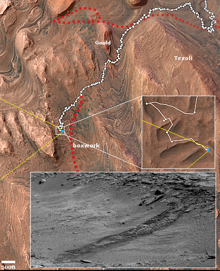
Furthermore, the biosignature that Duffy touts is actually not really a biosignature. They found “a distinct pattern of minerals” that might be sometimes be related to life processes, but not always.
The combination of these minerals, which appear to have formed by electron-transfer reactions between the sediment and organic matter, is a potential fingerprint for microbial life, which would use these reactions to produce energy for growth. The minerals also can be generated abiotically, or without the presence of life. [emphasis mine]
In other words, the data is very uncertain. It certainly doesn’t merit the loud push NASA and Duffy is giving it.
I suspect this push is the result of NASA’s fundamental lie about Perseverance’s so-called search for life, a lie that can never really be fulfilled. It is also related to hiding Perseverance’s limited capabilities. For example, Curiosity has a small lab allowing scientists to analyze samples in great detail. If Curiosity came across a real biosignature, it would be able to identify it.
Perseverance lacks this ability, because in its stead it has equipment for preserving core samples for later pick-up. All it really was designed to do was to gather those core samples. It can’t really do the same kind of ground analysis as Curiosity.