
New analysis strengthens evidence of water in lunar polar craters
The uncertainty of science: Scientists using data from India’s Chandrayaan-1lunar orbiter today claimed that they have confirmed water in the Moon’s polar craters.
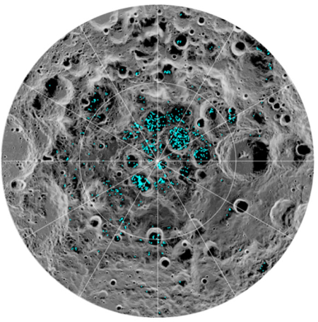
A team of scientists, led by Shuai Li of the University of Hawaii and Brown University and including Richard Elphic from NASA’s Ames Research Center in California’s Silicon Valley, used data from NASA’s Moon Mineralogy Mapper (M3) instrument to identify three specific signatures that definitively prove there is water ice at the surface of the Moon.
M3, aboard the Chandrayaan-1 spacecraft, launched in 2008 by the Indian Space Research Organization, was uniquely equipped to confirm the presence of solid ice on the Moon. It collected data that not only picked up the reflective properties we’d expect from ice, but was able to directly measure the distinctive way its molecules absorb infrared light, so it can differentiate between liquid water or vapor and solid ice.
Most of the newfound water ice lies in the shadows of craters near the poles, where the warmest temperatures never reach above minus 250 degrees Fahrenheit. Because of the very small tilt of the Moon’s rotation axis, sunlight never reaches these regions.
The image on the right shows the craters surrounding the south pole with water ice signatures, according to this new analysis.
This press release has some puzzling aspects. First, it is almost a decade since this data was gathered. Why is this suddenly reported now, just prior to the launch of Chandrayaan-2? I suspect this release has come out now to garner some PR for that new mission.
Also, there is nothing in this release that explains why these results should be considered more certain than previous results. In fact, previous data from different lunar orbits has been somewhat contradictory, suggesting a lot of uncertainty about the presence of water-ice at the lunar poles that this story does not address or alleviate in any way.
Nonetheless, this new analysis and data adds more weight to the possibility of water near the lunar poles, making that real estate a prime target for future bases. Too bad it is China that is aiming to grab this territory, while NASA wants us to circle the Moon in LOP-G, going nowhere.