
Numberphile – The Most Powerful Dice
An evening pause: Hat tip Edward Thelen, who adds, “Probability can be counterintuitive.”
An evening pause: Hat tip Edward Thelen, who adds, “Probability can be counterintuitive.”
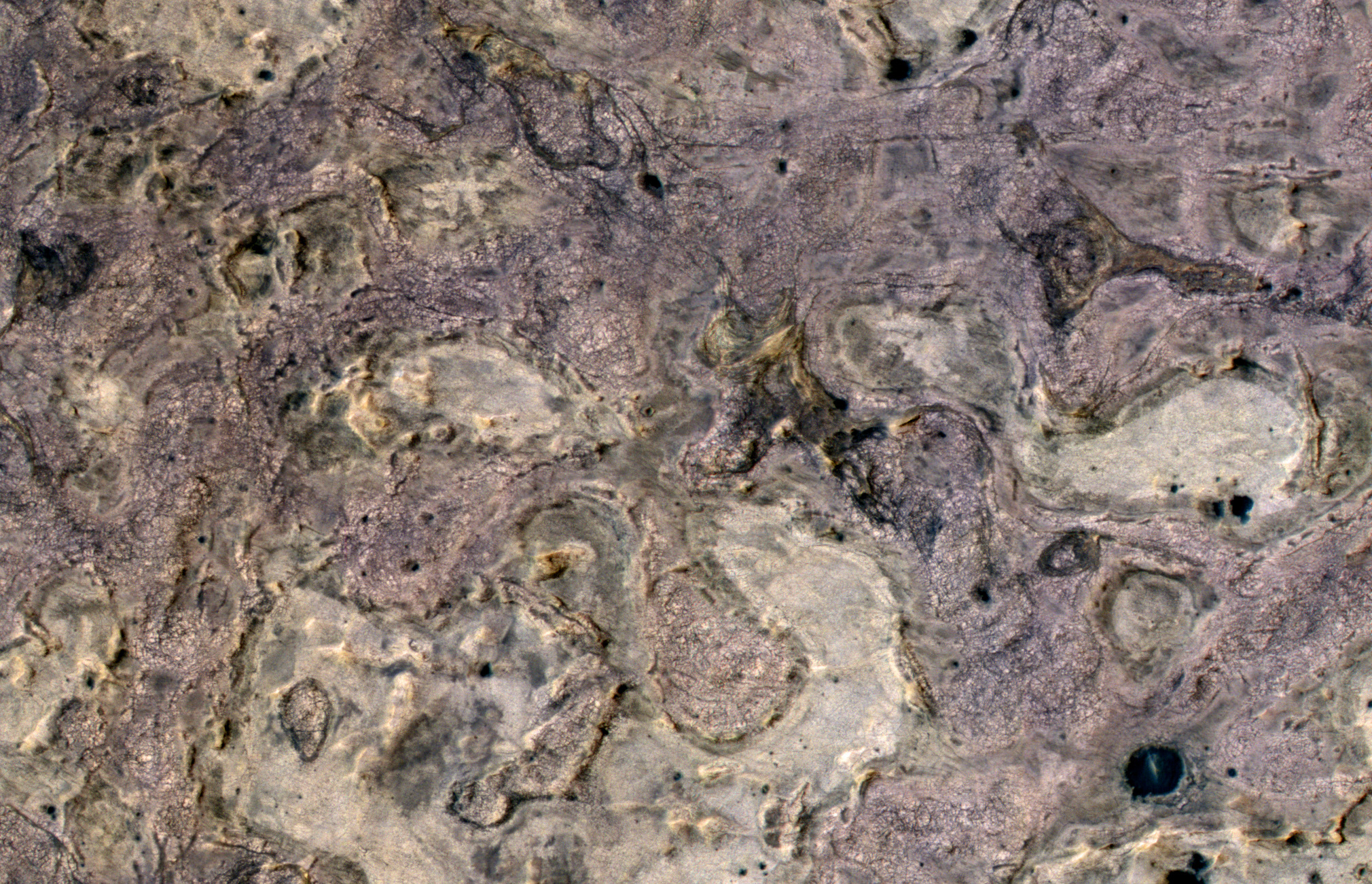
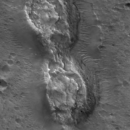
So what is it we are looking at in the image above? I have reduced the resolution slightly to fit it here, but you can see the full resolution image by clicking on the picture.
Is it a marble or granite kitchen counter? Nah, the surface is too rough.
Maybe it’s a modern abstract painting that we can find hanging in the Museum of Modern Art in New York. Nah, it has too much style and depth. Abstract art is much more shallow and empty of content.
Could it be a close-up of a just-opened container of berry-vanilla ice cream, the different flavors swirling and intertwined to enhance the eating experience? No, somehow it looks too gritty for ice cream.
» Read more
Using data gathered by the MESSENGER spacecraft while it was in orbit around Mercury, scientists now estimate that the planet’s crust is thinner than previously believed, 16 miles thick rather than 22 miles.
The crust is also as dense as aluminum. It is also the thinnest crust, relative to the planet’s core, of any rocky planet in the solar system.
Mercury’s core is believed to occupy 60 percent of the planet’s entire volume. For comparison, Earth’s core takes up roughly 15 percent of its volume. Why is Mercury’s core so large?
“Maybe it formed closer to a normal planet and maybe a lot of the crust and mantle got stripped away by giant impacts,” Sori said. “Another idea is that maybe, when you’re forming so close to the sun, the solar winds blow away a lot of the rock and you get a large core size very early on. There’s not an answer that everyone agrees to yet.”
There appears to be a great deal of uncertainty to these conclusions, and I would not be surprised if these conclusions change with the arrival of more data.
South Korea’s second largest earthquake has now been linked by two different studies to the injection of water deep below the surface at a new geothermal power plant.
Perched on South Korea’s southeast coast and far from grinding tectonic plates, Pohang is an unlikely spot for a big earthquake. Before the geothermal plant’s two wells were drilled, there had never been an earthquake there of any significance, says Kwanghee Kim, a seismologist at Pusan National University in Busan, South Korea, and lead author of one study. But while Kim was monitoring the aftermath of an unrelated earthquake in 2016, he began to detect rumbles from Pohang. That prompted his lab to deploy eight temporary seismic sensors at the site, which were finally in place on 10 November 2017. He expected any quakes to be small—after all, the largest previous quake tied to enhanced geothermal power, in Basel, Switzerland, was just 3.4 in magnitude.
It took only 5 days to be proved wrong. “The Pohang earthquake was larger than any predicted by existing theories,” Kim says. Although some initial measures placed the source of the quake several kilometers away from the plant, Kim’s network revealed that the earthquake, and several of its foreshocks, all began right below the 4-kilometer-deep well used to inject water into the subsurface to create the plant’s heating reservoir. Indeed, it appears likely that the well’s high-pressure water lubricated an unknown fault in the rock, causing it to slip and triggering the quake, Kim says.
A second paper, by European scientists who used regional seismic data, reinforces the South Korean team’s results, in particular its shallow depth. That study also points out that an earlier 3.1-magnitude earthquake also took place near the well bottom, increasing the odds of a common source. Satellite measures of shifts in the surface after the November 2017 quake support that idea, says Stefan Wiemer, the second study’s lead author and director of the Swiss Seismological Service in Zurich. It’s clear the locked fault was storing energy that was waiting to be released, Wiemer says. “If that fault would have gone next Tuesday or 50 years from now, we’ll never know.”
The article notes that scientists had previously concluded that injecting water underground for geothermal purposes was okay (since it reduced use of fossil fuels) while doing the same for fracking (to obtain and use fossil fuels) was bad.. The data here actually suggests just the reverse, since fracking has never produced an earthquake as large as the 5.5 magnitude Pohang quake.
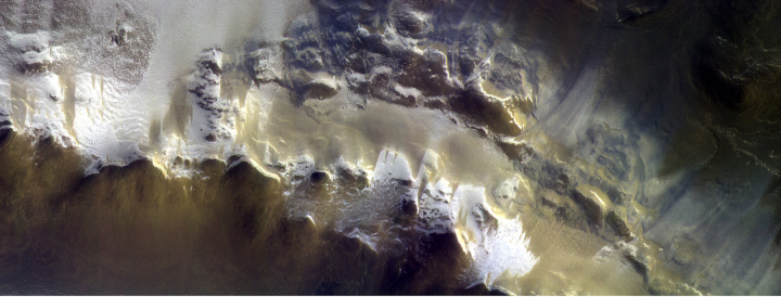
Europe’s Trace Gas Orbiter has released its first image after reaching its planned science orbit.
The image is posted above, reduced in resolution to show here. It shows a portion of the rim of Korolev Crater, a rare large crater located in the vast northern plains of Mars. Because it is so far north, it has ice on the rim which looks almost like glacial flows in this image.
The Trump administration is considering reinstating the fee system to purchase Landsat images that existed prior to 2008.
Not surprisingly, the Nature article is completely hostile to this idea. The quote below gives a flavor.
Since the USGS made the data freely available, the rate at which users download it has jumped 100-fold. The images have enabled groundbreaking studies of changes in forests, surface water, and cities, among other topics. Searching Google Scholar for “Landsat” turns up nearly 100,000 papers published since 2008.
A USGS survey of Landsat users released in 2013 found that the free distribution of Landsat imagery generates more than US$2 billion of economic benefit annually — dwarfing the programme’s current annual budget of roughly $80 million. More than half of the nearly 13,500 survey respondents were academics, and the majority lived outside the United States. [emphasis mine]
Why should scientists, a majority of which are not even Americans, have a free ride?
The science team for the space telescope Gaia, designed to map the positions of billions of stars, have released the probe’s second catalog, producing a 3D map of 1.7 billion stars in the Milky Way
The new data release, which covers the period between 25 July 2014 and 23 May 2016, pins down the positions of nearly 1.7 billion stars, and with a much greater precision. For some of the brightest stars in the survey, the level of precision equates to Earth-bound observers being able to spot a Euro coin lying on the surface of the Moon.
With these accurate measurements it is possible to separate the parallax of stars – an apparent shift on the sky caused by Earth’s yearly orbit around the Sun – from their true movements through the Galaxy. The new catalogue lists the parallax and velocity across the sky, or proper motion, for more than 1.3 billion stars. From the most accurate parallax measurements, about ten per cent of the total, astronomers can directly estimate distances to individual stars.
The catalog provides much more information than this. For example:
As well as positions, the data include brightness information of all surveyed stars and colour measurements of nearly all, plus information on how the brightness and colour of half a million variable stars change over time. It also contains the velocities along the line of sight of a subset of seven million stars, the surface temperatures of about a hundred million and the effect of interstellar dust on 87 million.
Gaia also observes objects in our Solar System: the second data release comprises the positions of more than 14 000 known asteroids, which allows precise determination of their orbits. A much larger asteroid sample will be compiled in Gaia’s future releases.
Further afield, Gaia closed in on the positions of half a million distant quasars, bright galaxies powered by the activity of the supermassive black holes at their cores. These sources are used to define a reference frame for the celestial coordinates of all objects in the Gaia catalogue, something that is routinely done in radio waves but now for the first time is also available at optical wavelengths.
I guarantee that many theories about specific strange stars, such as the plethora of different types of variable stars, are going to change drastically with this new and precise information. At the article they describe just one example relating to white dwarf stars.
Link here. The story details the new supercomputer simulation work attempting to model the internal processes inside a dying star that cause it to explode as a supernova.
For more than half a century, physicists have suspected that the heat produced by elusive particles called neutrinos, created in the core of a star, could generate a blast that radiates more energy in a single second than the Sun will in its lifetime. But they have had trouble proving that hypothesis. The detonation process is so complex — incorporating general relativity, fluid dynamics, nuclear and other physics — that computers have struggled to mimic the mechanism in silico. And that poses a problem. “If you can’t reproduce it,” Janka says, “that means you don’t understand it.”
Now, improvements in raw computing power, along with efforts to capture the stellar physics in acute detail, have enabled substantial progress. Janka’s simulation marked the first time that physicists had been able to get a realistic 3D model of the most common type of supernova to explode. Just months later, a competing group based at Oak Ridge National Laboratory in Tennessee repeated the feat with a heavier, more complex star. The field is now buzzing, with more than half a dozen teams currently working on exploding stars in 3D.
They have apparently solved one problem, figuring out how the neutrino blast wave gets enough energy to blast free from the star’s core. A close read of the article indicates that, while progress has been made, they still have many gaps of their understanding.
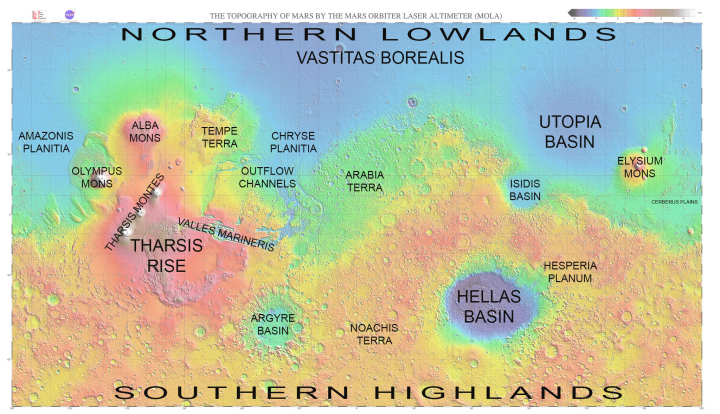
Let’s take a journey. Above is a global map of Mars, showing its largest and well known geological features. While far smaller than Earth, its lack of oceans means that Mars’ actual dry surface has about the same square footage as the continents of Earth. It is a vast place. Getting a close look at every spot is going to take many decades of work, and probably won’t be finished until humans are actually walking its surface.
Let’s pick a spot, zoom in and find out what’s there.
» Read more
Capitalism in space: SpaceX today successfully placed NASA’s new explanet space telescope, TESS, into orbit.
The first stage, which was making its first flight, successfully landed on the drone ship in the Atlantic. They hope to reuse this booster on a future Dragon launch.
Update: TESS’s solar arrays have successfully deployed.
The leaders in the 2018 launch standings:
11 China
8 SpaceX
4 ULA
3 Japan
3 Russia
3 Europe
3 India
The U.S. is now ahead of China, 12 to 11, in the national list.
Researchers have discovered nano-sized diamonds inside a recovered meteorite that suggest a formation process deep within a planet at least the size of Mercury.
The researchers used transmission electron microscopes to determine their composition and morphology, and found that the diamonds contained inclusions (impurities) made of chromite, phosphate and iron-nickel sulfides.
These inclusions are common in diamonds formed underground here on Earth, but this marks the first time they’ve been found in alien rocks. That’s interesting enough on its own, but it has much bigger implications – the team calculated that these diamonds could only have formed under pressure of more than 20 gigapascals. That means they must have been born inside a planet at least as big as Mercury, and possibly up to the size of Mars.
But there’s still more to the story. The fact these diamonds made it to Earth implies that their home planet, whatever it may have been, is no longer with us, since it would take quite a cataclysm to wrench them out of their birthplace deep underground and fling them into space. Instead, the team believes the diamonds came from a planetary embryo.
Not so fast. Though the researchers themselves, in the released paper, assume that the diamonds could only have formed from inside a now destroyed large planet, this leaves out the possibility that the diamonds formed inside one of the existing terrestrial planets, were moved upward toward the surface by later geological process (as happens to diamonds are here on Earth), and then were thrown from the planet by a later nearby impact. This scenario is just as likely.
Nonetheless, this discovery is fascinating. More than anything, it illustrates the inconceivable amount of time that has passed in creating our solar system. Any of these scenarios requires time, time in quantities that no human can really understand or conceptualize.
SpaceX today scrubbed the launch of NASA’s TESS space telescope, designed to look for transiting exoplanets orbiting the sky’s brightest stars.
The reasons for the scrub have not yet been announced, but the company says it is aiming for a new launch date on April 18.
Yesterday was another of my many cave adventures, but different than most. Instead of exploring and mapping newly discovered or out-of-the-way remote cave passages, I participated in a project of the Central Arizona Grotto (a chapter of the National Speleological Society and located in Phoenix) to remove years of graffiti from Peppersauce Cave. You can see pictures of yesterday’s effort here, published by the Arizona Star.
You won’t see any pictures of me. The younger cavers were far more photogenic.
Peppersauce has become what cavers call a “sacrificial cave.” It is open and ungated, relatively easy to traverse, and very well known throughout the state. Thus, many inexperienced people go there to see it, most of whom know little about caving, the ethics of protecting them, or the proper techniques for caving safely. Yesterday, while we were working to either sand-blast, chemically remove, or grind away old spray-paint (some of which was sadly obscene), I must have seen between 150 to 200 people go by. At least two thirds of them were not wearing helmets. Many clearly had never been in a cave before. Some were not wearing headlamps, carrying flashlights instead (which makes climbing harder because you don’t have use of both hands and can easily lose your light). A few even came in with no lights, depending instead on the lights their companions carried.
Because of this heavy traffic, Peppersauce has been badly trashed. On visits by experienced cavers we routinely carry out bags of trash, only to find that trash reappearing, sometime in mere hours. The walls of the cave had been covered with graffiti, some many layers deep.
Ray Keeler of Central Arizona Grotto (CAG) has organized several projects in the past to remove this graffitti over the past two decades. The effort he is leading this year is the third, and has the help of cavers from grottos throughout the state. This was the fourth clean-up weekend, and the first that I was able to attend (having missed the first three due to scheduling conflicts).
I’ve done similar things before, but never on this scale. It was quite educational using the solvent to remove some graffiti, but unfortunately many types of paint are completely resistant to removal by either sand-blasting or solvent. After awhile I got discouraged doing solvent work. Too often nothing got removed. In the afternoon I switched to our last technique, grinding, and was far more gratified with the results. The grinder, which we do not use on formations, removes only the slightest layer of material, and thus does little damage. It however is very effective in removing all paint, no matter how resistant.
The cave is now about two thirds cleaned. We are racing to finish the rest before the summer, because a typically insane reason forced upon us by the government. You see, according to a law passed by Congress, graffiti that is more than fifty years old is considered historical, and cannot be removed without a great deal of paperwork and complex bureaucracy. Spray paint was invented in the late 1960s (about fifty years ago), and so some of this ugly graffiti, no matter how obscene, is going to be protected by our government beginning later this year. Our goal is to get it removed beforehand, so that the cave can be returned to a more natural state, for future visitors to experience.
In linking to my sunspot update this week, there has been a lot of speculation at the climate website WattsUpWithThat that the next solar cycle has begun.
Our resident solar physicist, Dr. Leif Svalgaard commented and provided a link to something reported by his colleagues, something that likely would not have been possible without the fantastic solar observations of NASA’s Solar Dynamic Observeratory (SDO). He said: “Cycle 25 has already begun. It looks to me that SC25 will be a bit stronger than SC24, so probably no Grand Minimum this time.” It seems a small sunspot has been observed, that has the opposite polarity of cycle 24 sunspots. [emphasis in original]
The speculation at WattsUpWithThat, which suggested that this sunspot was the first such sunspot this cycle, was not quite accurate however. This sunspot with an opposite polarity, which decayed so quickly that it did not rate getting a sunspot number, was not the first. This week the Solar-Terrestrial Centre of Excellence, a Belgian organization focused on space-solar science, published this very good article discussing not only this sunspot but two others, one of which occurred more than a year ago.
» Read more
The coming dark age: The delaying tactics of the opponents to building the Thirty Meter Telescope in Hawaii has caused the consortium to announce that it now seriously considering moving the telescope to Spain’s Canary Islands.
These have been the most recent delaying tactics:
On Thursday, the Hawaii Senate approved a bill to ban new construction atop Mauna Kea, and included a series of audits and other requirements before the ban could be lifted. But House leaders said they don’t have plans to advance the bill. Democratic House Speaker Scott Saiki told the Honolulu Star-Advertiser that the “bill is dead on arrival in the House.”
There are also two appeals before the Hawaii Supreme Court. One challenges the sublease and land use permit issued by the Hawaii Board of Land and Natural Resources. The other has been brought by a Native Hawaiian man who says use of the land interferes with his right to exercise cultural practices and is thus entitled to a case hearing.
When the telescope gets moved, expect these barbarians in Hawaii to celebrate loudly, claiming their victory as a victory for “native rights.” What they will really be telling us is two things. First, they are against gaining new knowledge and new technology in a manner that does no one any harm. And two, they put racial rights above all, making them the worst sort of bigots.
Europe’s Mars Express orbiter has taken a high resolution image of Ismenia Patera, a very large crater located in the Arabia Terra region of Mars, the largest part of the transition zone between the low flat northern plains and the high rough southern terrain.
The crater is intriguing to scientists because they are not sure if it was created by an impact, or a volcano.
Certain properties of the surface features seen in Arabia Terra suggest a volcanic origin: for example, their irregular shapes, low topographic relief, their relatively uplifted rims and apparent lack of ejected material that would usually be present around an impact crater.
However, some of these features and irregular shapes could also be present in impact craters that have simply evolved and interacted with their environment in particular ways over time.
There is also additional evidence that this region was once home to volcanic activity. If so, that activity would have changed the terrain, and thus made its geological history more complex and difficult to decipher, a fact that is important since this is also a region that might have been at the edge of theorized northern Martian Ocean.
The Juno science team has released an animation that shows, in infrared and in three dimensions, the storms of Jupiter’s north pole.
The link has three videos. One shows the gas giant’s surprisingly irregular magnetic field, as found by Juno. The first and third show a low and a high fly-over of the north pole, in infrared. I have embedded both fly-overs below the fold. First watch the high fly-over, which is the first video. This will make the low fly-over more understandable as it flies over the eight smaller storms that encircle the pole’s central vortex.
» Read more
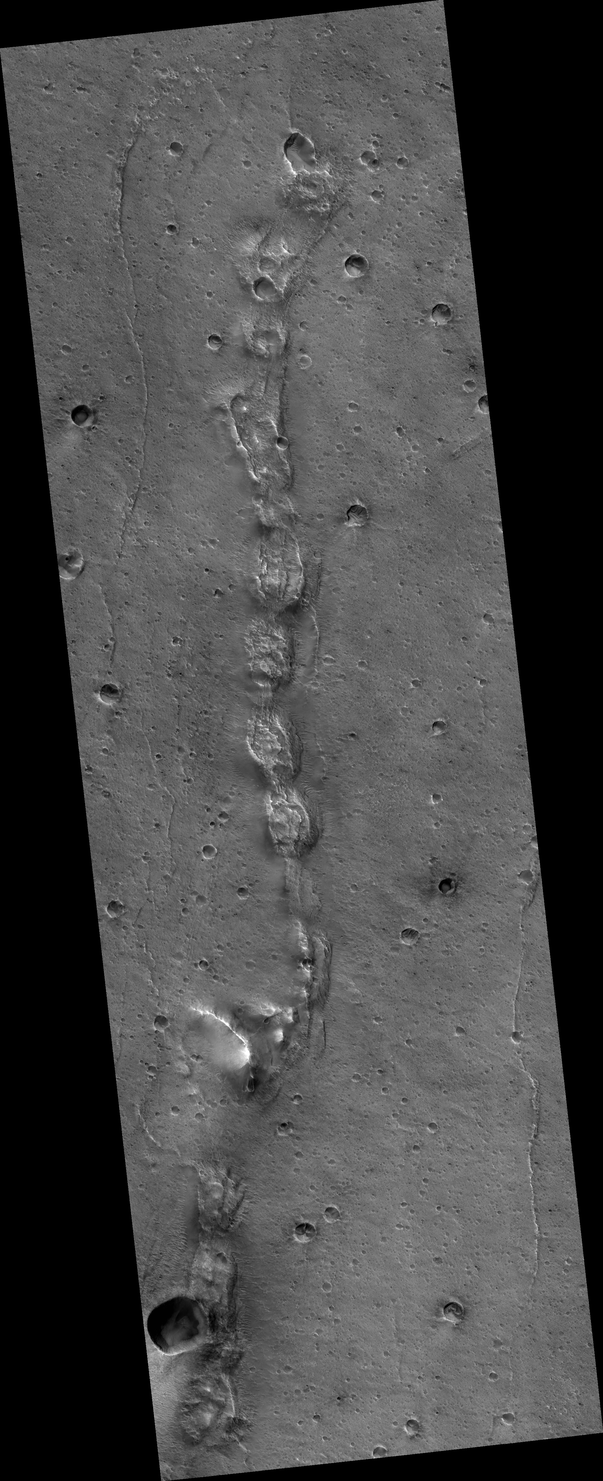
Time to once again delve into this month’s release of high resolution images from Mars Reconnaissance Orbiter. The image above, cropped, rotated, and reduced in resolution to post here, shows a string of strange mounds or hills, each with similar collapse features on their tops. If you click on the picture, you can see the full resolution image, rotated properly with north up. You can also go to the MRO post, which provides some additional information.
The white box indicates the location of the cropped close-up, at full resolution, to the right. This area is typical across the entire snake-like ridge. You have these mounds or hills, each with chaotic depressions at their tops. The depressions suggest that this ridge follows an underground void, like a lava tube. The ridge-like nature of the line of hills also suggest that this tube has been exposed by erosion over time, with the surrounding terrain more easily blown or washed away while the more resistant ridge remains.
At the same time, the line of hills is baffling. Why would a lava tube expand periodically to form something that looks like a string of pearls?
The location of this snaking ridge provides some additional context.
» Read more
As NASA prepares the Parker Solar Probe for its summer launch, engineers are reviewing an issue with the spacecraft’s thermometers.
As those preparations continue, officials are studying problems with devices known as platinum resistance thermometers that are part of the spacecraft’s thermal control system. Those devices have suffered a higher-than-expected failure rate, according to a presentation at an April 5 meeting of NASA’s Heliophysics Advisory Committee.
The thermometers are lightweight, highly sensitive temperature sensors used to help provide feedback to the spacecraft’s cooling system and solar arrays, NASA spokesman Dwayne Brown said April 9. “We put all spacecraft through a rigorous test program to make sure all systems are working as designed and it is normal for a test program to uncover issues.”
“The team is looking very carefully at whether any change is needed,” Peg Luce, acting director of NASA’s heliophysics division, said at the meeting. The issue, she said, was debated “quite significantly” at a review last week to approve the shipment of the spacecraft to Florida, including whether to delay that shipment to study the problem. “There are certain, possible fixes if we need to fix something that could be done at the Cape, so the decision was to go ahead and ship,” she said.
This issue is especially critical as the spacecraft is intended to fly as close as four million miles from the Sun. If these thermometers fail too easily, the spacecraft will not be able to monitor its temperature properly, and it will likely fail much sooner than planned.
After a year of aerobraking to lower its orbit, the European Space Agency’s Trace Gas Orbiter has reached its planned orbit around Mars, and is about to begin studying the red planet’s atmosphere.
The primary goal is to take a detailed inventory of trace gases – those that make up less than 1% of the total volume of the planet’s atmosphere. In particular, the orbiter will seek evidence of methane and other gases that could be signatures of active biological or geological activity.
On Earth, living organisms release much of the planet’s methane. It is also the main component of naturally occurring hydrocarbon gas reservoirs, and a contribution is also provided by volcanic and hydrothermal activity. Methane on Mars is expected to have a rather short lifetime – around 400 years – because it is broken down by ultraviolet light from the Sun. It also reacts with other species in the atmosphere, and is subject to mixing and dispersal by winds. That means, if it is detected today, it was likely created or released from an ancient reservoir relatively recently. Previous possible detections of methane by ESA’s Mars Express and more recently by NASA’s Curiosity rover have been hinted at, but are still the subject of much debate.
The Trace Gas Orbiter can detect and analyse methane and other trace gases even in extremely low concentrations, with an improved accuracy of three orders of magnitude over previous measurements. It will also be able to help distinguish between the different possible origins. [emphasis mine]
The highlighted sentence is important. Pinpointing a region where methane is concentrated will allow scientists to better understand where it is coming from, and what is causing its release. It could be microbiological life, but it also could be from active volcanic processes. Finding either or both would be significant, to put it mildly.