New analysis of Chandrayaan-1’s lunar orbital data might explain its detection of widespread surface hydrogen on the Moon

The Earth's magnetic field, shaped by the solar wind
The Earth’s magnetic field, shaped by the solar wind

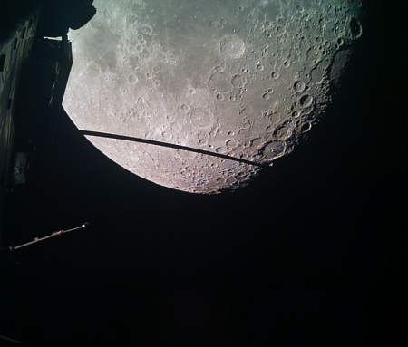
One of the significant finds coming from India’s first lunar orbiter, Chandrayaan-1, was the detection of hydrogen in many places across the entire lunar surface, in places where it seemed impossible for hydrogen to be there, even if it was locked in a molecule like water.

Researchers in Hawaii now think they have found an explanation by linking that data to the Earth’s long magnetotail, formed by the solar wind pushing against the Earth’s magnetic field. The graphic to the right illustrates that process. The scientists focused on the kind of weathering processes that occurred both when the Moon was inside that tail, and when it was not.

Li and co-authors analyzed the remote sensing data that were collected by the Moon Mineralogy Mapper instrument onboard India’s Chandrayaan 1 mission between 2008 and 2009. Specifically, they assessed the changes in water formation as the Moon traversed through Earth’s magnetotail, which includes the plasma sheet.

“To my surprise, the remote sensing observations showed that the water formation in Earth’s magnetotail is almost identical to the time when the Moon was outside of the Earth’s magnetotail,” said Li. “This indicates that, in the magnetotail, there may be additional formation processes or new sources of water not directly associated with the implantation of solar wind protons. In particular, radiation by high energy electrons exhibits similar effects as the solar wind protons.”

In other words, the evidence suggests that the hydrogen signal seen by Chandrayaan-1 might have been a very temporary implacement of that hydrogen by the solar wind, which ceases during the Moon’s periodic passages through the magnetotail. The Moon’s harsh environment then causes that hydrogen to vanish, only to reappear when it is once again exposed to the solar wind.

None of this is confirmed, so some skepticism is required. If true, however, it would provide further evidence that the hydrogen signal seen at the lunar poles that scientists hope is evidence of ice in the permanently shadowed craters might be nothing of the sort, and we shall find little ice there.

Polygons and scallops in the high mid-latitudes of the Martian lowland plains

Polygons and scallops in the high mid-latitudes of Mars
Click for original image.

Cool image time! Only yesterday I posted an image of polygons in the dry equatorial regions of Mars, where little evidence of near-surface ice is found and are thought to be the remnants from a long-dried lakebed.

Today we take a look at some polygons in the mid-latitudes of the icy northern lowland plains, where near-surface ice appears ubiquitous and as it sublimates away with the changing seasons causes all kinds of strange formations, including polygons.

The picture to the right, cropped, reduced, and sharpened to post here, is a good example, centered on a 0.6-mile-wide bright crater that appears to be filled with glacial ice. The image was taken on June 22, 2023 by the high resolution camera on Mars Reconnaissance Orbiter (MRO), and is located at 44 degrees north latitude on the western edge of Utopia Basin. As noted by the MRO science team in 2006 for a different MRO picture with similar features:
» Read more

Webb captures new infrared image of bi-polar jets shooting from baby star

HH 211 as seen by Webb
Click for original image.

Using the Webb Space Telescope, astronomers have taken a new infrared image of the baby star Herbig-Haro 211 (HH 211), known best for the bi-polar jets that shoot out in opposite directions at very great speeds.

That picture is to the right, reduced and sharpened to post here, and has about 5 to 10 times the resolution of previous infrared images.

The image showcases a series of bow shocks to the southeast (lower-left) and northwest (upper-right) as well as the narrow bipolar jet that powers them. …. The inner jet is seen to “wiggle” with mirror symmetry on either side of the central protostar. This is in agreement with observations on smaller scales and suggests that the protostar may in fact be an unresolved binary star.

Earlier observations of HH 211 with ground-based telescopes revealed giant bow shocks moving away from us (northwest) and moving towards us (southeast) and cavity-like structures in shocked hydrogen and carbon monoxide respectively, as well as a knotty and wiggling bipolar jet in silicon monoxide. Researchers have used Webb’s new observations to determine that the object’s outflow is relatively slow in comparison to more evolved protostars with similar types of outflows.

The team measured the velocities of the innermost outflow structures to be roughly 48-60 miles per second (80 to 100 kilometers per second). However, the difference in velocity between these sections of the outflow and the leading material they’re colliding with — the shock wave — is much smaller. The researchers concluded that outflows from the youngest stars, like that in the center of HH 211, are mostly made up of molecules, because the comparatively low shock wave velocities are not energetic enough to break the molecules apart into simpler atoms and ions.

The baby star at the center of these jets, about a 1,000 light years away, is estimated to be only a few ten thousand years old, and presently has a mass less than a tenth of the Sun. With time it will accrete more matter and become a full-sized star.

Moon’s south pole permanently shadowed regions are younger than expected

Map of Moon's south pole, with permanently shadowed regions indicated
Click for original image.

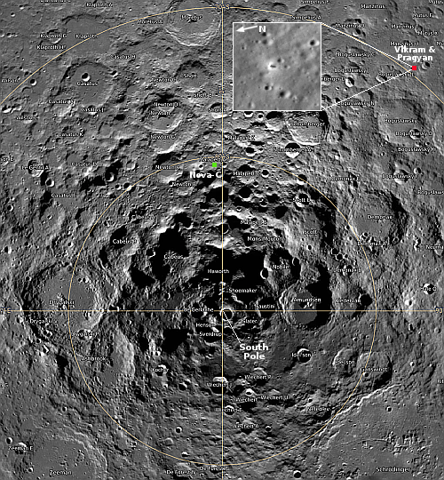
A new long range model of the Moon’s orbit and rotational tilt now suggests that the permanently shadowed regions (PSRs) in its south polar regions are much younger than previous predicted, which reduces the likely amount of ice that has been preserved there.

The map of the south pole region to the right, reduced, sharpened, and annotated to post here, shows the locations of those shadowed regions, with their predicted ages indicated by the colors (Gyr = billion years). Note that the Nova-C lander, planned for launch in mid-November, will land somewhat near some relatively young PSRs, as indicated by the red cross. From the press release:

“We calculated the lunar spin axis orientation and the extent of PSRs based on recent advances for the time evolution of the Earth-Moon distance,” he said. Early in its history, the Moon (which is 4.5 billion years old) was bombarded by comets and volcanism released water vapor from its interior, but continuously shadowed areas started to appear only 3.4 billion years ago. By that time these processes had started to die down, so most of the water that was delivered to the Moon or outgassed from its interior could not have been trapped in the polar regions. Any ice in the polar regions today must have a more recent origin.

“We have been able to quantify how young the lunar PSRs really are,” Schorghofer said. “The average age of PSRs is 1.8 billion years, at most. There are no ancient reservoirs of water ice on the Moon.”

Since other data suggests the presence of ice, it is possible that these reserves are regularly renewed by the arrival of impacts. It also suggests however that there might be less ice available than hoped. Above all, the red colored regions appear to be the most valuable real estate to explore first.

Note: The landing sites for both India’s Vikram lander and Russia’s Luna-25 lander were well beyond the map’s upper right edge, far outside the region where any permanently shadowed craters are located. The news outlets that talked about finding water or ice on either mission were simply illustrating their ignorance and sloppy reporting.

The drying out of Mars’ tropics

The drying out of Mars
Click for original image.

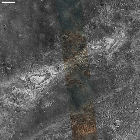
Cool image time! The picture to the right, cropped, reduced, and sharpened to post here, was taken on June 26, 2023 by the high resolution camera on Mars Reconnaissance Orbiter (MRO). The science team calls the features surrounding these small 20 to 60 foot high hills “polygon features,” an apt description and a geological feature that is seen in many places on Mars.

When these features are found in the icy higher latitudes, it is believed they are formed in connection to the freeze-thaw cycle that causes cracks in the near surface ice. When found in the dry equatorial regions, where these polygons are located, they are usually thought to be ancient evidence of past standing water that left behind these cracks, much like the cracks seen in mud after the water has evaporated away on Earth.

The formation of these tiny hills is a bit more complex.
» Read more

Chandra: New X-ray composite images of galaxies and supernovae remnants

Chandra image
Click for original image.

The science team for the Chandra X-Ray observatory today released five new composite images of two galaxies, two supernovae remnants, and the center of the Milky Way, combining data from multiple telescopes looking in radio, infrared, optical, and X-ray wavelengths.

The image to the right, reduced and sharpened to post here, is one of those pictures. From the press release:

As the galaxy moves through space at 1.5 million miles per hour, it leaves not one — but two — tails behind it. These tails trailing after ESO 137-001 are made of superheated gas that Chandra detects in X-rays (blue). ESO’s Very Large Telescope shows light from hydrogen atoms (red), which have been added to the image along with optical and infrared data from Hubble (orange and cyan).

The inset shows just the Hubble optical image, reduced by about 50%, to get a clearer sense of the galaxy itself. It appears to be a jelly-fish galaxy, flying through space at right angles to its plane and with tendrils of stars trailing off below.

The other four images are as interesting. The full set, including separate images in the individual wavelengths prior to combination, can be found here.

Astronomers discover two new polar-ring galaxies

Polar ring galaxy
Click for original image.

Using a combination of optical and radio telescopes as well as computer modeling, astronomers think they have identifed polar rings of gas orbiting two different galaxies, adding these to the relatively small population of known polar-ring galaxies.

Polar ring galaxies are unique in that they have an outer ring of gas and stars circling the galaxy at right angles to its plane. A composite image of one of these new galaxies is to the right, cropped, reduced and sharpened to post here. From the press release:

Jayanne English, a member of the WALLABY research team and also an expert in astronomy image-making at the University of Manitoba, developed the first images of these gaseous polar ring galaxies using a combination of optical and radio data from the different telescopes. First, optical and infrared data from the Subaru telescope in Hawaii provided the image for the spiral disk of the galaxy. Then, the gaseous ring was added based on data obtained from the WALLABY survey, an international project using CSIRO’s ASKAP radio telescope to detect atomic hydrogen emission from about half a million galaxies.

The creation of this and other astronomical images are all composite because they include information that our eyes can’t capture. In this particular case, the cold hydrogen gas component, invisible to the human eye, is seen in radio “light” using CSIRO’s ASKAP. The subtle colour gradient of this ring represents the orbital motions of the gas, with purple-ish tints at the bottom tracing gas that moves towards the viewer while the top portion moves away. The emission from the ring was separated from the radio emission emanating from the disk of the galaxy using virtual reality tools, in collaboration with Professor Tom Jarrett (University of Cape Town, South Africa).

As the abstract of the research paper notes, the computer models used “show that the data are consistent with PRGs [polar-ring galaxies] but do not definitively prove that the galaxies are PRGs.” There is much uncertainty, as it is difficult to determine the orientation of some rings relative to their galaxy’s plane.

Nonetheless, these result suggest polar ring galaxies might be more common, and thus might help refine the theories of galaxy formation and merger.

The orbits of the nearest stars orbiting the Milky Way’s central black hole are impossible to predict

The uncertainty of science: Using a computer program developed in 2018 that can predict with accuracy the orbits of more than three interacting objects, scientists have found that the orbits of the 27 nearest stars orbiting the Milky Way’s central black hole, Sagittarius A* (pronounced A-star) are impossible to predict after only a very short time.

“Already after 462 years, we cannot predict the orbits with confidence. That is astonishingly short,” says astronomer Simon Portegies Zwart (Leiden University, the Netherlands). He compares it to our solar system, which is no longer predictable with confidence after 12 million years. “So, the vicinity of the black hole is 30,000 times more chaotic than ours, and we didn’t expect that at all. Of course, the solar system is about 20,000 times smaller, contains millions of times less mass, and has only eight relatively light objects instead of 27 massive ones, but, if you had asked me beforehand, that shouldn’t have mattered so much.”

According to the researchers, the chaos emerges each time in roughly the same way. There are always two or three stars that approach each other closely. This causes a mutual pushing and pulling among the stars. This in turn leads to slightly different stellar orbits. The black hole around which those stars orbit is then slightly pushed away, which in turn is felt by all the stars. In this way, a small interaction between two stars affects all 27 stars in the central cluster. [emphasis mine]

To my mind, the quote by the scientist above should be considered the most absurd statement by a scientist ever spoken, except that nowadays scientists make such idiotic statements all the time. To think that such different conditions wouldn’t produce different results suggests a hubris that is astonishing for a person supposedly trained in the scientific method.

Regardless, these results suggest that acquiring an understanding of the dynamics that created these stars is going to be very difficult, if not impossible. The conditions change so rapidly, and in an unpredictable manner, that any theory proposed will be simply guessing.

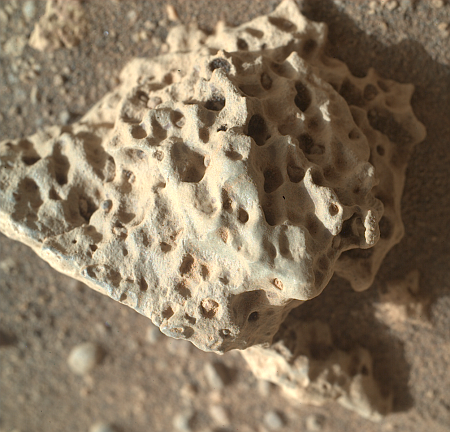
Weird rocks on Mars

Weird rocks seen by Curiosity and Perseverance
For original images, go here and here.

Time for two cool images, this time from both of the American rovers on Mars.

The left picture above was taken on September 9, 2023 by the high resolution mast camera on Curiosity. It shows what appears to be a many-layered but rounded rock which appears typical of the many boulders that cover the terrain through which Curiosity is presently traveling. In the past the layered rocks that Curiosity has observed lower on the flanks of Mount Sharp have not been rounded. Instead, the delicate layers have often extended outward at the rock’s edges, almost like paper or threads. For some reason, the layers in the rocks here have been eroded smooth, suggesting they were once covered by flowing water or ice, able to round the rough edges in a way that Mars’ thin atmosphere can’t.

What is puzzling is the location, higher on Mount Sharp. One would expect the reverse, with such erosion more typical lower on the mountain and uneroded delicate layers more common higher on the mountain.

The right picture above was taken on September 8, 2023 by one of the high resolution mast cameras on the rover Perseverance in Jezero Crater, about 5,000 miles to west of Curiosity. It shows a rock whose shape is so strange it is hard to fathom a geological process that would result in this form. Possibly the rock was a surface layer on a larger round boulder, and the normal freeze-thaw cycle of Mars caused it crack off as one piece. The lump in the middle however makes this explanation questionable.

Also puzzling is the curved shape. On Mars almost no geological layers have been found that are curved. They are generally flat and horizontal, reflecting the lack of tectonic processes that on Earth often twist and squash layers.

Repeating moonquakes on Moon found to be caused by remaining sections of Apollo 17’s LM

Scientists reviewing the archive seismic data produced by the seismometers placed on the Moon by the Apollo missions have discovered that repeating small moonquakes in that data were actually caused by base of Apollo 17’s Lunar Module (LM) that provided a launchpad for the part of the LM that lifted the astronauts off the Moon.

Triangulating the origin of the mystery quakes, researchers surprisingly realized they came from the Apollo 17 lunar lander base, which expands and vibrates each morning as it becomes heated by the sun.

“Every lunar morning when the sun hits the lander, it starts popping off,” Allen Husker, a Caltech research professor of geophysics who worked on the project, said in a statement. “Every five to six minutes another one, over a period of five to seven Earth hours. They were incredibly regular and repeating.”

That the extreme range of temperatures experienced by the LM could cause detectable quakes as the LM base expanded suggests strongly how difficult it is for a spacecraft to survive the lunar night lasting 14 Earth days. For all we know, that base has now literally fallen apart due to these stresses. This in turn suggests it is highly unlikely that India’s Pragyan rover will come back to life when the sun rises on September 22, 2023.

Lucy gets first images of its first target asteroid, Dinkinesh

The asteroid Dinkinesh as seen by Lucy

The asteroid probe Lucy has obtained its first images of Dinkinesh, the first of the ten asteroids the spacecraft is hoping to visit during its twelve year voyage to the Trojan asteroids.

The image to the left shows the motion of that asteroid over a two day period when Lucy was getting the pictures.

Lucy took these images while it was 14 million miles (23 million km) away from the asteroid, which is only about a half-mile wide (1 km). Over the next two months, Lucy will continue toward Dinkinesh until its closest approach of 265 miles (425 km) on Nov. 1, 2023. The Lucy team will use this encounter as an opportunity to test out spacecraft systems and procedures, focusing on the spacecraft’s terminal tracking system, designed to keep the asteroid within the instruments’ fields of view as the spacecraft flies by at 10,000 mph (4.5 km/s). Lucy will continue to image the asteroid over the next months as part of its optical navigation program, which uses the asteroid’s apparent position against the star background to determine the relative position of Lucy and Dinkinesh to ensure an accurate flyby. Dinkinesh will remain an unresolved point of light during the long approach and won’t start to show surface detail until the day of the encounter.

Lucy’s primary targets are asteroids in the two Trojan groups that orbit the Sun in the two Lagrange points in same orbit as Jupiter, fore and aft of the gas giant by 60 degrees. For a map of Lucy’s full mission profile, go here.

Frank Rubio on ISS sets new record for an American in space

Though Frank Rubio was only supposed to do a six month mission, a leak on the Soyuz capsule that brought him and his two crewmates into space has resulted in all three doing a mission exceeding one year, and setting a new record for an American in space.

Today Rubio broke the old American record of 355 days, set by Mark Vande Hei in 2022. When they return on September 27, 2023, all three will have spent 371 days in space, the third longest manned mission in history, exceeded only by Sergei Avdeyev’s 381 in 1999 and Valeri Polyakov’s 437 in 1994-1995, both on Russia’s Mir space station.

Based on my interviews with Polyakov and Musa Manarov (who was on the first mission with Vladimir Titov to spend one year in space — 366 days total — in 1988) for my book Leaving Earth, it will take Rubio about one year to fully recover from this mission, though he will likely be able to function almost normally within a month or so.

It remains interesting that these American records set by Rubio and Vande Hei occurred because of decisions by the Russians, not the American space agency NASA. NASA has consistently resisted doing long missions on ISS, even though this is exactly the kind of medical research required if we are to send humans on multi-year missions to Mars and beyond. Even more embarrassing, the longest NASA planned mission, flying Scott Kelly for 340 days, was touted by NASA as a year-long mission, even though it was never going to and did not achieve that distinction.

In doing this research the Russians have always led, and appear to continue to do so on ISS.

Ridge in Martian lowland plains

Tiny ridge in Martian lowlands
Click for original image.

Today’s cool image is interesting not because it shows us some spectacular Martian terrain, but because the most distinct feature is a thin ridge only a few feet high that pokes up out of the northern lowland plains for apparently no reason.

The picture to the right, cropped, reduced, and sharpened to post here, was taken on July 1, 2023 by the high resolution camera on Mars Reconnaissance Orbiter (MRO). The ridge is about 1.8 miles long, and is only about five feet high on its western end, rising to about 25 feet on its eastern end.

The colors differences indicate that the ridge’s peak is likely bedrock, and the surrounding greenish/blue hue suggesting sand and rocks covered with dust. The ridge might be the top of a deeper buried topological feature but that is only a guess.
» Read more

A galactic cloud

A galactic cloud
Click for original image.

Cool image time! The picture to the right, cropped, reduced, and sharpened to post here, was taken by the Hubble Space Telescope. It shows what scientists dub a lenticular galaxy, with features that put it somewhere between a spiral galaxy and an elliptical (which has no structure a appears instead a cloud of stars), sitting about 73 million light years away.

NGC 3156 has been studied in many ways … from its cohort of globular clusters, to its relatively recent star formation, to the stars that are being destroyed by the supermassive black hole at its centre.

Why this galaxy has no spiral arms is somehow related to its age and its central black hole, but the detailed theories that astronomers have to explain this are far from confirmed.

The image is interesting also because of its lack of foreground stars or background galaxies. Its location in the sky explains this, as Hubble was looking at right angle to the Milky Way’s galactic plane, essentially looking directly into the vast emptiness between the galaxies.

Curiosity’s upcoming travels on Mount Sharp

Curiosity's view on September 6, 2023
Click for original image.

Overview map
Click for interactive map.

The panorama above, cropped, reduced, sharpened, and annotated to post here, was created on September 6, 2023 from eleven pictures taken by the right navigation camera on the Mars rover Curiosity.

This mosaic looks south, into the slot canyon dubbed Gediz Valles. The red dotted line on the panorama as well as the overview map to the right indicates the planned route the science team plans on traveling as it sends Curiosity higher and higher on Mount Sharp. On the overview map Curiosity’s present position is indicated by the blue dot. The yellow lines show the approximate area covered by the panorama above.

As noted in today’s update from the science team:

The rover is currently driving across bumpy terrain consisting of rounded bedrock sticking up between dark sand and drift as she drives south, and slightly uphill, along the Mt. Sharp Ascent Route. Due to the rugged ground, the rover sometimes ends her drive with a wheel or two perched on a rock.

When the rover’s placement prevents use of the arm, the scientists have it do other things, such as take more images of the many layers on Kukenan.

As rocky as this future route is, it appears it is less rocky than earlier terrain, which the science team found impossible to traverse requiring several route detours. Thus, the pace forward has been a bit faster lately.

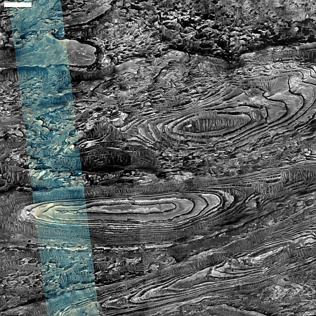
Layered glaciers in two small Martian craters

Layered glaciers in two small Martian craters
Click for original image.

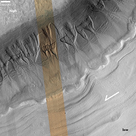
Cool image time! The picture to the right, cropped, reduced, and sharpened to post here, was taken on April 7, 2023 by the high resolution camera on Mars Reconnaissance Orbiter (MRO). It shows what planetary scientists label somewhat vaguely as “layered deposits,” because though the features inside both of these craters strongly resemble glacial ice features, until this is confirmed a good scientist remains skeptical.

I can be more bold, and call the layers glacial in both of these small and very shallow craters (less than a 100 feet deep). To explain this it is important to understand that the lighting and shadows make it hard to distinguish the high points of these layers. Based on the elevation data from MRO, the ground descends to the south, and the mesa in the southern half of each crater’s floor is actually far below the layers and material to the north.

This elevation data suggests that the layered material is surviving best against the crater’s northern interior wall, which at this latitude, about 36 degrees south, will be in shadow the most.
» Read more

Ingenuity flies on, completing its 57th flight

Overview map
Click for interactive map

On September 3, 2023 Ingenuity successfully completed its 57th flight on Mars, traveling 713 feet for two minutes and nine seconds. As noted at the tweet at the link, the helicopter has now accumulated more than 100 minutes of flight time.

As it has on almost all its recent flights, the helicopter flew a slightly longer distance for slightly longer that its flight plan, probably because it was taking time to find a safe landing spot.

The green dot on the overview map above shows Ingenuity’s new location. It has moved west and north of Perseverance, following the rover’s planned route as indicated by the red dotted line. The blue dot marks Perseverance’s present location. The yellow lines indicate the approximate area of the mosaic below, just released by the Perseverance science team, taken on July 8, 2023 by the rover’s high resolution camera and cropped and reduced to post here. It shows us the rover’s eventual path forward, into that mountain gap.

Mosaic looking west at the rim of Jezero Crater
Click for original, full resolution image (a large file).

Japan successfully launches XRISM X-ray space telescope and SLIM lunar lander

SLIM's landing zone
Map showing SLIM landing zone on the Moon.
Click for interactive map.

Japan today (September 7th in Japan) successfully used its H-2A rocket to place both the XRISM X-ray space telescope and SLIM lunar lander into orbit.

As of posting XRISM has been successfully deployed. SLIM has not, as it needs to wait until after a second burn of the rocket’s upper stage about 40 minutes later. The map to the right shows SLIM’s landing target on the Moon, where it will attempt a precision landing within a zone about 300 feet across.

This was Japan’s second launch this year, so it does not get included in the leader board for the 2023 launch race:

62 SpaceX
39 China
12 Russia
7 Rocket Lab
7 India

In the national rankings, American private enterprise still leads China in successful launches 71 to 39. It also still leads the entire world combined, 71 to 64, while SpaceX by itself now trails the rest of the world (excluding American companies) only 62 to 64.

Martian ice islands amidst a Martian ice ocean

Glacier country on Mars

Martian ice islands in a Martian sea of ice
Click for original image.

Cool image time! The picture to the right, cropped, reduced, and sharpened to post here, was taken on June 19, 2023 by the high resolution camera on Mars Reconnaissance Orbiter (MRO).

The scientists simply labeled this “Deposit Layers,” but that description hardly covers the incredibly diverse and puzzling features within the picture. We see layers, swirls, and radiating groves, all suggesting glacial features. We see mesas apparently covered with ice, and a flat surrounding lower plain that appears to be also ice but acting more like an ocean or sea. If there is any visible bedrock at this location it is difficult to determine.

The dominance of ice features is not surprising however, considering the location. The red dot on the overview map above marks this location, in a large 80-by-56-mile-wide basin inside the 2,000-mile-long northern mid-latitude strip I dub glacier country, because almost every image from MRO shows distinct glacial features. This particular basin is considered part of the segmented and indistinct canyon dubbed Mamers Valles, that winds its way through this glacier country of chaos terrain to eventually drain into the northern lowland plains.

From a geologist’s perspective, however, the layers are the most significant feature in the picture, as those layers mark the innumerable climate cycles that have apparently shaped the Martian surface. Mapping those layers will likely involve decades of work, but when largely completed we shall have a very precise history of the red planet’s geological history, going back several billion years.

LRO takes image of Vikram on Moon


Click for interactive map. To see the original
image, go here.

The science team for Lunar Reconnaissance Orbiter (LRO) yesterday released an oblique image taken of India’s Vikram lander, on August 27, 2023, four days after the lander touched down about 370 miles from the south pole.

The LROC (short for LRO Camera) acquired an oblique view (42-degree slew angle) of the lander. … The bright halo around the vehicle resulted from the rocket plume interacting with the fine-grained regolith (soil).

That image is shown in the inset to the right. I have cropped it to focus on Vikram itself, which is in the center of the inset, with its shadow to its right, the opposite of all the surrounding craters. Pragyan is in this image, but neither it nor its tracks appear visible. The rover had moved west from the lander, which would be downward to the line of three craters near the bottom of the inset. To get a better sense of Pragyan route, compare this image with the map India’s space agency ISRO released on September 2nd.

Martian mounds surrounded by moats

Martian mounds with moats
Click for original image.

Cool image time! The picture to the right, cropped, reduced, and sharpened to post here, was taken on February 1, 2023 by the high resolution camera on Mars Reconnaissance Orbiter (MRO). It shows what the camera team labels “Circular Mounds Surrounded by Moats,” which when all the known data is considered are probably caused by a spray of small meteorites landing on a field of ice.

Why ice? The location is at 37 degrees south latitude, in the cratered southern highlands of Mars, where many images show glacial-type features inside many craters. In fact, all the nearby craters at this location appear to have such features, suggesting the presence of near-surface ice trapped in these craters.

The picture actually looks at the floor of another such crater, with the mounds in the image’s upper left the crater’s indistinct central peaks. Though only 8.5 miles wide, the crater is deep, with interior walls that quickly rise 2,800 feet to the rim. That depth further suggests ice, as any snow that fell here in the far past could easily become trapped, inside what could be thought of a cold trap.
» Read more

The New York Times suddenly allows two scientists to admit the Big Bang theory might be wrong

Modern science
Modern science

The refusal by many in the scientific community to deny there is any uncertainty of science has been best illustrated for decades by the cosmologists who have put together the framework of the standard model for the creation of the universe, centered on the Big Bang, and their pitchmen in the mainstream press. Since the 1960s any skepticism of this model was generally treated as equivalent to believing in UFO’s, aliens, and the Face on Mars.

Thus, astronomers and astrophysicists did what necessary to protect their careers. Even if they had great doubts about the standard model and the Big Bang, they generally kept their mouths shut, saying nothing. Meanwhile, our increasingly corrupt press pushed this one explanation for the formation of the universe, treating the cosmologists who pushed it as Gods whose every word was equivalent of an oracle that must never be questioned.

This past weekend the New York Times suddenly admitted to the uncertainty surrounding the Big Bang, and for possibly the first time in decades allowed two scientists to write an op-ed that carefully outlined the problems with the standard model and the Big Bang theory, problems that have existed and been growing since the 1990s but have been poo-pooed as inconsequential and easily solved. Data from the Webb Space Telescope however has made that poo-pooing more and more difficult, as astrophysicists Adam Frank and Marcelo Gleiser make clear:
» Read more

Bubbling but frozen terrain on Mars

Bubbling but frozen terrain on Mars
Click for original image.

Cool image time! The picture to the right, cropped, reduced, and sharpened to post here, was taken on June 8, 2023 by the high resolution camera on Mars Reconnaissance Orbiter (MRO). It shows some of the more unusual terrain found at the higher latitudes in the Martian northern lowland plains.

How do we explain this strange landscape? Based on what little we presently know about Mars, at 40 degrees north latitude this bubbly-looking surface probably indicates the presence of a lot of near-surface ice that at some time in the past was heated for some reason and thus bubbled upward to form these mounds. Think of tomato soup simmering.

Unlike simmering tomato soup, this terrain is solid and no longer bubbling. We are looking at a soup that has frozen even as it bubbled. The process could have been like an ice volcano, the ice turning to thick slurry that froze quickly, like lava. Or it could have happened fast, and then froze to remain unchanging in the eons since.
» Read more

A triangular spiral galaxy

A triangular spiral galaxy
Click for original image.

Cool image time! The picture to the right, cropped, reduced, and sharpened to post here, was taken by the Hubble Space Telescope as part of a follow-up observations of a supernova that occurred in this galaxy in 2015. The galaxy, dubbed IC 1776, is about 150 million light years away.

Hubble investigated the aftermath of the supernova SN 2015ap during two different observing programmes, both designed to comb through the debris left by supernovae explosions in order to better understand these energetic events. A variety of telescopes automatically follow up the detection of supernovae to obtain early measurements of these events’ brightnesses and spectra. Complementing these measurements with later observations which reveal the lingering energy of supernovae can shed light on the systems which gave rise to these cosmic cataclysms in the first place.

As the caption notes, the spiral arms of this galaxy “are difficult to distinguish.” At first glance the galaxy instead appears triangular in shape, an impression that dissolves with a closer look.

JAXA schedules last H-2A rocket launch, carrying X-Ray telescope and lunar lander

SLIM's landing zone
Map showing SLIM landing zone on the Moon.
Click for interactive map.

Japan’s space agency JAXA today announced that it has finally rescheduled the launch of its XRISM X-Ray telescope and its SLIM lunar lander launch for September 7, 2023, lifting off using the last flight of its H-2A rocket.

The previous launch attempt several weeks ago was scrubbed due to high winds. This new launch date has a window of seven days, which means if weather scrubs the September 7th launch they will be able to try again immediately within that window.

The white dot on the map to the right shows the targeted landing site of SLIM, which is testing the ability of an unmanned probe to land precisely within a tiny zone of less than 300 feet across.

Meanwhile, with the retirement of the H-2A rocket and its replacement having not yet flown successfully (its first launch failed in March), Japan after this launch will be in the same boat as Europe, without a large rocket and lacking the ability to put large payloads into orbit.

Engineers had Vikram do short flight hop prior to shutting down

Indian engineers revealed today that prior to putting the Vikram lander to sleep for the long lunar night, they had the lander use its rocket engines to do a short up and down flight. From the first link:

“On command it (Vikram lander) fired the engines, elevated itself by about 40 cm as expected and landed safely at a distance of 30 to 40 cm away,” ISRO said in an update on ‘X’.

Before doing the hop engineers stored Vikram’s instruments and rover ramp, then redeployed them afterward to gather a tiny bit of new data before putting everything into hibernation.

The hop test proved that Vikram’s engines could be restarted even after being on the Moon for almost two weeks, and thus could potentially be used on a future sample return mission. It also suggested a future mission could choose to change its landing site periodically by use of its landing engines.

Engineers place Pragyan into sleep mode

With lunar sunset looming, engineers have completed all work on both the lander Vikram and the rover Pragyan and have prepared Pragyan as best as possible to survive the long 14-Earth-day long lunar night.

Currently, the battery is fully charged. The solar panel is oriented to receive the light at the next sunrise expected on September 22, 2023. The receiver is kept on.

All data from Vikram’s instruments has been transmitted back to Earth, through the rover. It appears that the mission has been using the rover has the main communications relay, not the lander. It also appears there is no expectation of the lander surviving the lunar night.

The sunspot count in August demonstrates fully the utter uncertainty of science

In doing these sunspot updates every month since I started Behind the Black thirteen years ago, one of the repeated common themes has been noting how little we really know about the basic fundamental processes within the Sun. We know the process involves nuclear fusion combined with fission, and that process also creates a powerful magnetic field that every eleven years flips in its polarity. We also know that this eleven year cycle corresponds to an eleven year cycle of rising and then falling sunspot activity.

The devil however is in the details, and we know very little about those details. How those larger processes link to the specific changing features on the Sun remains little understood, if at all. The sudden and entirely unexpected steep drop in sunspot activity in August, as noted in the release yesterday of NOAA’s monthly update of its graph that tracks the number of sunspots on the Sun’s Earth-facing hemisphere, demonstrates this level of ignorance quite starkly.
» Read more

India successfully launches its first solar observation satellite

India’s space agency ISRO tonight (September 2, 2023 in India) successfully used its PSLV rocket with six strap-on boosters to place in orbit its first solar observation satellite, Aditya-L1, lifting off from its coastal Sriharikota spaceport.

The spacecraft will eventually maneuver itself to the L1 point about one million miles closer to the Sun, where it will make continuous observations of the star’s visible hemisphere, using seven different instruments. Its observations will supplement those of the SOHO solar observatory (also located at the L1 point), which was launched in 1995 and is long overdue for replacement, or at least some redundancy.

For India, this was the seventh launch in 2023, which ties its previous annual launch high achieved in both 2016 and 2018. The country however has three more launches tentatively scheduled for this year, though none has as yet a specific launch date.

The leaders in the 2023 launch race:

60 SpaceX
38 China
12 Russia
7 Rocket Lab
7 India

In the national rankings, American private enterprise still leads China in successful launches 69 to 38. It also leads the entire world combined, 69 to 62, while SpaceX by itself now trails the rest of the world (excluding American companies) 60 to 62. SpaceX however has launches scheduled for September 2nd and 3rd, so these numbers are likely to change.

Petrified dunes on Mars?

Petrified dunes on Mars?
Click for original image.

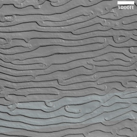
Cool image time! The picture to the right, cropped, reduced, and sharpened to post here, was taken on May 31, 2023 by the high resolution camera on Mars Reconnaissance Orbiter (MRO).

I think the many parallel ridges are likely hardened and petrified dunes of sand because of their craggy nature. Dunes of sand would have a smoother, softer look, and in fact, if you look at some of the dunes inside the depression at the bottom-right of the picture you will see ridges with exactly that look, smooth and curved.

Nor is it unreasonable to believe these ridges are petrified dunes, as orbital data over time has found that many of the dunes on Mars, even those that look active, are not and have likely been hardened for centuries.

As for the ridges running at right angles to each other in the picture’s middle left, I have no idea. Possible we are looking at ancient dykes of lava that pushed up through cracks and faults, but this is pure guess.
» Read more

1 22 23 24 25 26 271