NOAA today posted its monthly update of the solar cycle, covering sunspot activity for January. As I do every month, I am posting it here with annotations to give it context.

The graph above has been modified to show the predictions of the solar science community. The green curves show the community’s two original predictions from April 2007, with half the scientists predicting a very strong maximum and half predicting a weak one. The red curve is their revised May 2009 prediction.
Since my last solar cycle update, sunspot activity showed a slight increase in activity when compared to the previous month. Overall, however, the ramp down from solar maximum continues to underperform the predictions, and suggests that this solar maximum will not only be a very weak one, but a short one as well.
January’s activity however illustrated a statistical phenomenon that is typical of the sunspot count. That count is determined not by the numbers of sunspots on the entire surface of the Sun, but on the sunspots visible on the side of the Sun facing the Earth. Since it is not unusual for one face to be more active than the other, as we transition from maximum to minimum the sunspot counts will often show a more pronounced up-and-down curve reflecting this fact. Since the Sun’s day equals about 27 Earth days, this means that about every two weeks the active side will dominate our view until it rotates away and the inactive side reveals itself for two weeks.
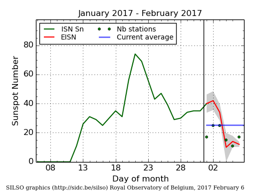
This pattern was very evident in January, as shown by the graph on the right and obtained from here. During the first two weeks of the month the Sun was blank. Then that inactive face rotated out of view. For the next two weeks or so the sunspot count went up, then began to drop as the active face began to rotate out of view to be replaced by the blank face last seen in early January.
This pattern of course is very fluid, as at any time the inactive face can become more active and the active face less so. Nonetheless, for short periods covering one to three months it helps to partly explain the up-and-down pattern of sunspot fluctuations during this time period when large portions of the Sun’s face are blank.
