The slowly disappearing dry ice cap at Mars’ south pole

The Happy Face crater near Mars' south pole
Click for the 2020 full image.

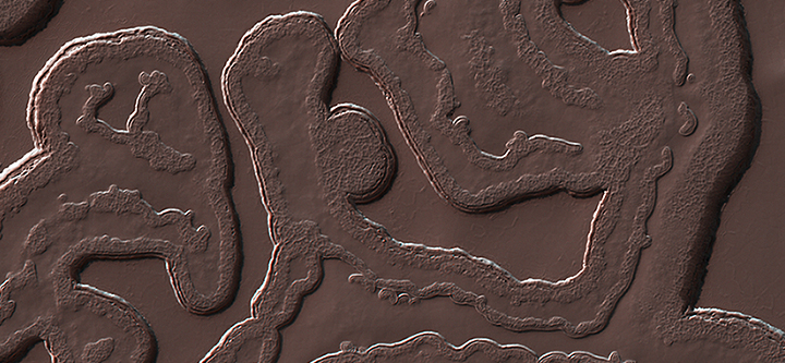
Cool image time! The photo to the right of two images taken by the high resolution camera on Mars Reconnaissance Orbiter (MRO) was posted as a captioned image by the orbiter’s science team today.

This crater, dubbed the Happy Face Crater because of the shape of the blobby features within it, is located on the south pole ice cap of Mars, about 200 miles from the south pole itself.

Today’s caption noted how these pictures, taken nine years apart, illustrate the change going on at the Martian south pole.

The “blobby” features in the polar cap are due to the sun sublimating away the carbon dioxide into these round patterns. You can see how nine years of this thermal erosion have made the “mouth” of the face larger. The “nose” consisted of a two circular depressions in 2011, and in 2020, those two depressions have grown larger and merged.

While this caption noted the importance of studying these long term changes in order to understand the evolution of Mars’ climate and geology, it did not give the very specific discovery these changes suggest for Mars globally, a discovery that is actually very significant.

The two ice caps of Mars have some fundamental differences, all presently unexplained. The similarities are obvious. Both have permanent caps of water ice that are presently believed to be in a steady state, not shrinking or growing. Both each winter get covered by a thin mantle of dry ice that sublimates away completely with the coming of spring.

The differences are more puzzling, as shown by the maps of the two poles below.
» Read more

8 comments

Curiosity checks out its wheels

One wheel on Curiosity, as seen in July 2020 and January 2021
For full resolution images, go here and here for the
top image, and here and here for the bottom image.

Having finished a two week look at a sea of sand, Curiosity’ science team has resumed its journey east towards the higher slopes of Mount Sharp.

Before they started out however, they decided to aim the rover’s high resolution mast camera at Curiosity’s wheels to see how they are faring and whether any of the damage that occurred in the early days of the mission has worsened. The photo on the right compares what was seen this week with the damage on the same wheel as seen in July 2020. This is also the same wheel I have posted images of since September 2017.

Not only does there appear to be no appreciable new damage to this wheel in the six months since July, remarkably, a comparison between today’s image and the photo from September 2017, shows little change as well.

In the more than three years since that 2017 photo, Curiosity has crossed Vera Rubin Ridge, crossed the clay unit, climbed up the next ridge to take a look at the incredibly rough terrain of the Greenheugh Pedimont, and then continued across the clay unit on its way to higher and possibly more challenging terrain.

In all those travels it appears this particular wheel has fared rather nicely, accumulating in at least this part little new damage. This bodes well for the rover’s future, as the wheels have been a concern since Curiosity’s first two years on Mars, when engineers found they were experiencing more damage than expected. The travel techniques they have adopted since to protect the wheels appear to be working.

4 comments

More evidence Mars’s glaciers formed across many ice ages

The uncertainty of science: New research using the boulders found on the top of Martian glaciers has now strengthened the evidence that Mars must have undergone many previous ice age cycles going back as much as 800 million years, with those glaciers waxing and waning during each cycle.

This new data helps map the cycles earlier than 20 million years ago, which have been difficult to map out based solely on the orbital data available from Earth and from Mars orbit. The results suggest that before then there were from six to twenty additional cycles during the last 300 to 800 million years.

These numbers are decidedly uncertain. It is likely that there were many more cycles, as suggested by the many layers seen at the edges of the north and south polar ice caps.

Be aware as well that if you read the press release you should know that it falsely implies that this research is the first to map out these ice age cycles. This is not true. All this research has done is provide more evidence for cycles prior to 20 million years ago, cycles that scientists have long believed must have happened based on other data.

In the end, for us to map out the full climate history of Mars will require numerous ice core samples at the planet’s poles, something that will not be possible until people are living and working on Mars routinely.

3 comments

Mysterious colors on Mars, near the landing site of Europe’s rover

Mysterious colors on Mars
Click for full image.

Cool image time! Today the science team for the high resolution camera on Mars Reconnaissance Orbiter (MRO) released a new captioned image, which I have cropped and reduced to post here to the right.

The photo was taken October 12, 2020, and shows a small very colorful area on top of an isolated hill. To quote the caption, written by Sharon Wilson:

An isolated, elongated mound (about 1 mile wide and 3.75 miles long) rises above the smooth, surrounding plains. Horizontal layers are exposed at the northern end of the mound, and its surface is characterized by a very unusual quasi-circular pattern with varying colors that likely reflect diverse mineral compositions.

…The origin of this mound is unknown, but its formation may be related to the clay-bearing rocks in the nearby Oxia Planum region.

» Read more

0 comments

Chang’e-5’s lunar samples less dense than expected

Because the lunar samples retrieved by China’s Chang’e-5 probe were less dense than expected, it ended up recovering only 3.8 pounds of material rather than the targeted 4.4 pounds.

The probe had estimated the lunar rocks to have a density of 1.6 grams per cubic millimetre, based on data from past missions by other countries, said Pei Zhaoyu, the mission spokesman. Going by that figure, the probe stopped taking samples after just 12 hours, apparently assessing that the target had been reached. “However, from tests, the actual density might not be that high,” Pei told reporters.

This is not a failure, but a discovery. In order to make sure the lander did not recover too much material, weighing too much, they needed to set limits based on the expected weight of the material recovered. That these samples taken from the Mons Rümker volcano complex are lighter than expected reveals something about them. It suggests the lava here was different than lava samples taken elsewhere.

3 comments

InSight scientists give up on heat sensor mole

After another failed attempt earlier this month to dig with the German-made mole on the InSight Mars lander, the science team has decided to abandon all further efforts.

After getting the top of the mole about 2 or 3 centimetres under the surface, the team tried one last time to use a scoop on InSight’s robotic arm to scrape soil onto the probe and tamp it down to provide added friction. After the probe conducted 500 additional hammer strokes on 9 January, with no progress, the team called an end to their efforts.

This means the heat sensor, one of the two instruments carried by InSight, is also a failure, and will not be able to provide any data about the planet’s interior temperature.

From the beginning InSight appears to have been a poorly run and badly chosen project. Other than a weather station, it carried only two instruments, a seismometer and a heat sensor. Its launch was delayed two years when the French attempt to build the seismometer failed and JPL had to take over, fortunately with success. Now the failure of the German-made mole has made the heat sensor a failure.

To send a lander to Mars at a cost of a billion dollars with so little payoff seems in hindsight to have been bad use of money. Plenty of other NASA planetary missions have done far better for far less.

24 comments

Another professor arrested for hiding ties to China

An MIT professor has been arrested for hiding his extensive ties to the Chinese communist government, even as he took almost $20 million in grants from the Department of Energy.

According to prosecutors, Gang Chen, a mechanical engineering professor at MIT, has held various positions on behalf of the PRC aimed at promoting China’s technological and scientific capabilities. He allegedly shared his expertise directly with Chinese government officials, “often in exchange for financial compensation,” said prosecutors in the U.S. attorney’s office in Boston.

The Chinese consulate in New York allegedly requested that Chen, a naturalized U.S. citizen, act as an “overseas expert” for the PRC. He was also a member of two talent programs that the PRC has used to place Chinese students at American universities.

This is not the NASA scientist who pled guilty to similar charges yesterday.

It appears to me that the Trump Justice Department is trying to wrap up as many of its cases of academics spying for China as it can before Joe Biden takes over.

4 comments

Craters in slush on Mars

Dust devil steak across a slushy plain on Mars
Click for full image.

Cool image time! The photo to the right, cropped and reduced to post here, was taken on October 27, 2020 by the high resolution camera on Mars Reconnaissance Orbiter (MRO). It was taken not for any particular research project, but as one of the periodic images the camera team needs to take maintain the camera’s proper temperature. When they need to do this, they often will take a picture in an area not previously viewed at high resolution. Sometimes the image is boring. Sometimes they photograph some geology that is really fascinating, and begs for some young scientist to devote some effort to studying it.

In this case the photo was of the generally featureless northern lowland plains. What the image shows us is a scattering of impact craters that appear to have cut into a flat plain likely saturated with ice very close to the surface.

How can I conclude so confidently that these craters impacted into ice close to the surface? The location gives it away.
» Read more

0 comments

The target landing ellipse on Mars for Perseverance

Perseverance's landing ellipse on Mars
Click for full image.

In just over a month, on February 18, 2021, the American rover Perseverance will come screaming through the thin atmosphere of Mars at a speed of over 12,000 miles per hour to hopefully land successfully in Jezero Crater.

The map to the right, cropped and reduced to post here, was released last week by the Perseverance science team and shows the landing ellipse in that crater. It also shows the much larger landing ellipses of previous landers/rovers. As they noted,
» Read more

3 comments

Giant iceberg from Antarctica breaking up

As should have been expected, the giant iceberg the size of Delaware that had broken from the Antarctic ice pack in 2017 and was drifting directly towards South Georgia Island (a wildlife preserve), is now breaking up without doing any harm to the island itself.

Seawater has been cutting like a knife through A-68A, the enormous Antarctic iceberg drifting in the southern Atlantic Ocean. On January 11, 2021, the Visible Infrared Imaging Radiometer Suite (VIIRS) on the NOAA-20 satellite acquired this image showing the remainder of A-68A, along with two large pieces that broke off in December 2020.

The U.S. National Ice Center (USNIC) reported on January 8 that A-68A measured 74 kilometers long and 44 kilometers wide. That equates to an area about twice the size of Houston—still sizable, but quite a bit smaller than its Delaware-sized status in July 2017 when it calved from the Larsen C Ice Shelf. The pieces that broke from A-68A in December (forming A-68D and A-68E) are smaller, but remain large enough to be tracked by the USNIC.

Every report about this, including today’s, waxes eloquently about the terrible threat the iceberg poses to the wildlife on South Georgia Island should it become grounded there, even though all past data, let me repeat, all past data indicated that it would not hit the island but drift around as it broke up.

And, surprise surprise, that is exactly what it has been doing.

4 comments

The colorful and bright knobs of Ariadnes Colles on Mars

Colorful and bright knob in Ariadnes Colles
Click for full image.

Today’s cool image gives us a sample of the strange colorful hills in an even stranger knobby depression on Mars called Ariadnes Colles. The photo to the right, cropped and color enhanced to post here, was taken on September 10, 2020 by the high resolution camera on Mars Reconnaissance Orbiter (MRO). It focuses on just one of those colorful hills. The color strip only covers the western half, which is why that is the only part of the hill in color.

Ariadnes Colles is a patch of chaotic terrain 110 by 100 miles in size, located in the southern cratered highlands due south of Mars’s volcano country, at latitude 34 degrees south. What makes this particular patch of chaos distinct from the many others on Mars is that the hills, knobs, and mesas within it are routinely bright and colorful, compared to the darker surrounding terrain. Moreover, as noted in this Mars Express press release for images of Ariadnes Colles from that orbiter,

In contrast to other chaotic terrains … Adrianes Colles is not a water-source region. It is still debated, therefore, whether Ariadnes Colles was formed by the action of water or wind.

The darker material in the southern areas is most likely sand or volcanic ash; some slopes of the flat-topped features have been covered by this dark material that was blown up on the slopes.

The sand or volcanic ash most likely come from the Medusae Fossae Formation several hundred miles to the north, the largest volcanic ash deposit on Mars. The colors on the hill likely come from a variety of minerals.

The overview map below shows the entire patch, with the location of the hill above indicated by the white dot in the red rectangle that shows the full image location.
» Read more

1 comment

Astronomers discover first periodic erupting supermassive black hole

Astronomers observing a galaxy 570 million light years away have discovered that the periodic energetic flares that occur there every 114 days are not supernovae but eruptions from the supermassive black hole at the center of the galaxy, caused each time an orbiting star gets too close during its perihelion and has material stripped away from it.

ASASSN-14ko was first detected by the All-Sky Automated Survey for Supernovae (ASAS-SN), a global network of 20 robotic telescopes headquartered at The Ohio State University (OSU) in Columbus. When Payne examined all the ASAS-SN data on the phenomenon, she noticed a series of 17 regularly spaced flares.

Based on this discovery, the astronomers predicted that the galaxy would experience another burst on May 17 of last year and coordinated ground- and space-based facilities to make observations. They have since successfully predicted and witnessed flares on September 7 and December 26.

Though the press release tries to sell itself by saying these flares were initially mistaken for supernovae, a close reading suggests the astronomers thought this for only a very short time. As soon as they took their first close look and noticed the regularly space events, they abandoned the supernovae idea immediately.

Most supermassive black holes at the center of galaxies are active, emitting large amounts of energy in bursts or in a steady stream. That is why astronomers label them Active Galactic Nuclei, or AGNs. This is the first to do so in a periodic manner.

That most are active illustrates the mystery of the supermassive black hole in the center of the Milky Way. Sagittarius A* (pronounced A-star) is not active, even though it really should be.

5 comments
1 245 246 247 248 249 729