
February 25, 2016 Batchelor/Zimmerman podcast
Below the fold. John gave me enough time to give a good and clear description of how gravity wave detectors work.
» Read more
Below the fold. John gave me enough time to give a good and clear description of how gravity wave detectors work.
» Read more
My how time flies: Astronaut Scott Kelly’s almost year-in-space is scheduled to end on March 1st.
Kelly and cosmonaut Mikhail Kornienko will come back to Earth Tuesday (March 1), wrapping up an unprecedented 340-day stay on the orbiting lab. (Crewmembers typically live and work aboard the station for 5 to 6 months at a time.)
The article is wrong when it calls this mission “unprecedented.” The Russians have flown four astronauts in space for more than a year, with one spending 14.5 months in orbit. Though Kelly’s experience will provide valuable data for future long term missions to the planets, it remains disappointing to me that NASA didn’t have the courage to push this beyond the previous Russian record.
The uncertainty of science: An analysis of scientific surveys suggests that one in five may contain fake data.
With few exceptions, they limited their analysis to studies that asked more than 1000 people at least 75 questions on a range of topics. And to be conservative, they forgave studies for which at least 95% of the data passed the test.
That made the results all the more worrying: Among 1008 surveys, their test flagged 17% as likely to contain a significant portion of fabricated data. For surveys conducted in wealthy westernized nations, that figure drops to 5%, whereas for those done in the developing world it shoots up to 26%.
To me the difference found between first and third world countries makes the results more believable. It suggests that survey companies who do these surveys have a problem that should be addressed. Instead, the research
is being hotly disputed by the Pew Research Center, one of the major funders of such surveys. And the organization has gone so far as to request the researchers desist from publishing their work.
Pew reviewed the questionable surveys and found evidence that the analysis produced some false positives. They used this as reason to reject its results entirely. That the analysis has also been successful in detecting fraud in several surveys apparently does not concern them.
After a week of testing scientists have now completely released LISA Pathfinder’s two gold-platinum cubes so that they are floating free within the spacecraft.
With the cubes released, the spacecraft is now measuring the position of each cube and using thrusters to adjust its position and keep the cubes floating within it. This success has essentially proven that the technology works, though they now have to see if the technology can be maintained in orbit for a long enough period of time to be worthwhile. If so, this mission will be followed by multiple similar spacecraft, flying in formation while also measuring their positions precisely relative to each other. If a gravitational wave rolls past, they will detect it by the tiny differences of each cube’s position, kind of like beach balls floating on the ocean as a wave rolls past.
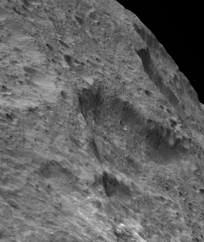
Cool image time! As Dawn continues its survey of Ceres the science team is beginning to release images looking sideways at the planet, rather than straight down, in order to get a better understanding of the topography. The image to the right is an example. It shows the area around 37-mile-wide Fluusa Crater. I have cropped it to emphasize the most rugged areas, especially the jagged cliff meandering away towards the horizon.
This image provides a hint at the differences between Ceres and the Moon. Up until now Dawn images have given the impression that Ceres is very much like the heavily cratered lunar surface. The terrain in this image however suggests to me that Ceres’ surface crust is much less dense because of the low gravity, and thus has a light puffy feel to it. The Moon’s surface is rarely this uneven, as its higher gravity has pounded things down, smoothing them out somewhat.
The Rosetta science team has released their first rough map of the geological regions of Comet 67P/C-G’s southern hemisphere, in darkness up until recently.
As Rosetta moves closer to the comet in the coming months, they will gather high resolution images of the south and compile them to produce a final map.
A toy boat launched by students in South Carolina has been found by beach-goers in Wales.
The boat had been launched by fourth graders from St Andrews School of Math and Science in Charleston as part of a project to teach students about the ocean. This was in May 2015. The Carolina Dreamer traveled over 6400 kilometers across the pond, making a pit stop in Bermuda along the way.
The students equipped the vessel with a time capsule and GPS tracker before sending it out to sea. Although it lost a sail along the way, the boat transmitted its location 16 kilometers from the town of Aberstwyth, prompting the teacher behind the idea, Amy McMahon, to contact the local marines.
The best part of the story? School officials in Wales are planning to launch the boat back towards the western hemisphere.
Data from New Horizons of the surface of Pluto’s moon Charon now suggests that the satellite once had an underground ocean that is now frozen.
Charon’s outer layer is primarily water ice. When the moon was young this layer was warmed by the decay of radioactive elements, as well as Charon’s own internal heat of formation. Scientists say Charon could have been warm enough to cause the water ice to melt deep down, creating a subsurface ocean. But as Charon cooled over time, this ocean would have frozen and expanded (as happens when water freezes), pushing the surface outward and producing the massive chasms we see today.
The Indian government today approved construction of LIGO-India, using some duplicate components already available from the American LIGO gravitational wave detector.
“We have built an exact copy of that instrument that can be used in the LIGO-India Observatory,” says David Shoemaker, leader of the Advanced LIGO Project and director of the MIT LIGO Lab, “ensuring that the new detector can both quickly come up to speed and match the U.S. detector performance.” LIGO will provide Indian researchers with the components and training to build and run the new Advanced LIGO detector, which will then be operated by the Indian team.
What this new instrument will accomplish is to give astronomers more information when a gravitational wave rolls past the Earth. By having detectors half a world apart, they will be able to better triangulate the direction the wave came from, which in turn will help astronomers eventually pinpoint its source event.
Worlds without end: Using the Hubble Space Telescope astronomers have measured the daily rotation of a super Jupiter exoplanet 170 light years away.
They estimate, based upon brightness variations attributed to clouds in the upper atmosphere, that the rotation rate is about 10 hours long. We should all recognize however the significant uncertainty of this number. Clouds change, as do weather conditions. The data only gives us a hint at what is going on here.
After a scrub last week due to weather, Japan today successfully launched a new X-ray space telescope, Astro-H.
I await the announcement of the telescope’s new official name. Update: The name is Hitomi, which means “eye” or “aperture” in Japanese.
Below the fold is my podcast with John Batchelor tonight. Subjects: India in space and on the ground, SpaceX, the writing on the walls of the Apollo 11 capsule, Philae, SuperEarths, gravitational waves, and Pluto.
» Read more
This article provides a nice detailed look at China’s planned space science missions, including an X-ray space telescope that will look for the X-ray counterparts of gravitational wave events. They also hope to launch their first Mars mission, which will include a lander, orbiter, and rover, by 2020.
Worlds without end: Using the Hubble Space Telescopes astronomers have made the first chemical analysis of a SuperEarth’s atmosphere.
The planet, 55 Cancri e, is estimated to have a mass of eight Earths. Its atmosphere was found to have hydrogen, helium, and the molecule hydrogen cyanide. No water was detected.
Astronomers have used Hubble to detect the components of a number of exoplanets, but these have all been giant planets more like Jupiter. This is the first measurement of an exoplanet whose mass is small enough that it might be rocky, like Earth.
More gravitational wave news: LISA Pathfinder’s two gold-platinum 46mm cubes have been released and are now floating free inside their spacecraft.
After a week of further testing, they will stop controlling the cube’s positions with electrostatic force. They will then watch them very precisely with lasers to test whether the equipment is capable of detecting distance shifts small enough for a future version, made up of three such spacecraft, to detect gravitational waves. The idea is that, as a wave rolls by, the cubes will shift positions at slightly different times, just as different beach balls will do so on ocean waves.
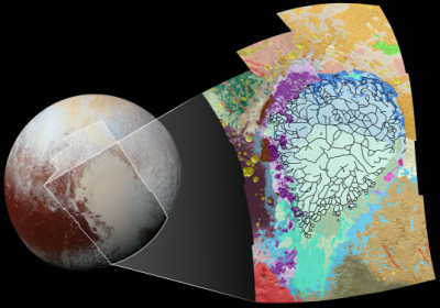
The New Horizons science team has now released the first geology map of a portion of Pluto, seen by the spacecraft during its fly-by last year.
It is definitely worth your while to take a look at the full image, along with the legend explaining the different surface features. Most of the geological terms are merely descriptive, but the careful breakdown still provides a much deeper understanding of what is there.
Scientists have found a way to use tiny nanoparticles of gold to destroy 100% of the cancer cells in mice.
The engineering is complex, but the nanoparticles tend to cluster around cancer cells, and when heated cause water around them to vaporize, destroying the cells. Human trials expected within two years.
Want to not attract annoying bugs? Use warm LEDs!
The research’s amusing discovery is that bug lights, which are designed to not attract bugs and were proved to work very well, had one failing: They did not repel two species, stink bugs and earwigs. Looks like warm LEDs (red or yellow in color) are the thing to get.
The uncertainty of science: A new analysis of the the 1859 giant solar storm, the first ever detected and dubbed the Carrington event after the scientist who discovered it, suggests that its strength was not global as previously believed, and that it only effected a few spots on Earth.
Up until now the Carrington event has been considered the strongest solar storm to ever hit the Earth, and has been used by the solar satellite industry as a wedge to demand funding for solar warning satellites, claiming that if a similar storm was to ever hit the Earth again without warning, it would destroy civilization as we know it. This new data suggests that this threat has been over-stated.
Why am I not surprised?
The uncertainty of science: Even as NASA officials poo-poo the suspected meteorite impact in India that killed a bus driver, India scientists have done a chemical analysis of one of the rocks found near the site and found it to be a meteorite fragment.
According to a preliminary report by National College Instrumentation Facility (NCIF) in Trichy, a Scanning Electron Microscope (SEM) study on samples retrieved from the campus in Vellore where the blast occurred shows the “presence of carbonaceous chondrites”.
“Carbonaceous denotes objects containing carbon or its compounds and chondrites refer to non-metallic meteorite parts containing mineral granules,” K Anbarasu, a geologist who is also principal of the Trichy-based National College, told The Indian Express.
There remains uncertainty because the fragments tested did not actually come from the impact crater itself.
Anbarasu said the preliminary SEM study was conducted on “small pieces of black material” found near the blast site. “The crater formed at the spot had been already disturbed by other investigators. So we inspected the entire campus as any meteor incident would scatter several objects across the area before landing. Finally, we spotted several small pieces of this black material, one the size of a paperweight, on the terrace of a building nearby,” Anbarasu said.
Nonetheless, I think it unprofessional and inappropriate for a NASA official to comment on this event half a globe away. There is no way that they can really determine anything from the available photos taken of the impact site, and thus they should shut up.