Buried ridges at the bottom of a Martian abyss

Buried ridges in a Martian abyss
Click for full image.

Today’s cool image could be labeled a “What the heck?!” photo, as the origin of its most distinct feature is utterly baffling. The picture to the right, cropped, reduced, and sharpened to post here, was taken on June 18, 2023 by the high resolution camera on Mars Reconnaissance Orbiter (MRO), and shows what look like a collection of meandering ridges peeking out from a terrain covered by thick dust.

The scientists label this dust-covered ground, as well as the ripple dunes to the south in the full image, “sand sheets.” Without question, the ground here seems to resemble a Sahara-like terrain. It is utterly featureless, other than the few bedrock features that poke up out of that sand. In the full image some peaks stick out, but it the meandering ridges in this section that are most intriguing. They are reminiscent of rimstone dams in caves, but what formed them remains baffling, since cave rimstone dams are formed by the interaction of limestone and water, and there is absolutely no evidence of any near surface ice at this location in the dry equatorial regions of Mars.

All the ridges signify is a buried terrain formed in some inexplicable way.
» Read more

Scientists believe they have recovered the first known interstellar meteorite

A scientific expedition in the Pacific off the coast of Papua New Guinea has found what it thinks are spherules from the first known interstellar meteorite that hit the Earth on January 8, 2014 and dubbed IM1. From their preprint paper [pdf]:

On 8 January 2014 US government satellite sensors detected three atmospheric detonations in rapid succession about 84 km north of Manus Island, outside the territorial waters of Papua New Guinea (20 km). Analysis of the trajectory suggested an interstellar origin of the causative object CNEOS 2014-01-08: an arrival velocity relative to Earth in excess of ∼ 45 km s−1, and a vector tracked back to outside the plane of the ecliptic. The object’s speed relative to the Local Standard of Rest of the Milky-Way galaxy, ∼ 60 km s−1, was higher than 95% of the stars in the Sun’s vicinity.

In 2022 the US Space Command issued a formal letter to NASA certifying a 99.999% likelihood that the object was interstellar in origin.

Using a “magnetic sled” that they dragged across the seafloor, the scientists collected about 700 spherules thought to come from the meteorite, of which 57 have been analyzed and found to have properties that confirm their interstellar origin. As they note in their paper, “The spherules with enrichment of beryllium (Be), lanthanum (La) and uranium (U), labeled “BeLaU”, appear to have an exotic composition different from other solar system materials.”

The “BeLaU” elemental abundance pattern does not match terrestrial alloys, fallout from nuclear explosions, magma ocean abundances of Earth, its Moon or Mars or other natural meteorites in the solar system. This supports the interstellar origin of IM1 independently of the measurement of its high speed, as reported in the CNEOS catalog and confirmed by the US Space Command.

Based on the sparse data, the scientists speculate that these spherules could have come from the crust of an exoplanet, the core collapse of a supernova, the merger of two neutron stars, and even possibly “an extraterrestrial technological origin.” They have no idea, but all these are among the possibilities.

Pragyan snaps first pictures of Vikram sitting on the Moon

Vikram as seen by Pragyan
Click for original image.

India’s space agency ISRO has released the first two pictures from the Pragyan rover showing the Vikram lander that bought both to the Moon safely.

The picture to the right is the close-up image, which shows two of Vikram’s science instruments. CHASTE is a probe that has been measuring the temperature of the Moon’s regolith at this spot, while ILSA is a seismometer for measuring the seismicity around the landing site.

Both spacecraft have been on the lunar surface now for one week, which means they are both halfway through their nominal two-week mission that lasts until lunar sunset, occurring on September 4th. Neither were designed to survive the 14-day-long lunar night, though engineers will attempt to kept both alive.

Update on the ongoing research of the closest supernovae in a decade

Gemini North image of supernova in Pinwheel Galaxy
Click for original image, taken by the Gemini North telescope in Hawaii.

Link here. Though the press release from UC-Berkeley focuses mostly of research being done by its astronomers, it also provides a very good overview of what all astronomers worldwide have been learning since Supernova SN 2023ixf was first discovered by amateur astronomer Koichi Itagaki in Japan on May 19, 2023 in the Pinwheel Galaxy, only 20 million light years away. This tidbit is probably the most significant:

Another group of astronomers led by Ryan Chornock, a UC Berkeley adjunct associate professor of astronomy, gathered spectroscopic data using the same telescope at Lick Observatory. Graduate student Wynn Jacobson-Galán and professor Raffaella Margutti analyzed the data to reconstruct the pre- and post-explosion history of the star, and found evidence that it had shed gas for the previous three to six years before collapsing and exploding. The amount of gas shed or ejected before the explosion could have been 5% of its total mass — enough to create a dense cloud of material through which the supernova ejecta had to plow.

Such data is going to help astronomers better predict when a star is about to go boom, by identifying similar behavior.

The prevailing winds in Mars’ volcano country

The prevailing winds in Mars' volcano country
Click for original image.

Today’s cool image is actual one new picture and four past images, which taken together reveal something about the larger wind patterns on Mars. The picture to the right, cropped, reduced, and sharpened to post here, was taken on June 27, 2023 by the high resolution camera on Mars Reconnaissance Orbiter (MRO) and shows a tiny wind-swept section of the giant volcanic ash field dubbed the Medusae Fossae Formation, about the size of the subcontinent of India and thought to be source of most of the dust on Mars.

The innumerable parallel thin ridges here all suggest that the prevailing winds blow from the southeast to the northwest. As they blow, the scour the surface ash out, and sometimes reveal the underlying bedrock, which here shows up as those small peaks and a handful of northeast-to-southwest trending larger ridges. Note too that the picture shown is only a small section of the full image, which shows that this landscape continues for a considerable distance in all directions.
» Read more

InSight team releases a global map of Mars’ seismic zones

Global map of quakes on Mars
Click for original image.

In a new paper that reviewed the entire archive of Mars quakes detected by the seismometer on InSight during its four years of operation on the Martian surface from 2018 to 2022, scientists have now released an updated global map showing the regions on Mars where seismic activity is most common. From the abstract:

Seismicity on Mars occurs mostly along or north of the boundary between the southern highlands and northern lowlands. Valles Marineris is seismically more active than previous catalogs of located events imply. Further, we show evidence that two events likely originate from the Olympus Mons region.

The map to the right is figure 6 from the paper, and shows clearly the sum total of InSight’s data. The yellow triangle marks InSight’s landing spot. The red line delineates the distant quakes from the nearby quakes detected by InSight. The green line is what the scientists identify as the border between the northern lowland plains and the southern cratered highlands. The data suggests that transition point could be linked geologically in some manner to the quakes themselves.

Though the majority of the detected quakes were in the Cerberus Fossae region, the data also suggests two other seismic active regions, one under the giant canyon Valles Marineris and the other south of Mars’ largest volcano, Olympus Mons.

Residue ice in southern mid-latitude Martian crater?

Residue ice in the southern mid-latitudes of Mars?
Click for original image.

Cool image time! The picture to the right, rotated, cropped, reduced, and sharpened to post here, was taken on April 10, 2023 by the high resolution camera on Mars Reconnaissance Orbiter (MRO). It shows an unnamed 1.2-mile-wide crater at about 35 degrees south latitude with what appears to be residual glacial ice hugging its north interior wall.

As this is in the southern hemisphere, the ground immediately below the south-facing interior wall of the crater is going to be in shadow the most, and thus it will also be the place where any surface or near-surface ice will survive the longest. In this case it appears that from the bumpy nature of that residual ice it has also been sublimating away. Within it however remains the faint hint of multiple layers, suggesting about a dozen past climate cycles with each new cycle producing a new but smaller layer with less ice.

The material in the southern half of the crater floor appears to be dust formed into ripple dunes.
» Read more

JAXA scrubs launch of X-Ray telescope & SLIM lunar lander due to high winds

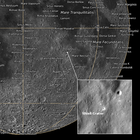
SLIM's landing zone
Click for interactive map.

Because of high winds, Japan’s space agency JAXA yesterday scrubbed the last launch of its H2A rocket, carrying the XRISM X-Ray telescope and the SLIM lunar lander.

A nice description of both payloads can be found here. XRISM is a simplified reflight of the Hitomi X-Ray telescope that failed immediately after launch in 2016.

Though SLIM carries a camera and two secondary payloads, both designed to hop along on the surface and obtain some data, its main mission is engineering, testing whether a robotic spacecraft can achieve a precision landing with a target zone of 100 meters, or 310 feet. The map to the right shows SLIM’s landing site, with the white dot in the close-up inset a rough approximation of that entire target zone. If successful this technology will make it possible to put unmanned planetary probes in places previously thought too dangerous or rough.

All three craft are designed to operate for only about fourteen days, during the daylight hours of the 28-Earth-day-long lunar day.

Flow channels on Mars

Flow channels on Mars
Click for original image.

Cool image time! The picture to the right, rotated, cropped, reduced, and sharpened to post here, was taken on May 13, 2023 by the high resolution camera on Mars Reconnaissance Orbiter (MRO). It shows what the scientists call a “channel and depression”, though to my eye everything looks like flow channels, descending to the east.

The drop from the narrow northern channel to wider southern channel is about 200 feet, with the small crater on the left sitting about halfway between. To our Earthbound eyes, something clearly flowed downhill from that northern channel into the wider channel. What we don’t know now is what the material was that did the flowing?

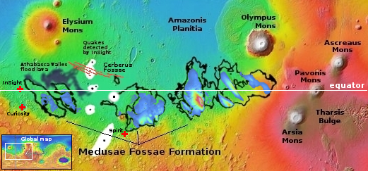
Was it liquid water? Glaciers? The overview map below provides some context, though it doesn’t actually provide an answer.
» Read more

Both Vikram and Pragyan functioning as planned on the Moon

Pragyan on the Moon
Click to see full movie.

According to tweets from India’s space agency ISRO, both the Vikram lander and the Pragyan rover are functioning as planned on the lunar surface, with the rover successfully activating its two science instruments.

The image to the right, taken by Vikram, shows the rover as it completed its roll down the ramp onto the lunar surface. This is a screen capture from a movie showing that roll down, which you can see by clicking on the picture. Since then it has moved another 26 feet from the lander.

I must add once again that Vikram did not land “on the south pole”, as too many so-called news organizations have been falsely claiming. It landed at about 69 degrees south latitude, quite a distance from that pole, in a flat region with no permanently shadowed craters. It is not specifically looking for water, though its instruments might help explain the orbital data that suggests there are areas on the surface of the Moon where hydrogen is somehow present.

If so many news outlets can’t seem to get these very basic facts about this mission correct, one must ask what else do they get wrong routinely? I don’t ask, because I always assume their information is wrong, check it constantly, and find repeatedly that they get numerous basic facts incorrect, especially when it comes to reporting on politics.

Big mountains everywhere inside Valles Marineris

Big mountains in Valles Marineris
Click for original image.

While the giant canyon Valles Marineris on Mars is known best as the biggest known canyon in the solar system — large enough to cover the continental United States several times over — that size tends to diminish the mountainous nature of its interior. Today’s cool image attempts once again (see for example these earlier posts here, here, here, here, and here) to illustrate that stupendous and mountainous nature.

The picture to the right, rotated, cropped, reduced, and sharpened to post here, was taken on May 15, 2023 by the high resolution camera on Mars Reconnaissance Orbiter (MRO). The goal of the picture was to get a better view of the numerous layers of this terraced cliff wall. What I see, however from my tourist’s perspective, is a steep wall that descends almost 4,500 feet from the high to the low point in just over three miles. This is as steep if not steeper than the walls of the Grand Canyon.
» Read more

India’s Pragyan rover has successfully been deployed on the lunar surface


Click for interactive map.

According to a tweet from India’s space agency ISRO late yesterday, the Pragyan rover has successfully rolled down its ramp and is now deployed on the lunar surface.

No further updates have yet been released. According to ISRO’s mission webpage the instruments on both Vikram and Pragyan are as follows:

Lander payloads: Chandra’s Surface Thermophysical Experiment (ChaSTE) to measure the thermal conductivity and temperature; Instrument for Lunar Seismic Activity (ILSA) for measuring the seismicity around the landing site; Langmuir Probe (LP) to estimate the plasma density and its variations. A passive Laser Retroreflector Array from NASA is accommodated for lunar laser ranging studies.

Rover payloads: Alpha Particle X-ray Spectrometer (APXS) and Laser Induced Breakdown Spectroscope (LIBS) for deriving the elemental composition in the vicinity of landing site.

Pragyan’s two spectroscopes are likely similar to instruments on Curiosity and Perseverance on Mars, and allows some good surface analysis. Without a scoop however there will be no analysis of anything below the ground, unless the rover can upend a rock using its wheels.

Where the Martian landscape begins to dry out

Where Mars begins to dry out
Click for original image.

Today’s cool image to the right, cropped, reduced, and sharpened to post here, provides us a glimpse at the lower mid-latitudes of Mars where the terrain is beginning to dry out as we move south. The picture was taken on April 29, 2023 by the high resolution camera on Mars Reconnaissance Orbiter (MRO), and shows what the scientists label “large linear features.”

The main north-south ridge is only about 20-25 feet high, and its meandering nature (which can be seen more clearly in the full image) suggests it is possibly an inverted channel, formed when the bed of a former canyon gets compressed by the water or ice that flows through it, and when the surrounding terrain gets eroded away that channel bed becomes a ridge.

These ridges however could also possibly be volcanic dikes, where magma had pushed up through fractures and faults to form these more resistant ridges.
» Read more

India successfully lands Vikram on the Moon


Click for interactive map.

India this morning successfully placed its Vikram lander, carrying its Pragyan rover, on the surface of the Moon in the high southern latitudes.

I have embedded the live stream below, cued to just before landing.

The next challenge is getting Pragyan to roll off Vikram, and spend the next two weeks exploring the nearby terrain. The mission of both it and Vikram is only planned to last through the daylight portion of the 28-day-long lunar day, so it is not expected for either to survive the lunar night. Both will make observations, but the main purpose of this mission has already been accomplished, demonstrating that India has the technological capability to land an unmanned spacecraft on another planet. That the landing was in the high southern latitudes added one extra challenge to the mission.

» Read more

I will NOT wear a mask, part two

Here we go again! When the first panic over COVID arrived in 2020 and government thugs and their leftist minions in the culture began demanding that everyone wear a mask, I wrote the following:

It apparently has not been enough that they have successfully destroyed a thriving economy, put millions out of work, destroyed the airline, entertainment, sports, and restaurant industries, over a disease that, at best is nothing more than a slight blip in the overall death rate, and at worst will be comparable to similar past epidemics that we lived through without government-imposed panic or economic disaster.

No, destroying millions of lives has not been enough. They need to do more. They need to find more ways to squelch our freedom, nullify the Constitution and the Bill of Rights, and, to paraphrase Orwell, stamp a boot down on our faces, forever.

And in this case, they mean to do this, almost literally.

They are now beginning to demand that we wear masks at all times in public, in the mindless and stupid belief that this will somehow stop COVID-19 from spreading.

I also declared unequivocally that I would not wear a mask, “and if you demand it of me you will have a revolution on your hands.”
» Read more

The very tip of a thousand-mile-long crack on Mars

The very tip of a 1000-mile-long Martian crack
Click for original image.

Cool image time! The picture to the right, rotated, cropped, reduced, and sharpened to post here, was taken on June 22, 2023 by the high resolution camera on Mars Reconnaissance Orbiter (MRO). It shows what the scientists label as “The tip of Cerberus Fossae,” a thousand-mile-long crack in the surface of Mars formed when the ground was pulled apart by underground forces.

If you look closely at the picture’s right edge, you can see that beyond the end of the fissure it actually continues but appears filled with material. In the full picture this however is the end of the crack. Beyond this point the ground is as smooth and as generally featureless as seen within the picture itself, and as also shown in this MRO context camera view of the same area.

Cerberus Fossae is actually three parallel cracks, with this the northernmost one. The eastern tip of the middle crack was previously highlighted in a cool image in July 2022.
» Read more

Russian engineers pinpoint approximate crash site of Luna-25

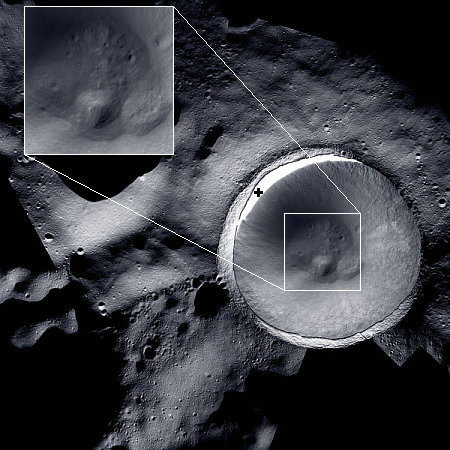
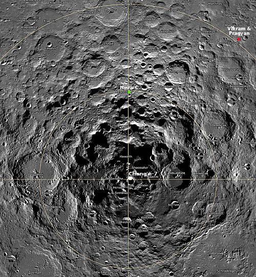
Russian engineers have pinpointed the approximate crash site of Luna-25 on the Moon as the 42-mile-wide crater Pontecoulant G, located at about 59 degrees south latitude, 66 east longitude.

Researchers from the Russian Academy of Sciences’ Keldysh Institute of Applied Mathematics have simulated the trajectory of the Luna-25 mission, figuring out where and when it crashed into the moon’s surface, the institute said in a statement on Telegram. “The mathematical modeling of the trajectory of the Luna-25 spacecraft, carried out by experts from the Ballistic Center of the Russian Academy of Sciences’ Keldysh Institute of Applied Mathematics, made it possible to determine the time and place of its collision with the moon,” the statement reads.

According to the institute, the spacecraft fell into the 42-kilometer Pontecoulant G crater in the southern hemisphere of the moon at 2:58 p.m. Moscow time on August 19.

The planned landing site, in Boguslawsky Crater at 73 degrees south latitude and 43 degrees east longitude, was many miles away.

It is time to devalue the software research of climate models

When the table of contents of the most recent issue of the American Geophysical Union’s (AGU) Geophysical Research Letters was released on August 16, 2023, I could not help noticing it contained a string of papers repeatedly showing that the models used to prove the coming fire of global warming continue to remain untrustworthy and unreliable. All of the following papers indicated biases and uncertainties of both climate models as well as the data they used, and each did so in their titles:

All of these papers considered the models valid for future research, and were instead focused on refining and increasing the accuracy of the models. All however showed once again how little we should trust these models.

What makes the publication of these papers significant is that it was the AGU that published them, even though the AGU has a decidedly biased editorial policy in favor of global warming. Despite the AGU’s insistence that “realistic and continually improving computer simulations of the global climate predict that global temperatures will continue to rise as a result of past and future greenhouse gas emissions,” it still cannot avoid publishing papers that repeatedly disprove that conclusion.
» Read more

A Martian wedding cake surrounded by brain terrain

Brain terrain surrounding a Martian wedding cake
Click for original image.

Of all many cool images I’ve posted, today might take the cake (pun intended) for the best illustration of the alien nature of Mars. The picture to the right, cropped, reduced, and sharpened to post here, was taken on June 28, 2023 by the high resolution camera on Mars Reconnaissance Orbiter (MRO), and shows what the scientists simply label as “flow features.”

I personally don’t see any obvious flow features in the full image, unless one wants to call the brain terrain that covers this entire plain a flow feature. Brain terrain is a feature unique to Mars whose origin remains a mystery to geologists. As noted by scientists in captioned MRO image in 2019:

You are staring at one of the unsolved mysteries on Mars. This surface texture of interconnected ridges and troughs, referred to as “brain terrain” is found throughout the mid-latitude regions of Mars.

…This bizarrely textured terrain may be directly related to the water-ice that lies beneath the surface. One hypothesis is that when the buried water-ice sublimates (changes from a solid to a gas), it forms the troughs in the ice. The formation of these features might be an active process that is slowly occurring since HiRISE [MRO’s high resolution camera] has yet to detect significant changes in these terrains.

The wedding cake inside the small crater to the upper right only adds to the alienness of this terrain.
» Read more

Watch the landing attempt of Chandrayaan-3’s Vikram lander on August 23, 2023


Click for interactive map.

After separating from its Chandrayaan-3 propulsion module on August 17, 2023, India’s Vikram lunar lander has been slowly making orbital adjustments in preparation for its landing attempt on August 23rd.

I have embedded the live stream of that landing attempt below. As it is scheduled for 6:04 pm (India time), in India, in the U.S. that landing will occur in the early morning hours of August 23rd.

Following the failed crash on the Moon of Russia’s lunar lander Luna-25 yesterday, this landing attempt is likely to garner a lot more interest. It is also India’s second attempt, having failed in 2019 when its Vikram lander ran out of fuel before landing and crashed.
» Read more

Luna-25 fails to enter orbit for landing on Moon

Though it is in lunar orbit, Russia’s Luna-25 lander today was unable to perform an engine burn as planned to place it in its final orbit for landing.

“Today, in accordance with the flight program of the Luna-25 probe, at 2:10 p.m. Moscow time, a command was issued to the probe to enter the pre-landing orbit. During the operation an emergency occurred on the space probe that did not allow it to perform the maneuver in accordance with the required parameters,” Roscosmos said.

Engineers are analyzing the issue, but no other information was released.

This issue could simply be the spacecraft’s computer aborted the engine burn because it sensed something not right, and that after some correction another burn can follow later. Under this circumstance the landing attempt would simply be delayed.

It is also possible something happened during that engine burn, and the spacecraft is either in an incorrect orbit, or might even be lost entirely. Stay tuned.

Hacker attack on Gemini North telescope in Hawaii shuts down many U.S.-run telescopes

A attack by hackers against the Gemini North telescope in Hawaii on August 1, 2023 has forced the National Science Foundation (NSF) to shut down all the telescopes it operates.

NOIRLab, the NSF-run coordinating center for ground-based astronomy, first announced the detection of an apparent cyberattack on its Gemini North telescope in Hilo, Hawaii, in a 1 August press release. Whatever happened may have placed the instrument in physical jeopardy. “Quick reactions by the NOIRLab cyber security team and observing teams prevented damage to the observatory,” the center’s release said.

In response to the incident, NOIRLab powered down all operations at the International Gemini Observatory, which runs the Hilo telescope and its twin, Gemini South, on Cerro Pachón mountain in Chile. (The latter was already offline for a planned outage.) Together, the two 8.1-meter telescopes have revealed vast swaths of celestial wonders—from the birth of supernovae to the closest known black hole to Earth.

Normally, NOIRLab’s computer systems let astronomers remotely operate a variety of other optical ground-based telescopes. But on 9 August the center announced it had also disconnected its computer network from the Mid-Scale Observatories (MSO) network on Cerro Tololo and Cerro Pachon in Chile. This action additionally made remote observations impossible at the Víctor M. Blanco 4-meter and SOAR telescopes. NOIRLab has stopped observations at eight other affiliated telescopes in Chile as well.

The attack has shut down ten telescopes entirely, some of which are the largest in the world, while other telescopes are operating but only allowing in-person operations.

Luna-25 takes first image of lunar surface

Luna-25's first lunar image
Click for interactive map. Zeeman is located on the lower left.

Russia’s state-run press today issued the first picture taken by Luna-25 after entering lunar orbit two days ago. That picture, to the right and cropped and reoriented to post here, shows part of Zeeman Crater at 75 degrees south latitude and 135 degrees west, on the far side of the Moon. From the TASS announcement:

“The Luna-25 spacecraft, flying in a circular orbit as the Moon’s artificial satellite, has taken pictures of the lunar surface with television cameras of the STS-L system. The image, taken today at 08:23 Moscow time, shows the southern polar crater Zeeman on the far side of the Moon. The coordinates of the crater center are 75 degrees south and 135 degrees west,” the state corporation said. Roscosmos said the Zeeman crater is of great interest to researchers. Its rim rises eight kilometers above its relatively flat floor.

The picture shows Zeeman’s southern rim to the left, with its pockmarked crater floor to the right. The crater the lander is targeting, Broguslawsky Crater, sits in the opposite hemisphere of Zeeman, slightly closer to the south pole but on the Moon’s near side.

The inexplicable behavior of Martian dust devils

The inexpicable behavior of Martian dust devils
Click for original image.

Today’s cool image illustrates the puzzling inclination of Martian dust devils to strongly favor specific regions on the Martian surface, for reasons that at present no one can confidently explain.

The picture to the right, rotated, cropped, reduced, and sharpened to post here, was taken on June 28, 2023 by the high resolution camera on Mars Reconnaissance Orbiter (MRO). It shows a plethora of dust devil tracks, almost all of which have an east-west orientation. Moreover, the tracks seem uninfluenced by the surface topography, continuing on their path without deviation, even as they cross cliffs, craters, and mounds. The orientation tells us the direction of the prevailing winds, though I don’t know if those winds blow to the east or to the west.

What makes this image revealing is that a gathering of such dust devil tracks is seen so rarely in other MRO high resolution photographs. I look at a lot of MRO pictures, and though dust devil tracks are not rare, most images don’t show this many. Apparently, there are specific conditions on Mars that cause a lot of tracks to appear in specific locations, either because atmospheric conditions create a lot more dust devils, or the ground conditions allow the tracks to become more visible.
» Read more

Scientists: Neptune’s clouds appear to ebb and grow in conjunction with sunspot cycle

Graph showing correlation between Neptune's clouds and the sunspot cycle

Scientists have now discovered what appears to be a link between the coming and going of clouds on Neptune to the Sun’s 11-year-long sunspot cycle, despite Neptune receiving only 1/900th the sunlight of the Earth.

To monitor the evolution of Neptune’s appearance, Chavez and her team analyzed images taken from 1994 to 2022 using Keck Observatory’s second generation Near-Infrared Camera (NIRC2) paired with its adaptive optics system (since 2002), as well as observations from Lick Observatory (2018-2019) and the Hubble Space Telescope (since 1994). In recent years the Keck Observatory observations have been complemented by images taken as part of Keck Observatory’s Twilight Observing Program and by Hubble Space Telescope images taken as part of the Outer Planet Atmospheres Legacy (OPAL) program.

The data revealed an intriguing pattern between changes in Neptune’s cloud cover and the solar cycle – the period when the Sun’s magnetic field flips every 11 years, causing levels of solar radiation to fluctuate. When the Sun emits more intense ultraviolet (UV) light, specifically the strong hydrogen Lyman-alpha emission, more clouds appear on Neptune about two years later. The team further found a positive correlation between the number of clouds and the ice giant’s brightness from the sunlight reflecting off it.

“These remarkable data give us the strongest evidence yet that Neptune’s cloud cover correlates with the Sun’s cycle,” said de Pater. “Our findings support the theory that the Sun’s UV rays, when strong enough, may be triggering a photochemical reaction that produces Neptune’s clouds.”

The graph to the right shows the correlation between the clouds and the sunspot cycle. The paper is available here.

This conclusion remains uncertain because of the overall sparseness of the data. Yet, it is intriguing, and also underlines the importance of the Sun on the Earth’s climate. If the solar cycle can impact Neptune’s climate so significantly from 2.8 billion miles away, it certainly must have a major impact on the Earth’s climate at only 100 million miles distance.

Chandrayaan-3’s Vikram lander separates from its propulsion module; Luna-25 in lunar orbit


Click for interactive map.

The two probes aiming to land in the high southern latitudes of the Moon in the next week are now both in lunar orbit and preparing for their planned landings.

First India’s Chandrayaan-3: With its propulsion module having completed the job of getting Chandrayaan-3 from Earth to lunar orbit, the Vikram lander today separated from that module in preparation for firing its own engines on August 23, 2023 and landing on the Moon.

Vikram needs to make several orbital adjustments before that landing attempt.

Second, Russia’s Luna-25 probe entered lunar orbit yesterday, where it will spend the next few days making its own orbital adjustments before attempting its landing on August 21st.

Vikram carries a small rover, Pragyan. Luna-25 is only a lander, though it has a scoop and will do analysis of the lunar soil below it. Neither is landing “near the south pole”, as most news sources are saying. They are landing at latitudes comparable to landing in the Arctic on Earth, on the northern coast of Alaska. As such, neither will find out anything about the question of remnant ice in south pole’s permanently shadowed regions.

An avalanche in the West Virginia of Mars

An avalanche in the West Virginia of Mars
Click for original image.

Cool image time! The picture to the right, rotated, cropped, and reduced to post here, was taken on June 27, 2023 by the high resolution camera on Mars Reconnaissance Orbiter (MRO).

I have cropped it to focus on this one hill, about 900 feet high (though the elevation data from MRO is somewhat uncertain at this resolution), because of that major landslide on its northern slopes. At some point in the past a major piece of the exposed bedrock at the top broke off and slide about halfway down the mountain, almost as a unit, settling on the alluvial fill that comprises the bottom half of the hill’s flanks.

The bedrock surrounding the peak is also of interest because of its gullies, all of which were created by downward flowing material. Was it ice? Water? Sand? Or maybe a combination of two or three? If water or ice was involved it was a very long time ago, as this location is in the dry equatorial regions of Mars. There is little known near-surface ice here.
» Read more

Scientists discover in Alaska the largest dinosaur track site in U.S.

New dinosaur track site in Alaska
Click for original image.

Paleontologists have discovered in Alaska a new dinosaur track site that appears to contain numerous exposed tracks on what is now a series of vertical walls covering an area larger than a football field.

The picture to the right shows the entire site. The darker flat walls that appear to be dimpled are the track sites, with the dimples the actual tracks.

Researchers at the University of Alaska Fairbanks made the discovery following a seven-hour hike into the Denali National Park and Preserve, and it is now the home of the largest known single dinosaur track site in the US state.

Like a geological triple-decker (or more) sandwich, the 20-story-high structure, pushed vertical due to tectonic plate convergence, reveals a cliff face of layer upon layer of preserved prints throughout time. “It’s not just one level of rock with tracks on it,” said Dustin Stewart, the paper’s lead author and a former UAF graduate student. “It is a sequence through time. Up until now, Denali had other track sites that are known, but nothing of this magnitude.”

The scientists think these now vertical walls, when horizontal in the past, marked a major water-hole location visited by numerous dinosaurs and other species.

Chandrayaan-3 reaches final lunar orbit for landing


Click for interactive map.

India’s Chandrayaan-3 spacecraft completed its final lunar orbital engine burn today, placing it in the correct orbit to release the lander Vikram, carrying the Pragyan rover.

The release is scheduled for tomorrow, with the landing targeting August 23, 2023. This will be India’s second attempt to softland an unmanned probe on the Moon. The Vikram lander of Chandrayaan-2 failed in 2019 during its final engine burn above the surface, crashing thereafter. Engineers at India’s space agency ISRO spent several years upgrading that lander to better insure this new attempt would succeed.

The lander has been given more ability to manoeuvre during the descent, the mission allows for a bigger 4 km x 2.4 km area for landing, more sensors have been added, one of the thrusters has been removed, and the legs of the lander have been made sturdier to allow for landing even at slightly higher velocity. More solar panels have also been added to ensure that the mission can go on even if the lander does not face the sun. More tests to see the capability of the lander in different situations were carried out to make Chandrayaan-3 more resilient.

Both Vikram and Russia’s Luna-25 lander, scheduled for touchdown on August 21, will land in the high southern latitudes of the Moon, at about 70 degrees. They are not going to the Moon’s south pole, as many news reports claim.

The impact that almost cracked Mars open

An irregular pit chain on Mars
Click for original image.

Cool image time! The picture to the right, rotated, cropped, reduced, and sharpened to post here, was taken on June 25, 2023 by the high resolution camera on Mars Reconnaissance Orbiter (MRO). It shows what the scientists label an “irregular pit chain,” made up of a series of depressions scattered along a line that extends more than sixty miles to the northeast and to the southwest, beyond the edges of this high resolution close-up.

The chain likely indicates the existence of a fault line, or crack that created a void underground in which surface material is sinking. What makes this crack or fault line significant is how it and other similar fissures or cracks map across the Martian surface, extending for thousands of miles far beyond this particular pit chain and covering almost half the planet. In aggregate they imply the occurrence of past geological events so stupendous they are difficult to comprehend.
» Read more

1 32 33 34 35 36 280