SpaceX successfully launches two commercial lunar landers
Landing sites for both Firefly’s Blue Ghost and
Ispace’s Resilience
SpaceX tonight successfully launched two different private commercial lunar landers, its Falcon 9 rocket lifting off from the Kennedy Space Center in Florida.
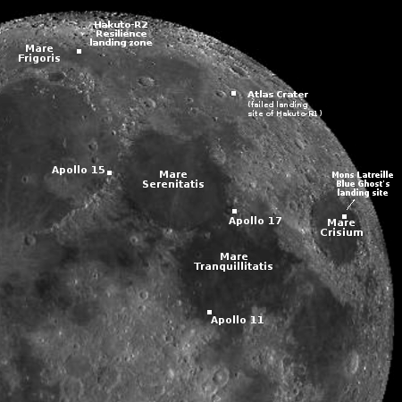
The prime payload was Firefly’s Blue Ghost lunar lander, flying ten science payloads to the Moon for NASA. It will take about six weeks to get to lunar orbit. The second payload was Resilience or Hakuto-R2, built by the Japanese startup Ispace on that company’s second attempt to land on the Moon. It is taking a longer route to the Moon, 4 to 5 months. The map to the right shows the landing locations for both landers. It also shows the first landing zone for Ispace’s first lander, Hakuto-R1, inside Atlas Crater. In that case the software misread the spacecraft’s altitude. It was still three kilometers above the ground when that software thought it was just off the surface and shut down its engines. The spacecraft thus crashed.
For context, the map also shows the landing sites of three Apollo missions.
Both spacecraft were correctly deployed into their planned orbits.
The first stage successfully completed its fifth flight, landing on a drone ship in the Atlantic.
The 2025 launch race:
8 SpaceX
2 China
Right now SpaceX’s launch pace exceeds once every two days. If it can even come close to maintaining that pace, it will easily match its goal of 180 launches in 2025.