A verde valley on Mars

A verde valley on Mars
Click for original image.

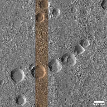
In the southwest where I live, a valley dubbed “verde” (which means “green” in Spanish) is generally a place with a somewhat persistent river with lots of lush plant life. The Verde Valley in Arizona is the perfect example, with “close to 80% of the valley’s land … national forest.”

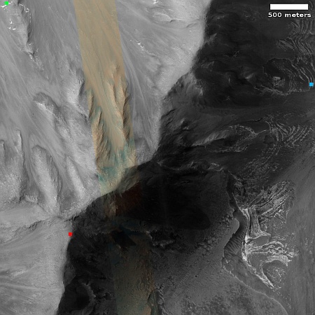
On Mars there is also a verde valley, but the name is not descriptive in the least. The picture to the right, rotated, cropped, and reduced to post here, was taken on January 22, 2023 by the high resolution camera on Mars Reconnaissance Orbiter (MRO) and shows one section of the Martian Verde Vallis, draining south to north.

The dark rippled patches inside this shallow canyon are sand dunes. In fact, though MRO has not taken many high resolution images of Verde Vallis, every one shows the valley with further patches of ripple dunes. See for example this image of a section of the valley just a bit farther north.
» Read more

Blobs and jellyfish in space

Blobs and Jellyfish
Click for original image.

Cool image time! The picture to the right, cropped and reduced to post here, was taken by the Hubble Space Telescope and released today.

The galaxy JW100 features prominently in this image from the NASA/ESA Hubble Space Telescope, with streams of star-forming gas dripping from the disc of the galaxy like streaks of fresh paint. These tendrils of bright gas are formed by a process called ram pressure stripping, and their resemblance to dangling tentacles has led astronomers to refer to JW100 as a ‘jellyfish’ galaxy. It is located in the constellation Pegasus, over 800 million light-years away.

Ram pressure stripping occurs when galaxies encounter the diffuse gas that pervades galaxy clusters. As galaxies plough through this tenuous gas it acts like a headwind, stripping gas and dust from the galaxy and creating the trailing streamers that prominently adorn JW100. The bright elliptical patches in the image are other galaxies in the cluster that hosts JW100.

The image was part of a research project studying star formation in the tendrils of jellyfish galaxies.

The blob near the top of the image is another galaxy in this same galaxy cluster. It is an elliptical galaxy that also happens to have two central nuclei, caused when two smaller galaxies merged. The central regions of each have not yet merged into one.

The ubiquitous presence of ice in the Martian mid-latitudes

Ice in the Martian mid-latitudes
Click for original image.

Cool image time! The picture to the right, rotated, cropped, rotated, and sharpened to post here, was taken on November 28, 2022 by the high resolution camera on Mars Reconnaissance Orbiter (MRO). Labeled merely as a “crater with mesa”, it gives us another example of the presence of glacial ice in the mid-latitudes of Mars.

That mesa is what planetary scientists have labeled “concentric crater fill,” a glacial feature found in numerous craters throughout the mid-latitude bands from 30 to 60 degrees latitude. The ground in the terrain surrounding the crater could be also be impregnated with ice, but based on the location as shown in the overview map below, it is just as likely to be lava.

In fact, the location of this particular crater illustrates why concentric crater fill might become the best source of ice for future colonists.
» Read more

Both India’s Chandrayaan-3 and Intuitive Machine’s Nova-C lunar landers pass vibration tests


Click for interactive map.

According to separate announcements just released, both India’s Chandrayaan-3 lander/rover and Intuitive Machine’s private Nova-C lunar lander have passed their last ground tests and are now ready for launch to the Moon later this year.

India’s space agency ISRO successfully completed testing of its Chandrayaan-3 lunar lander/rover in early March, completing vibration tests of the spacecraft and proving it will be able to survive the stresses during launch. The spacecraft successfully completed radiation testing in February.

ISRO is now targeting June 2023 for Chandrayaan-3’s launch.

Intuitive Machines meanwhile announced yesterday that its Nova-C lander has completed vibration testing, and is ready for launch later this year.

The map to the right shows the landing sites of these planned landers near the Moon’s south pole (indicated by the white cross), as well as Russia’s long-delayed lunar lander, Luna-25, which is now targeting a July launch.

Endless ripple dunes in Mars’ third largest impact basin

Ripple dunes in Mars' third biggest impact basin
Click for original image.

Cool image time! The picture to the right, cropped to post here, was taken on November 30, 2022 by the high resolution camera on Mars Reconnaissance Orbiter (MRO).

The section cropped shows only a small portion of the endless ripple dunes seen in this area. The color strip provides us some interesting other details as well as mysteries. The orange indicates dust on the ridges as well as the higher terrain near the center of the picture. The green in the hollows as well as to the east and west suggests coarser materials that have settled in lower elevations. This supposition is reinforced by the orange area near the bottom of the picture where the ripples have mostly dissipated. This is a high spot, and we appear to be looking at a dusty surface. (This impression is clearer in the full image.)

The latitude is high, 48 degrees south, but as far as I know orbital images have not found a lot of ice evidence in this part of Mars.
» Read more

Another study finds evidence of active volcanism on Venus

Changes in volcanic vent on Venus over eight months
Click for original image.

Using archival data from the Magellan spacecraft that orbited Venus in the early 1990s scientists think they have identified an active vent that appeared to change shape based on radar images taken eight months apart.

From the abstract of their paper:

We examine volcanic areas on Venus that were imaged two or three times by Magellan and identify a ~2.2 km2 volcanic vent that changed shape in the eight months between two radar images. Additional volcanic flows downhill from the vent are visible in the second epoch images, though we cannot rule out that they were present but invisible in the first epoch due to differences in imaging geometry. We interpret these results as ongoing volcanic activity on Venus.

This result is different that other research released last month that used Magellan data to identify geological features on Venus most likely to be active. In today’s results the scientists think they have spotted an actual volcanic eruption, as shown in the two images to the right. The image is taken from Figure 2 of the paper, with the changes in the center bottom vent clearly visible.

There is much uncertainty in these results that must be mentioned. The images are not optical but radar, so the scientists had to do a lot of computer processing to get the final result. They also compared this work with computer simulations to help confirm their conclusions.

The results also leave open the question of the total amount of volcanism presently active on Venus. As the scientists note in their conclusion, “With only one changed feature, we cannot determine how common currently active volcanism is on Venus.”

Nonetheless, the research using both new and archival data in the past thirty years is increasingly telling us that there is some active volcanism on Venus, hidden beneath its thick hellish cloudy atmosphere.

Reassessed fuel measurements give Mars Odyssey until 2025 before it runs out

Using more refined methods for measuring the fuel left on Mars Odyssey, the oldest orbiter circling Mars at this time, engineers have determined that it will not run out until 2025, not this year as previously thought.

Mars Odyssey has been in orbit around Mars since 2001. The fuel is used by thrusters to help maintain the spacecraft’s orientation, which is mostly done by reaction wheels, or gyroscopes. We should therefore not be surprised if by 2025 engineers figure out a way to get the reaction wheels to do the whole job, when the fuel runs out.

Geological evidence of past glacier found in Mars’ dry equatorial regions

Overview map

Scientists have uncovered geological evidence of a past glacier in westernmost end of the giant Martian canyon Valles Marineris, right at the point where it transitions into the complex chaos region dubbed Noctis Labyrinthus. The white dot on the map to the right indicates the location.

The surface feature identified as a “relict glacier” is one of many light-toned deposits (LTDs) found in the region. Typically, LTDs consist mainly of light-colored sulfate salts, but this deposit also shows many of the features of a glacier, including crevasse fields and moraine bands. The glacier is estimated to be 6 kilometers long and up to 4 kilometers wide, with a surface elevation ranging from +1.3 to +1.7 kilometers. This discovery suggests that Mars’ recent history may have been more watery than previously thought, which could have implications for understanding the planet’s habitability.

What we’ve found is not ice, but a salt deposit with the detailed morphologic features of a glacier. What we think happened here is that salt formed on top of a glacier while preserving the shape of the ice below, down to details like crevasse fields and moraine bands,” said Dr. Pascal Lee, a planetary scientist with the SETI Institute and the Mars Institute, and the lead author of the study. [emphasis mine]

You can read the paper here [pdf]. The research specifically suggests that near surface water ice in the dry equatorial regions of Mars could have been there much more recently that previously believed. It also suggests, by the rarity of this discovery, that there is likely almost no near surface ice in the equatorial regions, at present.

Perseverance captures a movie of Ingenuity’s 47th flight on Mars

Ingenuity shortly after take-off on its 47th flight
Click for full movie.

Overview map
Click for interactive map.

During Ingenuity’s 47th flight on Mars on March 9, 2023, one of Perseverance’s high resolution camera’s took rapid-fire images of the helicopter’s take-off and initial flight, from which the science team created a movie.

The overview map to the right provides the context for that movie at the link. The blue dot marks Perserverance’s location, with the yellow lines indicating the approximate area seen in the movie. The smaller green dot and line indicates Ingenuity’s take-off point and part of its flight seen in the movie, with the larger green dot its landing spot. From the press release:

This video shows the dust initially kicked up by the helicopter’s spinning rotors, as well as Ingenuity taking off, hovering, and beginning its 1,444-foot (440-meter) journey to the southwest.

At take-off Ingenuity was 394 feet away from Perseverance.

Firefly wins its second NASA contract to land payloads on the Moon

Capitalism in space: Firefly announced today that it has won a $112 million NASA contract to use its Blue Ghost lunar lander to bring three instruments to the Moon, one into orbit and two on the ground on the far side of the Moon.

Before landing on the Moon, the company’s Blue Ghost transfer vehicle will deploy the European Space Agency’s Lunar Pathfinder satellite into lunar orbit to provide communications for future spacecraft, robots, and human explorers. After touching down on the far side of the Moon, the Blue Ghost lunar lander will deliver and operate NASA’s S-Band User Terminal, ensuring uninterrupted communications for lunar exploration, and a research-focused payload that measures radio emissions to provide insight into the origins of the universe.

The NASA press release provides more details about the three payloads.

This is Firefly’s second NASA lunar lander contract. The first is scheduled to land in 2024 and deliver ten NASA science instruments to Mare Crisium, the large mare region in the eastern side of the Moon’s visible hemisphere. This second flight is tentatively scheduled to launch in 2026.

A Martian crater, ice, and dust devil tracks

A Martian crater, ice, and dust devil tracks
Click for original image.

Cool image time! The picture to the right, rotated, cropped, reduced, and sharpened to post here, was taken on January 2, 2023 by the high resolution camera on Mars Reconnaissance Orbiter (MRO). It is once again a terrain sample image, taken not for any specific research but to fill a gap in the schedule so as to maintain the camera’s proper temperature.

What this picture shows is that even though Mars has a thin atmosphere that produces dust devils, the propagation of dust devils is not uniform across the red planet’s surface. In this picture there are a lot of devil tracks, going in many different directions. Yet few of the many cool images I post from MRO show this number of tracks. In many cases the ground might not be agreeable to leaving tracks, but that cannot be the entire explanation.
» Read more

Potential Artemis-3 landing site on the Moon

The landing zone for the Artemis-3 mission to the Moon

Overview map

The panorama above was released today by the Lunar Reconnaissance Orbiter (LRO) science team, and shows one of the candidate landing sites (arrow) where Starship could land as part of the Artemis-3 mission to the Moon.

The map of the south pole to the right, created from LRO images and annotated by me, gives the context. The yellow lines indicate the approximate area covered by the panorama. The terrain here is rugged, to put it mildly. As the science team notes,

Imagine the view from the summit; it rises more than 5000 meters (16,400 feet) above its base. Off in the distance, you could see a 3500 meter (11,480 feet) tall cliff. One could argue that the sheer grandeur of this region makes it a prime candidate. But then again, a landing here might be too exciting?

That 11,480-foot-high cliff is the crater wall to the right of the arrow. Make sure you go to the link to view the original image. This will be a spectacular place to visit. Whether the astronauts however will be able to find out anything about ice in the shadowed crater floor thousands of feet below them remains questionable.

Artemis-3 is presently scheduled for 2025 but no one should be surprised if it is delayed.

Splats on Mars!

Splats on Mars
Click for original image.

Cool image time! The picture to the right, cropped and sharpened to post here, was taken on February 3, 2023 by the high resolution camera on Mars Reconnaissance Orbiter (MRO). It shows a number of crater splats of varying sizes. If you look at the full image, you will find several even bigger splats to the north of the one in the picture to the right. You will also see many more similar-sized crater splats to the south.

I cannot provide any confident explanation about what caused these splats, other than to assume that most here are secondary impacts from ejecta thrown out by a larger impact somewhere nearby. I also assume all these small impacts occurred at the same time because they all appear to have hit the ground when it had the same thick liquid consistency, a condition that was probably temporary. Note for example how many of the other craters in the full image do not have this same splattered look.
» Read more

Hubble looks at a nearby dwarf galaxy

A nearby dwarf galaxy
Click for original image.

Cool image time! The photo to the right, cropped, reduced, and sharpened to post here, was taken by the Hubble Space Telescope as part of a continuing project to capture high resolution images of every nearby galaxy, which in this particular case the caption describes as follows:

UGCA 307 hangs against an irregular backdrop of distant galaxies in this image from the NASA/ESA Hubble Space Telescope. The small galaxy consists of a diffuse band of stars containing red bubbles of gas that mark regions of recent star formation, and lies roughly 26 million light-years from Earth in the constellation Corvus. Appearing as just a small patch of stars, UGCA 307 is a diminutive dwarf galaxy without a defined structure — resembling nothing more than a hazy patch of passing cloud.

The red regions of star formation are significant, as they indicate that even in a tiny galaxy like this it is possible for there to be enough gas and dust to coalesce into new stars.

Astronomers living on a world inside this galaxy have an advantage over astronomers on Earth. There is no large galaxy like the Milky Way blocking their view of the cosmos in one direction. They can see it all, even in directions looking through UGCA 307.

Curiosity looks ahead: Which way to go?

Curiosity's view on March 11, 2023
Click for high resolution version. For original images, go here and here.

Overview map

How about a bonus weekend cool image! The panorama above, created from two pictures taken on March 11, 2023 by the right navigation camera on the Mars rover Curiosity, gives us a wonderful view of the alien Martian terrain that the rover is presently within. It also shows us the dilemma mission planners have in planning the rover’s future travels.

The red dotted line on both the panorama and the overview map to the right indicates the planned route. The yellow lines on the map indicates the approximate area viewed by the panorama. The blue dot marks Curiosity’s present position, where it is presently in the middle of a drilling campaign in the marker layer where it sits.

The plan had been to travel to the east of what I like to call the the hill of pillows (in the middle of the panorama). Yet, it appears from this navigation image that the terrain might be less difficult to the west. Both routes will get the rover to its goal in Gediz Vallis.

I have no idea what the mission planners will decide to do. I am just a tourist going along for the ride, and sharing the journey with my readers. This is the first time any human spacecraft has ever traveled through such mountainous terrain on any planet.

Ingenuity completes 47th flight, scouting ahead of Perseverance

Ingenuity sitting ahead of Perseverance, on the delta
Click for original image.

Overview map
Click for interactive map.

Though the science team has not, as of this posting, added the flight to Ingenuity’s flight log, according to the interactive map showing the positions of both Ingenuity and Perseverance on Mars, the helicopter completed its 47th flight yesterday as planned.

An annotated version of that map is to the right. The larger green dot marks Ingenuity’s new position. The smaller green dot marks its position when the panorama above was taken on February 27, 2023, capturing the helicopter in the distance (as indicated by the arrow). The yellow lines indicate the approximate area covered by that panorama. The blue dot marks Perseverance’s present position.

The flight’s planned distance was to go 1,410 feet to the southwest and “image science targets along the way.” As the helicopter also flew above Perseverance’s planned route, as indicated by the red dotted line, it also provided the rover team information about the ground Perseverance will travel along the way. Since the terrain here is generally not very rough, the information is not critical for route-picking. It might however spot some geological feature that bears a closer look that would not have been noticed by the rover alone.

Ice volcano in the Martian high northern latitudes?

Ice volcano on Mars
Click for original image.

That the Martian surface becomes increasingly icy as one approaches its poles is becoming increasingly evident from orbital images. Today’s cool image provides us another data point.

The picture to the right, rotated, cropped, reduced, and enhanced to post here, was taken on January 4, 2023 by the high resolution camera on Mars Reconnaissance Orbiter (MRO). It is once again another terrain sample image, taken not as part of any particular research project but to fill a gap in the camera’s schedule so as to maintain its temperature. With such pictures, it is hard to predict what will be seen, though the scientists try to find interesting things. In this case the camera team succeeded quite nicely, capturing what appears to me to be a small volcano with two calderas.

This volcano however has almost certainly not spouted lava but mud and water.
» Read more

Cracks in Martian lava

Cracks in Martian lava
Click for original image.

Cool image time! The picture to the right, rotated, cropped, and reduced to post here, was taken on January 25, 2023 by the high resolution camera on Mars Reconnaissance Orbiter (MRO). It was taken not as part of any specific research project, but to fill a gap in MRO’s picture-taking schedule in order to maintain the camera’s temperature. When such pictures need to be taken, the camera team tries to find something of interest in the area to be shot. Sometimes the picture is boring. Sometimes fascinating. Today’s picture I think falls into the latter category.

This is a lava flood plain, as shown in the overview map below. The meandering ridges are likely what geologists call lava dikes, places where lava was extruded out through a fissure. This suggests that the flat flood lava was an older crust, and that there was hot molten lava below it that eventually pushed its way up through cracks in that crust.

This hypothesis however is not certain, as the meandering nature of the ridges does not correspond well with what one would expect from such crustal cracks.
» Read more

Webb finds another galaxy in early universe that should not exist

The uncertainty of science: Scientists using the Webb Space Telescope have identified another galaxy about 12 billion light years away and only about 1.7 billion years after the theorized Big Bang that is too rich in chemicals as well as too active in star formation to have had time to form.

SPT0418-SE is believed to have already hosted multiple generations of stars, despite its young age. Both of the galaxies have a mature metallicity — or large amounts of elements like carbon, oxygen and nitrogen that are heavier than hydrogen and helium — which is similar to the sun. However, our sun is 4.5 billion years old and inherited most of its metals from previous generations of stars that were eight billion years old, the researchers said.

In other words, this galaxy somehow obtained complex elements in only 1.7 billion years that in our galaxy took twelve billion years, something that defies all theories of galactic and stellar evolution. Either the Big Bang did not happen when it did, or all theories about the growth and development of galaxies are wrong.

One could reasonably argue that this particular observation might be mistaken, except that it is not the only one from Webb that shows similar data. Webb’s infrared data is challenging the fundamentals of all cosmology, developed by theorists over the past half century.

Flat-topped mesas in the icy northern lowland plains of Mars

Flat-topped Martian craters
Click for full image.

Cool image time! The picture to the right, cropped and rotated to post here, was taken on December 27, 2022 by the high resolution camera on Mars Reconnaissance Orbiter (MRO), and shows what the scientists have labeled “flat topped hills in Utopia Planitia.”

Utopia Planitia is the largest impact basin on Mars, approximately 2,100 miles across and located in the northern lowland plains.

Orbital evidence strongly suggests it is a region with a lot of near surface ice. The picture to the right reinforces that conclusion, as the entire flat plain surrounding these buttes appears like an ice field. Moreover, the full image shows many craters filled with glacial features, most of which also have softened features, as if with time the ice that impregnates their material has sublimated away.
» Read more

Curiosity’s most recent cloud campaign

A cloud on Mars
Click for original image.

On January 30, 2023 I posted the picture to the right, taken by the high resolution camera on the Mars rover Curiosity. The picture was part of their ongoing cloud survey, running from January to March ’23 and using the rover’s hi-res camera to look for clouds during twilight. Today the rover science team issued a press release describing some of the results of that campaign. For example, on February 2nd the rover captured a sunset with sun rays, sunlight illuminating the bottom of clouds after the Sun has set. The release also provided this explanation for the cloud on the right.

In addition to the image of sun rays, Curiosity captured a set of colorful clouds shaped like a feather on Jan. 27. When illuminated by sunlight, certain types of clouds can create a rainbowlike display called iridescence. “Where we see iridescence, it means a cloud’s particle sizes are identical to their neighbors in each part of the cloud,” said Mark Lemmon, an atmospheric scientist with the Space Science Institute in Boulder, Colorado. “By looking at color transitions, we’re seeing particle size changing across the cloud. That tells us about the way the cloud is evolving and how its particles are changing size over time.”

In the case of Mars, the clouds are not made of liquid water droplets like on Earth, but ice particles, sometimes water and sometimes dry ice.

Newly discovered comet could be brightest object in sky in October ’24

Comet Tsuchinshan-ATLAS, discovered simultanuously by telescopes in China and South Africa, has the possibility of becoming brightest object in sky when it makes its closest approach to the Earth in October 2024.

As viewed from Earth, the comet may be as luminous as the brightest stars in the sky during its upcoming flyby, according to EarthSky. This is brighter than the green comet C/2022 E3 that just passed by Earth in January. That comet had a brightness of around magnitude +4.6, just visible to the naked eye. The new comet may have a brightness of magnitude 0.7, potentially peaking at magnitude -5, similar to Venus at its brightest.

The comet is presently between Jupiter and Saturn. Its 80,000 year long orbit will make its next close approach to the Sun on September 28, 2024.

Whether this will become a naked eye object of beauty of course remains totally uncertain. Its orbit, which appears stable but with rare swings past the Sun, suggests it will have lots of ice to sublimate into a bright tail. This also suggests the comet will survive this close approach without breaking up, since it has likely done this frequently in the past.

At the same time, the brightness of comets is unpredictable. We won’t really know how bright it will become until it is on it approach to the Sun, in the early fall of 2024.

IBEX leaves safe mode and returns to full science operations

Engineers have restored the orbiting astronomy probe IBEX out of safe mode, returning it to full science operations after a computer issue on February 18, 2023 that prevented the spacecraft from accepting commands.

To take the spacecraft out of a contingency mode it entered last month, the mission team performed a firecode reset (which is an external reset of the spacecraft) instead of waiting for the spacecraft to perform an autonomous reset and power cycle on March 4. The decision took advantage of a favorable communications environment around IBEX’s perigee – the point in the spacecraft’s orbit where it is closest to Earth.

After the firecode reset, command capability was restored. IBEX telemetry shows that the spacecraft is fully operational and functioning normally.

As I noted previously, IBEX was designed to study the boundary between the interstellar space and the solar system, and do it somehow from Earth orbit.

An inactive volcanic vent on Mars

An inactive volcanic vent on Mars
Click for full image.

Cool image time! The picture to the right, rotated, cropped, and reduced to post here, was taken on October 5, 2022 by the high resolution camera on Mars Reconnaissance Orbiter (MRO). Labeled by the science team as “Vents and Lava Flows on Flank of Pavonis Mons,” the section to the right shows the picture’s largest vent. The downhill grade is to the south.

In the full photo you can see that this vent sits on top of a flat mound of hardened lava, all of which flowed from the vent in the distant past. The main flow of course went to the south, out the channel and down the flanks of Pavonis Mons, the middle volcano in the line of three just to the west of Mars’ giant Valles Marineris canyon. The caldera peak of Pavonis Mons is about 35 miles away, and sits at a height of 47,000 feet elevation, far higher than Mount Everest but still only the fourth highest Martian volcano.

In the full picture, the entire surface also generally flows south, except for a crack that goes from northeast to southwest, possibly caused when the mountain flank sagged to the south.
» Read more

A confused spiral galaxy

An irregular spiral galaxy

Cool image time! The picture to the right, cropped and reduced to post here, was taken by the Hubble Space Telescope and released today. From the caption:

The irregular spiral galaxy NGC 5486 hangs against a background of dim, distant galaxies in this image from the NASA/ESA Hubble Space Telescope. The tenuous disc of the galaxy is threaded through with pink wisps of star formation, which stand out from the diffuse glow of the galaxy’s bright core. While this particular galaxy has indistinct, meandering spiral arms it lies close to the much larger Pinwheel Galaxy, one of the best known examples of ‘grand design’ spiral galaxies with prominent and well-defined spiral arms. In 2006 Hubble captured an image of the Pinwheel Galaxy which was — at the time — the largest and most detailed photo of a spiral galaxy ever taken with Hubble.

This galaxy is defined I think as an irregular spiral because if you look close, you can see a very faint hint of a central bar and two large arms spiraling away at its ends. It is faint however, and might simply be caused by the human mind’s natural desire to see patterns. To my eye this galaxy could just as well be a patchy elliptical galaxy, with no arms at all.

Juno captures close-up images of Jupiter’s moon Io

Io as seen by Juno

On March 1, 2023 the Jupiter orbiter Juno passed within 33,000 miles of the gas giant’s moon Io, getting its first close-up images.

Several citizen scientists have processed those images. The photo to the right, cropped and reduced to post here, was created by Andrew R Brown. This particular picture was one of five taken by Juno during the fly-by. Jason Perry processed all five here, with this caption:

Most of the dark spots seen across Io’s surface are the result of volcanic eruptions. These include East Girru, a dark spot that was not seen the last time Io was seen at this resolution during the New Horizons encounter with Jupiter in February 2007. East Girru was undergoing a major eruption at the time but hadn’t had time to produce a new lava flow before the end of the week-long encounter. This small flow field, measuring 3,200 square kilometers (1,390 square miles) in size, may have also been reactivated during an eruption in October 2021, as seen by Juno JIRAM.

Another apparent surface change is at Chors Patera, which has undergone a significant reddening since Galileo last observed it in October 2001. Reddish materials on Io are indicative of the presence of short-chain sulfur and are often associated with high-temperature, silicate volcanism. Additional dark spots near the terminator, the boundary between Io’s day and night sides, are the shadows of tall mountains. The dark spot at middle right in the upper right image may be due a mountain 5500 meters (18,000 feet) tall.

The smallest object resolved in this image is about 22 miles across.

Sightseeing in the region near the Starship Mars landing zone

Sightseeing in the region near Starship's landing zone
Click for original image.

Cool image time! The picture to the right, cropped and reduced to post here, was taken on November 30, 2022 by the high resolution camera on Mars Reconnaissance Orbiter (MRO). It shows a bulbous hill in the icy northern lowland plains of Mars. That it is icy here is indicated by the glacier features that appear to fill the small crater near the bottom of the picture.

You can get a better sense of stark alien nature of this terrain by looking at an MRO context camera image of the same area, taken on April 1, 2008. The subject hill is the first hill on the image’s west side, going from the top. This is a flat plain interspersed with crater splats, mounds of a variety of sizes, and a puzzling meandering dark line that suggests a crack from which material is oozing.

The geology to be studied here might be endless but for tourists the views will be astounding in their alienness.
» Read more

Sunspot update: After going through the roof last month, sunspots drop into the attic this month

With the start of another month NOAA this week updated its graph that tracks the number of sunspots on the Sun’s Earth-facing hemisphere. As I do every month, I have posted that updated graph below, adding some additional details to provide some context.

Last month the number of sunspots rocketed upward to the highest seen since 2014, and only the second time since November 2002 that the Sun was that active. In February those high numbers dropped, though the sunspot activity during the month remained well above the 2020 prediction by NOAA’s panel of solar scientists.

» Read more

Denial in the post-COVID era

For too many, it is too difficult to enter the Truth booth

The stream of new data about the failures of all the policies imposed on free Americans during the Wuhan panic has become so consistent and repetitive that, to a certain extent, I have become bored reporting it — especially because I have been reporting these facts over and over again since March 2020.

Nonetheless, it is important to do so. When the next new flu-type strain appears, and the power-hungry thugs that run our government try to fear-monger us all to gain power, it will help the general citizenry resist that fear-mongering by having more knowledge.

This essay is also partly inspired by my own doctor, Robert Lending, M.D., who since 2020 has been sending out periodic email updates on the state of the epidemic. From the beginning Lending tried to be as neutral as possible, avoiding any political battles or taking sides. He was not against lockdowns or mask mandates, but he also respected those that opposed them. Thus, he did not insist his patients where masks, especially when they had health reasons to not do so, unlike almost all other doctors. Nor did he ever require the jab to see his patients. His updates simply reported on the research and situation at the time, based on real data.

His most recent update, #107, however was different. It began with this blunt headline: “Should we start renaming COVID-19 to Pfizer-23?” and continued like so:
» Read more

1 34 35 36 37 38 271