Geotail mission finally ends after 30 years

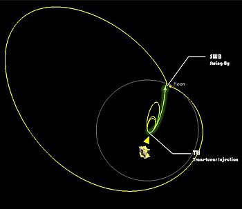
Though initially planned as a four year mission, the Geotail probe — designed to study the Earth’s magnetosphere — finally failed on June 28, 2022 after 30 years of operation.

With an elongated orbit, Geotail sailed through the invisible boundaries of the magnetosphere, gathering data on the physical process at play there to help understand how the flow of energy and particles from the Sun reach Earth. Geotail made many scientific breakthroughs, including helping scientists understand how quickly material from the Sun passes into the magnetosphere, the physical processes at play at the magnetosphere’s boundary, and identifying oxygen, silicon, sodium, and aluminum in the lunar atmosphere.

The mission also helped identify the location of a process called magnetic reconnection, which is a major conveyor of material and energy from the Sun into the magnetosphere and one of the instigators of the aurora. This discovery laid the way for the Magnetospheric Multiscale mission, or MMS, which launched in 2015.

Though it failed in June, engineers worked until November attempting to recover the spacecraft. When those efforts failed, NASA officially ended the mission.

The COVID jab: An emerging health disaster whose name cannot be spoken

Sudden collapse
One of many sudden collapses. Click for full video.

While from the beginning it appeared that the various COVID shots from different pharmaceutical companies were relatively safe to take, time is proving this assumption to be very false, with the data increasingly suggesting that the jab not only poses a significant, dangerous, and immediate health risk to young people, its long term effects on everyone who either chose to get it or was forced to by government mandate could very well be disastrous.

First the immediate risks. The numbers of individuals who have died suddenly and abruptly after getting the jab has been horrifying and shocking. Never in my life have I seen so many young and healthy people suddenly keeling over in public situations and dying. This story underlines the horror of the situation:

Such occurrences were unheard of prior to 2021. As noted at the link, “In fact, 500% more soccer players in the EU are dropping dead from heart attacks than just one year ago.” To capture the real horror of these events you need only watch the short video at this link. The thread that follows provides further documentation of this epidemic of “sudden death” and its apparent connection to the COVID shots.

Still, the actual medical link of these sudden heart failures to the COVID shots remains somewhat tentative, though more and more research is tying the two together.

From the last link:
» Read more

Curiosity climbs onto the Marker Band

Panorama as of January 17, 2023
Click for full image.

Overview map
Click for interactive map.

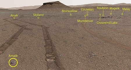
Curiosity’s exploration of the foothills of Mount Sharp continues. The panorama above, cropped, reduced, and annotated to post here, was taken on January 17, 2023 by the rover’s right navigation camera. It looks forward across the flat marker band terrain that the rover has been studying for the past few weeks.

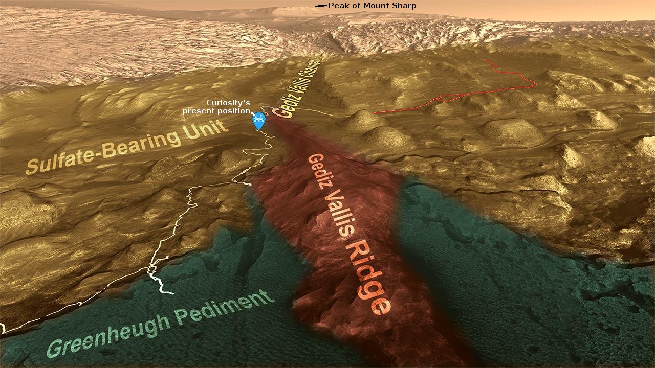
From orbit, this marker band appears very smooth and flat, and is found in many places on the flanks of Mount Sharp, always at about the same elevation. The arrows in the overview map to the right mark several places near Curiosity where the band is evident. The blue dot marks Curiosity’s present location, the red dotted line its planned route, and the yellow lines indicate the approximate area covered by the panorama above. The distance across the marker band to the uphill slope is about 500 feet.

Now that Curiosity is on the marker band, it no longer looks smooth. Instead, it is a flat plain of many uneven paving stones interspersed with dust. While not as rough as the Greenheugh Pediment, which Curiosity had to retreat from because it was too hard on the rover’s wheels, the marker band is hardly the smooth soft terrain implied by the orbital images.

These paving stones have also proven difficult to drill into, with Curiosity’s drill already failing twice previously because the rock was too hard. That hardness should not be a surprise, however, as this layer’s flatness in many places shows its resistance to erosion.

As it crosses this wide section of the marker band the science team will obviously be looking for more candidate drill sites. Sooner or later one should work.

The sea of dunes surrounding the Martian north pole

The sea of dunes surrounding the Martian north pole
Click for full image.

Cool image time! The photo to the right, rotated, cropped, and reduced to post here, was taken on December 5, 2022 by the high resolution camera on Mars Reconnaissance Orbiter (MRO). It shows a collection of wormlike dunes located in the giant sea of dunes that surrounds the Martian north pole ice cap.

North is to the top. The season when this picture was taken was northern winter. The Sun is barely above the horizon, only 8 degrees high, and shining from the southeast. Because it is winter it is also dust season, making the atmosphere hazy and thus making the light soft. No distinct shadows, except that the sides of the dunes facing away from the Sun are darkly shadowed.

The consistent orientation of the dunes suggests that the prevailing winds blow from the northeast to create the steep-sided alcoves. The wind however might not be the only factor to form these dunes.
» Read more

Hakuto-R completes five of ten milestones on test flight

Ispace’s private commercial lunar lander, Hakuto-R, has now completed five of the ten milestones the company had established before launch as its goals on this first test flight to the Moon.

The first five milestones completed are:

  • Completion of launch preparations
  • Completion of launch and deployment
  • Establishment of a Steady Operation Status
  • Completion of the first orbital control maneuver
  • Completion of stable deep-space flight operations for one month

The next five milestones involve entering final lunar orbit and landing successfully, the most difficult milestones of all.

A Martian river canyon?

A Martian river canyon?
Click for full image.

Today’s cool image highlights the biggest mystery of Mars that has baffled scientists since the first good pictures of its surface were taken in the early 1970s by the Mariner 9 orbiter. The picture to the right, rotated, cropped, reduced, and sharpened to post here, was taken on October 24, 2022 by the high resolution camera on Mars Reconnaissance Orbiter (MRO), and shows a very small segment of the 400-mile-long meandering canyon on Mars called Nigal Vallis. From the Wikipedia page:

The western half of Nirgal Vallis is a branched system, but the eastern half is a tightly sinuous, deeply entrenched valley. Nirgal Vallis ends at Uzboi Vallis. Tributaries are very short and end in steep-walled valley heads, often called “amphitheater-headed valleys.”

We can see one of those short tributaries on the image’s left edge. The overview maps below provide a wider view of this entire canyon.
» Read more

Russia delays three planned lunar probes because of sanctions

The research division that is building Russia’s Luna 26, Luna 27, and Luna 28 probes to the Moon announced today that these missions will likely be delayed up to two years because many needed components are no longer obtainable due to the international sanctions imposed on Russia because of its invasion of the Ukraine.

“Previously, we designed equipment using foreign components that we could buy from our foreign colleagues. Now that the sanctions have been imposed, we will [be switching to] Russian-made components,” Mitrofanov explained. According to him, researchers have to change design solutions amid the Western restrictions.

Some of these components cannot be so easily replaced by Russian versions. Assuming the Ukraine war does not end soon, expect even longer delays for these unmanned lunar missions.

Searching for surface changes caused by the biggest recorded Martian quake

Location of May quake
The white patches mark the locations on Mars of the largest quakes detected by InSight

On May 4, 2022, the seismometer on the InSight Mars lander detected a 4.7 magnitude earthquake on Mars, the largest ever detected.

The map to the right shows the approximate location of that quake by the white patch with the green dot. (You can read the paper describing this quake here [pdf].) This is also the same approximate location of a small five-mile-wide crater known to have many slope streaks on its interior walls.

Slope streaks are a uniquely Martian geological feature whose origin remains unknown. They resemble dark avalanche streaks flowing downhill, but make no changes in the topography, and lighten with time. They also occur randomly throughout the year. Two slightly different theories for their formation suggest that the streaks are triggered by the fall of dust particles, though neither is proven or even favored.

If either of these theories are true, then the 4.7 magnitude earthquake at this location should have caused the formation of more streaks. To find out, scientists have used the high resolution camera on Mars Reconnaissance Orbiter (MRO) to compare that crater both before and after the quake to see if any new streaks has appeared. Below is a side-by-side comparison of these images.
» Read more

Construction of the Thirty Meter Telescope in Hawaii remains in limbo

Despite the successful power grab by protesters that stopped construction and took management of the telescopes on Mauna Kea in Hawaii away from the University of Hawaii and gave it to a newly created board made up of “observatory representatives, Native Hawaiian cultural practitioners, local business and education officials, and experts in land management,” construction of the Thirty Meter Telescope (TMT) in Hawaii remains in limbo.

But there is another actor in this drama: the National Science Foundation (NSF). TMT has accrued substantial financial backing from its university backers and the governments of China, Japan, India, and Canada, but it is still far from fully funded and has asked NSF to fill the gap. TMT’s request has come in partnership with the Giant Magellan Telescope (GMT), another U.S.-led effort to build a massive new telescope. GMT’s site is already being prepared in Chile but it is also in financial straits.

Together, the two projects are seeking $3 billion from NSF in exchange for the wider U.S. astronomical community gaining access to a large slice of both scopes’ observing time. That proposal was judged by U.S. astronomers as their top priority for ground-based astronomy in the community’s decadal survey published in November 2021. NSF is now assessing whether this is a good investment for U.S. taxpayers.

Considering that Congress now believes that money grows on trees, and there is no reason not to fund anything anyone wants no matter how much debt it produces, I expect that the NSF will eventually fund both telescopes. There is however the slim possibility that the NSF will look at the new and very complex managerial make-up now running things in Hawaii and decide it is impractical and guaranteed to produce problems. The goals of the different members of this board are so contradictory that any construction on Mauna Kea will likely have to be renegotiated over and over again, causing further delays.

Of course, endless funding and delays could be considered a feature, not a bug, by our present corrupt federal government. In that case the NSF will celebrate these delays.

Racing above the clouds of Jupiter

Racing above the clouds of Jupiter
Click for full image.

Cool image time! The photo above, reduced in size to post here, was created from a raw Juno image by citizen scientist Kevin Gill. From his caption:

A low perspective over Jupiter’s North Polar Storms. Used imagery from the Juno spacecraft’s recent Perijove 47 to render a simulated view as if the viewer were only a few thousand kilometers above the clouds. Applied simulated altimetry, shadowing, and upper atmospheric transparency depth in Blender and Photoshop to render this.

To get some perspective on how large Jupiter is, the planet’s curve is about comparable to the same curve seen by astronauts of the Earth at a height of about 300 to 400 kilometers. In this image however we are about ten times higher.

First exoplanet confirmed by Webb

Astronomers have used for the first time the Webb Space Telescope to confirm the existence of an exoplanet, previous noted in data from the orbiting TESS telescope.

Formally classified as LHS 475 b, the planet is almost exactly the same size as our own, clocking in at 99% of Earth’s diameter. The research team is led by Kevin Stevenson and Jacob Lustig-Yaeger, both of the Johns Hopkins University Applied Physics Laboratory in Laurel, Maryland.

The team chose to observe this target with Webb after carefully reviewing targets of interest from NASA’s Transiting Exoplanet Survey Satellite (TESS), which hinted at the planet’s existence. Webb’s Near-Infrared Spectrograph (NIRSpec) captured the planet easily and clearly with only two transit observations.

The data is still preliminary, so more analysis is necessary to provide some information about the planet’s atmosphere.

American camera snaps picture of shadowed floor of Shackleton crater

floor of Shackleton Crater
Click for original image.

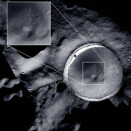
Using ShadowCam, a NASA-funded camera designed to take high resolution images of the permanently shadowed regions on the Moon, scientists have snapped the first picture of shadowed floor of Shackleton crater.

That image, reduced to post here, is to the right. I have added some labels to clarify what we are seeing. The arrow points to a boulder track caused when the boulder rolled down the crater rim slope.

The camera will be used to image the moon’s permanently shadowed regions with a resolution of better than 6.6 feet (2 meters) per pixel

ShadowCam is one of six instruments on the South Korean lunar orbiter, Danuri, which is now in lunar orbit and beginning its science phase. This was therefore only a successful test image to make sure the camera was working as planned.

Though the area photographed was in shadow (otherwise it would have saturated ShadowCam’s sensitive camera), this first image appears to show no ice at the base of the crater. This simply could be that this part of the crater floor is not permanently shadowed, but gets illuminated enough to melt off any ice. Or it could be that no ice exists in these places. We need to wait and see.

Astronomers discover more than 800 new supermassive black holes

Using archival data from both the orbiting Chandra X-Ray telescope and the ground-based Sloan Digital Sky Survey telescope (SDSS), astronomers have discovered more than 800 new supermassive black holes hidden in the center of galaxies.

By systematically combing through the deep Chandra Source Catalog and comparing to SDSS optical data, the researchers identified 817 XBONG candidates, more than ten times the number known before Chandra was in operation. Chandra’s sharp images, matching the quality of those from SDSS, and the large amount of data in the Chandra Source Catalog made it possible to detect this many XBONG candidates. Further study revealed that about half of these XBONGs represent a population of previously hidden black holes.

The key to this discovery is the use of telescopes observing in different wavelengths, X-rays with Chandra and optical with SDSS. Combined the data showed evidence of the hidden supermassive black holes.

A collapse on Mars

A collapse on Mars
Click for full image.

The photo to the right, cropped, reduced, and enhanced to post here, was taken on October 27, 2022 by the high resolution camera on Mars Reconnaissance Orbiter (MRO). The full photo was simply labeled as a “collapse feature”, and because it contained a few other sinks to the north beyond the top edge of this cropped picture, it is unclear if the scientists were referring to this sink in particular.

This sink is the most interesting however, because it really looks like something had sucked material out from below, causing the surface crust to fall downward, intact except for some cracks along the perimeter of the collapse.

The overview map below as always provides some context that might explain what we are seeing.
» Read more

A new hotspot map of Io, based on Juno data

Hot spot map of Io
Click for original figure.

Scientists have compiled a new map of the many volcanic hotspots on the Jupiter moon Io, based on data obtained by Juno, including 23 spots previously undetected. From the paper’s abstract:

We mapped the hot spot distribution on Io’s surface by analyzing the images acquired by the JIRAM instrument onboard the Juno spacecraft. We identified 242 hot spots, including 23 not present in other catalogs. A large number of the new hot spots identified are in the polar regions, specifically in the northern hemisphere. The comparison between our work and the most recent and updated catalog reveals that JIRAM detected 82% of the most powerful hot spots previously identified and half of the intermediate-power hot spots, thus showing that these are still active. JIRAM detected 16 out of the 34 faint hot spots previously reported.

The map above is taken from figure 2 of the paper. The data, when compared to other earlier data, confirms that many of these hot spots are long-lived, and have been erupting now for decades.

Ingenuity about to fly up onto the delta

Overview map
Click for interactive map.

The engineering team that operates the helicopter Ingenuity on Mars announced today that the next flight, #39, will go about 456 feet and travel to the northeast.

The green dot on the map to the right shows Ingenuity’s present location. The yellow lines indicate the territory within which this flight will head. If successful it will be the first time the helicopter has left the floor of Jezero Crater, and moved uphill onto the delta that flowed into that crater sometime in the far past.

The blue dot marks Perseverance’s present location. The dotted red line indicates its eventual planned route on that delta.

The engineers state that their flight goal is to “flight test new software”. This new software is supposed to allow Ingenuity to fly over rougher terrain. On the 38th flight, it proved its worth by not only flying over an area of rippled sand dunes, it landed between two.

This next flight, scheduled for sometime today, will be even more challenging, because the helicopter will have to fly upward above higher terrain.

TESS finds a second Earthsize planet orbiting in the habitable zone of a star

TESS solar system

The orbiting survey telescope TESS has discovered a second Earthsize planet in a solar system of four exoplanets.

The graphic to the right, a screen capture from a short video provided by the press release, shows these four exoplanets. Planet D had previously been discovered. Planet E is the new discovery, and is thought to be 95% Earth’s mass and likely terrestrial in make-up. Both are near the inner edge of the habitable zone.

TOI 700 is a small, cool M dwarf star located around 100 light-years away in the southern constellation Dorado. In 2020, Gilbert and others announced the discovery of the Earth-size, habitable-zone planet d, which is on a 37-day orbit, along with two other worlds.

The innermost planet, TOI 700 b, is about 90% Earth’s size and orbits the star every 10 days. TOI 700 c is over 2.5 times bigger than Earth and completes an orbit every 16 days. The planets are probably tidally locked, which means they spin only once per orbit such that one side always faces the star, just as one side of the Moon is always turned toward Earth.

This discovery only underlines the infinite possibilities and variables that exist for life on other worlds. These planets might be similar in mass to the Earth and get about the same heat/light energy from their sun, but the star is very different, their orbits are very different, and their environment is very different.

Starlink and National Science Foundation sign deal coordinating spectrum use

SpaceX and the National Science Foundation (NSF) today signed an agreement coordinating the use of radio spectrum so that Starlink satellites will not interfere with radio astronomy.

The National Science Foundation (NSF) and SpaceX have finalized a radio spectrum coordination agreement to limit interference from the company’s Starlink satellites to radio astronomy assets operating between 10.6 and 10.7 GHz. The agreement, detailed in a statement released by NSF today, ensures that Starlink satellite network plans will meet international radio astronomy protection standards, and protect NSF-funded radio astronomy facilities, including the National Radio Astronomy Observatory (NRAO) and the Green Bank Observatory (GBO).

This deal was part of a larger negotiation with the entire astronomy community to limit the problems caused to astronomy by the 3,000-plus Starlink satellites presently in orbit. These other actions include

…continuing to work to reduce the optical brightness of their satellites to 7th visual magnitude or fainter by physical design changes, attitude maneuvering, or other ideas to be developed; maintaining orbital elevations at ~700 km or lower; and providing orbital information publicly that astronomers can use for scheduling observations around satellite locations.

This agreement demonstrates again that SpaceX has tried hard to be a good citizen in this matter. It also illustrates once again that ground-based astronomical observations is becoming increasingly impractical. Astronomers have to go to space, and if Starship flies as SpaceX desires, the company will provide them a way to do it.

China’s Mars orbiter and rover in trouble

Yesterday we reported a tweet from Scott Tilley that suggested engineers were having trouble establishing a communications link with China’s Mars orbiter Tienwen-1.

Today it appears that communications with China’s rover Zhurong have also not resumed following its winter hibernation from May until December.

The Post independently confirmed with two sources on Thursday that the rover should have resumed running by now, but no contact has been established.

Though Zhurong’s solar panels can be tilted to kick dust from them, during hibernation this is apparently not possible. Because the winter dust season this year was especially bad (killing InSight for example), it is possible that Zhurong experienced the same fate.

Zhurong had a 90 day mission, and instead lasted a year. Moreover, tt was never expected to survive a Martian winter. The achievement thus remains grand.

As for the Tienwen-1 orbiter, it would be a much bigger failure if communications cannot be re-established. China without question expected this orbiter to operate for years, even functioning as a communications link for later landers/rovers. Its loss will force a revision of later plans.

Defrosting Martian Dunes

Defrosting Martian dunes
Click for full image.

Cool image time! The photo to the right, cropped, reduced, and sharpened to post here, was a captioned image on January 6, 2023 from the science team of the high resolution camera on Mars Reconnaissance Orbiter (MRO). From the caption by Alfred McEwen of the Lunar & Planetary Laboratory in Arizona:

In the late winter when first illuminated, the carbon dioxide frost at high latitudes will begin to sublimate. Over sand dunes, the defrosting spots and mass wasting on steep slopes produce striking patterns. This scene is especially artistic given the shapes of the dunes as well as the defrosting patterns.

» Read more

Webb finds “wide diversity of galaxies in the early universe”

Webb galaxies in the early universe
Click for full image.

New data from the Webb Space Telescope and presented this week at an astronomy conference has found that galaxies in the early universe exhibit much of the same range of shapes and morphologies seen in the recent universe, a result that was not expected.

The image to the right comes from the press release. You can read the research paper here [pdf].

The study examined 850 galaxies at redshifts of z three through nine, or as they were roughly 11-13 billion years ago. Associate Professor Jeyhan Kartaltepe from Rochester Institute of Technology’s School of Physics and Astronomy said that JWST’s ability to see faint high redshift galaxies in sharper detail than Hubble allowed the team of researchers to resolve more features and see a wide mix of galaxies, including many with mature features such as disks and spheroidal components.

“There have been previous studies emphasizing that we see a lot of galaxies with disks at high redshift, which is true, but in this study we also see a lot of galaxies with other structures, such as spheroids and irregular shapes, as we do at lower redshifts,” said Kartaltepe, lead author on the paper and CEERS co-investigator. “This means that even at these high redshifts, galaxies were already fairly evolved and had a wide range of structures.”

The results of the study, which have been posted to ArXiv and accepted for publication in The Astrophysical Journal, demonstrate JWST’s advances in depth, resolution, and wavelength coverage compared to Hubble. Out of the 850 galaxies used in the study that were previously identified by Hubble, 488 were reclassified with different morphologies after being shown in more detail with JWST. Kartaltepe said scientists are just beginning to reap the benefits of JWST’s impressive capabilities and are excited by what forthcoming data will reveal.

“This tells us that we don’t yet know when the earliest galaxy structures formed,” said Kartaltepe. “We’re not yet seeing the very first galaxies with disks. We’ll have to examine a lot more galaxies at even higher redshifts to really quantify at what point in time features like disks were able to form.”

In other words, it appears galaxies of all shapes, as we see them today, already existed 11-13 billion years ago, shortly after the universe was born. This defies most theories about the formation of the universe, which predict that these early galaxies would be different than today’s.

The data however at this point is sparse. Webb has only begun this work, and as Kartaltepe notes, they need to look a lot more galaxies.

Steady decline for decades in the publication of “disruptive science”

The steady decline in the publication of disruptive science

Though their definition of what makes a science paper disruptive is open to debate, a review of millions of peer-reviewed papers published since the end of World War II has shown a steady decline in such papers, as if scientists are increasingly unwilling or unable to think outside the box.

The graph to the right comes from this research.

The authors reasoned that if a study was highly disruptive, subsequent research would be less likely to cite the study’s references, and instead cite the study itself. Using the citation data from 45 million manuscripts and 3.9 million patents, the researchers calculated a measure of disruptiveness, called the ‘CD index’, in which values ranged from –1 for the least disruptive work to 1 for the most disruptive.

The average CD index declined by more than 90% between 1945 and 2010 for research manuscripts, and by more than 78% from 1980 to 2010 for patents. Disruptiveness declined in all of the analysed research fields and patent types, even when factoring in potential differences in factors such as citation practices.

The authors also analysed the most common verbs used in manuscripts and found that whereas research in the 1950s was more likely to use words evoking creation or discovery such as ‘produce’ or ‘determine’, that done in the 2010s was more likely to refer to incremental progress, using terms such as ‘improve’ or ‘enhance’.

The article that I link to above is from Nature, so of course it can’t see the elephant in the room, citing as a possible explanation “changes in the scientific enterprise” where most scientists today work as teams rather than alone.

I say, when you increasingly have big government money involved in research, following World War II, it becomes more and more difficult to buck the popular trends. Tie that to the growing blacklist culture that now destroys the career of any scientist who dares to say something even slightly different, and no one should be surprised originality is declining in scientific research. The culture will no longer tolerate it. You will tow the line, or you will be gone. Scientists are thus towing the line.

To my readers: I had intended to include this paper as part of a larger essay about the general blacklist culture that now dominates American society, but my continuing health issues make it difficult to sit at my desk for long periods. I hope to have things under control in the next few days, but until then my posting is going to continue to be limited.

Two nearby galactic neighbors

Two nearby galactic neighbors
Click for full image.

Cool image time! The photo to the right, cropped, reduced, and sharpened to post here, was taken by the Hubble Space Telescope of two nearby galaxy neighbors to the Milky way.

This image from the NASA/ESA Hubble Space Telescope features the galaxy LEDA 48062 in the constellation Perseus. LEDA 48062 is the faint, sparse, amorphous galaxy on the right side of this image, and it is accompanied by a more sharply defined neighbour on the left, the large, disc-like lenticular galaxy UGC 8603. A smattering of more distant galaxies also litter the background, and a handful of foreground stars are also visible throughout the image.

LEDA 48062 is estimated to be approximately 30 million light years away. This image was part of a recent Hubble campaign to study every known galaxy within 33 million light years.

Assuming that UGC 8603 is about the same approximate distance, the utter dissimilarity between these two galaxies is quite mystifying. It is also possible that UGC 8603 is larger and much farther away.

The dry and dusty equatorial regions of Mars

The dry cratered highlands of Mars
Click for full image.

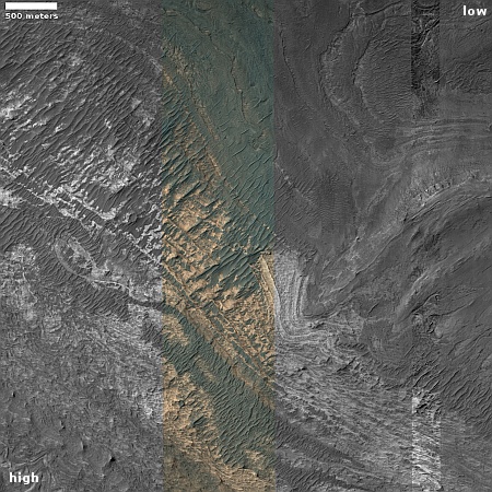
Cool image time! The photo to the right, rotated, cropped, and reduced to post here, was taken on October 2, 2022 by the high resolution camera on Mars Reconnaissance Orbiter (MRO). It shows a cluster of craters filled with ripple dunes.

The color strip tells us something [pdf] about the surface materials here. The reddish-orange in the craters is thought to be dust. The greenish terrain above the craters is likely coarse rock or bedrock, covered with a veneer of dust.

There is no ice here, just dust that over time has become trapped in the craters and cannot escape. And though there is also dust on the surrounding terrain, there is not that much. The craters themselves are likely very ancient, based on their shape and the eroded condition of their rims.

» Read more

Drainage out of a Martian crater

Drainage out of a Martian crater
Click for full image.

Today’s cool image to the right, rotated, cropped, reduced, and sharpened to post here, not only gives us another example of a Martian geological feature that is unique to Mars and whose origins are not yet understood, it also shows what appears to have once been a lake-filled crater that over time drained out to the east through a gap.

This picture was taken on October 14, 2022 by the high resolution camera on Mars Reconnaissance Orbiter (MRO). The inexplicable geology is called brain terrain, and it fills the floor of the crater on the picture’s left side. The rim shows a gap, from which a meandering channel continues downhill to the east. The lake inside the crater might not have been liquid water, but ice. The channel might not have been formed by flowing water, but by a glacial flow downhill.

What makes this glacial evidence especially interesting is that it is located in a very different part of the Martian mid-latitudes.
» Read more

China releases first update on status of Yutu-2 since September

Yutu-2's travel path through December 2022
Click for full image. The red flag marks the landing site.

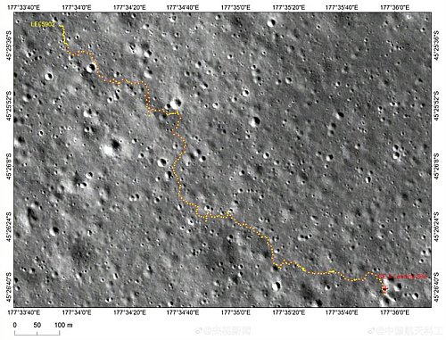
China today released its first update since September on the status of its Yutu-2 rover on the far side of the Moon. The map on the right shows the rover’s travels through December 2022.

As of today the rover has traveled 4,774 feet total, and about 450 feet since September. The goal, as stated in April 2021, was to “move northwest toward the basalt distribution area located about 1.2 km away.” At the time the rover was only averaging about 100 feet travel per lunar day. According to these numbers, it picked up the pace in the past year, though it is unclear whether it has reached that goal.

The soft icy Martian northern lowland plains

The soft icy Martian northern lowland plains
Click for full image.

In a cool image post last week, I noted that the near surface “ice sheets in the northern lowland plains are never … smooth, even if well protected.” The picture to the right, cropped, reduced, and sharpened to post here, provides an excellent example. It was taken on November 2, 2022 by the high resolution camera on Mars Reconnaissance Orbiter (MRO).

It is winter, and the sunlight is coming from the southwest, only 27 degrees above the horizon. The mound on the left is soft, while the depression on the upper right appears to have sand dune ripples sitting on top of a flat glacial mound. This depression may be an eroded crater (no upraised rim) or it could be a sink caused by the sublimation of the near surface ice.

Everywhere else the flat plains are stippled with small knobs.

The overview map below provides more context.
» Read more

Largest volcanic eruption in years detected on Io

Using instruments on a ground-based telescope, one scientist based at the Planetary Science Institute (PSI) in Arizona has detected the largest volcanic eruption in years on the Jupiter moon Io.

PSI Senior Scientist [Jeff] Morgenthaler has been using IoIO, located near Benson, Arizona to monitor volcanic activity on Io, since 2017. The observations show some sort of outburst nearly every year, but the largest yet was seen in the fall of 2022. Io is the innermost of Jupiter’s four large moons and is the most volcanic body in the Solar System thanks to the tidal stresses it feels from Jupiter and two of its other large satellites, Europa and Ganymede.

IoIO uses a coronagraphic technique which dims the light coming from Jupiter to enable imaging of faint gases near the very bright planet. A brightening of two of these gases, sodium and ionized sulfur, began between July and September 2022 and lasted until December 2022. The ionized sulfur, which forms a donut-like structure that encircles Jupiter and is called the Io plasma torus, was curiously not nearly as bright in this outburst as previously seen. “This could be telling us something about the composition of the volcanic activity that produced the outburst or it could be telling us that the torus is more efficient at ridding itself of material when more material is thrown into it,” Morgenthaler said.

The material released by this eruption could impact Juno during future close approaches of Jupiter.

Sunspot update: The most sunspots since 2014

Time for my monthly sunspot update, based on NOAA’s monthly graph that tracks the number of sunspots on the Sun’s Earth-facing hemisphere. The newest graph, with December’s numbers added to the timeline, is below. As always, I have added some additional details to provide context.

In December the half-year pause in the ramp up to solar maximum ceased, with the Sun seeing the most sunspots since September 2014. This high activity far exceeded the predicted sunspot count for December 2023, almost doubling it. In fact, December’s sunspot count almost equaled the predicted peak for the upcoming solar maximum, which is not supposed to happen until sometime in 2025.

» Read more

A spray of Martian hollows

A spray of Martian sinks
Click for full image.

Cool image time! The photo to the right, rotated, cropped, reduced, and sharpened to post here, was taken on October 12. 2022 by the high resolution camera on Mars Reconnaissance Orbiter (MRO). Dubbed simply as a a “terrain sample” by the science team, the picture was not taken as part of any specific research project, but instead to fill a gap in the orbiter’s shooting schedule so as to maintain the camera’s proper temperature. When MRO’s science team does this, they try to pick something in the area below that might be interesting. Sometimes they succeed, but often the features in the picture are nondescript.

The white line delineates the rim of a faint and very eroded small crater. Are the depressions that are mostly concentrated just to its south and east sinks or past impact craters? I haven’t the faintest idea. The overview map below helps to answer this question, but only partly.
» Read more

1 38 39 40 41 42 271