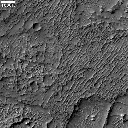
The edge of the Martian south pole ice cap

The edge of the Martian south pole ice cap
Click for full image.

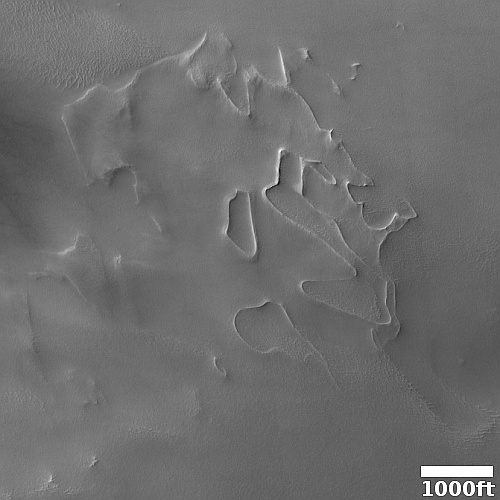
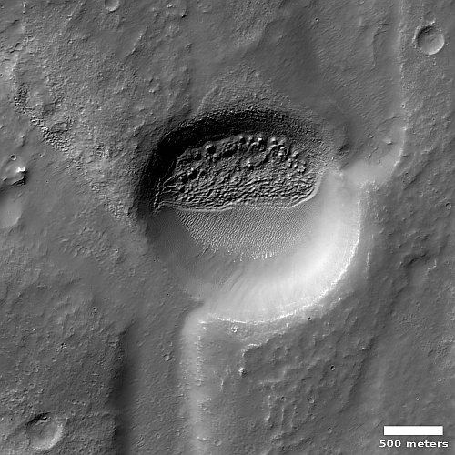
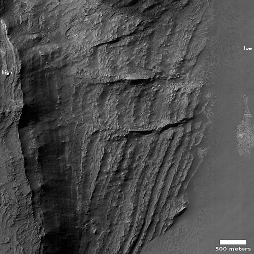
Cool image time! The photo to the right, rotated, cropped, reduced, and sharpened to post here, was taken on September 4, 2022 by the high resolution camera on Mars Reconnaissance Orbiter (MRO). The MRO science team labeled this simply “Diverse Terrain,” an apt description but woefully incomplete.

Though the grade here goes uphill to the south, there are ups and downs along the way. The flat areas near the top as well that band near the bottom appear to be the oldest terrain, with the rough hollows appearing to be places where that flat material has sublimated or eroded away.

This terrain is in the very high southern latitudes. South is to the bottom of this picture, with the south pole of Mars about 380 miles away. Thus, that eroding top layer is likely disappearing because it has either water ice or dry ice within it, and over time it sublimates away.

The picture itself was taken in winter, when the entire surface is likely covered with a thin mantle of dry ice that fell as snow with the coming of colder temperatures. A wider view of this region in the spring, taken by MRO’s context camera, shows that this mantle, now appearing like white frost, appears largely confined to the higher terrain. Apparently, the annual sublimation of this dry ice mantle is linked somehow to the erosion of this flat terrain.

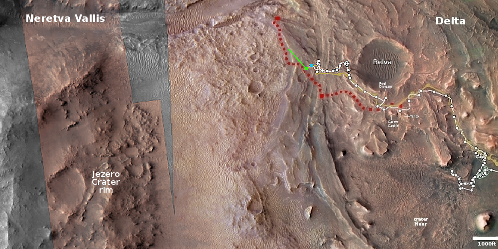
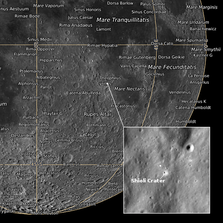
The additional location information provided by overview map below helps explain why this terrain is so diverse.
» Read more

A barred spiral galaxy with distorted galaxy

A barred spiral galaxy
Click for full image.

Cool image time! The photo to the right, reduced and cropped to post here, was taken by the Hubble Space Telescope and shows a barred spiral galaxy about 214 million light years away.

Scientists used NASA’s Hubble Space Telescope to image NGC 6956 to study its Cepheid variable stars, which are stars that brighten and dim at regular periods. Since the period of Cepheid variable stars is a function of their brightness, scientists can measure how bright these stars appear from Earth and compare it to their actual brightness to calculate their distance. As a result, these stars are extremely useful in determining the distance of cosmic objects, which is one of the hardest pieces of information to measure for extragalactic objects.

The press release of course focuses on this magnificent barred spiral. I however want to draw your attention to the smaller galaxy in the white box.

background distorted galaxy

Since we do not know the distance to this distorted galaxy, we do not know if its distortion is caused by the barred spiral. It could be the bigger galaxy’s gravity is pulling material away.

More likely, based on the shape of this smaller galaxy, is that it is many light years farther away — which is why it looks so much smaller — and has been distorted because it is actually a collusion of two galaxies. The two bright nuclei with the red dust between strongly suggests such a collusion.

I highlight this background galaxy because it illustrates the importance when looking at any Hubble image to look at everything. To coin a phrase, there is gold in them thar hills, if you make the effort to look.

NASA loses contact with one hurricane satellite in constellation of eight

NASA has lost contact with one of the eight CYGNSS satellites it uses to track and measure hurricanes worldwide.

The remaining seven satellites that comprise the CYGNSS constellation remain operational and have continued collecting scientific data since FM06 went incommunicado last month, according to NASA’s primary statement about the incident. The constellation’s science work can continue without FM06, but if the team can’t reconnect with the spacecraft, the loss will reduce the spatial coverage of CYGNSS, which until November provided nearly gap-free coverage of Earth.

At the moment engineers do not know why contact was lost, or if they can regain it.

Astronomers determine that two super-Earths are not as rocky as previously believed

Using observations from both the Hubble Space Telescope and the now retired Spitzer infrared space telescope, astronomers now think that two super-Earth-sized explanets are not as rocky as previously believed, and are in fact liquid worlds with as much as half their make-up comprised of water. From the press release:

Water wasn’t directly detected at Kepler-138 c and d, but by comparing the sizes and masses of the planets to models, astronomers conclude that a significant fraction of their volume – up to half of it – should be made of materials that are lighter than rock but heavier than hydrogen or helium (which constitute the bulk of gas giant planets like Jupiter). The most common of these candidate materials is water.

“We previously thought that planets that were a bit larger than Earth were big balls of metal and rock, like scaled-up versions of Earth, and that’s why we called them super-Earths,” explained Björn Benneke, study co-author and professor of astrophysics at the University of Montreal. “However, we have now shown that these two planets, Kepler-138 c and d, are quite different in nature and that a big fraction of their entire volume is likely composed of water. It is the best evidence yet for water worlds, a type of planet that was theorized by astronomers to exist for a long time.”

With volumes more than three times that of Earth and masses twice as big, planets c and d have much lower densities than Earth. This is surprising because most of the planets just slightly bigger than Earth that have been studied in detail so far all seemed to be rocky worlds like ours. The closest comparison, say researchers, would be some of the icy moons in the outer solar system that are also largely composed of water surrounding a rocky core.

This data simply underlines a basic point: The information we have of all exoplanets is sparse, practically nil. Any conclusions about their make-up is an educated guess, at best. Even now the conclusion that these are water worlds should be treated with great skepticism.

Ingenuity completes 36th flight; preps for its 37th

Overview map
Click for interactive map.

Ingenuity on December 10, 2022 successfully completed 36th flight, flying about 180 feet to the northwest and then returning the same distance to land at its take-off point.

This was the third flight in a row to land at this point, and was also the third flight since the Mars helicopter’s software was upgraded to allow it to fly higher and over rougher terrain.

The green dot on the map to the right shows Ingenuity’s present position. The blue dot shows where Perseverance presently sits. The rover has been moving eastward, away from the cliff face to the west where it had gathered more core samples, including the first to contain surface regolith (that is, the dirt of Mars).

Engineers are already planning Ingenuity’s 37th flight, which is scheduled for tomorrow and will reposition the helicopter to a new landing spot.

More results from DART impact of Dimorphos

Didymos and Dimorphos as seen from Earth
Click for movie.

At a science conference this week scientists provided an update on the changes that occurred to the asteroid Dimorphos after it was impacted by the DART spacecraft in September, shortening its orbit around the larger asteroid Didymos by 33 minutes.

The image to the right is a screen capture from a short movie made from 30 images taken by the Magdalena Ridge Observatory in New Mexico, and part of a new image release of the asteroid pair.

It shows the motion of the Didymos system across the sky over the course of roughly 80 minutes, and features a long, linear tail stretching to the right from the asteroid system to the edge of the frame. The animation is roughly 32,000 kilometers across the field of view at the distance of Didymos.

According to the scientists, the impact displaced more than two million pounds of material from Dimorphos.

Observations before and after impact, reveal that Dimorphos and its larger parent asteroid, Didymos, have similar makeup and are composed of the same material – material that has been linked to ordinary chondrites, similar to the most common type of meteorite to impact the Earth. These measurements also took advantage of the ejecta from Dimorphos, which dominated the reflected light from the system in the days after impact. Even now, telescope images of the Didymos system show how solar radiation pressure has stretched the ejecta stream into a comet-like tail tens of thousands of miles in length.

Putting those pieces together, and assuming that Didymos and Dimorphos have the same densities, the team calculates that the momentum transferred when DART hit Dimorphos was roughly 3.6 times greater than if the asteroid had simply absorbed the spacecraft and produced no ejecta at all – indicating the ejecta contributed to moving the asteroid more than the spacecraft did.

This information is teaching us a great deal about these two particular asteroids, which could be used if for some reason their totally safe orbit got changed and they were going to impact Earth. However, NASA’s repeated effort to make believe this info would be useful for deflecting other asteroids is somewhat absurd. It is helpful, but each asteroid is unique. The data from DART is mostly helping astronomers get a better understanding of the geology of these specific asteroids, which will widen their understanding of asteroids in general. Planetary defense is really a very minor aspect of this work.

SpaceX launches oceanography satellite

SpaceX early this morning used its Falcon 9 rocket to successfully launch an oceanography satellite, dubbed SWOT, for both NASA and France’s space agency CNES.

The satellite it designed to measure the height of water on 90% of the Earth’s surface.

The first stage was making its sixth flight, and successfully returned to Earth, touching down on its landing pad at Vandenberg Space Force Base.

The leaders in the 2022 launch race:

59 China
57 SpaceX
21 Russia
9 Rocket Lab
8 ULA

The U.S. now leads China 81 to 59 in the national rankings, but trails the entire world combined 91 to 81.

These numbers however should change again later today, as SpaceX has another launch scheduled.

Perseverance records sound of dust devil

For the first time scientists have used the microphone on the Mars rover Perseverance to successfully record the sound of dust devil as it flowed overhead.

I have embedded a video of the recording below. The research paper can be read here.

Dust devils on Mars, while much less dense in its very thin atmosphere, are generally much larger than found on Earth.

The dust devil recently detected by Perseverance was 25 meters wide and 118 meters tall (82 feet by 387 feet), putting it squarely in the average zone in terms of size for Martian dust storms. But they can grow much bigger, too, as dust on Mars can be whipped up in huge global dust storms.

The data also picked up the sound of dust particles hitting the microphone, which will allow the scientists to measure the density of the devil.
» Read more

Curiosity looks down Gediz Vallis

Curiosity's looks down Gediz Vallis
Click for original image.

Overview map
Click for interactive map.

The panorama above was taken by Curiosity’s right navigation camera today, December 14, 2022, looking down into Gediz Vallis, the giant slot canyon that the rover will use as its route up Mount Sharp.

The red dotted lines above and on the overview map to the right indicate approximately the planned route for Curiosity. The yellow lines indicate the approximate area covered by the panorama above.

At present the scientists are attempting to drill into the marker band on which Curiosity sits. This marker layer is visible at many places at about the same elevation on all sides of Mount Sharp’s flanks. The white arrows indicate other examples of it in this overview map. It generally appears smooth and flat, which suggests it is made of a harder substance more resistant to erosion. That hardness was confirmed when Curiosity’s first drill attempt into it last week failed. The scientists are now trying again.

Juno snaps heat image of Jupiter’s volcano-covered moon Io

Io's volcanoes
Click for full image.

The image to the right, cropped and reduced to post here, was taken on July 5, 2022 by one of the infrared instruments on the Jupiter orbiter Juno of the moon Io, known for having many many active volcanoes.

This infrared image was derived from data collected by the Jovian Infrared Auroral Mapper (JIRAM) instrument aboard Juno. In this image, the brighter the color the higher the temperature recorded by JIRAM.

Each bright spot is an active volcano, some of which have been in the past photographed during eruptions. In fact, the first such photo was taken in March 1979 by the Voyager-1 spacecraft just after its fly-by of Jupiter, and was the first time any active volcano outside of Earth had ever been identified.

What made that discovery more profound was that only a week earlier scientists had published a paper predicting active volcanoes on Io, caused by the strong tidal forces from Jupiter’s gravity.

Since then planetary scientists have been studying Io’s volcanism repeatedly, tracking the evolution of specific volcanoes over time as they erupt and then become dormant.

Hakuto-R sends first image back to Earth

Hakuto-R's first released images
Go here and here for original images.

The private Hakuto-R lunar lander, owned and built by the Japanese-based company Ispace, is operating as planned and has sent back its first images from two different cameras.

The larger image to the right was taken by a camera on one of Canada’s payloads. It shows the Earth two minutes after launch, with the rocket’s upper stage acting as a frame. The inset, reduced to insert here, was taken 19 hours after launch by the lander’s main camera, and shows the Earth at night. Both images demonstrate that the spacecraft is stable and functioning perfectly.

The goals of the mission remain mostly engineering. Its focus is demonstrating first that Ispace’s lander can do what it says so that future customers will be confident buying payload space. Similarly, the payloads, such as the UAE’s Rashid rover, are doing the same thing.

The featureless volcanic ash plains of Mars

The featureless volcanic ash plains of Mars

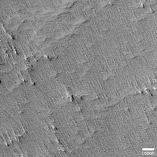
Cool image time! The photo to the right, cropped, reduced, and sharpened to post here, was taken on September 10, 2022 by the high resolution camera on Mars Reconnaissance Orbiter (MRO). It shows what appears to be a relatively featureless plain with a surface resembling stucco.

At -9 degrees south latitude, this is in the Martian dry equatorial regions. No ice or glaciers here. However, the consistent orientation of the knobs and hills suggest dunes and sand blown by prevailing winds, and that guess holds some truth. This location is deep within the Medusae Fossae Formation, the largest volcanic ash deposit on Mars, covering an area about as big as India, and believed to be the source of most of the red planet’s dust.

We are thus looking at thick layer of ash, its surface shaped over eons by the winds of Mars’ thin atmosphere.
» Read more

NASA approves $1.2 billion asteroid-hunting space telescope

NASA has given the go-ahead to build NEO-Surveyor for $1.2 billion, more than twice the cost of its original proposal, to launch by 2028 and then look for potentially dangerous asteroids.

Notably, NEO Surveyor was earlier estimated to cost between $500 million and $600 million, or around half of the new commitment. The NASA statement said that the cost and schedule commitments outlined align the mission with “program management best practices that account for potential technical risks and budgetary uncertainty beyond the development project’s control.” Earlier this year, the project’s launch was delayed two years, from 2026, due to agency budget concerns.

The mission is designed to discover 90% of potentially Earth-threatening asteroids and comets 460 feet (140 meters) or larger that come within 30 million miles (48 million kilometers) of Earth’s orbit. The spacecraft will carry out the survey while from Earth-sun Lagrange Point 1, a gravitationally stable spot in space about 930,000 miles (1.5 million kilometers) inside the Earth’s orbit around the sun.

A prediction: It will cost more, and not launch on time. NASA’s decision to double the budget and delay the launch two years suggests it did not trust the JPL cost and time estimates. Based on most NASA-centered projects, however, it is likely the new numbers will still be insufficient.

InSight still going, but barely

InSight's daily power levels as of December 12, 2022

The InSight science team issued another update today, outlining the continuing low power levels produced by the Mars lander, barely enough to keep its seismometer, and nothing else, running.

As of Dec. 12, 2022, InSight is generating an average of ~285 watt-hours of energy per Martian day, or sol. The tau, or level of dust cover in the atmosphere, was estimated at .96 (typical tau levels outside of dust season range from 0.6-0.7).

I have added these numbers to the graph at right in order to show their context over time. Since the October dust storm the levels have held steady, even as the dust in the atmosphere has cleared somewhat.

Nonetheless, InSight’s future continues to be day-to-day. Should it fail to respond to two consecutive scheduled communications sessions, the team will declare it dead, and make no effort at recovery. Though they have been expecting this to happen since the end of October, the lander continues to hang on.

NOAA once again over-predicts the hurricane count

As it has done repeatedly in recent years, NOAA in 2022 once again over-predicted the hurricane count for this past hurricane season, predicting an above-normal season when it actually ended up to be well below-normal.

In late May and again in early August 2022 NOAA predicted that the year 2022 Atlantic Hurricane Season (between June to end November calendar period) would be an “above normal” season with 14-21 named storms, between 6-10 hurricanes including 3-6 major hurricanes (Category 3,4 and 5) as shown in NOAA’s diagram below.

Colorado State University’s Department of Atmospheric Science/Tropical Meteorology Project has compiled the year 2022 tropical storm data, establishing that, compared to its 30 year North Atlantic data records covering the Climatological period 1991-2020, the year 2022 hurricane season was below average in Named Storms, Named Storm Days, Hurricane Days, Major Hurricanes, Major Hurricane Days and Accumulated Cyclone Energy (ACE).

The many graphs at the link also demonstrate that the predictions that there will be an increase in extreme weather events due to increased use of fossil fuels is also proving false.

A wall of smoke, as seen by Hubble

A wall of smoke, as seen by Hubble
Click for full image.

Using the Hubble Space Telescope, astronomers have produced a magnificent image of an interstellar cloud, cropped and reduced to post here. From the caption:

A portion of the open cluster NGC 6530 appears as a roiling wall of smoke studded with stars in this image from the NASA/ESA Hubble Space Telescope. NGC 6530 is a collection of several thousand stars lying around 4350 light-years from Earth in the constellation Sagittarius. The cluster is set within the larger Lagoon Nebula, a gigantic interstellar cloud of gas and dust. It is the nebula that gives this image its distinctly smokey appearance; clouds of interstellar gas and dust stretch from one side of this image to the other.

Astronomers investigated NGC 6530 using Hubble’s Advanced Camera for Surveys and Wide Field Planetary Camera 2. They scoured the region in the hope of finding new examples of proplyds, a particular class of illuminated protoplanetary discs surrounding newborn stars. The vast majority of proplyds have been found in only one region, the nearby Orion Nebula. This makes understanding their origin and lifetimes in other astronomical environments challenging.

The first proplyds were seen in the very first images taken by Hubble after it was fixed and could finally take sharp pictures. That so few have been seen since is thus somewhat surprising.

Remembering Apollo 17, fifty years after the last manned mission to the Moon

LRO oblique view of Apollo 17 landing site
Click for full image.

Link here.

The article comes from the Lunar Reconnaissance Orbiter (LRO) science team, and includes a number of LRO photos of the landing site, including the oblique annotated image to the right, reduced to post here. As the article notes:

The Apollo 17 crew was the last of an era in human space exploration and the last to set foot on the Moon. Fifty years later, the landing sites, hardware, and footsteps remain delicately preserved on the lunar surface. Join the LRO team as we commemorate their inspiring achievements with additional images, research, maps, interactive sites, and a dedicated video. LRO continues to image the Apollo sites whenever possible, under multiple lighting conditions, and combine these images into interactive sites, like the Apollo 17 Temporal Traverse. The Lunar QuickMap 3D tool can be used to preview the Apollo landing sites and search for LROC images of the areas. For downloadable maps of the Taurus-Littrow Valley, visit the Map Sheets section on our downloads page here. Finally, the Apollo 17 fiftieth anniversary video below presents highlights of the mission with landing site views reconstructed using LROC images and topography.

I have embedded that video below. It does a marvelous job summarizing this mission, which in many ways remains the most daring human exploration mission since Columbus dared cross an ocean in a tiny ship only slightly larger than many lifeboats.
» Read more

Update on the ten cubesats launched by SLS

Link here.

At this moment six of the ten cubesats either accomplished their mission successfully or are still operating, while four cubesats failed entirely.

Of those still working, two will go into lunar orbit and try to find evidence of both hydrogen and ice on the Moon. A third is testing “solid iodine” thrusters, while a fourth will observe how yeast samples react to a long exposure in deep space. A fifth cubesat is a joint NASA-JAXA mission, and is testing how to fly a smallsat in the low gravity of a Lagrangian point.

Finally, an Italian cubesat was used to successfully take images of the Moon and Orion, and has completed its mission.

SpaceX successfully launches Ispace’s Hakuto-R private mission to Moon

Lunar map showing Hakuto-R's landing spot
Hakuto-R’s planned landing site is in Atlas Crater.

Using its Falcon 9 rocket, SpaceX tonight successfully launched Ispace’s Hakuto-R lunar lander, the first private mission attempting to softly land on the Moon.

The Falcon 9 first stage completed its fifth flight, landing successfully at Cape Canaveral.

Hakuto-R, which is actually the first of two missions, carries seven payloads, including two small rovers, Rashid, which is the United Arab Emirates first lunar mission, and a smaller rover built by Ispace. Both will operate for about a week, one lunar day. Hakuto-R will land on the Moon in April, 2023.

A second payload is a cubesat from JPL, called Lunar Flashlight. It will go into lunar orbit, testing new fuel technologies while also attempting to identify water in the permanently shadowed craters at the lunar south pole.

The leaders in the 2022 launch race:

57 China
56 SpaceX
21 Russia
9 Rocket Lab
8 ULA

The U.S. now leads China 80 to 57 in the national rankings, but trails the entire world combined 87 to 80.

Ancient lava flows down the flanks of the solar system’s largest volcano

Lava flows on Olympus Mons
Click for full image.

Cool image time! The photo to the right, cropped, reduced, and sharpened to post here, was taken on October 2, 2022 by the high resolution camera on Mars Reconnaissance Orbiter (MRO). It shows what appears to be very old and eroded lava on the northeast flanks of Olympus Mons, the largest volcano on Mars as well as the entire solar system. About 600 miles across, from the edge to its peak, Olympus rises about 54,000 feet, with an actual height relative to Mars’ “sea level” of just under 70,000 feet, more than twice as high as Mount Everest on Earth.

The white arrow show the downward grade. Several different flows can be seen throughout the picture, some confined to a central channel with smooth aprons of overflows on either side. Others are more broken and less coherent, and suggest that either the flows were inherently different, or are much older and have deteriorated with time.
» Read more

Astronomers confirm Webb galaxies from the early universe

Astronomers using Webb have now confirmed with spectroscopy the age of at least four galaxies from the very very early universe, existing only a short time after the theorized Big Bang.

Four of the galaxies studied are particularly special, as they were revealed to be at an unprecedentedly early epoch. The results provided spectroscopic confirmation that these four galaxies lie at redshifts above 10, including two at redshift 13. This corresponds to a time when the universe was approximately 330 million years old, setting a new frontier in the search for far-flung galaxies. These galaxies are extremely faint because of their great distance from us.

The scientists had aimed Webb at Hubble’s Ultra Deep Field, doing a long infrared exposure lasting 28 hours over three days in order to gather the faintest infrared radiation (that Hubble could not see) and thus the most distant galaxies. The spectrum of individuals stars was then measured, which indicating their redshift and their estimated age.

The astronomers will next aim Webb at the more famous Hubble Deep Field, the first such long exposure that optical telescope took back in the late 1990s.

SOFIA to retire to Arizona museum

NASA yesterday announced that its airborne 747 SOFIA telescope will be retired to the Pima Air & Space Museum in Tucson, Arizona, making its final flight there December 13, 2022.

Pima, one of the world’s largest aerospace museums, is developing plans for when and how the SOFIA aircraft will eventually be on display to the public. Along with six hangars, 80 acres of outdoor display grounds, and more than 425 aircraft from around the world, Pima also has its own restoration facility where incoming aircraft like SOFIA are prepared for museum immortalization after their arrival.

While the idea of SOFIA, putting a astronomical telescope on an airplane to get it above most of the atmosphere, has some merit, this particular NASA project was always too costly and simply produced too little science to justify its expense.

In many ways, this museum display will provide one of the best ways to see a 747 itself, now also retired.

Astrobotic’s Peregrine lunar lander passes launch tests

Astrobotic’s first demonstration lunar lander, dubbed Peregrine, has passed its vibration and acoustic tests, demonstrating it can survive launch on ULA’s Vulcan rocket, presently scheduled for the first quarter of ’23.

The lander is now undergoing electromagnetic interference testing, which will be followed by thermal vacuum tests. Once those tests are complete, the company said, it will ship the lander to Cape Canaveral, Florida, to be integrated with the Vulcan Centaur for a launch currently scheduled in the first quarter of 2023. That launch will be the inaugural flight of the Vulcan Centaur.

A great deal will be riding on that first Vulcan launch, both for Astrobotic and ULA.

Webb’s infrared view of the Southern Ring Nebula

Two views of Southern Ring Nebula by Webb
Click for original image.

The two images to the left were produced by the Webb Space Telescope, showing in false colors the Southern Ring Nebula as seen by two of Webb’s infrared cameras.

The two images shown here each combine near-infrared and mid-infrared data to isolate different components of the nebula. The image at [top] highlights the very hot gas that surrounds the central stars. The image at [bottom] traces the star’s scattered molecular outflows that have reached farther into the cosmos.

Based on the data, astronomers posit that up the system could have as many as five stars orbiting each other, with three as yet unseen, or the inner ones might no longer exist, having been absorbed by the bigger stars.

It’s possible more than one star interacted with the dimmer of the two central stars, which appears red in this image, before it created this jaw-dropping planetary nebula. The first star that “danced” with the party’s host created a light show, sending out jets of material in opposite directions. Before retiring, it gave the dim star a cloak of dust. Now much smaller, the same dancer might have merged with the dying star – or is now hidden in its glare.

A third partygoer may have gotten close to the central star multiple times. That star stirred up the jets ejected by the first companion, which helped create the wavy shapes we see today at the edges of the gas and dust. Not to be left out, a fourth star with an orbit projected to be much wider, also contributed to the celebration. It circled the scene, further stirring up the gas and dust, and generating the enormous system of rings seen outside the nebula. The fifth star is the best known – it’s the bright white-blue star visible in the images that continues to orbit predictably and calmly.

Much of this remains mere theory, based on the available data. Nonetheless, the data from many such planetary nebula continues to suggest their strange and wonderful shapes are created by multiple stars, acting as a mix-master to churn up the nebula’s dust.

What a Martian impact looks like on a sheet of slushy ice

Overview map

What a Martian impact looks like on a sheet of ice
Click for full image.

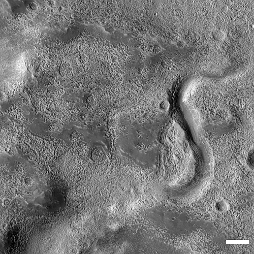
My headline is a bit of a guess, but it is an educated guess for today’s cool image. The photo to the right, cropped, reduced, and sharpened to post here, was taken on October 30, 2022 by the high resolution camera on Mars Reconnaissance Orbiter (MRO).

The location, as indicated by the white dot in the overview map above, puts this impact in a relatively flat area of Deuteronilus Mensae, the westernmost chaos region of the 2,000 mile long mid-latitude strip I call glacier country.

In other words, there is likely a lot of near surface ice here, as this impact makes very plain. If you imagine dropping a pebble into a thick layer of soft ice cream, you might get a crater reminiscent of this. I use for comparison ice cream on Earth because the lighter Martian gravity probably makes Martian ice softer and more slushy.

As I have said many times before, Mars is strange, Mars is mysterious, and above all Mars is alien.

New gamma ray burst violates the explanations of scientists

The uncertainty of science: A newly discovered long gamma ray burst (GRB) that appears to have been formed by the merger of two neutron stars has contradicted the long held views of scientists as to the origin of this particular type of GRB.

Prior to the discovery of this burst, astronomers mostly thought that there were just two ways to produce a GRB. The collapse of a massive star just before it explodes in a supernova could make a long gamma-ray burst, lasting more than two seconds. Or a pair of dense stellar corpses called neutron stars could collide, merge and form a new black hole, releasing a short gamma-ray burst of two seconds or less.

But there had been some outliers. A surprisingly short GRB in 2020 seemed to come from a massive star’s implosion (SN: 8/2/21). And some long-duration GRBs dating back to 2006 lacked a supernova after the fact, raising questions about their origins. “We always knew there was an overlap,” says astrophysicist Chryssa Kouveliotou of George Washington University in Washington, D.C., who wrote the 1993 paper that introduced the two GRB categories, but was not involved in the new work. “There were some outliers which we did not know how to interpret.”

There’s no such mystery about GRB 211211A: The burst lasted more than 50 seconds and was clearly accompanied by a kilonova, the characteristic glow of new elements being forged after a neutron star smashup.

Kouveliotou’s claim is not how I remember things back in 1990s. Then, the astronomers seemed certain that the two GRB classes were entirely separate, with no overlap, despite the large number of uncertainties.

A Martian ship’s prow

A Martian ship's prow
Click for full image.

Cool image time! The photo to the right, cropped, reduced, and sharpened to post here, was taken on August 31, 2022 by the high resolution camera on Mars Reconnaissance Orbiter (MRO). It shows what the scientists call “layering” surrounding this pointed mesa, which I roughly estimate to be somewhere between 200 to 400 feet high.

As you approach the mesa you first walk on the dust-covered flat plains. Then you start up a slope of what looks like alluvial fill, material that over time has fallen from the mesa to pile up as an apron at its base. You then reach a series of terraces, each likely marking a different layering major event from sometime in the distance past. Over time, for unknown reasons, the material surrounding this material has eroded away, while the mesa and its layers somehow survived.

The overview map below helps tell us what those past layering events were, as well as the source of the large amount of dust and sand at this location.
» Read more

Computer modelers predict millions will die if China relaxes its zero COVID lockdowns policy

Chicken Little rules again! Scientists, using the same kind of faulty computer models that falsely predicted millions would die in 2020 if we didn’t social distance, wear masks, and shut down all of society (while canceling the Bill of Rights), now predict millions will die in China if that country’s totalitarian communist government relaxes its zero COVID lockdowns policy.

A study based on vaccination rates in March, published in Nature Medicine in May, found that lifting zero-COVID restrictions at that point could “generate a tsunami of COVID-19 cases” over a 6-month period, with 112 million symptomatic cases, 2.7 million intensive care unit (ICU) admissions, and 1.6 million deaths. Peak demand for ICU beds would hit 1 million, more than 15 times the current capacity.

The unvaccinated would account for 77% of the fatalities, according to the authors, primarily at Fudan University. Boosting vaccination rates could slash the toll, but China’s elderly population has remained wary of vaccination. Even today, only 66% of those ages 80 and older have received two doses—versus 90% of the population as a whole—and just 40% have taken boosters.

We of course should trust these scientists without question. How could they possibly be wrong? Bless their hearts. They would never produce junk models simply to promote government overreach and abuse of power.

Ingenuity sets altitude record on 35th flight

Overview map
Click for interactive map.

On December 3, 2022 Ingenuity completed its 35th flight, traveling about 49 feet sideways but reaching a new altitude record for the Mars helicopter of 46 feet.

The map to the right shows the helicopter’s new position by the green dot, with Perseverance’s present position shown with the blue dot. The helicopter only moved slightly to the northwest of its previous position.

The plan had been to test the helicopter’s upgraded software at this new altitude while flying fly 50 feet sideways for 52 seconds at a speed of 6.7 feet per second. The flight met these goals almost exactly, going a distance only slightly shorter, well within its margin of error. The new altitude record however is significant, as going even slight distances higher in Mars’ very thin atmosphere (1/1000th of Earth’s) is challenging, to say the least. This higher flight means Ingenuity can fly up above higher terrain, such as the delta that is Perseverance’s next goal.

InSight’s low power levels holding steady

InSight's power levels as of November 29, 2022

The science team for the Mars’ lander InSight today (December 6th) released a new update (dated November 29th) of the power levels being produced by its dust-covered solar panels.

As of Nov. 29, 2022, InSight is generating an average between 290 watt-hours of energy per Martian day, or sol. The tau, or level of dust cover in the atmosphere, was estimated at .95 (typical tau levels outside of dust season range from 0.6-0.7).

I have added this new data unto the graph to the right, though I am puzzled by the date given to the update. Why post this today, when this update covers data only two days after the previous update (November 27th), and is more than a week out of date? This is especially puzzling because the numbers did not change at all.

Nonetheless, the lander is still alive, but barely. One wonders however what happened in the past week, since today’s update does not bring us up to date.

1 40 41 42 43 44 271