
First high resolution images released from Juice’s fly-by of the Earth & Moon

Click for original image.
The Italian science team that runs the high resolution camera on the asteroid probe Juice have now released that camera’s first images, taken to test its operation during the spacecraft’s close fly-by of both the Moon and then the Earth a week ago.
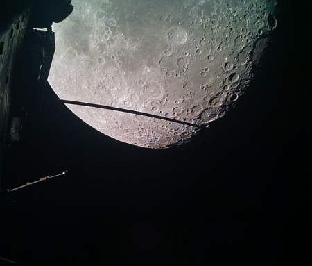
The picture to the right, cropped, reduced, and sharpened to post here, shows the Moon’s surface during that close fly-by, which got within 435 miles. The camera is dubbed Janus, and was developed by Italy and operated by the Italian National Institute for Astrophysics.
JANUS will study global, regional and local features and processes on the moons, as well as map the clouds of Jupiter. It will have a resolution up to 2.4 m per pixel on Ganymede and about 10 km per pixel at Jupiter.
The main aim of JANUS’s observations during the lunar-Earth flyby was to evaluate how well the instrument is performing, not to make scientific measurements. For this reason, JANUS took images with various camera settings and time intervals – a bit like if you’re going out to test a DSLR camera for the first time. In some cases, researchers intentionally ‘blurred’ the images so that they can test out resolution recovery algorithms. In other cases, they partially saturated the image to study the effects induced on the unsaturated areas.
As can be seen by the sample image above, the test images appear to have demonstrated that Janus will function as planned when Juice arrives in orbit around Jupiter in 2031 in order to study that gas giant’s upper atmosphere as well as its larger icy moons, Ganymede, Calisto, and Europa.


