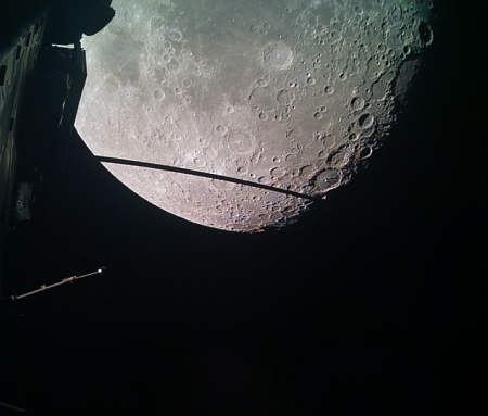
Potential Artemis-3 landing site on the Moon

The landing zone for the Artemis-3 mission to the Moon

Overview map

The panorama above was released today by the Lunar Reconnaissance Orbiter (LRO) science team, and shows one of the candidate landing sites (arrow) where Starship could land as part of the Artemis-3 mission to the Moon.

The map of the south pole to the right, created from LRO images and annotated by me, gives the context. The yellow lines indicate the approximate area covered by the panorama. The terrain here is rugged, to put it mildly. As the science team notes,

Imagine the view from the summit; it rises more than 5000 meters (16,400 feet) above its base. Off in the distance, you could see a 3500 meter (11,480 feet) tall cliff. One could argue that the sheer grandeur of this region makes it a prime candidate. But then again, a landing here might be too exciting?

That 11,480-foot-high cliff is the crater wall to the right of the arrow. Make sure you go to the link to view the original image. This will be a spectacular place to visit. Whether the astronauts however will be able to find out anything about ice in the shadowed crater floor thousands of feet below them remains questionable.

Artemis-3 is presently scheduled for 2025 but no one should be surprised if it is delayed.

Splats on Mars!

Splats on Mars
Click for original image.

Cool image time! The picture to the right, cropped and sharpened to post here, was taken on February 3, 2023 by the high resolution camera on Mars Reconnaissance Orbiter (MRO). It shows a number of crater splats of varying sizes. If you look at the full image, you will find several even bigger splats to the north of the one in the picture to the right. You will also see many more similar-sized crater splats to the south.

I cannot provide any confident explanation about what caused these splats, other than to assume that most here are secondary impacts from ejecta thrown out by a larger impact somewhere nearby. I also assume all these small impacts occurred at the same time because they all appear to have hit the ground when it had the same thick liquid consistency, a condition that was probably temporary. Note for example how many of the other craters in the full image do not have this same splattered look.
» Read more

Hubble looks at a nearby dwarf galaxy

A nearby dwarf galaxy
Click for original image.

Cool image time! The photo to the right, cropped, reduced, and sharpened to post here, was taken by the Hubble Space Telescope as part of a continuing project to capture high resolution images of every nearby galaxy, which in this particular case the caption describes as follows:

UGCA 307 hangs against an irregular backdrop of distant galaxies in this image from the NASA/ESA Hubble Space Telescope. The small galaxy consists of a diffuse band of stars containing red bubbles of gas that mark regions of recent star formation, and lies roughly 26 million light-years from Earth in the constellation Corvus. Appearing as just a small patch of stars, UGCA 307 is a diminutive dwarf galaxy without a defined structure — resembling nothing more than a hazy patch of passing cloud.

The red regions of star formation are significant, as they indicate that even in a tiny galaxy like this it is possible for there to be enough gas and dust to coalesce into new stars.

Astronomers living on a world inside this galaxy have an advantage over astronomers on Earth. There is no large galaxy like the Milky Way blocking their view of the cosmos in one direction. They can see it all, even in directions looking through UGCA 307.

Curiosity looks ahead: Which way to go?

Curiosity's view on March 11, 2023
Click for high resolution version. For original images, go here and here.

Overview map

How about a bonus weekend cool image! The panorama above, created from two pictures taken on March 11, 2023 by the right navigation camera on the Mars rover Curiosity, gives us a wonderful view of the alien Martian terrain that the rover is presently within. It also shows us the dilemma mission planners have in planning the rover’s future travels.

The red dotted line on both the panorama and the overview map to the right indicates the planned route. The yellow lines on the map indicates the approximate area viewed by the panorama. The blue dot marks Curiosity’s present position, where it is presently in the middle of a drilling campaign in the marker layer where it sits.

The plan had been to travel to the east of what I like to call the the hill of pillows (in the middle of the panorama). Yet, it appears from this navigation image that the terrain might be less difficult to the west. Both routes will get the rover to its goal in Gediz Vallis.

I have no idea what the mission planners will decide to do. I am just a tourist going along for the ride, and sharing the journey with my readers. This is the first time any human spacecraft has ever traveled through such mountainous terrain on any planet.

Ingenuity completes 47th flight, scouting ahead of Perseverance

Ingenuity sitting ahead of Perseverance, on the delta
Click for original image.

Overview map
Click for interactive map.

Though the science team has not, as of this posting, added the flight to Ingenuity’s flight log, according to the interactive map showing the positions of both Ingenuity and Perseverance on Mars, the helicopter completed its 47th flight yesterday as planned.

An annotated version of that map is to the right. The larger green dot marks Ingenuity’s new position. The smaller green dot marks its position when the panorama above was taken on February 27, 2023, capturing the helicopter in the distance (as indicated by the arrow). The yellow lines indicate the approximate area covered by that panorama. The blue dot marks Perseverance’s present position.

The flight’s planned distance was to go 1,410 feet to the southwest and “image science targets along the way.” As the helicopter also flew above Perseverance’s planned route, as indicated by the red dotted line, it also provided the rover team information about the ground Perseverance will travel along the way. Since the terrain here is generally not very rough, the information is not critical for route-picking. It might however spot some geological feature that bears a closer look that would not have been noticed by the rover alone.

Ice volcano in the Martian high northern latitudes?

Ice volcano on Mars
Click for original image.

That the Martian surface becomes increasingly icy as one approaches its poles is becoming increasingly evident from orbital images. Today’s cool image provides us another data point.

The picture to the right, rotated, cropped, reduced, and enhanced to post here, was taken on January 4, 2023 by the high resolution camera on Mars Reconnaissance Orbiter (MRO). It is once again another terrain sample image, taken not as part of any particular research project but to fill a gap in the camera’s schedule so as to maintain its temperature. With such pictures, it is hard to predict what will be seen, though the scientists try to find interesting things. In this case the camera team succeeded quite nicely, capturing what appears to me to be a small volcano with two calderas.

This volcano however has almost certainly not spouted lava but mud and water.
» Read more

Cracks in Martian lava

Cracks in Martian lava
Click for original image.

Cool image time! The picture to the right, rotated, cropped, and reduced to post here, was taken on January 25, 2023 by the high resolution camera on Mars Reconnaissance Orbiter (MRO). It was taken not as part of any specific research project, but to fill a gap in MRO’s picture-taking schedule in order to maintain the camera’s temperature. When such pictures need to be taken, the camera team tries to find something of interest in the area to be shot. Sometimes the picture is boring. Sometimes fascinating. Today’s picture I think falls into the latter category.

This is a lava flood plain, as shown in the overview map below. The meandering ridges are likely what geologists call lava dikes, places where lava was extruded out through a fissure. This suggests that the flat flood lava was an older crust, and that there was hot molten lava below it that eventually pushed its way up through cracks in that crust.

This hypothesis however is not certain, as the meandering nature of the ridges does not correspond well with what one would expect from such crustal cracks.
» Read more

Webb finds another galaxy in early universe that should not exist

The uncertainty of science: Scientists using the Webb Space Telescope have identified another galaxy about 12 billion light years away and only about 1.7 billion years after the theorized Big Bang that is too rich in chemicals as well as too active in star formation to have had time to form.

SPT0418-SE is believed to have already hosted multiple generations of stars, despite its young age. Both of the galaxies have a mature metallicity — or large amounts of elements like carbon, oxygen and nitrogen that are heavier than hydrogen and helium — which is similar to the sun. However, our sun is 4.5 billion years old and inherited most of its metals from previous generations of stars that were eight billion years old, the researchers said.

In other words, this galaxy somehow obtained complex elements in only 1.7 billion years that in our galaxy took twelve billion years, something that defies all theories of galactic and stellar evolution. Either the Big Bang did not happen when it did, or all theories about the growth and development of galaxies are wrong.

One could reasonably argue that this particular observation might be mistaken, except that it is not the only one from Webb that shows similar data. Webb’s infrared data is challenging the fundamentals of all cosmology, developed by theorists over the past half century.

Flat-topped mesas in the icy northern lowland plains of Mars

Flat-topped Martian craters
Click for full image.

Cool image time! The picture to the right, cropped and rotated to post here, was taken on December 27, 2022 by the high resolution camera on Mars Reconnaissance Orbiter (MRO), and shows what the scientists have labeled “flat topped hills in Utopia Planitia.”

Utopia Planitia is the largest impact basin on Mars, approximately 2,100 miles across and located in the northern lowland plains.

Orbital evidence strongly suggests it is a region with a lot of near surface ice. The picture to the right reinforces that conclusion, as the entire flat plain surrounding these buttes appears like an ice field. Moreover, the full image shows many craters filled with glacial features, most of which also have softened features, as if with time the ice that impregnates their material has sublimated away.
» Read more

Curiosity’s most recent cloud campaign

A cloud on Mars
Click for original image.

On January 30, 2023 I posted the picture to the right, taken by the high resolution camera on the Mars rover Curiosity. The picture was part of their ongoing cloud survey, running from January to March ’23 and using the rover’s hi-res camera to look for clouds during twilight. Today the rover science team issued a press release describing some of the results of that campaign. For example, on February 2nd the rover captured a sunset with sun rays, sunlight illuminating the bottom of clouds after the Sun has set. The release also provided this explanation for the cloud on the right.

In addition to the image of sun rays, Curiosity captured a set of colorful clouds shaped like a feather on Jan. 27. When illuminated by sunlight, certain types of clouds can create a rainbowlike display called iridescence. “Where we see iridescence, it means a cloud’s particle sizes are identical to their neighbors in each part of the cloud,” said Mark Lemmon, an atmospheric scientist with the Space Science Institute in Boulder, Colorado. “By looking at color transitions, we’re seeing particle size changing across the cloud. That tells us about the way the cloud is evolving and how its particles are changing size over time.”

In the case of Mars, the clouds are not made of liquid water droplets like on Earth, but ice particles, sometimes water and sometimes dry ice.

Newly discovered comet could be brightest object in sky in October ’24

Comet Tsuchinshan-ATLAS, discovered simultanuously by telescopes in China and South Africa, has the possibility of becoming brightest object in sky when it makes its closest approach to the Earth in October 2024.

As viewed from Earth, the comet may be as luminous as the brightest stars in the sky during its upcoming flyby, according to EarthSky. This is brighter than the green comet C/2022 E3 that just passed by Earth in January. That comet had a brightness of around magnitude +4.6, just visible to the naked eye. The new comet may have a brightness of magnitude 0.7, potentially peaking at magnitude -5, similar to Venus at its brightest.

The comet is presently between Jupiter and Saturn. Its 80,000 year long orbit will make its next close approach to the Sun on September 28, 2024.

Whether this will become a naked eye object of beauty of course remains totally uncertain. Its orbit, which appears stable but with rare swings past the Sun, suggests it will have lots of ice to sublimate into a bright tail. This also suggests the comet will survive this close approach without breaking up, since it has likely done this frequently in the past.

At the same time, the brightness of comets is unpredictable. We won’t really know how bright it will become until it is on it approach to the Sun, in the early fall of 2024.

IBEX leaves safe mode and returns to full science operations

Engineers have restored the orbiting astronomy probe IBEX out of safe mode, returning it to full science operations after a computer issue on February 18, 2023 that prevented the spacecraft from accepting commands.

To take the spacecraft out of a contingency mode it entered last month, the mission team performed a firecode reset (which is an external reset of the spacecraft) instead of waiting for the spacecraft to perform an autonomous reset and power cycle on March 4. The decision took advantage of a favorable communications environment around IBEX’s perigee – the point in the spacecraft’s orbit where it is closest to Earth.

After the firecode reset, command capability was restored. IBEX telemetry shows that the spacecraft is fully operational and functioning normally.

As I noted previously, IBEX was designed to study the boundary between the interstellar space and the solar system, and do it somehow from Earth orbit.

An inactive volcanic vent on Mars

An inactive volcanic vent on Mars
Click for full image.

Cool image time! The picture to the right, rotated, cropped, and reduced to post here, was taken on October 5, 2022 by the high resolution camera on Mars Reconnaissance Orbiter (MRO). Labeled by the science team as “Vents and Lava Flows on Flank of Pavonis Mons,” the section to the right shows the picture’s largest vent. The downhill grade is to the south.

In the full photo you can see that this vent sits on top of a flat mound of hardened lava, all of which flowed from the vent in the distant past. The main flow of course went to the south, out the channel and down the flanks of Pavonis Mons, the middle volcano in the line of three just to the west of Mars’ giant Valles Marineris canyon. The caldera peak of Pavonis Mons is about 35 miles away, and sits at a height of 47,000 feet elevation, far higher than Mount Everest but still only the fourth highest Martian volcano.

In the full picture, the entire surface also generally flows south, except for a crack that goes from northeast to southwest, possibly caused when the mountain flank sagged to the south.
» Read more

A confused spiral galaxy

An irregular spiral galaxy

Cool image time! The picture to the right, cropped and reduced to post here, was taken by the Hubble Space Telescope and released today. From the caption:

The irregular spiral galaxy NGC 5486 hangs against a background of dim, distant galaxies in this image from the NASA/ESA Hubble Space Telescope. The tenuous disc of the galaxy is threaded through with pink wisps of star formation, which stand out from the diffuse glow of the galaxy’s bright core. While this particular galaxy has indistinct, meandering spiral arms it lies close to the much larger Pinwheel Galaxy, one of the best known examples of ‘grand design’ spiral galaxies with prominent and well-defined spiral arms. In 2006 Hubble captured an image of the Pinwheel Galaxy which was — at the time — the largest and most detailed photo of a spiral galaxy ever taken with Hubble.

This galaxy is defined I think as an irregular spiral because if you look close, you can see a very faint hint of a central bar and two large arms spiraling away at its ends. It is faint however, and might simply be caused by the human mind’s natural desire to see patterns. To my eye this galaxy could just as well be a patchy elliptical galaxy, with no arms at all.

Juno captures close-up images of Jupiter’s moon Io

Io as seen by Juno

On March 1, 2023 the Jupiter orbiter Juno passed within 33,000 miles of the gas giant’s moon Io, getting its first close-up images.

Several citizen scientists have processed those images. The photo to the right, cropped and reduced to post here, was created by Andrew R Brown. This particular picture was one of five taken by Juno during the fly-by. Jason Perry processed all five here, with this caption:

Most of the dark spots seen across Io’s surface are the result of volcanic eruptions. These include East Girru, a dark spot that was not seen the last time Io was seen at this resolution during the New Horizons encounter with Jupiter in February 2007. East Girru was undergoing a major eruption at the time but hadn’t had time to produce a new lava flow before the end of the week-long encounter. This small flow field, measuring 3,200 square kilometers (1,390 square miles) in size, may have also been reactivated during an eruption in October 2021, as seen by Juno JIRAM.

Another apparent surface change is at Chors Patera, which has undergone a significant reddening since Galileo last observed it in October 2001. Reddish materials on Io are indicative of the presence of short-chain sulfur and are often associated with high-temperature, silicate volcanism. Additional dark spots near the terminator, the boundary between Io’s day and night sides, are the shadows of tall mountains. The dark spot at middle right in the upper right image may be due a mountain 5500 meters (18,000 feet) tall.

The smallest object resolved in this image is about 22 miles across.

Sightseeing in the region near the Starship Mars landing zone

Sightseeing in the region near Starship's landing zone
Click for original image.

Cool image time! The picture to the right, cropped and reduced to post here, was taken on November 30, 2022 by the high resolution camera on Mars Reconnaissance Orbiter (MRO). It shows a bulbous hill in the icy northern lowland plains of Mars. That it is icy here is indicated by the glacier features that appear to fill the small crater near the bottom of the picture.

You can get a better sense of stark alien nature of this terrain by looking at an MRO context camera image of the same area, taken on April 1, 2008. The subject hill is the first hill on the image’s west side, going from the top. This is a flat plain interspersed with crater splats, mounds of a variety of sizes, and a puzzling meandering dark line that suggests a crack from which material is oozing.

The geology to be studied here might be endless but for tourists the views will be astounding in their alienness.
» Read more

Sunspot update: After going through the roof last month, sunspots drop into the attic this month

With the start of another month NOAA this week updated its graph that tracks the number of sunspots on the Sun’s Earth-facing hemisphere. As I do every month, I have posted that updated graph below, adding some additional details to provide some context.

Last month the number of sunspots rocketed upward to the highest seen since 2014, and only the second time since November 2002 that the Sun was that active. In February those high numbers dropped, though the sunspot activity during the month remained well above the 2020 prediction by NOAA’s panel of solar scientists.

» Read more

Denial in the post-COVID era

For too many, it is too difficult to enter the Truth booth

The stream of new data about the failures of all the policies imposed on free Americans during the Wuhan panic has become so consistent and repetitive that, to a certain extent, I have become bored reporting it — especially because I have been reporting these facts over and over again since March 2020.

Nonetheless, it is important to do so. When the next new flu-type strain appears, and the power-hungry thugs that run our government try to fear-monger us all to gain power, it will help the general citizenry resist that fear-mongering by having more knowledge.

This essay is also partly inspired by my own doctor, Robert Lending, M.D., who since 2020 has been sending out periodic email updates on the state of the epidemic. From the beginning Lending tried to be as neutral as possible, avoiding any political battles or taking sides. He was not against lockdowns or mask mandates, but he also respected those that opposed them. Thus, he did not insist his patients where masks, especially when they had health reasons to not do so, unlike almost all other doctors. Nor did he ever require the jab to see his patients. His updates simply reported on the research and situation at the time, based on real data.

His most recent update, #107, however was different. It began with this blunt headline: “Should we start renaming COVID-19 to Pfizer-23?” and continued like so:
» Read more

A Martian glacier waterfall?

A Martian glacier waterfall?
Click for original image.

Cool image time! The photo to the right, cropped, reduced, and sharpened to post here, was taken on October 25, 2022 by the high resolution camera on Mars Reconnaissance Orbiter (MRO). It shows a small meandering canyon that appears to drain into a larger side canyon, all part of a region of chaos terrain dubbed Galaxias Chaos in the Martian northern mid-latitudes.

Though the latitude is 35 degrees north, where we should see lots of evidence of glacial features, especially because this is chaos terrain — terrain unique to Mars — that generally appears formed by such processes, I find few outright obvious glacial features in this cropped portion or in the full image.
» Read more

Scientists publish their results from the impact of Dimorphos by DART

Seconds after impact
Seconds after impact. Click for movie, taken by amateur
astronomer Bruno Payet from the Réunion Island.

Scientists today published five papers outlining their results from the impact of Dimorphos by DART, summed up as follows:

  • Dimorphos’s density is about half that of Earth’s, illustrating its rubble pile nature.
  • The orbital period around the larger asteroid Didymos was changed by 33 minutes.
  • The ejection of material from Dimorphos during the impact had a greater effect on the asteroid’s momentum than the impact itself
  • The mass ejected was only 0.3 to 0.5% of Dimorphos’s mass, showing that the asteroid was not destroyed by the impact.
  • The impact turned Dimorphos into an active asteroid, with a tail like a comet.

The data not only tells us a great deal about this asteroid binary itself, it suggests that this impact method might be of use in defending the Earth from an asteroid impact. There are caveats however. First, the orbital change was not to the system’s solar orbit, the path that would matter should an asteroid threaten the Earth, but to Dimorphos’s orbit around its companion asteroid. We don’t yet know the effect on the solar orbit. Second, the impact did not destroy this small rubble pile asteroid, which means such an asteroid might still be a threat to the Earth even after impact. Third, in order for an impact to be the right choice for planetary defense, detailed information about the target asteroid has to be obtained. Without it such an impact mission might be a complete waste of time.

The irony to all this is that we knew all this before the mission. DART in the context of planetary defense taught us nothing, so NASA’s claim that this mission was to learn more about planetary defense was always utter bunkum. The mission’s real purpose was the study of asteroids, but selling it that way was hard. The sizzle of planetary defense however was a better lobbying technique, and it worked, even if it was dishonest.

That the press was also fooled by it, and continues to be fooled by it, is a subject for a different essay.

The barren and icy northern lowland plains of Mars

The barren and icy northern lowland plains of Mars
Click for original image.

Cool image time! The picture to the right, cropped and sharpened to post here, was taken on January 2, 2023 by the high resolution camera on Mars Reconnaissance Orbiter (MRO). Taken to fill a gap in the camera’s planned image schedule in order to maintain its temperature, the location was in this sense picked not for any particular scientific research project, but because the camera team decided they might find something interesting at this spot.

What they found is a vast flat plain of polygons, a feature found frequently on the surface of Mars and thought to be formed from processes similar to the drying that creates similar polygon cracks in dried mud here on Earth. In this case, the cracks are almost certainly in ice. As Colin Dundas of the U.S. Geological Survey’s Astrogeology Science Center in Arizona explained to me previously,
» Read more

A Russian Mars airplane?

According to Russia’s state run press, a team of engineers at the Moscow Aviation Institute (MAI), working in partnership with engineers from India, are developing a fixed-wing robotic airplane for use on Mars.

The work on the Marsoplane began in April 2022 after the funding request was approved by the Russian Science Fund. Karpovich believes that the team of scientists will be able to successfully test the technology demonstrator by the end of next year. “By the end of 2024, the Russian side will have to publish ten articles, build and successfully test the technology demonstrator,” she said. [emphasis mine]

It would be nice if this project succeeded but do not get your hopes up. Note the emphasis on the number of papers published. This indicates the goal of this project is not actually building this airplane, but to maintain the careers of its engineers here on Earth. In fact, the whole article has this feel, which by the way is consistent with almost all Russian space projects for the past two decades. Lots of talk, some engineering tests, but nothing real ever gets built that actually flies.

Researchers develop liquid nitrogen spray that removes lunar dust

In a significant breakthrough that might solve a problem that has been on on-going threat to future lunar exploration, researchers at Washington State University have developed a liquid nitrogen spray that appears able to remove the Moon dust that sticks to spacesuits and equipment.

The sprayer removed more than 98% of moon dust simulant in a vacuum environment with minimal damage to spacesuits, performing better than any techniques that have been investigated previously.

You can read their paper here.

During the Apollo lunar landings the astronauts found Moon dust to be a serious problem. It is not only abrasive and attaches itself to everything, it caused in some astronauts what they called “lunar hay fever”, suggesting that on longer Moon missions the dust could cause serious health issues.

The process is not yet perfected. For example, it has not yet been tested in lunar gravity. Moreover, techniques for applying this spray practically during actual lunar operations do not yet exist. Nonetheless, this appears to be the first technique found that might work.

Layers upon layers on Mars

Layers on Mars
Click for original image.

Today’s cool image once again illustrates that the geology of Mars will almost certainly center on a study of layers, as increasingly the orbital and rover images are telling us that the red planet is covered with innumerable layers, one after another, each created by another cycle, some seasonal, some global, and some related to climate and the planet’s fluctuating rotation tilt as well as its orbit around the Sun. And some might also be random volcanic events, unrelated to the cycles.

The picture to the right, rotated, cropped, reduced, and sharpened to post here, was taken on October 10, 2022 by the high resolution camera on Mars Reconnaissance Orbiter (MRO). Labeled by the science team “Layering in western Arabia Terra”, this section only shows a small amount of the layering visible in the full image. From east to west the ground rises in a series of terraces, each representing a different layer of distinct geology.
» Read more

Perseverance snaps picture of its scout Ingenuity

Ingenuity sitting ahead of Perseverance, on the delta
Click for original image.

Overview map
Click for interactive map.

The panorama above, cropped, enhanced, and annotated to post here, was taken by left navigation camera on the Mars rover Perseverance on February 27, 2023, looking ahead at its future path on the delta that flowed into Jezero Crater sometime into the past. The arrow points at Ingenuity, now sitting ahead of the rover after completing its 46th flight sometime this weekend.

On the overview map to the right, Perservance’s present location is indicated by the blue dot. The green dot marks Ingenuity’s position, and the yellow lines indicate the approximate area viewed by the panorama above. The red dotted line indicates Perseverance planned future route, though it is likely the science team will make many side trips along the way. The bigger dots are points of special interest, where the scientists hope to drill for core samples.

The ridge on the right is the rim of Belva Crater. The higher mountain behind it is likely the rim of Jezero Crater itself, about four miles away. The helicopter sits about 250 feet away.

Unlike the rocky terrain where Curiosity is presently traveling in the foothills of Mount Sharp in Gale Crater, the terrain here in Jezero Crater appears much more benign, almost like a sand desert of dunes. This is not sand, nor are the hills dunes, but wind erosion and dust appear to have smoothed and hidden the geology more than in Gale Crater.

ESA invites private companies to build lunar satellites for communications and navigation

Capitalism in space: The European Space Agency (ESA) has now invited European and Canadian companies to build the lunar communications and navigation satellites that will be needed to serve the many future manned and unmanned missions presently being planned by the U.S. and Europe.

Under its Moonlight programme, ESA is inviting space companies to create these lunar services.

By acting as an anchor customer, ESA is enabling space companies involved in Moonlight to create a telecommunication and navigation service for the agency, while being free to sell lunar services and solutions to other agencies and commercial ventures.

Once Moonlight is in place, companies could create new applications in areas such as education, media and entertainment – as well as inspiring young people to study science, technology, engineering and maths, which creates a highly qualified future workforce.

According to the press release, almost 100 companies have already expressed interest.

It is however unclear how much freedom the companies will have in designing and creating these satellites, based on ESA’s own descriptions of the project. It appears that ESA wants to design them, and is simply looking for private companies to build them. Under this arrangement, ownership will not belong to the companies, even if they are given the freedom to make money selling the capability to others. In fact, past history suggests that in the end, ESA will eventually retract this part of the deal, because of its desire to fully control the satellites it designed.

NASA names solar scientist as its new science head

NASA today announced the appointment of solar scientist Nicola Fox as the chief of the agency’s science division, taking over from solar scientist Thomas Zurbuchen.

Fox’s actual qualifications for the job are stellar.

Born in Hitchin, Herefordshire, England, Fox received a B.S. in physics from The Imperial College of Science, Technology and Medicine in London, an M.S. in Telematics and Satellite Communications from the University of Surrey, and returned to Imperial College London for her Ph.D. in Space and Atmospheric Physics. She worked at NASA’s Goddard Space Flight Center before joining APL in 1998.

At NASA Fox has led its the solar science division, as well as been the project scientist for the Parker Solar Probe, presently orbiting the Sun.

For the Biden administration and our modern culture that unfortunately always seems more focused on race and gender, the only thing that really matters about Fox however is her sex, a fact that the linked article seems obligated to mention in this manner:

Only one other woman, Mary Cleave, an environmental research engineer and former astronaut, has headed [the science division] in the agency’s almost 65-year history.

How evil! Our racist society oppressed women all those years, holding them back!

In fact, it is actually becoming increasing difficult for any white and heterosexual male to get major management jobs anywhere. The race- and gender-baiters always talk about getting rid of the “glass ceiling,” but in their obsession with giving jobs to woman and minorities, they have simply placed it over others.

Ispace provides update on its Hakuto-R1 lunar lander on the way to the Moon

Lunar map showing Hakuto-R1's landing spot
Hakuto-R1’s planned landing site is in Atlas Crater.

The CEO of the Japanese company Ispace yesterday gave a media briefing on the status of its Hakuto-R1 lunar lander, essentially stating that the spacecraft is doing fine and is on target to land on the Moon at the end of April as planned.

Ispace CEO Takeshi Hakamada said during a media briefing Monday that the flight has provided operational data that will inform subsequent missions. “We have acquired tons of data and know-how” on the lander and its subsystems, he said. “They are very viable assets for ispace.”

That includes information on the lander’s structural performance during launch and deployment, as well as the performance of thermal, communication and power subsystems. “It’s almost impossible to assume everything perfectly before the mission,” Hakamada said. “It is inevitable to face off-nominal events.” Some off-nominal events in the mission so far include thermal temperatures hotter than the company anticipated and a brief, unexpected issues with communications after the lander deployed from the Falcon 9. The thermal issues have not affected operations.

This mission, while carrying commercial payloads such as the UAE’s Rashid lunar rover, is mainly aimed at finding out these engineering details in order to make the next two missions in ’24 and ’25 more likely to succeed. The ’24 mission is also planned as a test mission, but it will carry commercial payloads for both Japanese and Taiwanese customers. On the ’25 mission, the main customer is NASA.

Drilling success for Curiosity in the marker layer?

Curiosity's view ahead, February 25, 2023
Click for full panorama.

The fifth drill hole in the marker band
Click for original image.

It appears from the most recent image sent back from Curiosity today of its February 25, 2023 attempt to drill into the marker layer on Mount Sharp — the fifth such attempt — the rover finally succeeded in getting deep enough to collect sufficient sample material for analysis.

That image is to the right, cropped, reduced, and sharpened to post here. Note that it is not yet confirmed from the science team that this drill attempt was deep enough. What makes this particular drilling attempt intriguing is how the many thin layers of the marker layer responded to the stress of the drill. The top layer cracked like a plate and separated from the adjacent lower layer during drilling. It apparently was hard enough to retain most of its structure, and rather than crumble the drill stresses caused a large section to break away and lift off.

The panorama above, cropped and reduced to post here, was taken the same day from this location, produced from 37 photos taken by the rover’s right navigation camera. The cropped section above looks forward at what I previously labeled “a Martian hill of pillows.” The overview map below shows the context of this panorama.
» Read more

Galaxies afloat in space

Galaxies afloat in space
Click for original image.

Cool image time! The picture to the right, cropped and reduced to post here, was taken by the Hubble Space Telescope and released today. It is part of a survey project studying what the press release calls “jellyfish galaxies,” spiral galaxies that have long extended arms.

As jellyfish galaxies move through intergalactic space they are slowly stripped of gas, which trails behind the galaxy in tendrils illuminated by clumps of star formation. These blue tendrils are visible drifting below the core of this galaxy, and give it its jellyfish-like appearance. This particular jellyfish galaxy — known as JO201 — lies in the constellation Cetus, which is named after a sea monster from ancient Greek mythology. This sea-monster-themed constellation adds to the nautical theme of this image.

On the lower left is what the press release calls an elliptical galaxy, probably because it has no obvious arms. It is however shaped more like a spiral galaxy, since ellipticals tend to be spherical. If you look close you will also notice at least five-plus other galaxies in this picture, all smaller either because they are much farther away or are simply much smaller.

1 43 44 45 46 47 280