Update on the ten cubesats launched by SLS

Link here.

At this moment six of the ten cubesats either accomplished their mission successfully or are still operating, while four cubesats failed entirely.

Of those still working, two will go into lunar orbit and try to find evidence of both hydrogen and ice on the Moon. A third is testing “solid iodine” thrusters, while a fourth will observe how yeast samples react to a long exposure in deep space. A fifth cubesat is a joint NASA-JAXA mission, and is testing how to fly a smallsat in the low gravity of a Lagrangian point.

Finally, an Italian cubesat was used to successfully take images of the Moon and Orion, and has completed its mission.

SpaceX successfully launches Ispace’s Hakuto-R private mission to Moon

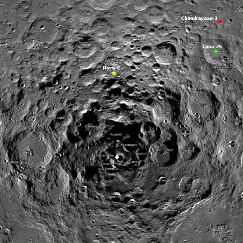
Lunar map showing Hakuto-R's landing spot
Hakuto-R’s planned landing site is in Atlas Crater.

Using its Falcon 9 rocket, SpaceX tonight successfully launched Ispace’s Hakuto-R lunar lander, the first private mission attempting to softly land on the Moon.

The Falcon 9 first stage completed its fifth flight, landing successfully at Cape Canaveral.

Hakuto-R, which is actually the first of two missions, carries seven payloads, including two small rovers, Rashid, which is the United Arab Emirates first lunar mission, and a smaller rover built by Ispace. Both will operate for about a week, one lunar day. Hakuto-R will land on the Moon in April, 2023.

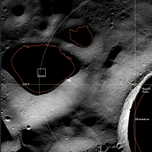
A second payload is a cubesat from JPL, called Lunar Flashlight. It will go into lunar orbit, testing new fuel technologies while also attempting to identify water in the permanently shadowed craters at the lunar south pole.

The leaders in the 2022 launch race:

57 China
56 SpaceX
21 Russia
9 Rocket Lab
8 ULA

The U.S. now leads China 80 to 57 in the national rankings, but trails the entire world combined 87 to 80.

Ancient lava flows down the flanks of the solar system’s largest volcano

Lava flows on Olympus Mons
Click for full image.

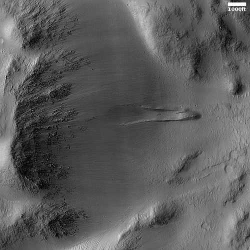
Cool image time! The photo to the right, cropped, reduced, and sharpened to post here, was taken on October 2, 2022 by the high resolution camera on Mars Reconnaissance Orbiter (MRO). It shows what appears to be very old and eroded lava on the northeast flanks of Olympus Mons, the largest volcano on Mars as well as the entire solar system. About 600 miles across, from the edge to its peak, Olympus rises about 54,000 feet, with an actual height relative to Mars’ “sea level” of just under 70,000 feet, more than twice as high as Mount Everest on Earth.

The white arrow show the downward grade. Several different flows can be seen throughout the picture, some confined to a central channel with smooth aprons of overflows on either side. Others are more broken and less coherent, and suggest that either the flows were inherently different, or are much older and have deteriorated with time.
» Read more

Astronomers confirm Webb galaxies from the early universe

Astronomers using Webb have now confirmed with spectroscopy the age of at least four galaxies from the very very early universe, existing only a short time after the theorized Big Bang.

Four of the galaxies studied are particularly special, as they were revealed to be at an unprecedentedly early epoch. The results provided spectroscopic confirmation that these four galaxies lie at redshifts above 10, including two at redshift 13. This corresponds to a time when the universe was approximately 330 million years old, setting a new frontier in the search for far-flung galaxies. These galaxies are extremely faint because of their great distance from us.

The scientists had aimed Webb at Hubble’s Ultra Deep Field, doing a long infrared exposure lasting 28 hours over three days in order to gather the faintest infrared radiation (that Hubble could not see) and thus the most distant galaxies. The spectrum of individuals stars was then measured, which indicating their redshift and their estimated age.

The astronomers will next aim Webb at the more famous Hubble Deep Field, the first such long exposure that optical telescope took back in the late 1990s.

SOFIA to retire to Arizona museum

NASA yesterday announced that its airborne 747 SOFIA telescope will be retired to the Pima Air & Space Museum in Tucson, Arizona, making its final flight there December 13, 2022.

Pima, one of the world’s largest aerospace museums, is developing plans for when and how the SOFIA aircraft will eventually be on display to the public. Along with six hangars, 80 acres of outdoor display grounds, and more than 425 aircraft from around the world, Pima also has its own restoration facility where incoming aircraft like SOFIA are prepared for museum immortalization after their arrival.

While the idea of SOFIA, putting a astronomical telescope on an airplane to get it above most of the atmosphere, has some merit, this particular NASA project was always too costly and simply produced too little science to justify its expense.

In many ways, this museum display will provide one of the best ways to see a 747 itself, now also retired.

Astrobotic’s Peregrine lunar lander passes launch tests

Astrobotic’s first demonstration lunar lander, dubbed Peregrine, has passed its vibration and acoustic tests, demonstrating it can survive launch on ULA’s Vulcan rocket, presently scheduled for the first quarter of ’23.

The lander is now undergoing electromagnetic interference testing, which will be followed by thermal vacuum tests. Once those tests are complete, the company said, it will ship the lander to Cape Canaveral, Florida, to be integrated with the Vulcan Centaur for a launch currently scheduled in the first quarter of 2023. That launch will be the inaugural flight of the Vulcan Centaur.

A great deal will be riding on that first Vulcan launch, both for Astrobotic and ULA.

Webb’s infrared view of the Southern Ring Nebula

Two views of Southern Ring Nebula by Webb
Click for original image.

The two images to the left were produced by the Webb Space Telescope, showing in false colors the Southern Ring Nebula as seen by two of Webb’s infrared cameras.

The two images shown here each combine near-infrared and mid-infrared data to isolate different components of the nebula. The image at [top] highlights the very hot gas that surrounds the central stars. The image at [bottom] traces the star’s scattered molecular outflows that have reached farther into the cosmos.

Based on the data, astronomers posit that up the system could have as many as five stars orbiting each other, with three as yet unseen, or the inner ones might no longer exist, having been absorbed by the bigger stars.

It’s possible more than one star interacted with the dimmer of the two central stars, which appears red in this image, before it created this jaw-dropping planetary nebula. The first star that “danced” with the party’s host created a light show, sending out jets of material in opposite directions. Before retiring, it gave the dim star a cloak of dust. Now much smaller, the same dancer might have merged with the dying star – or is now hidden in its glare.

A third partygoer may have gotten close to the central star multiple times. That star stirred up the jets ejected by the first companion, which helped create the wavy shapes we see today at the edges of the gas and dust. Not to be left out, a fourth star with an orbit projected to be much wider, also contributed to the celebration. It circled the scene, further stirring up the gas and dust, and generating the enormous system of rings seen outside the nebula. The fifth star is the best known – it’s the bright white-blue star visible in the images that continues to orbit predictably and calmly.

Much of this remains mere theory, based on the available data. Nonetheless, the data from many such planetary nebula continues to suggest their strange and wonderful shapes are created by multiple stars, acting as a mix-master to churn up the nebula’s dust.

What a Martian impact looks like on a sheet of slushy ice

Overview map

What a Martian impact looks like on a sheet of ice
Click for full image.

My headline is a bit of a guess, but it is an educated guess for today’s cool image. The photo to the right, cropped, reduced, and sharpened to post here, was taken on October 30, 2022 by the high resolution camera on Mars Reconnaissance Orbiter (MRO).

The location, as indicated by the white dot in the overview map above, puts this impact in a relatively flat area of Deuteronilus Mensae, the westernmost chaos region of the 2,000 mile long mid-latitude strip I call glacier country.

In other words, there is likely a lot of near surface ice here, as this impact makes very plain. If you imagine dropping a pebble into a thick layer of soft ice cream, you might get a crater reminiscent of this. I use for comparison ice cream on Earth because the lighter Martian gravity probably makes Martian ice softer and more slushy.

As I have said many times before, Mars is strange, Mars is mysterious, and above all Mars is alien.

New gamma ray burst violates the explanations of scientists

The uncertainty of science: A newly discovered long gamma ray burst (GRB) that appears to have been formed by the merger of two neutron stars has contradicted the long held views of scientists as to the origin of this particular type of GRB.

Prior to the discovery of this burst, astronomers mostly thought that there were just two ways to produce a GRB. The collapse of a massive star just before it explodes in a supernova could make a long gamma-ray burst, lasting more than two seconds. Or a pair of dense stellar corpses called neutron stars could collide, merge and form a new black hole, releasing a short gamma-ray burst of two seconds or less.

But there had been some outliers. A surprisingly short GRB in 2020 seemed to come from a massive star’s implosion (SN: 8/2/21). And some long-duration GRBs dating back to 2006 lacked a supernova after the fact, raising questions about their origins. “We always knew there was an overlap,” says astrophysicist Chryssa Kouveliotou of George Washington University in Washington, D.C., who wrote the 1993 paper that introduced the two GRB categories, but was not involved in the new work. “There were some outliers which we did not know how to interpret.”

There’s no such mystery about GRB 211211A: The burst lasted more than 50 seconds and was clearly accompanied by a kilonova, the characteristic glow of new elements being forged after a neutron star smashup.

Kouveliotou’s claim is not how I remember things back in 1990s. Then, the astronomers seemed certain that the two GRB classes were entirely separate, with no overlap, despite the large number of uncertainties.

A Martian ship’s prow

A Martian ship's prow
Click for full image.

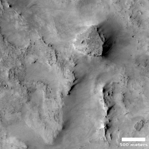
Cool image time! The photo to the right, cropped, reduced, and sharpened to post here, was taken on August 31, 2022 by the high resolution camera on Mars Reconnaissance Orbiter (MRO). It shows what the scientists call “layering” surrounding this pointed mesa, which I roughly estimate to be somewhere between 200 to 400 feet high.

As you approach the mesa you first walk on the dust-covered flat plains. Then you start up a slope of what looks like alluvial fill, material that over time has fallen from the mesa to pile up as an apron at its base. You then reach a series of terraces, each likely marking a different layering major event from sometime in the distance past. Over time, for unknown reasons, the material surrounding this material has eroded away, while the mesa and its layers somehow survived.

The overview map below helps tell us what those past layering events were, as well as the source of the large amount of dust and sand at this location.
» Read more

Computer modelers predict millions will die if China relaxes its zero COVID lockdowns policy

Chicken Little rules again! Scientists, using the same kind of faulty computer models that falsely predicted millions would die in 2020 if we didn’t social distance, wear masks, and shut down all of society (while canceling the Bill of Rights), now predict millions will die in China if that country’s totalitarian communist government relaxes its zero COVID lockdowns policy.

A study based on vaccination rates in March, published in Nature Medicine in May, found that lifting zero-COVID restrictions at that point could “generate a tsunami of COVID-19 cases” over a 6-month period, with 112 million symptomatic cases, 2.7 million intensive care unit (ICU) admissions, and 1.6 million deaths. Peak demand for ICU beds would hit 1 million, more than 15 times the current capacity.

The unvaccinated would account for 77% of the fatalities, according to the authors, primarily at Fudan University. Boosting vaccination rates could slash the toll, but China’s elderly population has remained wary of vaccination. Even today, only 66% of those ages 80 and older have received two doses—versus 90% of the population as a whole—and just 40% have taken boosters.

We of course should trust these scientists without question. How could they possibly be wrong? Bless their hearts. They would never produce junk models simply to promote government overreach and abuse of power.

Ingenuity sets altitude record on 35th flight

Overview map
Click for interactive map.

On December 3, 2022 Ingenuity completed its 35th flight, traveling about 49 feet sideways but reaching a new altitude record for the Mars helicopter of 46 feet.

The map to the right shows the helicopter’s new position by the green dot, with Perseverance’s present position shown with the blue dot. The helicopter only moved slightly to the northwest of its previous position.

The plan had been to test the helicopter’s upgraded software at this new altitude while flying fly 50 feet sideways for 52 seconds at a speed of 6.7 feet per second. The flight met these goals almost exactly, going a distance only slightly shorter, well within its margin of error. The new altitude record however is significant, as going even slight distances higher in Mars’ very thin atmosphere (1/1000th of Earth’s) is challenging, to say the least. This higher flight means Ingenuity can fly up above higher terrain, such as the delta that is Perseverance’s next goal.

InSight’s low power levels holding steady

InSight's power levels as of November 29, 2022

The science team for the Mars’ lander InSight today (December 6th) released a new update (dated November 29th) of the power levels being produced by its dust-covered solar panels.

As of Nov. 29, 2022, InSight is generating an average between 290 watt-hours of energy per Martian day, or sol. The tau, or level of dust cover in the atmosphere, was estimated at .95 (typical tau levels outside of dust season range from 0.6-0.7).

I have added this new data unto the graph to the right, though I am puzzled by the date given to the update. Why post this today, when this update covers data only two days after the previous update (November 27th), and is more than a week out of date? This is especially puzzling because the numbers did not change at all.

Nonetheless, the lander is still alive, but barely. One wonders however what happened in the past week, since today’s update does not bring us up to date.

Martian dunes, as far as the eye can see

Martian dunes
Click for full image.

Cool image time! The photo to the right, cropped, reduced, and sharpened to post here, was taken on July 14, 2022 by the high resolution camera on Mars Reconnaissance Orbiter (MRO). It shows the dune filled floor of an unnamed 25-mile-wide ancient and very eroded Martian crater.

These endless dunes — which extend far beyond this photo to cover the entire floor of this crater as well as an overlapping crater to the north that is only slightly smaller — reveal something fundamental about this location: The winds prevail from one direction consistently, from either the north or the south. Closer inspection would likely resolve which way, but I don’t have the knowledge or access to the data to do so.

The overview map below, provides context, and also further information about why these dunes are here.
» Read more

Curiosity’s recent and future travels amid the Martian mountains

Curiosity's recent and future travels on Mars
Click for full panorama.

Overview map
Click for interactive map.

The panorama above, created from 31 images taken by Curiosity’s right navigation camera on December 5, 2022, provides us a wonderful overview of the rover’s recent and future travels amid the lower foothills of Mount Sharp in Gale Crater.

The overview map to the right provides context. The blue dot indicates Curiosity’s present position. The yellow lines indicate the approximate area viewed by the panorama. The red dotted line indicates Curiosity’s planned route, with the white dots the route it has actually traveled. On the panorama, the pink dotted line indicates where it has been, and the red dotted line where it is going.

For scale, Kukenan is estimated to be about 1,500 feet high. Though Chenapua in front seems comparable, it is actually much smaller, only about 200 to 300 feet high, at the most. Orinoco, though lower on the mountain, is probably about 300 to 400 feet high.

To really see the magnificence of this terrain, you must click on the panorama and explore the full image. Curiosity is truly traveling amid mountains, and is the first human robot to do so on another world.

Martian glaciers below 30 degrees latitude

A Martian glacier below 30 degrees north latitude
Click for full image.

Cool image time! The picture to the right, cropped, reduced, and sharpened to post here, was taken on September 28, 2022 by the high resolution camera on Mars Reconnaissance Orbiter (MRO). While it shows what looks like a somewhat typical Martian glacial flow pushing through a gap between hills, this glacial flow is not typical. It sits at just under 30 degrees north latitude, closer to the equator than almost any glacial feature on Mars. Moreover, the younger impact crater on top suggests this glacier has been here for some time. Though the impact is younger than the crater, it is not that young, as the dark streaks normally seen in the first years after impact are gone.

Thus, this glacier suggests that not only can near surface Martian ice exist closer than 30 degrees latitude from the equator, it can survive there for a considerable amount of time.

Nor is this glacial flow, so close to the equator, unusual for this region of Mars.
» Read more

Sunspot update: The Sun’s unprecedented pause to maximum continues

It is the beginning of the month, and NOAA has once again published its update of its monthly graph that tracks the number of sunspots on the Sun’s Earth-facing hemisphere. Below is the newest graph, adding November’s numbers to the timeline and annotated by me with some additional details added to provide context.

Sunspot activity dropped in November, though still remained significantly higher than the prediction, a sunspot number of 77.6 compared to the predicted number of 57.4. At 77.6, the Sun continues the pause that began in June in the ramp up to solar maximum. For the past half year the Sun’s sunspot output has essentially stalled at approximately the same level.

» Read more

Delays threaten Europa Clipper mission

A variety of issues delaying completion of the science instruments on the Europa Clipper mission are now threatening to prevent the spacecraft from meeting its 2024 launch date.

[W]ith less than two years to go before launch, only three of those instruments have been installed on the main spacecraft body, and five haven’t yet arrived at JPL.

Some context: Europa Clipper has been under development since 1997, though actual design work did not begin until 2013, nine years ago. It presently has a budget of $4.25 billion (more than double its first proposed budget of $2 billion). Yet now, less than years from launch, seven of ten instruments are behind schedule?

What is really disgusting about this story is that it is par for the course for NASA, which almost never finishes anything on time or on budget.

Expanded craters in Martian ice

Expanded craters in Martian ice
Click for full image.

Cool image time! The photo to the right, rotated, cropped, reduced, and sharpened to post here, was taken on August 18, 2022 by the high resolution camera on Mars Reconnaissance Orbiter (MRO). It includes a wide variety of geology related to sublimating ice, including expansion cracks as well as several different examples of what scientists call “expanded craters,” impacts that occurred in near surface ice and have been reshaped by the ice’s melting and sublimation at impact and then later. It also shows some obvious glacial fill in the two distorted craters at the center right.

A 2017 dissertation [pdf] by Donna Viola of the University of Arizona outlines nicely what we know of Martian expanded craters. As she notes in her conclusion:
» Read more

Webb and Keck telescopes track clouds on Titan

Clouds on Titan
Click for original image.

Astronomers have used the Webb Space Telescope and the Keck Observatory in Hawaii to take infrared images days apart of the evolving clouds on the Saturn moon Titan.

The false-color infrared images to the right are those observations. From the press release:

As part of their investigation of Titan’s atmosphere and climate, Nixon’s team used JWST’s Near-Infrared Camera (NIRCam) to observe the moon during the first week of November. After seeing the clouds near Kraken Mare, the largest known liquid sea of methane on the surface of Titan, they immediately contacted the Keck Titan Observing Team to request follow-up observations.

“We were concerned that the clouds would be gone when we looked at Titan a day later with Keck, but to our delight there were clouds at the same positions on subsequent observing nights, looking like they had changed in shape,” said Imke de Pater, emeritus professor of astronomy at the University of California, Berkeley, who leads the Keck Titan Observing Team.

Using Keck Observatory’s second generation Near-Infrared Camera (NIRC2) in combination with the Keck II Telescope’s adaptive optics system, de Pater and her team observed one of Titan’s clouds rotating into and another cloud either dissipating or moving out of Earth’s field of view due to Titan’s rotation.

These images only increase my mourning for a Saturn orbiter. Since the end of Cassini’s mission in 2017, we have essentially been blind to the ringed planet and its many moons. These images, while producing excellent data, also illustrate well what we have lost.

Scientists: Viking-1 might have landed on a field of Martian tsunami debris

The geological history of the Viking-1 Mars landing site

As outlined in their new paper [pdf], a team of scientists now hypothesize that the features that surrounded Viking-1 when it landed on Mars in 1976 were caused by two past Martian tsunamis. Each tsunamis occurred due to an impact in the theorized ocean that is believed to have existed in this part of Mars’ northern lowland plains several billion years ago.

The graphic to the right, figure 8 from the paper, shows the hypothesized sequence of events. From the caption:

(a) Pohl crater forms within a shallow marine environment, (b) triggering tsunami water and debris flow fronts. (c) The wave fronts extensively inundate the highland lowland boundary plains, including a section ~ 900 km southwest of the impact site. (d) The ocean regresses to ~ − 4100 m, accompanied by regional glacier dissection, which erode the rims of Pohl and other craters. (e) The younger tsunami overflows Pohl and parts of the older tsunami. Glaciation continues, and mud volcanoes later source and emerge from the younger tsunami deposit. (f) ~ 3.4 billion years later, the Viking 1 Lander touches down on the edge of the older tsunami deposit.

The overview map below provides the larger context.
» Read more

SpaceX postpones launch of Ispace’s Hakuto-R lunar lander

SpaceX tonight canceled the Falcon 9 launch of the private Hakuto-R lunar lander, built by the Japanese company Ispace and carrying the UAE’s Rashid rover.

After further inspections of the launch vehicle and data review, SpaceX is standing down from Falcon 9’s launch of ispace’s HAKUTO-R Mission 1 from Space Launch Complex 40 (SLC-40) at Cape Canaveral Space Force Station in Florida. A new target launch date will be shared once confirmed.

The first stage had flown four times previously. Apparently during their standard dress rehearsal countdown and fueling before launch they detected something that cannot be immediately resolved.

InSight continues to just hold on

InSight's power levels as of November 27, 2022

The InSight science team today posted another update on the daily power levels the Mars lander’s dust-covered solar panels are producing. The graph to the right includes these new numbers.

As of Nov. 27, 2022, InSight is generating an average between 285 and 295 watt-hours of energy per Martian day, or sol. The tau, or level of dust cover in the atmosphere, was estimated at .95 (typical tau levels outside of dust season range from 0.6-0.7).

The atmosphere is definitely clearing from the dust storm that occurred in October. It also appears that not much of this dust is settling on InSight’s solar panels, since the daily power level has not dropped significantly.

Nonetheless, at these very low power levels, InSight’s future remains day-to-day. Unless it finally gets lucky and a dust devil blows the solar panels clear so more power can be generated, the mission will end should two scheduled communications sessions in a row fail to make contact.

Traveling in the mountains of Mars

Traveling in the mountains of Mars
Click for full resolution. Original images can be found here and here.

Overview map
Click for interactive map.

Cool image time! The panorama above was created by two photos taken by the Mars rover Curiosity’s right navigation camera on November 30, 2022. It looks to the south, into Gediz Vallis, the slot canyon that has been the rover’s major goal since it landed in Gale Crater a decade ago.

The blue dot on the overview map to the right marks Curiosity’s present position, now on its way east after making a short detour to the west towards Gediz Vallis Ridge. The yellow lines indicate the approximate area shown by this panorama. The red dotted line in both images marks the rover’s planned future route. The white arrows indicate what scientists have labeled the marker band, a distinct smooth layer seen at about the same elevation in many places on the flanks of Mount Sharp. According to the most recent update from the science team, the rover’s next drive will place it on that marker band, the second time it has been there.

From here the rover will continue south, climbing up into Gediz Vallis.

China completes construction of world’s largest solar radio telescope array

China has now completed the construction of world’s largest solar radio telescope array, dubbed the Daocheng Solar Radio Telescope (DSRT), made up of 313 separate radio dishes laid out in a giant two-mile wide circle.

DSRT is focused on observing solar flares and coronal mass ejections (CMEs) which can interfere with or overload electronics and wreak havoc on and above Earth. CMEs are triggered by realignments in the star’s magnetic field that occur in sunspots, and when directed at Earth, can threaten power grids, telecommunications, orbiting satellites and even put the safety of astronauts aboard the International Space Station and China’s newly-completed Tiangong space station at risk.

Assuming China shares the data from this telescope with the rest of the world, it will function as a back-up to several very old NOAA satellites in orbit that NOAA has failed to replace. If China doesn’t share the data, however, the western world will become very vulnerable should its own satellites finally fail.

A Martian knife mesa with terraces

A Martian knife mesa with terraces
Click for full image.

Cool image time! The photo to the right, rotated, cropped, reduced, and sharpened to post here, was taken on August 21, 2022 by the high resolution camera on Mars Reconnaissance Orbiter (MRO). It shows what the scientists label as a “layered mound.” It also shows a plethora of geological mysteries, all of which relate to the as yet not quite understood geological history of Mars.

First, note the different colors north and south of the ridgeline. According to the science team’s understanding of what these colors mean [pdf], the orange-red to the north suggests dust, while the bluish-green to the south suggests coarser materials, such as rocks and sand. Though frost and ice are generally bluer, such things are generally found on the pole-facing slopes where there is less sunlight. Thus the bluish-green material to the south is unlikely to be ice or frost, though this is not impossible, as the picture was taken in the winter and the latitude is 35 degrees north.

Why however is there such a dichotomy of rocks, sand, and dust between the north and south slopes? And if frost and ice, why is it more prominent to the south, when it should instead be more prominent to the north?

Other mysteries: Is the circular depression on the ridgetop an impact crater or a caldera? If the latter, this suggests the mound is some kind of volcano, likely mud, though lava is not excluded. If so, however, why is there no caldera on top of the ridge to the south?

The location, as shown in the overview map below, reveals other puzzles.
» Read more

A ghost goddess in space

Ghost goddess in space
Click for original image.

Cool image time! The image to the right, cropped, rotated, reduced, and enhanced to post here, is without doubt one of my favorite objects that the Hubble Space Telescope has photographed over the decades. This new image combines imagery obtained by earlier Hubble cameras and the newer cameras installed in 2009.

The delicate sheets and intricate filaments are debris from the cataclysmic death of a massive star that once lived in the Large Magellanic Cloud, a small satellite galaxy of the Milky Way. DEM L 190 — also known as LMC N49 — is the brightest supernova remnant in the Large Magellanic Cloud and lies approximately 160 000 light-years away from Earth in the constellation Dorado.

What makes this supernova remnant so visually appealing to my eye is its ghostly resemblance to a woman’s face, her hair blowing freely to the right. The original 2003 Hubble picture, shown below, has been the desktop image of my computer for almost two decades.
» Read more

Monitoring the tiger stripes on Martian dunes

Dunes with tiger stripes
Click for full image.

Today’s cool image takes us back to a previous cool image, from December 2020. The photo to the right, rotated, cropped, reduced, and enhanced to post here, was taken on August 22, 2022 as part of a regular monitoring program of these worm-shaped and tiger-striped dunes in 42-mile-wide Kunowsky Crater, located in the northern lowland plains of Mars at the high mid-latitude of 57 degrees north.

The tiger stripes appear to be the northern hemisphere’s version of what are called “spiders” in the south, where each spring the mantle of dry ice that settles on the surface in winter begins to sublimate away, from the bottom up. The trapped gas eventually escapes at the mantle’s weak points where it cracks.

When the gas escapes it spews dust onto the surface, creating the dark patches. In the southern hemisphere, the ground is generally stable, and the gas travels and escapes along the same routes each year, creating relatively permanent spider-like tributary patterns. In the north the ground is less stable, so the dark streaks form more randomly from year to year.

This monitoring campaign, first begun in 2008, is looking to see how these seasonal changes might change these northern dunes. The white rectangle in the image shows an area shown in close-up below, comparing 2020 with 2022 to see what changes might have occurred.
» Read more

JAXA: one of Japan’s astronauts fabricated data in ground-based experiment

According to Japan’s space agency JAXA, one of its astronauts, Satoshi Furukawa, falsified and fabricated the research results of a ground-based experiment run from 2015 to 2017.

The experiment asked a total of 42 test subjects to spend 14 days in a mock space station, during which blood and urine samples were collected.

A JAXA probe later found multiple misconduct with the research, including creating data without a supervisory researcher and intentionally rewriting evaluations. The study also lacked sufficient assessment methods and adequate research notes, and the credibility of the data wasn’t assured.

These wrongdoings were discovered after the experiments had been completed, and since the research was subsequently suspended no papers were published.

Furukawa is scheduled to fly to ISS in ’23. Though JAXA says he and his research team will be punished, it is unclear whether that means his flight has been canceled.

1 46 47 48 49 50 276