Delays threaten Europa Clipper mission

A variety of issues delaying completion of the science instruments on the Europa Clipper mission are now threatening to prevent the spacecraft from meeting its 2024 launch date.

[W]ith less than two years to go before launch, only three of those instruments have been installed on the main spacecraft body, and five haven’t yet arrived at JPL.

Some context: Europa Clipper has been under development since 1997, though actual design work did not begin until 2013, nine years ago. It presently has a budget of $4.25 billion (more than double its first proposed budget of $2 billion). Yet now, less than years from launch, seven of ten instruments are behind schedule?

What is really disgusting about this story is that it is par for the course for NASA, which almost never finishes anything on time or on budget.

Expanded craters in Martian ice

Expanded craters in Martian ice
Click for full image.

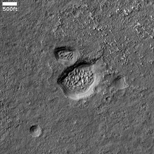
Cool image time! The photo to the right, rotated, cropped, reduced, and sharpened to post here, was taken on August 18, 2022 by the high resolution camera on Mars Reconnaissance Orbiter (MRO). It includes a wide variety of geology related to sublimating ice, including expansion cracks as well as several different examples of what scientists call “expanded craters,” impacts that occurred in near surface ice and have been reshaped by the ice’s melting and sublimation at impact and then later. It also shows some obvious glacial fill in the two distorted craters at the center right.

A 2017 dissertation [pdf] by Donna Viola of the University of Arizona outlines nicely what we know of Martian expanded craters. As she notes in her conclusion:
» Read more

Webb and Keck telescopes track clouds on Titan

Clouds on Titan
Click for original image.

Astronomers have used the Webb Space Telescope and the Keck Observatory in Hawaii to take infrared images days apart of the evolving clouds on the Saturn moon Titan.

The false-color infrared images to the right are those observations. From the press release:

As part of their investigation of Titan’s atmosphere and climate, Nixon’s team used JWST’s Near-Infrared Camera (NIRCam) to observe the moon during the first week of November. After seeing the clouds near Kraken Mare, the largest known liquid sea of methane on the surface of Titan, they immediately contacted the Keck Titan Observing Team to request follow-up observations.

“We were concerned that the clouds would be gone when we looked at Titan a day later with Keck, but to our delight there were clouds at the same positions on subsequent observing nights, looking like they had changed in shape,” said Imke de Pater, emeritus professor of astronomy at the University of California, Berkeley, who leads the Keck Titan Observing Team.

Using Keck Observatory’s second generation Near-Infrared Camera (NIRC2) in combination with the Keck II Telescope’s adaptive optics system, de Pater and her team observed one of Titan’s clouds rotating into and another cloud either dissipating or moving out of Earth’s field of view due to Titan’s rotation.

These images only increase my mourning for a Saturn orbiter. Since the end of Cassini’s mission in 2017, we have essentially been blind to the ringed planet and its many moons. These images, while producing excellent data, also illustrate well what we have lost.

Scientists: Viking-1 might have landed on a field of Martian tsunami debris

The geological history of the Viking-1 Mars landing site

As outlined in their new paper [pdf], a team of scientists now hypothesize that the features that surrounded Viking-1 when it landed on Mars in 1976 were caused by two past Martian tsunamis. Each tsunamis occurred due to an impact in the theorized ocean that is believed to have existed in this part of Mars’ northern lowland plains several billion years ago.

The graphic to the right, figure 8 from the paper, shows the hypothesized sequence of events. From the caption:

(a) Pohl crater forms within a shallow marine environment, (b) triggering tsunami water and debris flow fronts. (c) The wave fronts extensively inundate the highland lowland boundary plains, including a section ~ 900 km southwest of the impact site. (d) The ocean regresses to ~ − 4100 m, accompanied by regional glacier dissection, which erode the rims of Pohl and other craters. (e) The younger tsunami overflows Pohl and parts of the older tsunami. Glaciation continues, and mud volcanoes later source and emerge from the younger tsunami deposit. (f) ~ 3.4 billion years later, the Viking 1 Lander touches down on the edge of the older tsunami deposit.

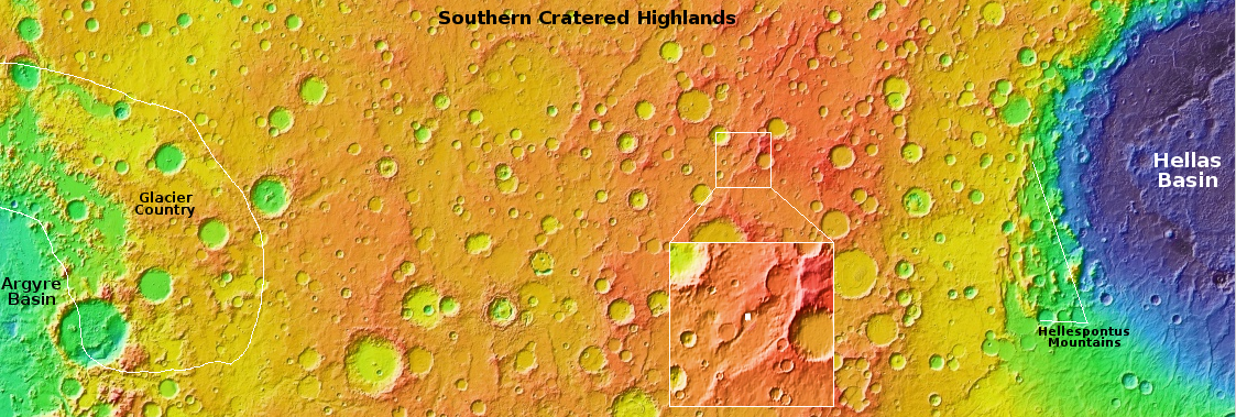
The overview map below provides the larger context.
» Read more

SpaceX postpones launch of Ispace’s Hakuto-R lunar lander

SpaceX tonight canceled the Falcon 9 launch of the private Hakuto-R lunar lander, built by the Japanese company Ispace and carrying the UAE’s Rashid rover.

After further inspections of the launch vehicle and data review, SpaceX is standing down from Falcon 9’s launch of ispace’s HAKUTO-R Mission 1 from Space Launch Complex 40 (SLC-40) at Cape Canaveral Space Force Station in Florida. A new target launch date will be shared once confirmed.

The first stage had flown four times previously. Apparently during their standard dress rehearsal countdown and fueling before launch they detected something that cannot be immediately resolved.

InSight continues to just hold on

InSight's power levels as of November 27, 2022

The InSight science team today posted another update on the daily power levels the Mars lander’s dust-covered solar panels are producing. The graph to the right includes these new numbers.

As of Nov. 27, 2022, InSight is generating an average between 285 and 295 watt-hours of energy per Martian day, or sol. The tau, or level of dust cover in the atmosphere, was estimated at .95 (typical tau levels outside of dust season range from 0.6-0.7).

The atmosphere is definitely clearing from the dust storm that occurred in October. It also appears that not much of this dust is settling on InSight’s solar panels, since the daily power level has not dropped significantly.

Nonetheless, at these very low power levels, InSight’s future remains day-to-day. Unless it finally gets lucky and a dust devil blows the solar panels clear so more power can be generated, the mission will end should two scheduled communications sessions in a row fail to make contact.

Traveling in the mountains of Mars

Traveling in the mountains of Mars
Click for full resolution. Original images can be found here and here.

Overview map
Click for interactive map.

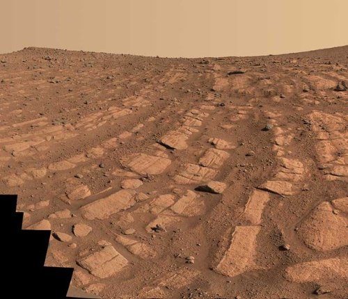
Cool image time! The panorama above was created by two photos taken by the Mars rover Curiosity’s right navigation camera on November 30, 2022. It looks to the south, into Gediz Vallis, the slot canyon that has been the rover’s major goal since it landed in Gale Crater a decade ago.

The blue dot on the overview map to the right marks Curiosity’s present position, now on its way east after making a short detour to the west towards Gediz Vallis Ridge. The yellow lines indicate the approximate area shown by this panorama. The red dotted line in both images marks the rover’s planned future route. The white arrows indicate what scientists have labeled the marker band, a distinct smooth layer seen at about the same elevation in many places on the flanks of Mount Sharp. According to the most recent update from the science team, the rover’s next drive will place it on that marker band, the second time it has been there.

From here the rover will continue south, climbing up into Gediz Vallis.

China completes construction of world’s largest solar radio telescope array

China has now completed the construction of world’s largest solar radio telescope array, dubbed the Daocheng Solar Radio Telescope (DSRT), made up of 313 separate radio dishes laid out in a giant two-mile wide circle.

DSRT is focused on observing solar flares and coronal mass ejections (CMEs) which can interfere with or overload electronics and wreak havoc on and above Earth. CMEs are triggered by realignments in the star’s magnetic field that occur in sunspots, and when directed at Earth, can threaten power grids, telecommunications, orbiting satellites and even put the safety of astronauts aboard the International Space Station and China’s newly-completed Tiangong space station at risk.

Assuming China shares the data from this telescope with the rest of the world, it will function as a back-up to several very old NOAA satellites in orbit that NOAA has failed to replace. If China doesn’t share the data, however, the western world will become very vulnerable should its own satellites finally fail.

A Martian knife mesa with terraces

A Martian knife mesa with terraces
Click for full image.

Cool image time! The photo to the right, rotated, cropped, reduced, and sharpened to post here, was taken on August 21, 2022 by the high resolution camera on Mars Reconnaissance Orbiter (MRO). It shows what the scientists label as a “layered mound.” It also shows a plethora of geological mysteries, all of which relate to the as yet not quite understood geological history of Mars.

First, note the different colors north and south of the ridgeline. According to the science team’s understanding of what these colors mean [pdf], the orange-red to the north suggests dust, while the bluish-green to the south suggests coarser materials, such as rocks and sand. Though frost and ice are generally bluer, such things are generally found on the pole-facing slopes where there is less sunlight. Thus the bluish-green material to the south is unlikely to be ice or frost, though this is not impossible, as the picture was taken in the winter and the latitude is 35 degrees north.

Why however is there such a dichotomy of rocks, sand, and dust between the north and south slopes? And if frost and ice, why is it more prominent to the south, when it should instead be more prominent to the north?

Other mysteries: Is the circular depression on the ridgetop an impact crater or a caldera? If the latter, this suggests the mound is some kind of volcano, likely mud, though lava is not excluded. If so, however, why is there no caldera on top of the ridge to the south?

The location, as shown in the overview map below, reveals other puzzles.
» Read more

A ghost goddess in space

Ghost goddess in space
Click for original image.

Cool image time! The image to the right, cropped, rotated, reduced, and enhanced to post here, is without doubt one of my favorite objects that the Hubble Space Telescope has photographed over the decades. This new image combines imagery obtained by earlier Hubble cameras and the newer cameras installed in 2009.

The delicate sheets and intricate filaments are debris from the cataclysmic death of a massive star that once lived in the Large Magellanic Cloud, a small satellite galaxy of the Milky Way. DEM L 190 — also known as LMC N49 — is the brightest supernova remnant in the Large Magellanic Cloud and lies approximately 160 000 light-years away from Earth in the constellation Dorado.

What makes this supernova remnant so visually appealing to my eye is its ghostly resemblance to a woman’s face, her hair blowing freely to the right. The original 2003 Hubble picture, shown below, has been the desktop image of my computer for almost two decades.
» Read more

Monitoring the tiger stripes on Martian dunes

Dunes with tiger stripes
Click for full image.

Today’s cool image takes us back to a previous cool image, from December 2020. The photo to the right, rotated, cropped, reduced, and enhanced to post here, was taken on August 22, 2022 as part of a regular monitoring program of these worm-shaped and tiger-striped dunes in 42-mile-wide Kunowsky Crater, located in the northern lowland plains of Mars at the high mid-latitude of 57 degrees north.

The tiger stripes appear to be the northern hemisphere’s version of what are called “spiders” in the south, where each spring the mantle of dry ice that settles on the surface in winter begins to sublimate away, from the bottom up. The trapped gas eventually escapes at the mantle’s weak points where it cracks.

When the gas escapes it spews dust onto the surface, creating the dark patches. In the southern hemisphere, the ground is generally stable, and the gas travels and escapes along the same routes each year, creating relatively permanent spider-like tributary patterns. In the north the ground is less stable, so the dark streaks form more randomly from year to year.

This monitoring campaign, first begun in 2008, is looking to see how these seasonal changes might change these northern dunes. The white rectangle in the image shows an area shown in close-up below, comparing 2020 with 2022 to see what changes might have occurred.
» Read more

JAXA: one of Japan’s astronauts fabricated data in ground-based experiment

According to Japan’s space agency JAXA, one of its astronauts, Satoshi Furukawa, falsified and fabricated the research results of a ground-based experiment run from 2015 to 2017.

The experiment asked a total of 42 test subjects to spend 14 days in a mock space station, during which blood and urine samples were collected.

A JAXA probe later found multiple misconduct with the research, including creating data without a supervisory researcher and intentionally rewriting evaluations. The study also lacked sufficient assessment methods and adequate research notes, and the credibility of the data wasn’t assured.

These wrongdoings were discovered after the experiments had been completed, and since the research was subsequently suspended no papers were published.

Furukawa is scheduled to fly to ISS in ’23. Though JAXA says he and his research team will be punished, it is unclear whether that means his flight has been canceled.

Perseverance data so far finds no evidence of lake in Jezero Crater

The uncertainty of science: Though scientists had assumed the presence of an ancient delta that once flowed into Jezero Crater meant a lake once filled the crater, Perseverance data from its first year of roving has so far found no evidence that a lake every existed.

[A] summary of the first year of data from the rover, published in three different papers being released today, suggests that Perseverance has yet to stumble across any evidence of a watery paradise. Instead, all indications are that water exposure in the areas it explored was limited, and the waters were likely to be near freezing. While this doesn’t rule out that it will find lake deposits later, the environment might not have been as welcoming for life as “a lake in a crater” might have suggested.

Jezero Crater, like Gale Crater where Curiosity is roving, is located in the Martian dry equatorial regions. Though the data from Gale suggests a lake had once existed there, the data also suggests strongly that any water there acted more like water in cold climates like Iceland, existing mostly as glacial ice.

The jury is still out, but these results from Perseverance once again point to ice and glaciers as a possible explanation for many of the geological features on Mars that we on Earth automatically assume were caused by liquid water.

Ingenuity completes 34th flight using new hazard avoidance software

Overview map
Click for interactive map.

Ingenuity yesterday completed its 34th flight on Mars, a short vertical up-and-down flight lasting only eighteen seconds in order to test just installed new hazard avoidance software.

The tan dotted line on the map to the right shows Ingenuity’s recent flights and ends where it sits today. The white dotted line marks Perseverance’s travels.

Ingenuity’s navigation software was designed to assume the vehicle was flying over flat terrain. When the helicopter is flying over terrain like hills, this flat-ground assumption causes Ingenuity’s navigation software to think the vehicle is veering, causing Ingenuity to start actually veering in an attempt to counter the error. Over long flights, navigation errors caused by rough terrain must be accounted for, requiring the team to select large airfields. This new software update corrects this flat-ground assumption by using digital elevation maps of Jezero Crater to help the navigation software distinguish between changes in terrain and vehicle movement. This increases Ingenuity’s accuracy, allowing the pilots to target smaller airfields going forward.

The new software is part of an effort to use Ingenuity to test helicopter flying in Jezero Crater in preparation for the two sample return helicopters which will eventually land here to grab Perservance’s core samples and bring them to the ascent vehicle for return to Earth.

Frozen glacial eddies on Mars?

Overview map

Frozen glacial eddies on Mars?
Click for full image.

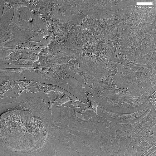
Cool image time! The photo to the right, cropped, reduced, and enhanced to post here, was taken on August 26, 2022 by the high resolution camera on Mars Reconnaissance Orbiter (MRO). Though the science team labels this image vaguely as showing “Features in Mamers Valles,” the features are likely glacial ice since this location is at the western end of the 2,000-mile-long northern mid-latitude strip I dub glacier country, where glacial features are seen everywhere.

The white dot marks this picture’s location in Mamers Valles, as shown on the overview map above. This particular Martian channel, that meanders in a wildly random manner (including a few sharp ninety degree turns), is theorized [pdf] by some scientists to have formed not by surface flows but by a subterranean drainage that created voids. On the surface the voids caused sagging, collapses, and the eventual formation of the surface channel.

Under such conditions, any ice in the channel would not necessarily have a clear flow direction, thus providing an explanation (though hardly certain) of the eddy-like shape of these features.

Webb makes its first detailed survey of an exoplanet’s atmosphere

Astronomers have now completed the first detailed survey of an exoplanet’s atmosphere using the Webb Space Telescope, looking at a gas giant about one third the mass of Jupiter about 700 light years away.

Using three of its instruments, JWST was able to observe light from the planet’s star as it filtered through WASP-39b’s atmosphere, a process known as transmission spectroscopy. This allowed a team of more than 300 astronomers to detect water, carbon monoxide, sodium, potassium and more in the planet’s atmosphere, in addition to the carbon dioxide. The gives the planet a similar composition to Saturn, although it has no detectable rings.

The team were also surprised to detect sulfur dioxide, which had appeared as a mysterious bump in early observation data. Its presence suggests a photochemical reaction is taking place in the atmosphere as light from the star hits it, similar to how our Sun produces ozone in Earth’s atmosphere. In WASP-39b’s case, light from its star, slightly smaller than the Sun, splits water in its atmosphere into hydrogen and hydroxide, which reacts with hydrogen sulfide to produce sulfur dioxide.

The data also suggested the clouds in the atmosphere are patchy, and that the planet’s formation process was not exactly as predicted.

These observations are part of a program to study 70 exoplanets during Webb’s first year of operation, using its infrared capabilities to get spectroscopy not possible in other wavelengths.

First commercial passenger spacewalk on Dragon will involve depressurizing entire spacecraft

According to an interview to Space.com by the four crew members on next year’s private manned Dragon flight financed by Jared Isaacman, the spacewalk, the first involving commercial passengers, will include all four passengers, since Dragon will not have an airlock and will be depressurized entirely when the hatch opens.

“We’ve collectively taken the position that we’re all going for an EVA,” Isaacman said, adding that the spacecraft cabin is to be depressurized in a hard vacuum. “Whether you’re sticking your head outside, you are doing an EVA. We are contemplating two people on the outside of the vehicle,” Isaacman said, “and two would be inside making sure that everything is going correct.”

To accommodate the spacewalk, this Crew Dragon will not be outfitted with a transparent dome, as was the case for the Inspiration4 mission.

The mission is presenting targeting March ’23 for launch.

Curiosity’s wheels: Maybe not so bad after all

Comparison of one wheel on Curiosity
To see the original images, go here and here.

Today the science team for the Mars rover Curiosity downloaded more photos of its wheels, a survey taken routinely now after every 500 meters or 1640 feet of travel. Unlike the pictures made available yesterday that showed some of the worst damage to one of Curiosity’s middle wheels, these new images included the wheel I have been tracking since 2017 as a baseline to see if further damage has occurred.

The photos to the right show that wheel, with the top photo from August and the bottom created from two pictures taken on November 20, 2022. The numbers indicate the matching treads. The “+” sign in the top image indicates a location where new damage was spotted in August.

As you can see, this wheel does not appear to have experienced any additional damage in the more than three months since that August update. While the damage to Curiosity’s wheels remains very concerning, it does appear based on this one wheel that — despite the generally very rough terrain the rover has been traversing since it entered the foothills of Mount Sharp — the wheels in general seem to be holding up.

Though I have not done a careful comparison of these new wheel images with earlier ones, none of the new images appear to show any additional significant damage. It appears that the travel criteria the science team adopted years ago — right after discovering the wheel damage — continues to work to protect the wheels. It picks the rover’s path more carefully to avoid sharper rocks, and includes software that stops the rover should it sense it is crossing a rock sharper than desired.

Six of the ten cubesats launched toward the Moon by SLS still working

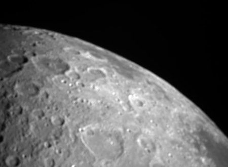
The Moon as seen by ArgoMoon
Click for full image.

Of the ten cubesats launched toward the Moon by SLS last week, six are still working while four have problems that are likely killing their missions.

The photo to the right, cropped, reduced, and sharpened to post here, was taken by ArgoMoon, an Italian cubesat that is working perfectly. The large impact basin visible is Orientale Basin, located just on the edge of the visible face of the Moon but partly hidden on the far side.

A summary of the status of all ten can be found here. Of the other five still functioning properly, all have been able to maintain proper communications.

Possibly the biggest disappointment however is the failure of Japan’s Omotenashi lander, which was going to attempt a lunar soft landing. Shortly after launch it began tumbling, and engineers were never able to regain full control or communications. The landing attempt has now been abandoned.

Side note: Orion itself also captured some images as it zipped past the Moon yesterday, but they do not appear as high quality as ArgoMoon’s pictures.

Astronomers spot asteroid mere hours before it burned up in Earth’s atmosphere

For only the sixth time, astronomers this past weekend were able to image an asteroid just before it hit the Earth’s atmosphere and burned up over Canada.

The mini-asteroid, less than 3 feet (1 meter) wide, was spotted by astronomer David Rankin at Mount Lemmon Observatory in Arizona, according to SpaceWeather.com. Subsequent observations by other astronomers confirmed that the rock, coming from the direction of the main asteroid belt between the orbits of Mars and Jupiter, was on a collision course with Earth.

Only three hours after the first detection, the object, since dubbed C8FF042, sliced through the sky above Canada and landed in Lake Ontario, according to NASA.

While it is believed that most of the meteorite’s pieces that reached the ground fell into Lake Ontario, there is a chance some pieces might still be found along the south coast of the lake between Hamiliton and Niagara Falls.

InSight still alive

InSight's power levels

The InSight science team today posted another update on the power status of the Mars lander, as shown in the graph to the right.

As of Nov. 21, 2022, InSight is generating an average between 300 and 310 watt-hours of energy per Martian day, or sol. The tau, or level of dust cover in the atmosphere, was estimated at 1.33 (typical tau levels outside of dust season range from 0.6-0.7).

Power levels, while critically low, remained level and sufficient to run the seismometer, though nothing else. At the beginning of the month the science team said these levels would only allow operations for a few more weeks, but here we are, a few weeks later, and InSight is still alive, though barely.

At this moment the situation is essentially day-to-day. If the lander misses two scheduled communications sessions, they will declare it dead. So far, that has not happened.

New serious damage to Curiosity’s wheels?

New damage to Curiosity's wheels?
Click for original image.

I must start this post with a strong caveat. The serious damage, as posted to the right, of the zig-zag growser treads on one of Curiosity’s wheels that was photographed by one of the rover’s cameras yesterday and downloaded today, could very well not be new damage. As noted in a report in June:

The team discovered that the left middle wheel had damaged one of its grousers, the zig-zagging treads along Curiosity’s wheels. This particular wheel already had four broken grousers, so now five of its 19 grousers are broken.

The damaged wheel to the right appears to be that left middle wheel. This photo thus might simply be documenting the damage noted in June, and not new damage. Since Curiosity has six wheels (three on each side), the middle wheels like this one are likely slightly less critical and can be worked around should it no longer function well.

Nonetheless, the damage to these growsers is of concern. Previously, the wheel damage has consistently involved breakage in the metal plates between the growsers. Though the science team noted in that June report that it has “proven through ground testing that we can safely drive on the wheel rims if necessary”, the team also said that it did not think that was going to happen soon.

Based on this image, however, it is happening, at least on one wheel. Fortunately, a review of all the images downloaded yesterday does not show any other broken growsers on any other wheel, though the image survey is not thorough and does not cover the entire surface of every wheel. For example, I could not identify any images of the damaged sections of the wheel that I have been tracking since 2017. It could be that the photo’s orientation this time was significantly different, making it difficult to find a match. It could also be that the damage had increased so much that no match with an earlier photo was easily possible. Or it could simply be that the same section on the wheel was not photographed this time.

Either way, the damage on this middle wheel foreshadows the rover’s eventual future, a future that is likely getting closer because of the roughness of the mountain and rocky terrain that Curiosity is presently traveling, and appears to have no end as it now climbs Mount Sharp.

Smeared colliding galaxies

Smeared colliding galaxies
Click for full image.

Cool image time! The photo to the right, cropped and reduced to post here, was taken by the Hubble Space Telescope as part of its continuing program to collect images of unusual galaxies that had previously not been observed at high resolution.

The Arp-Madore catalogue is a collection of particularly peculiar galaxies spread throughout the southern sky, and includes a collection of subtly interacting galaxies as well as more spectacular colliding galaxies. Arp-Madore 417-391, which lies around 670 million light-years away in the constellation Eridanus in the southern celestial hemisphere, is one such galactic collision. The two galaxies have been distorted by gravity and twisted into a colossal ring, leaving the cores of the two galaxies nestled side by side.

It is likely that this collision has been going on for many millions of years, and will not be over for many millions of years to come. In the end the two galaxies will likely merge into one whose final shape cannot be predicted.

Lucy engineers again attempt to complete deployment of solar array

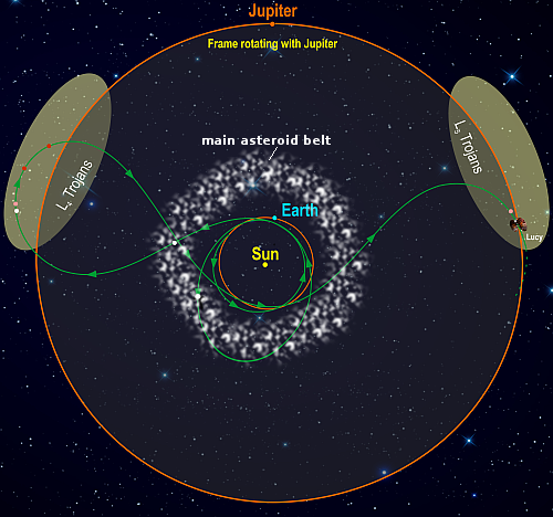
Lucy solar panel graphic
Artist’s impression of solar panel

On November 7, 2022, the Lucy science team made another attempt to complete the deployment of one of the spacecraft’s two solar arrays, as shown in the graphic to the right. After launch that array failed to deploy properly, and though later attempts have gotten it mostly open, it has not latched tight.

On Monday, Nov. 7, the spacecraft was instructed to point toward the Sun and operate the array deployment motors for a short period of time. As expected, the latest attempt deployed the wing incrementally forward, but it did not latch. The operation did succeed in providing the team with data to evaluate the array’s status and ascertain any changes since the last deployment attempt on June 16.

During this analysis, the team identified that a small vibration occurred as the unlatched array interacted with the spacecraft’s attitude controller while the array was pointed toward Earth and at a cold temperature. The vibration did not occur as a result of the deployment activity itself. While this vibration is too small to pose a risk to the spacecraft in its current state, further array deployment attempts have been paused while the attitude controller is updated to resolve this issue. In the meantime, the spacecraft was reoriented so that the array is warmer, and the team found that the vibration is not present. The team will re-evaluate further redeployment activities once the updates to the controller are checked out on the spacecraft.

In other words, engineers have decided to halt further deployment attempts until they understand fully the cause of this vibration.

At present, the spacecraft is in good health, and the array, only a few degrees short of full deployment, is producing more than 90% of its expected power, more than enough to run the full mission.

Webb finding more galaxies in early universe than expected

The uncertainty of science: Astronomers using the Webb Space Telescope are finding in very early universe many more galaxies that are also far more developed then had been predicted.

The Webb observations nudge astronomers toward a consensus that an unusual number of galaxies in the early universe were so much brighter than expected. This will make it easier for Webb to find even more early galaxies in subsequent deep sky surveys, say researchers.

“We’ve nailed something that is incredibly fascinating. These galaxies would have had to have started coming together maybe just 100 million years after the big bang. Nobody expected that the dark ages would have ended so early,” said Garth Illingworth of the University of California at Santa Cruz, a member of the Naidu/Oesch team. “The primal universe would have been just one hundredth its current age. It’s a sliver of time in the 13.8 billion-year-old evolving cosmos.”

Erica Nelson of the University of Colorado in Boulder, a member of the Naidu/Oesch team, noted that “our team was struck by being able to measure the shapes of these first galaxies; their calm, orderly disks question our understanding of how the first galaxies formed in the crowded, chaotic early universe.”

The galaxies are smaller, more compact than present day galaxies, and appear to be forming stars at a tremendous rate. Because their distances, presently estimated, still need to be confirmed by spectroscopy, these conclusions remain somewhat tentative though quite alluring.

We should not be surprised if in the next two years data from Webb will overturn almost all the theories that presently exist about the Big Bang and its immediate aftermath.

A hidden baby star, seen in infrared

A hidden baby star, seen in infrared
Click for original image.

Using the Webb Space Telescope, astronomers have obtained a new high resolution infrared false color view of the bi-polar jets of a new solar system and star, hidden within its dark cloud of dust.

That image is the photo to the right, reduced and sharpened to post here. From the press release:

NASA’s James Webb Space Telescope has revealed the once-hidden features of the protostar within the dark cloud L1527, providing insight into the beginnings of a new star. These blazing clouds within the Taurus star-forming region are only visible in infrared light, making it an ideal target for Webb’s Near-Infrared Camera (NIRCam).

The protostar itself is hidden from view within the “neck” of this hourglass shape. An edge-on protoplanetary disk is seen as a dark line across the middle of the neck. Light from the protostar leaks above and below this disk, illuminating cavities within the surrounding gas and dust.

The region’s most prevalent features, the clouds colored blue and orange in this representative-color infrared image, outline cavities created as material shoots away from the protostar and collides with surrounding matter. The colors themselves are due to layers of dust between Webb and the clouds. The blue areas are where the dust is thinnest. The thicker the layer of dust, the less blue light is able to escape, creating pockets of orange.

Scientists estimate this star is only about 100,000 years old, and is in its earliest stage of formation. That protoplanetary disk is estimated to be about the size of our solar system.

The lunar surface is arid

The uncertainty of science: According to a paper published at the end of October, scientists have used data from the LADEE lunar orbiter (that circled the Moon in 2013-2014) and found that the surface of the Moon is extremely arid, and if there is any ice trapped in the permanently shadowed craters at the poles it did not come from meteorite impacts elsewhere on the Moon. From the abstract:

The upper bound for exospheric water derived here from data collected in 2013–2014 by the neutral mass spectrometer on the Lunar Atmosphere and Dust Environment Explorer spacecraft [LADEE], about three molecules/cc, pales in comparison to the concentration of ∼15,000 molecules/cc needed to sequester the meteoritic water influx. The only pragmatic conclusion is that the hypothesis for water ice accumulation at the poles due to exospheric transport is false.

The theory had been that any water from these meteorites could have been transported by various processes to the polar cold traps. This data says that did not happen, and if there is water ice in the polar cold traps, its origin remains unknown, though comet impacts at the poles might have been a source.

This result also appears to contradict other orbital data that has suggested there is some water in the lunar regolith at mid and low latitudes.

Martian helicopters of the future

Today Bob Balaram, the chief engineer for the Mars helicopter Ingenuity, wrote up a short essay summarizing the helicopter’s successes on Mars.

This aircraft, very much also a spacecraft, has been on its own on the surface of Mars, detached from its traveling companion Perseverance, for over 500 Martian days or sols. It has operated way beyond its original planned mission of 30 sols, including surviving a brutal winter that it was not designed for. With 33 flights, almost an hour of flight time, over 7 km of travel in Jezero crater, takeoffs and landings from 25 airfields, almost 4000 navigation camera images, and 200 high-resolution color images, it has proven its worth as a scout for both scientists and rover planners. Currently, it is getting ready to use its fourth software update – this one with advanced navigation capabilities that will allow it to safely fly up the steep terrain of the Jezero river delta, scouting ahead of the rover Perseverance as it searches for signs of past life on Mars. [emphasis mine]

I have highlighted the number of flights above because Ingenuity was supposed to do a very short 34th flight on November 10th that would only have the helicopter go straight up 16 feet, hover, and then come straight back down. Yet, I have seen no postflight reports, and Ingenuity’s flight log still does not include it as of today. One image from Ingenuity that was taken on November 9th has been released, and shows the ground directly below it. No other recent images of this 34th flight however have been released.

The flight could still have happened, or was scrubbed for a later time. What is important however is all those other 33 flights, and what Ingenuity’s overall success has meant for future Martian exploration. As Balaram writes,
» Read more

The Martian cycles of climate change, as shown in just one crater

The Martian cycles of climate change, as shown in one crater

Cool image time! The photo to the right, rotated, cropped, reduced, and enhanced to post here, was taken on September 2, 2022 by the high resolution camera on Mars Reconnaissance Orbiter (MRO). The science team titled this picture “Gullies with Terminal Ridges on Glacial Crater Fill,” a title that in one phrase encapsulates everything we see here of this unnamed 8-mile-wide crater’s western rim and interior.

The crater is located at 46 degrees south latitude inside the much larger 145-mile-wide Kepler Crater, and about 1,500 miles east of Hellas Basin in a region where a lot of glacial ice is found. A context camera image taken in July 2020 shows the entire crater floor apparently covered with glacial fill that on the edges appears to be eroding away.

Today’s high resolution photo focused on the western part of the crater, where that eroding edge was instead replaced by a meandering ridge reminiscent of a moraine. The gullies on the interior slope to the west, as well as the parallel north-south cracks, suggest that debris falling and sliding down from that rim had pushed up against this glacial ice and created that ridge.

There is a lot more to this geology however.
» Read more

1 47 48 49 50 51 277