Mahma Comparisons – Biggest volcano eruptions known

An evening pause: I run this at 2x speed, but if you aren’t impatient enjoy it as it is. The size difference between the smallest and largest is quite daunting. Note too that this video only lists the known giant eruptions, explosive events that happened suddenly. It does not include some of the Earth’s largest long term volcanic events, such as the Deccan Traps, that happened repeatedly lasting millions of years that is thought to have possibly contributed to the extinction of the dinosaurs.

Hat tip Alton Blevins.

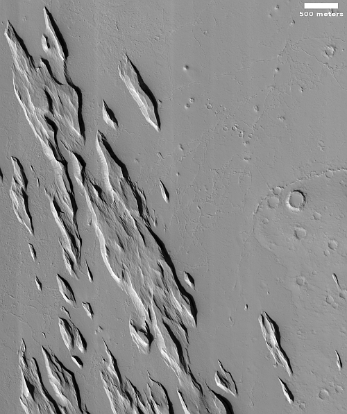
Pointy rocks on Mars

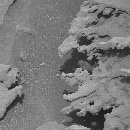
Pointy rocks as seen by Curiosity
Click for full image.

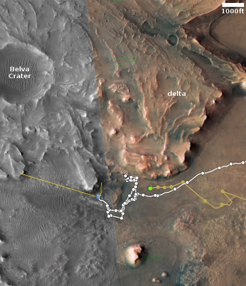
Pointy rocks as seen by Perseverance
Click for full image.

We have two cool images today from both of America’s rovers on Mars, each of which illustrates the alien nature of the red planet.

First on the right, cropped, reduced, and sharpened to post here, is a close-up taken by Curiosity’s high resolution camera on May 14, 2022 of the rightmost jagged boulder in yesterday’s navigation panorama. The number of layers is astonishing, though hardly a unique phenomenon as seen by Curiosity in its travels. Each likely marks one of many climate and geological cycles, each laying down another unique stratum for a relatively short period of geological time. Some might be volcanic ash or lava layers. Some might be layers caused by climatic changes.

The ability of these thin layers to extend outward so much, almost like they were floating, illustrates the weak Martian gravity, as well as the thinness of its atmosphere. On Earth, if the wind and weather didn’t cause these flakes to break, the gravity would.

Second on the right, cropped and sharpened to post here, is a high resolution photo taken by Perseverance on May 15, 2022 of one of the cliff faces seen by the rover looking up into the delta in Jezero Crater. Here again we see many layers and jagged, pointy rocks, illustrating again the many cycles in the past that formed the delta as it flowed into the crater.

The smoothness on the surface of the leftmost pointy rock suggests that it has stood in this position for a long very time, allowing the wind of Mars’ very thin atmosphere to erode its rough surface.

Curiosity climbs on!

Curiosity's view to the southeast, May 15, 2022 (Sol 3474)
Click for full resolution. Original images can be found here, here, and here.

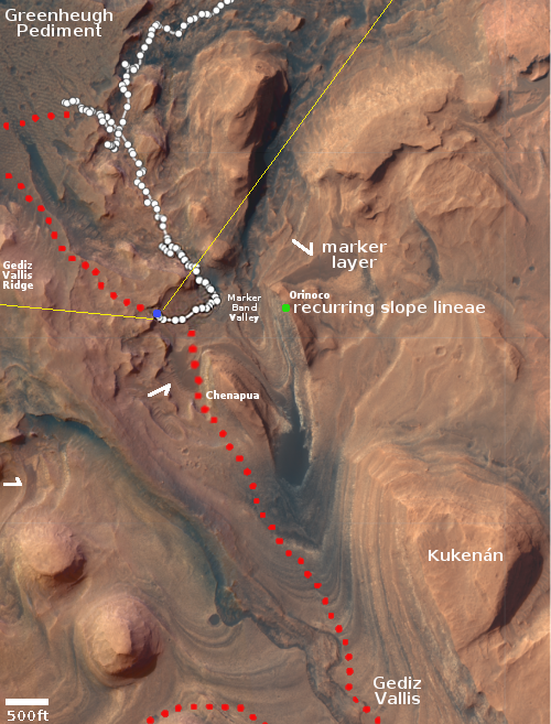
Overview map
Click for interactive map.

Cool image time! The panorama above, created from three photos taken on May 15, 2022 by the right navigation camera on Curiosity, shows the rocky and hilly terrain directly ahead of the rover’s present course. In the far distance in the center left can faintly be seen the lower flanks of Mount Sharp itself. The dust in the winter air acts to partly obscure those distant slopes.

The overview map to the right shows us what we are looking at. The yellow lines are my rough guess at the terrain covered by the panorama. The blue dot marks Curiosity’s present position. The red dotted line the rover’s original planned route. The white arrows indicate one of the more interesting upcoming geological features, dubbed by scientists the “marker horizon,” a distinct layer found in many places on the flanks of Mount Sharp.

The green dot marks the approximate location of a recurring slope lineae, a place where the cliff is seasonally darkened by a streak that appears each spring and then fades.

The navigation panorama taken on May 15th also included four more shots covering terrain to the southwest, so what we see above is not necessarily where the rover is heading. The eventual goal is to get back to that red dotted line, but how the rover does so is apparently still being discussed by the science team. It appears they are trying to decide whether to head west again to reach Gediz Vallis Ridge, or instead cut south heading directly for Gediz Vallis.

Either way, that teethlike row of boulders in the near foreground is certainly impressive.

Study: Russian astronauts on ISS have better techniques for protecting the brain

According to a study comparing the changes in the brain experienced during long term missions on ISS, it appears that the Russians have developed better protocols for preparing themselves for return to Earth that prevents the enlargement in one part of the brain seen in American astronauts.

From the link:

The study focused on 24 Americans, 13 Russians, and a small, unspecified number of astronauts from the ESA. The researchers collected MRI scans of the astronauts’ brains before and after they spent six months on the ISS (only 256 individuals have visited the space station).

After being in space, all the space travelers exhibited similar brain changes: cerebrospinal fluid buildup and reduced space between the brain and the surrounding membrane at the top of the head. The Americans, however, also had more enlargement in the regions of the brain that serve as a cleaning system during sleep, e.g. the perivascular space (PVS).

…The Russian astronauts did not exhibit enlarged PVS, suggesting there might be differences in protocol that are neuro-protective.

From the paper itself:

[Russian C]osmonauts undergo six lower body negative pressure (LBNP) sessions starting two weeks prior to landing, while NASA and ESA astronauts do not typically do it. LBNP induces caudal displacement of fluids from the upper body by placing the legs and pelvis in a semiairtight chamber with negative pressure.

An advanced resistive exercise device (ARED) is regularly used by space flyers to perform free weight exercises on the ISS, but the load and frequency of use are lower for [Russian] cosmonauts compared with NASA and ESA astronauts. Lifting heavy loads during resistive exercise is often accompanied by a brief Valsalva maneuver, inducing increased ICP and decreased cerebral blood flow and cerebrovascular transmural pressure, which can result in PVS fluid accumulation. Although the effects of LBNP and ARED on the brain during spaceflight are unknown, they could partly explain the different WM-PVS changes detected in astronauts and cosmonauts. We cannot exclude that other factors (e.g., diet) might play a role in this difference. Further studies are required to confirm these hypotheses.

Apparently two protocols are different that seem to help the Russians. First, the LBNP, developed by the Russians on their earlier space stations, is essentially a pair of pants that sucks fluids down to the legs, simulating the situation normally found on Earth, and thus reduces the fluids in the upper body sooner than landing. Second, doing exercises simulating lower weight loads apparently helps the Russians as well.

Scientists grow plants in lunar soil brought by from Apollo missions

In their first attempt, scientists have successfully grown plants in a small lunar soil sample brought by astronauts during the Apollo missions.

Researchers at the University of Florida had spent 11 years requesting permission from Nasa to borrow some of the lunar dust brought back by astronauts on the first manned Apollo 11 and Apollo 12 missions in 1969 and the Apollo 17 mission in 1972. Armstrong and Aldrin brought back 21.6kg of material including 50 rocks, samples of dust and two cores of rock after boring 13cm down into the Moon’s surface. They contained no water and no signs of life.

…The lunar samples are deemed to be of “incalculable historical and scientific significance”, so the scientists were given only 12 grams, just a few teaspoons’ full, to work with and had to design a miniature experiment.

The researchers used thimble-sized wells in a dish usually used for growing cells as miniature plant pots and filled each with about one gram of lunar soil. They moistened the soil with water and a solution of nutrients and added a small number of seeds from the Arabidopsis thaliana plant, a common flowering weed also known as mouse-ear or thale cress. [emphasis mine]

The plants grew, but were smaller and took longer to grow then plants on even the most extreme environments on Earth. The scientists also found that plants did better in buried lunar soil then the material on the surface that had been exposed to the harsh radiation of space, suggesting that plowing the soil before planting will enhance growth.

The highlighted words in the quote above illustrate the madness of NASA’s bureaucracy. These lunar samples were brought back so that scientists could study it, not so that it could be locked away in a vault forever never to be touched. To make this very intelligence experiment wait 11 years before getting permission is absurd.

First radio image of event horizon of Milky Way’s central black hole

Sagittarius A*
Click for full image.

Using an array of eight radio telescopes worldwide, dubbed the Event Horizon Telescope because its purpose is to study black holes, scientists have obtained the first radio image of the event horizon of Sagittarius A* (pronounced “A-star”), the supermassive black hole at the center of the Milky Way.

The image to the right, reduced to post here, is that photo.

The image is a long-anticipated look at the massive object that sits at the very centre of our galaxy. Scientists had previously seen stars orbiting around something invisible, compact, and very massive at the centre of the Milky Way. This strongly suggested that this object — known as Sagittarius A* (Sgr A*, pronounced “sadge-ay-star”) — is a black hole, and today’s image provides the first direct visual evidence of it.

Although we cannot see the black hole itself, because it is completely dark, glowing gas around it reveals a telltale signature: a dark central region (called a “shadow”) surrounded by a bright ring-like structure. The new view captures light bent by the powerful gravity of the black hole, which is four million times more massive than our Sun.

This is the second supermassive black hole that the Event Horizon array has imaged. In 2019 it captured the central black hole of the galaxy M87, 55 million light years away. Like that first image, much of what we see here is created by computer, since the data from the eight radio telescopes needs to be massaged to create something as smooth and as complete as this.

Mountains, Mesas, and Box Canyons on the floor of Valles Marineris

Mountains, Mesas, and Box Canyons
Click for full image.

Overview map

Cool image time! The photo above, cropped, reduced, and rotated to post here, was taken on March 12, 2022 by the high resolution camera on Mars Reconnaissance Orbiter (MRO). It shows a small section of the floor of the giant 2,550-mile-long and 400-mile-wide Valles Marineris canyon on Mars. In fact, this section, as indicated by the black rectangle in the overview map below, is practically in the center of the canyon, at its widest point.

The geology here hints at several Martian processes. The mesas and closed canyons in the north are typical of chaos terrain, where it erosion appears to form along fault lines to create the random intersecting canyons. In other places on Mars, in the mid-latitudes, that erosion appears mostly formed by glacial activity. Here, in Valles Marineris at only 7 degrees north latitude, little ice had been expected.

However, this spot is also in the dead center of a region where orbital data from Europe’s Trace Gas Orbiter (TGO) suggests there is a surprisingly large underground reservoir of hydrogen, which is assumed could only exist if it was locked in water molecules.

In fact, at this spot the data suggests up to 40% of the near-surface material might be composed of water (by weight). If so, that underground reservoir of ice could be causing the erosion that is creating this massive chaos terrain.

Meanwhile, the light-colored mountain in the south is the westernmost nose of a 50-mile-long ridgeline coming down from the canyon’s rim, about 30,000 feet higher. Its dendritic nature, like the hollows that form in the mountains of wet regions on Earth, suggest rainfall and water flowing downhill, wearing away these hollows over eons.

Rain however is almost certainly not the cause. Instead, we could be seeing erosion from wind, or maybe dry ice snow that fell long ago when this region was at a higher latitude when Mars’ rotational tilt was different.

Either way, the massive geology here illustrates the monumental nature of this largest canyon in the solar system, as well as the difficulties of exploring it.

The evidence keeps pouring in showing the utter failure of all COVID mandates

Since March 2020 I have repeatedly written that the response to the Wuhan flu was an utter mindless panic that had little to do with the facts. Right off the bat, the facts, not the models, suggested the virus would resemble the flu most of all, a possible mortal threat to the sick and elderly but generally nothing more than a short sickness to the general population, with it being almost utterly harmless to the young.

Nothing that has happened since has really changed these early conclusions. I have compiled below a collection of recent studies and reports that illustrate what we have learned following the epidemic and the panic that accompanied it. Sadly, that panic did little to stop the virus, but it left us with destroyed businesses, a crushed economy, many uneducated and damaged children, and a broken Bill of Rights.

The COVID jab

The failure of the jab in the United Kingdom
Study from November 2021showing the overall uselessness of the jab
in the United Kingdom last year.

The first set of stories show some recent studies analyzing the effectiveness and safety of the COVID shots, which are not vaccines because they simply do not prevent you from getting the virus. At best — though not yet proven — they might reduce the severity of the disease should you get it. The data however now suggests that though the overall risks are not large, the jab carries enough risk that in many cases, it makes no sense to get it. To require it, as many governments and businesses have done, is downright stupid and immoral. To fire nurses and doctors for refusing the shots is beyond stupid or immoral. It is evil.

Worse, these facts were known right from the initial tests, as the last story below shows. In the company’s initial trials they found that 1,223 people died within the first 28 days after taking the Pfizer shot. Such a result in past drug trials would have made impossible the approval of that drug.
» Read more

Scientists propose new theory to explain mysterious slope streaks on Mars

Slope streaks on Mars
Click for full image.

In a paper published earlier this month, scientists have proposed a new theory to explain the the origin of slope streaks on Mars, a unique Martian geological feature that at first glance look like a stainlike avalanches which also appear to do nothing to change the surface topography. (See earlier posts here and here for a description of this strange Martian phenomenon.)

Essentially, data from the orbiters suggests that carbon dioxide frost develops just under the surface during the night. In equatorial regions this frost mixes with dust (allowing it to exist even in these warmer climates). When the morning light hits the frost it causes it to sublimate away, which in turn causes the appearance of slope streaks as the dust is released from the frost.

From the paper’s abstract:

At sunrise, sublimation-driven winds within the regolith are occasionally strong enough to displace individual dust grains, initiating and sustaining dust avalanches on steep slopes, forming ground features known as slope streaks. This model suggests that the CO2 frost cycle is an active geomorphological agent at all latitudes and not just at high or polar latitudes, and possibly a key factor maintaining mobile dust reservoirs at the surface.

The cool image above, cropped and reduced to post here, was taken on October 28, 2020 by the high resolution camera on Mars Reconnaissance Orbiter (MRO) and shows an excellent example of two very spectacular large slope streaks, one long and narrow and another short and wide. Located at 23 degrees, this is an area where no ice has yet been found near the surface.

This new theory joins two other popular theories attempting to explain slope streaks. The others postulate that the streaks are either dust avalanches of a different type or the percolation of a brine of chloride and/or perchlorate in a thin layer several inches thick close to the surface.

None have been proven. None likely fit all the known data at this point.

CAPSTONE Moon satellite shipped to New Zealand by Terran Orbital

Capitalism in space: Terran Orbital has completed construction of the CAPSTONE Moon smallsat and has now had it shipped to New Zealand for its launch on a Rocket Lab Electron rocket no earlier than May 27th.

Tyvak Nano-Satellite Systems, a Terran Orbital Corporation, built the spacecraft for the Cislunar Autonomous Positioning System Technology Operations and Navigation Experiment, otherwise known as CAPSTONE. The 12U CubeSat includes a radio tower on top that extends its size from a traditional 12U form factor.

CAPSTONE will not go directly to the Moon but instead, follow a “ballistic lunar transfer” that will take it out as far as 1.5 million kilometers before returning into lunar orbit. That transfer, which will take about four months to complete, is designed to save propellant, making the mission feasible for such a small spacecraft. The CAPSTONE payload and its software are owned and operated by Advanced Space for NASA.

CAPSTONE will use Rocket Lab’s Proton upper stage to get it to the Moon. It will then test maneuvering as well as communicating in the lunar halo orbit that NASA wants to use with its Lunar Gateway space station. It will also be proving out the use of this kind of smallsat for future interplanetary missions.

InSight detects 5 magnitude Martian quake, the largest detected so far

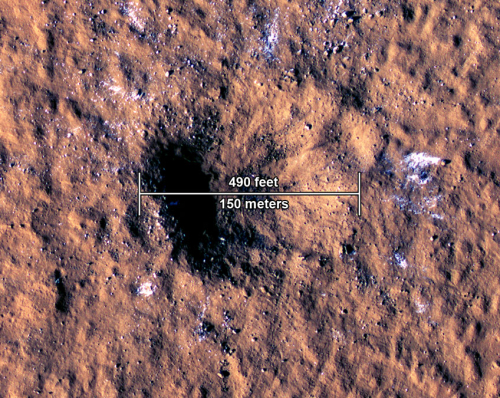
The seismometer deployed by the Martian lander InSight has now detected its largest quake yet on Mars, with an estimated magnitude of 5.

NASA’s InSight Mars lander has detected the largest quake ever observed on another planet: an estimated magnitude 5 temblor that occurred on May 4, 2022, the 1,222nd Martian day, or sol, of the mission. This adds to the catalog of more than 1,313 quakes InSight has detected since landing on Mars in November 2018. The largest previously recorded quake was an estimated magnitude 4.2 detected Aug. 25, 2021.

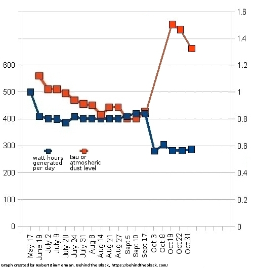
The timing was very fortunate. Only three days later the power being generated by InSight’s dust-covered solar panels dropped too low, and the lander went into safe mode. Though its mission has been extended through the end of this year, the inability of the solar panels to produce energy because of dust has been predicted to shut down operations sooner. While it might be possible to restart science operations, this most recent safe mode situation could very well be that moment.

Meanwhile, scientists will analyze the data of this most recent large quake to attempt to pinpoint its location. They will also study it to gain a better understanding of the interior structure of Mars.

China releases to the public some of the datasets from the Chang’e-5 lunar mission

China announced today that it has made available to the public the data from some of the instruments that flew on its November 2020 Chang’e-5 sample return lunar mission.

The instruments involved were the mission’s landing camera, panoramic camera, lunar mineralogical spectrometer, and regolith penetrating radar.

The data is supposedly available here, but you have to be able to read Chinese to find it.

Why a big Earth mountain would hardly be noticed on Mars

A big mountain lost on Mars
Click for full image.

Cool image time! The photo to the right, cropped and reduced to post here, was taken on February 13, 2022 by the high resolution camera on Mars Reconnaissance Orbiter (MRO). It shows a cliff escarpment that, based on a rough estimate of MRO’s elevation data, ranges from 10,000 to 13,000 feet high. Because the sun is only about 32 degrees above the western horizon, the shadows are long and distinct and bring out the features quite dramatically.

On Earth, a mountain 13,000 feet high would generally be named, because there are really not that many of them. If it was a cliff face dropping down into a canyon, which this Martian cliff is, it would be quite unique and probably be one of the most popular tourist spots on the globe. For comparison, the rim of the Grand Canyon in the national park, visited by millions, is only 4,000 to 6000 feet in elevation. This cliff on Mars is more than twice as deep, and yet, it is hardly the most spectacular canyon rim on the red planet.

The overview map below explains this.
» Read more

Lunar samples from Chang’e-5 confirm fuel and oxygen can be mined from surface

Chinese scientists studying the lunar samples returned by Chang’e-5 probe have confirmed earlier studies of Apollo lunar samples that it is possible to extract oxygen and fuel from the Moon’s soil.

After analyzing the Chang’e-5 lunar soil, the team found the sample contains iron-rich and titanium-rich substances, which could work as a catalyst to make oxygen using sunlight and carbon dioxide.

The team proposed a strategy using lunar soil to electrolyze water from the moon and the astronauts’ life support system into oxygen and hydrogen. The process is powered by sunlight. The carbon dioxide exhaled by moon inhabitants can be collected and combined with hydrogen to yield the fuel methane, also catalyzed by lunar soil, according to the study. With this method, no external energy apart from sunlight would be used to produce oxygen and fuel to support life on a moon base, said the researchers.

What is new about these results are the proposed techniques and components used to make the process practical. The science team is now proposing testing it on future Chinese Moon missions

Citizens enlisted to find changes to Comet 67P/C-G during Rosetta mission

The European Space Agency (ESA) and Zooniverse have partnered to create a new citizen science project, allowing anyone to more easily review the archive of high resolution photos taken by Rosetta of Comet 67P/C-G and look for changes that occurred during the probe’s mission to the comet.

“The Rosetta archive, which is openly accessible to scientists and the public, contains a vast amount of data collected by this extraordinary mission that have only been partially explored,” says Bruno Merín, head of ESA’s ESAC Science Data Centre near Madrid, Spain. “In the past few years, astrophotographers and space enthusiasts have spontaneously identified changes and signs of activity in Rosetta’s images. Except for a few cases, though, it has not been possible to link any of these events to surface changes, mostly due to the lack of human eyes sifting through the whole dataset. We definitely need more eyes!”

This is why ESA partnered with the Zooniverse, the world’s largest and most popular platform for people-powered research. The new Rosetta Zoo project presents a particular set of data: pairs of images collected by Rosetta’s OSIRIS camera showing Comet 67P’s surface before and after perihelion.

Volunteers are invited to view images of roughly the same region side by side and identify a variety of changes, from large-scale dust transport to comet chunks that moved or even vanished. Sometimes this may require zooming in or out a few times, or rotating the images to spot changes on different scales, getting up close and personal with the iconic comet.

Using Rosetta Zoo will require no software, nor will anyone need to register to use it. You simply go to the website and begin comparing pairs of images, for as long as you wish, marking differences you spot of the same locations.

A quake south of Starship’s prime landing sites on Mars

The lowlands south of Starship's prime landing site
Click for full image.

Cool image time! The photo to the right, rotated, cropped, and reduced to post here, was taken on February 23, 2022 by the high resolution camera on Mars Reconnaissance Orbiter (MRO). Though it shows the largely featureless northern lowland plains of Mars, it is particularly interesting for two reasons.

First, according to the photo’s label this scarp/ridge is apparently near a quake detected by the seismometer placed on Mars by the lander InSight, located about a thousand miles to the southwest. Though no information of the strength of this quake is available, it is likely to have been a small and weak one, interesting mostly because it indicates some small underground instability or a recent small impact on the surface. The image favors the former, as it shows no obvious recent features of change. What it does show is one very intriguing flow feature draping the scarp. As the location is at 34 north latitude in a region where scientists have found a lot of evidence of water ice very close to the surface, the flow could very well be glacial in nature, though dismissing a lava origin would be a mistake.

The second reason this location is of interest is what lies relatively nearby, as shown in the overview map below.
» Read more

ESA: ExoMars will likely be delayed till ’28 at the soonest

An official of the European Space Agency (ESA) at a May 3rd science meeting announced that the launch of its ExoMars rover will likely be delayed until 2028 at the earliest because of the partnership breakup with Russia due to its invasion of the Ukraine.

Russia had been providing both the launch rocket as well as the lander on Mars.

Speaking at a May 3 meeting of NASA’s Mars Exploration Program Analysis Group (MEPAG), Jorge Vago, ExoMars project scientist at ESA, said he doubted a new lander could be ready by 2026. “It is theoretically possible, but in practice we think it would be very difficult to reconfigure ourselves and produce our own lander for 2026,” he said. “Realistically, we would be looking at a launch in 2028.”

Launching in 2028 could pose technical challenges for ExoMars. One trajectory would get the rover to Mars relatively quickly, but have it arrive just a month before dust storm seasons starts at the preferred landing site. An alternative trajectory would require traveling for more than two years to each Mars, but get the rover there six months before dust storms start.

“We have been trying very hard to convince the engineering team that the dust storm season is not death,” Vago said. “We should concentrate on making the rover more robust and able to weather a dust storm.”

There are other issues. The rover will need new radioisotope heating units, or RHUs, to provide power, since Russia will no longer providing them. If the U.S. provides, the launch for security reasons will have to take place in the U.S., which means the launch provider will have to be American.

The delay to ’28 also could cause the ExoMars rover mission to be completely changed, repurposed to become part of the sample return mission that the ESA and NASA are partnering to bring back the cached samples that Perseverance is gathering. If so, this repurposing might delay its launch to Mars even further.

Zhurong travels another 1,300 feet

Overview map

UPDATE: After emailing this post to Alfred McEwen of the Lunar & Planetary Laboratory in Arizona, he responded to correct an error in my image. The MRO photo was taken when Zhurong had already traveled about half the 1,300 feet listed in the Chinese article below, thus making my original circle about two times too large.

I have corrected its size. It now shows the correct maximum distance Zhurong could have driven since that MRO picture was taken on March 11th.

Original post:
——————–
According to a short report yesterday in China’s state-run press, Zhurong has traveled another 1,300 feet on Mars since it was photographed from orbit on March 11, 2022 by the high resolution camera on Mars Reconnaissance Orbiter (MRO).

The report provided no information at all about the rover’s path. The map to the right shows Zhurong’s position as of March 11th, with the blue circle marking the maximum distance it could have moved since then according to this report. Based on China’s earlier vague statements, it is likely the rover has moved to the south, though even that covers a lot of possibilities.

The report did say this however:

Mars is about to enter the winter season, during which night temperatures will drop below minus 100 degrees Celsius, with a high probability of sandstorms. Martian winters last an equivalent of six Earth months.

Because Zhurong uses solar panels, it relies on the Sun for power. With coming of winter and more sandstorms, it thus faces the risk of limited solar power. As its nominal mission was only supposed to last three months, not a Martian year of 24 months that includes a winter, it will be interesting to see if it can survive that season.

The story also added that Yutu-2 has now traveled about 3,875 feet on the Moon, but added nothing else.

Navigating a rover on Mars

16 photos taken by Perseverance's right navigation camera on May 2, 2022

Overview map
Click for interactive map.

Cool image time! The photo to the right is actually a screen capture of 16 consecutive photos taken on May 2, 2022 by the right navigation camera on the Mars rover Perseverance.

The overview map below gives the context. The red dot marks Perseverance’s position when the photos were taken. The green dot marks Ingenuity’s position. The small white dot marks the spot where the rover’s parachute landed. The yellow lines indicate I think the area covered by the sixteen navigation images.

There is a reason for showing this panorama in this somewhat crude form. The engineers who run Perseverance have programmed its navigation cameras to send back its pictures so that they immediately line up in this coherent pattern. There is no need to rearrange them upon arrival. The engineers thus can instantly see how each picture relates to the others, and thus get an immediate sense of the nearby terrain in which they must plot the rover’s next move.

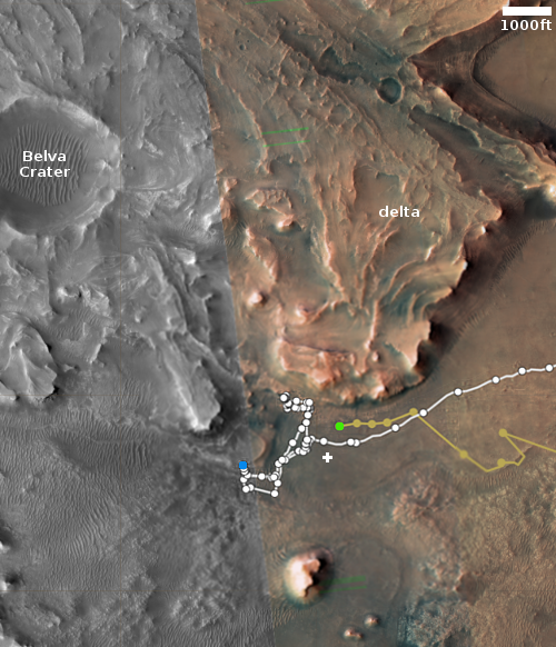
Perseverance is now in its second science campaign, focused on studying the base of the delta. As the science team studies the delta’s cliff face, they are also studying the best route to continue uphill. To do both, they have begun slowly moving along that face, going from west to east.

The rough panorama above thus shows them the ground ahead as they continue that traverse. I expect the rover’s next move will be to the northeast, once again moving along the base of the nearest cliff. The panorama shows that while the ground in this area has a few ridges, none are so high as to cause Perseverance any problems.

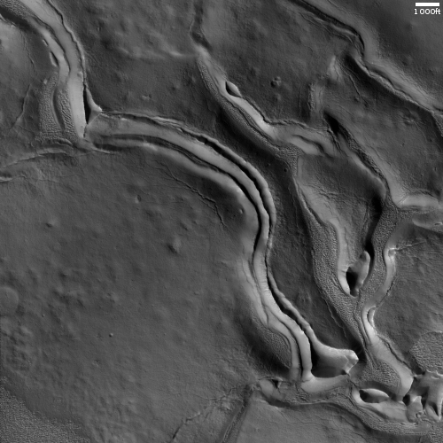
Brain terrain in Mars’ glacier country

Brain terrain in glacier country
Click for full image.

Cool image time! The photo to the right, cropped and reduced to post here, was taken on February 10, 2022 by the high resolution camera on Mars Reconnaissance Orbiter (MRO).

It shows what planetary scientists have dubbed “brain terrain”, a truly unique Martian geological feature that is not found on Earth and also remains as yet unexplained. Specifically, the brain terrain is the speckled areas between the larger flow features, all of which are probably ice or glacier related.

What especially drew me to this MRO image however was the particular flow feature in the center left that looks like either a giant squid or something out of Lovecraft horror short story. Talk about a cool image!

The downward grade here is likely to the north, as this spot is inside a north-south canyon, cutting into the southern cratered highlands. The general north-south trend of the depression here reinforce this supposition.

The overview image below provides context.
» Read more

NASA decides to end airborne SOFIA telescope operations

According to a joint announcement yesterday from NASA and the German space agency DLR, all operations of the airborne astronomy telescope SOFIA will end as of September ’22.

NASA has been trying to cancel this project for several years, because its capabilities have not justified its expense, about $85 million per year. Congress has repeatedly refused to go along, reinserting funding after NASA tried to delete it. That the astronomy community itself suggested in November that the project be canceled, however, probably means this Congress will likely go along with this most recent announcement.

Rogozin: Expect delays for future Russian lunar probes

China/Russian Lunar base roadmap
The so-called Chinese-Russian partnership to explore
the Moon.

According to a statement by Dmitry Rogozin, head of Roscosmos, yesterday in the Russian state-run press, the launch of two unmanned probes to the Moon, Luna-26 and Luna-27, are likely to be postponed due to “the current circumstances.”

“As for the Luna-26 lunar orbiter and the Luna-27 heavy lander mission, possibly, it will be adjusted taking into account that in the current situation we will be spending the main financial and industrial resources on increasing the orbital group. Now it is more important,” the space chief emphasized.

The Roscosmos CEO also asked for understanding if the mission is postponed. “Science is very important but now we are talking about the viability of Russia’s orbital group, about bringing it to a new level, its work as a group of double and military designation. Yet we are not postponing the lunar missions for long,” he added.

Rogozin added that Luna-25, scheduled for launch this year, has not been postponed.

Apparently the more than $1 billion of income that Roscosmos has lost by its refusal to launch OneWeb’s satellites is forcing it to make choices. For the government, the priority has to be launching communications, weather, navigation, and military surveillance satellites. Being tight on cash, Rogozin thus has no recourse but to favor those launches over any purely science missions.

This decision also demonstrates that Russia’s so-called partnership with China to explore the Moon, as shown in the graphic to the right that was released by China and Russia in June 2021, is pure hogwash. as I noted then:

Of the three Russian missions, Luna 25 is scheduled to launch later this year, making it the first all-Russian-built planetary mission in years and the first back to the Moon since the 1970s. The other two Russian probes [Luna-26 and Luna-27] are supposedly under development, but based on Russia’s recent track record in the past two decades for promised space projects, we have no guarantee they will fly as scheduled, or even fly at all.

Rogozin also said yesterday that he plans further talks with China in May to further their partnership concerning lunar exploration and building a lunar base. Let me translate: “We need cash to launch anything, and hope the Chinese will provide some.”

As Curiosity retreats from rough country, scientists look at the future geology it will see

Overview map
Click for interactive map.

Cool image time! For the past two weeks the Curiosity science team has been gingerly and slowing backing the rover off from the very rough terrain of the Greenheugh pediment, as shown on the overview map to the right. The blue dot indicates Curiosity’s present position, with the red dotted line marking its original planned route, now abandoned.

The main question remains: Where to go next? At this point the science team is still debating their exact path forward. As Catherine Weitz of the Planetary Science Institute explained to me in an email today,

The Curiosity team is still working out the details. Maybe in another month or so the new route will be finalized so stay tuned.

No matter what route they eventually choose, the white arrows mark one of the more interesting upcoming geological features that the scientists very much intend Curiosity to reach. In a paper published at the end of March in which Weitz was the lead author, they describe this “marker horizon” as follows:
» Read more

Dunes on Jupiter’s volcano moon Io?

Dunes on Io?
Click for full image.

The uncertainty of science: According to a just published paper, scientists now propose that the dune-like ridges long known to exist on Io, Jupiter’s volcano-covered moon, might actually be dunes, even though Io has no real atmosphere.

The photo to the right, cropped, reduced, and annotated to post here, was taken by the Galileo while it orbited Jupiter from 1995 to 2003. It illustrates what the scientists believe is the proposed process:

McDonald and his colleagues used mathematical equations to simulate the force required to move grains on Io and calculated the path those grains would take. The study simulated the movement of a single grain of basalt or frost, revealing that the interaction between flowing lava and sulfur dioxide beneath the moon’s surface creates venting that is dense and fast moving enough to form large dune-like features on the moon’s surface, according to the statement.

In what might be a monumental understatement about the reality of interplanetary geology, McDonald said this in the press release: “This work tells us that the environments in which dunes are found are considerably more varied than the classical, endless desert landscapes on parts of Earth.”

Damn right. The possibility of unexpected geology of all kinds on the millions of planets, moon, and asteroids not yet studied is endless, and guaranteed.

Ingenuity photographs Perseverance’s abandoned parachute on 26th flight

Perseverance's parachute, as photographed by Ingenuity
Click for full image.

Overview map
Click for interactive map.

In the past week the Mars helicopter Ingenuity successfully completed its 26th and 27th flights, with the first specifically planned to fly over the parachute that had been used by Perseverance when it landed on Mars on February 18, 2021. The first photo to the right, enhanced, cropped, and reduced to post here, is the color photo of that parachute that Ingenuity took during that flight on April 20th. Near the top of the frame you can also see the equipment used to attach the chute to the rover. The photo looks to the southwest.

The map to the right indicates the flight paths for both hops, both slightly more than 1,000 feet total. The green dot marks Ingenuity’s position yesterday, the red dot Perseverance’s position. The small white dot indicates the parachute’s location.

On April 8th Perseverance had snapped a picture of the parachute, from the position indicated by the black dot. Since that photo was taken from a distance, it could not show much. Ingenuity’s more recent photo from overhead however captures the chute quite clearly, and suggests that in the year since landing the weak Martian wind has shifted its edges slightly while depositing some dust on its surface.

You can see the changes at the edges by comparing Ingenuity’s picture with a photo taken on February 19, 2021 by Mars Reconnaissance Orbiter (MRO). In Ingenuity’s picture the near edge of the parachute especially appears to have become bunched up over time, suggesting the prevailing and strongest winds have come from the south.

InSight scientists publish paper describing last year’s big Martian quakes

Figure 5: global map of located Martian quakes

The InSight science team has now published a paper [pdf] describing in detail what they gleaned from the two large earthquakes the lander detected on Mars last year, measuring 4.1 and 4.2 magnitudes.

The map above, figure 5 of their paper, marks their best estimate of the quakes’ locations, dubbed S0976a and S1000a. From the caption:

Mars surface relief map showing InSight’s location (orange triangle), the location of other located mars-quakes (magenta dots) that cluster around 30° distance, close to Cerberus Fossae, and S0976a, located within Valles Marineris just north of Sollis Planum. Because no back azimuth can be determined for S1000a, its location is predicted to be somewhere within the shaded region between 107° and 147° from InSight. The event’s preferred distance (116°) is marked with the white dashed line. The black dotted lines mark radii around InSight up to 80°.

A review of Mars Reconnaissance Orbiter (MRO) high resolution images of that part of Valles Marineris where S096a occurred will likely uncover a whole bunch taken since last August, all attempting to detect any actual surface changes produced by quake. I think I’ll do that review, and see if I can spot something.

The paper also notes the uniqueness of S1000a, which lasted 94 minutes, the longest so far detected on Mars. The complexity of its signal also makes locating it difficult, though the most likely possible locations — indicated by the white dashed line in the map above — crosses through the Tharsis Bulge where Mars’ biggest volcanoes are found.

Sadly, InSight will likely shut down before the end of this year due to loss of power, so until another seismometer is sent there no further Martian quakes will be detected.

NASA extends eight planetary missions, including sending OSIRIS-REx to the asteroid Apophis

Apophis' path past the Earth in 2029
Apophis’ path past the Earth in 2029.

NASA today announced that it is extending the missions of eight different planetary probes.

The missions – Mars Odyssey, Mars Reconnaissance Orbiter, MAVEN, Mars Science Laboratory (Curiosity rover), InSight lander, Lunar Reconnaissance Orbiter, OSIRIS-REx, and New Horizons – have been selected for continuation, assuming their spacecraft remain healthy. Most of the missions will be extended for three years; however, OSIRIS-REx will be continued for nine years in order to reach a new destination, and InSight will be continued until the end of 2022, unless the spacecraft’s electrical power allows for longer operations.

The biggest news is the decision to extend OSIRS-REx so that it can rendezvous with the asteroid Apophis in 2029. The science team…

…will redirect the spacecraft to encounter Apophis, an asteroid roughly 1,200 feet (roughly 370 meters) in diameter that will come within 20,000 miles (32,000 kilometers) of Earth in 2029. OSIRIS-APEX will enter orbit around Apophis soon after the asteroid’s Earth flyby, providing an unprecedented close-up look at this S-type asteroid. It plans to study changes in the asteroid caused by its close flyby of Earth and use the spacecraft’s gas thrusters to attempt to dislodge and study the dust and small rocks on and below Apophis’ surface.

Apophis is a potentially dangerous asteroid, with a 1 in 150,000 chance it will hit the Earth in 2068. Getting as much information about it as soon as possible is crucial so that future generations will be prepared should its path eventually become a collision course.

The icy Reull Valley of Mars

Eroded ice in crater near Reull Valles
Click for full image.

Cool image time! The photo to the right, cropped and reduced to post here, was taken on February 20, 2022 by the high resolution camera on Mars Reconnaissance Orbiter (MRO). It shows the eroded floor of a 10-mile-wide very obscured unnamed crater that sits above the northern wall of a canyon dubbed Reull Valles.

For reference the interior slope of the crater’s southern rim is labelled. The crater sits at 40 degrees south latitude. Thus, this crater is inside the 30 to 60 degree mid-latitude bands where scientists have found many glaciers on Mars. The eroded floor of this crater appears to confirm this conclusion. In the full photo the erosion is even more pronounced, as well as more chaotic, farther from that rim to the north.

Because Reull Valles sits inside that southern glacial band, it is home to much evidence of ice. The overview map below provides the context.
» Read more

1 59 60 61 62 63 277