Ispace secures first insurance deal for private lunar lander

Capitalism in space: The Japanese startup Ispace has now obtained the first insurance plan ever for a private lunar lander.

The startup has signed a Memorandum of Understanding with Mitsui Sumitomo Insurance (MSI), a Tokyo-based firm that started working with Ispace in 2019, to insure its first attempt to send a lander to the moon later this year. The agreement outlines intentions to finalize terms for the insurance in the months leading up to Ispace’s Mission 1 (M1), which is currently slated to fly on a Falcon 9 rocket no earlier than the fourth quarter of 2022.

According to Ispace, the insurance would cover any damage the lander takes between separating from the rocket in a trans-lunar orbit (TLO) and touching down on the moon. As well as covering a failed landing, the insurance would guard against issues stemming from radiation exposure as the lander travels through the Van Allen belts to its destination.

The insurance does not cover the payloads Ispace’s lander will carry, including a rover from the United Arab Emirates.

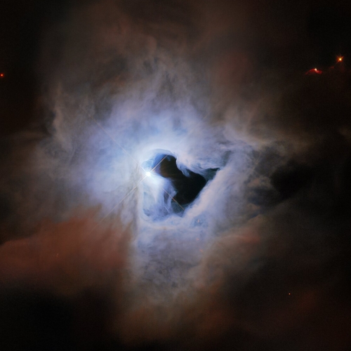
Colliding galaxies

Merging galaxies

The string of amazing galaxy images coming from the Hubble Space Telescope continues. The photo to the right, cropped and reduced to post here, was released today and shows an object dubbed VV-689 that is believed to be two galaxies in the process of colliding and merging.

The angelic image comes from a set of Hubble observations that took a closer look at “Zoo Gems,” interesting galaxies from the Galaxy Zoo citizen science project. This crowdsourced program relies on hundreds of thousands of volunteers to classify galaxies and help astronomers wade through a deluge of data from robotic telescopes. In the process, volunteers discovered a gallery of weird and wonderful galaxy types, some not previously studied.

This image will lay the groundwork for more detailed research. Right now it appears no one has even estimated its distance.

The gigantic lava flows off of the solar system’s biggest known volcano

Olympus Mons' gigantic lava flow
Click for full image.

Cool image time! The photo to the right, cropped, reduced, and annotated to post here, was taken on October 30, 2021 by the high resolution camera on Mars Reconnaissance Orbiter (MRO). The picture covers a very tiny section of the southeast flank of Olympus Mons, the largest known volcano in the solar system. The arrow indicates the direction of the downward slope.

Olympus Mons itself is about 400 miles wide with an actual height relative to Mars’ “sea level” of just under 70,000 feet, more than twice as high as Mount Everest on Earth. The mountain’s flanks, almost 200 miles long from caldera edge to base, drop about 54,000 feet. That average drop of about 270 feet every mile is not particular steep, but its continuous nature over such a very very long distance makes its quite daunting.

You can see evidence of that slope in the photo. The downward pointing lobes each indicate the volcano’s last separate lava flows that ceased moving when each froze in place, probably several tens of millions of years ago. These lobes were also placed on top of many earlier flows from the volcano’s past eruptions that probably continued for several billion years, beginning 3.5 billion years ago.

The overview map helps provide a sense of scale by placing this image on that mountain flank.
» Read more

Lucy team schedules attempt to complete solar panel deployment

Lucy solar panel graphic
Artist’s impression of solar panel

After months of discussions, the engineering team of the Lucy asteroid probe have now scheduled the week of May 9th as when they will begin their attempt to complete the deployment of the spacecraft’ partly opened solar panel.

The team is now preparing to complete the solar array deployment in two steps. The first step, tentatively scheduled for the week of May 9, is intended to pull in most of the remaining lanyard and verify that flight results are consistent with ground testing. This step will also strengthen the array by bringing it closer to a fully tensioned state. Because this step is designed to be limited in duration, the array is not likely to latch at that point.

If this step goes as planned, the second step will continue the array deployment with the intent to fully latch. Information gleaned from the first part will help fine-tune the second. The second step is currently planned for a month after the initial one, giving engineers enough time to analyze the data seen in the first attempt.

When launched in October 2021 one of Lucy’s two large solar panels did not completely open and latch, as shown above. Though the spacecraft is presently getting 90% of its expected power, the scientists want to get the panel fully open and latched to insure it will function as planned once the spacecraft gets out to the asteroid belt, where sunlight is dimmer.

Astronomers discover new type of stellar explosion

Using data from the orbiting TESS observatory and the ground-based Very Large Telescope (VLT) in Chile, astronomers have detected evidence of a new type of stellar explosion they have dubbed a “micronova.”

The micronova appears to be a smaller version of a nova, which brightens the entire star for a month or so.

A white dwarf in a two-star system can steal material, mostly hydrogen, from its companion star if they are close enough together. As this gas falls onto the very hot surface of the white dwarf star, it triggers the hydrogen atoms to fuse into helium explosively. In novae, these thermonuclear explosions occur over the entire stellar surface. “Such detonations make the entire surface of the white dwarf burn and shine brightly for several weeks,” explains co-author Nathalie Degenaar, an astronomer at the University of Amsterdam, the Netherlands.

Micronovae are similar explosions that are smaller in scale and faster, lasting just several hours. They occur on some white dwarfs with strong magnetic fields, which funnel material towards the star’s magnetic poles. “For the first time, we have now seen that hydrogen fusion can also happen in a localised way. The hydrogen fuel can be contained at the base of the magnetic poles of some white dwarfs, so that fusion only happens at these magnetic poles,” says Paul Groot, an astronomer at Radboud University in the Netherlands and co-author of the study.

What this discover really reveals is that as our astronomical observing technology improves, we can observe a greater variety of stellar phenomenon. Expect astronomers in future years to detect an even wider variety of stellar explosions, most of which have not be detectable up until now because we simply couldn’t see them.

Astrobotics unveils nearly complete Peregrine lunar lander

Capitalism in space: Astrobotics yesterday unveiled its nearly complete Peregrine lunar lander, scheduled for launch later this year on the first launch of ULA’s new Vulcan rocket.

The lander is still being assembled, said John Thornton, chief executive of Astrobotic. Remaining work includes installation of its solar panels, two fuel tanks and decks holding payloads. The engines are “just about done,” he said, and will soon be installed.

He was optimistic that remaining work will be done quickly. “In just a couple months’ time, this will be heading out to environmental testing,” he said, followed by shipment to the launch site late this year.

This announcement now strongly suggests that Peregrine would not have been ready for Vulcan’s original launch date in late 2021. Since then the delays by Blue Origin in developing Vulcan’s first stage BE-4 engine has pushed the rocket’s first launch back by more than a year, time that apparently Astrobotics needed to finish Peregrine.

Perseverance captures solar eclipse by Phobos

Phobos eclipse the Sun
Click for full image.

Cool movie time! The photo to the right, cropped to post here, shows the Sun partly blocked by the Mars’ moon Phobos, taken by the high resolution camera on Perseverance on the surface of Mars. Below I have embedded the full movie compiled from the images taken as Phobos moved across the Sun’s face. From the caption:

It’s long been known that Phobos is drifting toward the Martian surface year by year; tens of millions of years from now, it is expected to crash into the planet or fragment into chunks that will impact the planet. Studying Phobos’ orbit also allows scientists to refine predictions of when the doomed moon will crash into Mars.

Unfortunately, the website does not say when this solar eclipse occurred. The spots on the lower left of the Sun’s face are sunspots.
» Read more

Planetary scientists propose next NASA boondoggle

The decadal survey's fantasy about future budget allocations
Figure 22.2 from the decadal survey, outlining its fantasy about future
budget allocations.

Let me admit right off the bat that my headline above is a bit too cynical as well as a bit unfair. In releasing yesterday their decadal survey, outlining what they hope planetary missions NASA will do in the next decade, the planetary science community was mostly interested in recommending the planetary missions in the coming decade it thought would provide the best actual science.

The problem is that in recent decades, these decadal surveys, from both the astronomers and the planetary scientists, have evolved into documents designed to encourage a few big expensive missions, rather than a suite of many smaller probes to many different places. For examples, consider this quote from the article in Science describing yesterday’s announcement:
» Read more

Hubble looks at a tight cluster of five galaxies

Hickson Compact Group 40
Click for full image.

Cool image time! The photo to the right, cropped and reduced to post here, was taken by the Hubble Space Telescope to celebrate the telescope’s 32nd year in orbit. This cluster of five galaxies is dubbed Hickson Compact Group 40.

This menagerie includes three spiral-shaped galaxies, an elliptical galaxy, and a lenticular (lens-like) galaxy. Somehow, these different galaxies crossed paths in their evolution to create an exceptionally crowded and eclectic galaxy sampler.

Caught in a leisurely gravitational dance, the whole group is so crowded that it could fit within a region of space that is less than twice the diameter of our Milky Way’s stellar disk.

Though such cozy galaxy groupings can be found in the heart of huge galaxy clusters, these galaxies are notably isolated in their own small patch of the universe, in the direction of the constellation Hydra.

The red streaks in three galaxies is thought to be dust, suggesting that stars are still forming in these galaxies. The vertical galaxy on the right is seen edge on. Note too the tilted ring that appears to surround the galaxy on the left.

As for Hubble’s anniversary, the press release notes that since launch in 1990 the space telescope has made 1.5 million observations covering 50,000 heavenly objects, an archive of data available to anyone to access.

Perseverance spots its parachute

Perseverance spots its parachute
Click for full resolution. Original images found here and here.

Overview map
Click for interactive map.

Cool image time! Today the Perseverance science team released two photos taken on April 6th that captured the parachute that the rover had used to land on Mars on February 18, 2021. The enhanced panorama above is from those images. The white feature near the center is the parachute. The mountains in the distance are the southern rim of Jezero Crater, about 40 miles away.

The overview map to the right gives the context. The red dot is Perserverance’s location as of yesterday, on sol 413. The black dot marks its location on April 6th, when it took the pictures. The green dot marks Ingenuity’s present position. The yellow lines indicate the approximate area covered by the panorama.

Ingenuity had not completed its 25th flight until April 8th, two days after these photos were taken, so it isn’t actually just off the edge of these photos, it is beyond the near ridgeline out of sight.

Dawn on the Moon

Dawn on the Moon's far side
Click for full image.

Cool image time! The photo to the right, reduced to post here, was taken on August 25, 2019 by Lunar Reconnaissance Orbiter (LRO). It shows an oblique view looking west just after lunar dawn of an unnamed 13-mile-wide crater in Mare Moscoviense on the far side of the Moon. From the caption:

Mare Moscoviense is one of the few volcanic plains on the farside, which is largely comprised of ancient cratered highland terrain. The fact that the farside was strikingly different from the familiar nearside was a surprise when the Soviet Luna 3 spacecraft returned the first farside images in 1959. The highland crust is thicker on the farside than on the nearside, which is thought to have inhibited magmas from reaching the surface as frequently as they once did on the nearside.

As seen in the image above, Mare Moscoviense lies within a large impact basin, the formation of which thinned the local crust, perhaps making it easier for lavas to erupt that would have otherwise stalled below the surface. But why does this global asymmetry in crustal thickness exist? This is still a mystery, like the origins of the large-scale asymmetries observed on Mars and Mercury, though ideas like a giant impact event that stripped off a portion of the crust or asymmetric overturn of the mantle have been proposed.

Note the dark shadow obscuring the foreground on the left. It appears from the topography in the overhead map at the link that the ridgeline that marks the eastern border of Mare Moscoviense is just high enough at dawn to keep the mare in shadow while allowing the sun’s dawn light to peek over and illuminate the crater’s rim. That ridgeline however only extends so far to the north, thus allowing sunlight to hit the plains on the right sooner.

White sediment in Martian slot canyon

White sediment in Martian slot canyon
Click for full image.

Yesterday’s Picture of the Day from the high resolution camera on Mars Reconnaissance Orbiter (MRO) revisited a captioned image first posted in February 2014 by the science team. That picture, cropped and enhanced, is to the right. From the 2014 caption:

There is a large channel system that flows into the basin, called Ladon Valles, and scientists think that the basin may have once filled with water before another channel to the north formed and drained it. These exposures of light-toned layered sediments provide clues about the environment that existed within Ladon Basin when water may have ponded and deposited these sediments.

Later research has generally concluded that these white sediments are iron and magnesium smectites, often appearing as white tuff material whose deposition is generally associated with precipitation of water or snow and its subsequent evaporation or sublimation.
» Read more

Astronauts return from Chinese station; China launches satellite

Late yesterday China’s Shenzhou descent capsule successfully brought home three astronauts from its Tiangong-3 space station after spending six months in space.return from Chinese station.

During their stay they completed two spacewalks and prepared the station for the arrival of two more large modules in the next six months.

China yesterday also used its Long March 4C rocket to launch a new radar satellite designed to observe the Earth’s atmosphere.

The leaders in the 2022 launch race:

13 SpaceX
11 China
5 Russia
2 ULA
2 Rocket Lab

The U.S. still leads China 20 to 11 in the national rankings. Note that at this moment the U.S. total is more than all other nations combined (19).

The spiral galaxy M91

spiral galaxy M91
Click for full release image.

Cool image time! The image to the right, reduced to post here, was released today by the Space Telescope Science Institute as part of a regular program using the Hubble Space Telescope to photograph galaxies.

This observation is part of an effort to build a treasure trove of astronomical data exploring the connections between young stars and the clouds of cold gas in which they form. To do this, astronomers used Hubble to obtain ultraviolet and visible observations of galaxies already seen at radio wavelengths by the ground-based Atacama Large Millimeter/submillimeter Array.

The galaxy is estimated to be about 55 million light years away, and is thought to have a supermassive black hole at its center with a mass somewhere between 9 and 38 million times the mass of the Sun.

Ingenuity completes 25th flight, the longest yet

Overview map
Click for interactive map.

On April 8th the Mars helicopter Ingenuity successfully completed its 25th flight on Mars, traveling 2,310 feet at 18 feet per second while flying for 161.3 seconds.

The long distance was designed to take it out from the rough region dubbed Seitah and near the delta that is the prime geological target of the rover Perseverance.

The overview map shows the location of both rover and helicopter as of today. The red dot is Perseverance, the green dot is Ingenuity. The rover has now completed its entire planned travels, as announced in June 2021. Where it goes next has not as yet not been announced. According to the team, they plan to use Ingenuity to scout out possibly routes up onto the delta. This likely means the rover will likely spend some time at the base of the delta, getting as much data as it can, while Ingenuity does this scouting work.

The spread of the oceans’ sea floors appears to be slowing

The uncertainty of science: Based on data covering the last 19 million years, scientists now believe that the rate in which the Earth’s ocean sea floors are spreading has been slowing steadily.

Today, spreading rates top out around 140 millimeters per year, but peaked around 200 millimeters per year just 15 million years ago in some places, according to the new study. The study was published in the AGU journal Geophysical Research Letters, which publishes high-impact, short-format reports with immediate implications spanning all Earth and space sciences.

The slowdown is a global average, the result of varying spreading rates from ridge to ridge. The study examined 18 ridges, but took a particularly close look at the eastern Pacific, home to some of the globe’s fastest spreading ridges. Because these slowed greatly, some by nearly 100 millimeters per year slower compared to 19 million years ago, they dragged down the world’s average spreading rates.

You can read the actual paper here.

To put it mildly, the conclusion here is uncertain. The difference between 140 and 200 millimeters is less than two and a half inches. A hundred millimeters is less than four inches. Such small differences over millions of years could simple be caused by random fluctuations over time. Furthermore, the scientists did not actually detect the spreading rates from millions of years ago. They instead inferred it based on the data we do have of the changes in the Earth’s magnetic field over time.

Still, this result is very intriguing indeed. More than anything, it should help geologists develop better theories to explain plate tectonics, and what drives it. At the moment no theory adequate explains it.

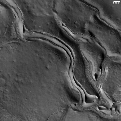
Frozen lava in Mars’ volcano country

The frozen lava of the Athabasca flood plain
Click for full image.

Cool image time! The photo to the right, cropped and reduced to post here, was taken on January 28, 2022 by the high resolution camera on Mars Reconnaissance Orbiter (MRO). It shows what appears to be at first glance a relatively featureless plain with a lighter material covered by a patchwork of darker material.

Note however the lack of craters. Except for several faint depressions near the image’s center, there are none. And those depressions look like the expression of craters that have been covered by material. Is the two-toned surface here an expression of past lava flows? Or are we seeing an ice-sheeted plain, with the patches representing higher terrain above that plain?

The overview map below answers the question somewhat clearly.
» Read more

Astronomers confirm comet with largest nucleus ever found

Using the Hubble Space Telescope astronomers determined that the nucleus of Comet Bernardinelli-Bernstein (C/2014 UN271) is about 80 miles wide, making it the largest comet on record.

The estimated diameter is approximately 80 miles across, making it larger than the state of Rhode Island. The nucleus is about 50 times larger than found at the heart of most known comets. Its mass is estimated to be a staggering 500 trillion tons, a hundred thousand times greater than the mass of a typical comet found much closer to the Sun.

The behemoth comet, C/2014 UN271 (Bernardinelli-Bernstein) is barreling this way at 22,000 miles per hour from the edge of the solar system. But not to worry. It will never get closer than 1 billion miles away from the Sun, which is slightly farther than the distance of the planet Saturn. And that won’t be until the year 2031.

The previous record holder is comet C/2002 VQ94, with a nucleus estimated to be 60 miles across. It was discovered in 2002 by the Lincoln Near-Earth Asteroid Research (LINEAR) project.

This measurement does have a great deal of uncertainty, as Hubble cannot yet resolve the nucleus, and thus its diameter was determined by computer models based on the size of the comet’s coma, or surrounding atmosphere.

The comet itself has an orbit 3 million years long, which means it has zipped into the inner solar system many many times. The reason its nucleus remains so large is because its orbit never gets that close to the Sun, so its material does not get burned off so much with each perihelion. That it exists suggests there could be many such large comets which never dip close to the Sun.

MAVEN and Al-Amal scientists sign agreement to collaborate

Scientists running the Mars orbiters MAVEN (from NASA) and Al-Amal (from the United Arab Emirates [UAE]) have signed an agreement to share data and — more importantly — coordinate their observations of the Martian atmosphere.

A new partnership that encourages the sharing of data between NASA’s MAVEN (Mars Atmosphere and Volatile Evolution) project and the Emirates Mars Mission’s (EMM) Hope Probe (Al-Amal in Arabic) will enhance scientific returns from both spacecraft, which are currently orbiting Mars and collecting data on the Red Planet’s atmosphere. The arrangement is expected to add value to both MAVEN and EMM, as well as the scientific communities involved in analyzing the data the missions collect.

MAVEN went into orbit around Mars in 2014. Its mission is to investigate the upper atmosphere and ionosphere of Mars, offering an insight into how the planet’s climate has changed over time. “MAVEN and EMM are each exploring different aspects of the Martian atmosphere and upper-atmosphere system,” said Shannon Curry, MAVEN principal investigator from the University of California, Berkeley. “Combined, we will have a much better understanding of the coupling between the two, and the influence of the lower atmosphere on the escape to space of gas from the upper atmosphere.”

The EMM Hope Probe, which went into Mars orbit in 2021, is studying the relationship between the upper layer and lower regions of the Martian atmosphere, giving insight into the planet’s atmosphere at different times of the day and seasons.

What this agreement means is that the two science teams can more quickly match up the data from both orbiters, and figure out the relationships between both.

Interstellar meteor impacted Earth in 2014

According to classified military data just released, it appears that an asteroid from interstellar space impacted the Earth in 2014, with some of its pieces possibly hitting the ocean in the south Pacific.

The meteor ignited in a fireball in the skies near Papua New Guinea, the memo states, and scientists believe it possibly sprinkled interstellar debris into the South Pacific Ocean. The confirmation backs up the breakthrough discovery of the first interstellar meteor—and, retroactively, the first known interstellar object of any kind to reach our solar system—which was initially flagged by a pair of Harvard University researchers in a study posted on the preprint server arXiv in 2019.

Amir Siraj, a student pursuing astrophysics at Harvard who led the research, said the study has been awaiting peer review and publication for years, but has been hamstrung by the odd circumstances that arose from the sheer novelty of the find and roadblocks put up by the involvement of information classified by the U.S. government.

The speed and angle in which the object hit the atmosphere are why the scientists believe it comes from outside the solar system.

Siraj is actually hoping to mount a mission to recover parts of this asteroid, something that is extremely unlikely. First, the meteor itself was small, so it likely all burned up in re-entry. Second, even if pieces survived, finding them on the bottom of the Pacific is likely impossible.

Curiosity retreating from Greenheugh Pediment

Overview map
Click for interactive map.

Because of the incredible roughness of the ground on the Greenheugh Pediment, the science team for the rover Curiosity has decided to make a major change in their route. Rather than continue their traverse across this terrain, as planned for years, they have decided to back off in order to protect Curiosity’s dinged wheels, and find a more friendly route up Mount Sharp.

“It was obvious from Curiosity’s photos that this would not be good for our wheels,” said Curiosity Project Manager Megan Lin of NASA’s Jet Propulsion Laboratory in Southern California, which leads the mission. “It would be slow going, and we wouldn’t have been able to implement rover-driving best practices.”

The gator-back rocks aren’t impassable – they just wouldn’t have been worth crossing, considering how difficult the path would be and how much they would age the rover’s wheels.

So the mission is mapping out a new course for the rover as it continues to explore Mount Sharp, a 3.4-mile-tall (5.5-kilometer-tall) mountain that Curiosity has been ascending since 2014. As it climbs, Curiosity is able to study different sedimentary layers that were shaped by water billions of years ago. These layers help scientists understand whether microscopic life could have survived in the ancient Martian environment.

The plan is to retrace the rover’s path back through Gordon Notch and then head uphill though another gap that will take it directly onto the next sedimentary layer, dubbed the sulfate unit. On the overview map above, the red dotted line shows the long-planned route. The yellow lines indicate the area seen in the panorama I posted on April 6th, when Curiosity was at its farthest into the pediment. The blue dot marks Curiosity’s position two days ago. You can see that it has retreated backwards.

This change means the scientists will likely not get a close look at Gediz Vallis Ridge. However, it also means the rover will likely reach Gediz Vallis much sooner that previously planned.

Neptune’s cooling when it should be warming

Neptune since 2006

The uncertainty of science: Observations of Neptune during the past seventeen years using the Very Large Telescope have shown the planet mostly cooling during this time period, even though Neptune was moving into its summer season.

Astronomers looked at nearly 100 thermal-infrared images of Neptune, captured over a 17-year period, to piece together overall trends in the planet’s temperature in greater detail than ever before. These data showed that, despite the onset of southern summer, most of the planet had gradually cooled over the last two decades. The globally averaged temperature of Neptune dropped by 8 °C between 2003 and 2018.

The astronomers were then surprised to discover a dramatic warming of Neptune’s south pole during the last two years of their observations, when temperatures rapidly rose 11 °C between 2018 and 2020. Although Neptune’s warm polar vortex has been known for many years, such rapid polar warming has never been previously observed on the planet. “Our data cover less than half of a Neptune season, so no one was expecting to see large and rapid changes,” says co-author Glenn Orton, senior research scientist at Caltech’s Jet Propulsion Laboratory (JPL) in the US.

The sequence of photos above show that change over time. Lower latitudes generally get darker, or cooler, while the south pole suddenly brightens, getting hotter, in 2020.

The scientists have no idea why this has happened, though they have theories, ranging from simple random weather patterns to the influence of the Sun’s sunspot cycle.

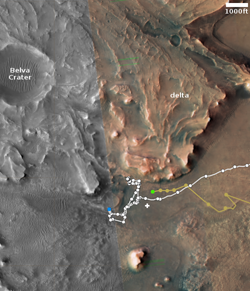
Perseverance arrives at Three Forks at the base of Jezero Crater’s delta

Panorama of delta in Jezero Crater
Original images found here, here, here, and here. Click for full resolution.

Overview map
Click for interactive map.

Cool image time! The panorama above was created from four navigation camera images taken by the Mars rover Perseverance on April 10th. Because the lens on Perseverance’s navigation cameras produce slightly curved images which are taken in pairs, the panorama is made of two parts, each a pair perfectly matched images looking from a different angle. I have overlapped the pairs but as you can see, the match at the center is imperfect. While this does not produce a single smooth image, the two paired panoramas show the foot of the entire delta that had flowed into Jezero crater in the past and is the prime geological target of the rover. What is it made of? What caused it to flow into the crater? When did it do it? How was Mars different when it did so? Was the crater wet? Was the delta mud when it flowed, or was it sediment under water, pushed out by that flowing water?

The location map to the right is taken from the “Where is Perseverance?” webpage but annotated to show the planned routes of both Perseverance and Ingenuity, as shown by the tan dashed lines. The red dot marks Perseverance present location, the green dot Ingenuty’s. The yellow lines the approximate area covered by the panorama.

What next? Expect Perseverance to move as close to the base of the delta’s cliff as possible and spend at least several months studying it. Ingenuity meanwhile will be flown to the west to scout the various hollows that are potential routes for Perseverance to climb up onto the delta.

Splonk went the crater!

Splonk went the crater!
Click for full image.

Cool image time! The photo to the right, cropped and reduced to post here, was taken on February 18, 2022 by the high resolution camera on Mars Reconnaissance Orbiter (MRO). It shows what the scientists label as a “degraded crater in Utopia Planitia.”

There is a lot of intriguing geology in this one image. First of course is the crater itself. We have to ask, is it from an impact or from some volcanic process? The location, at 44 degrees north latitude, argues that some form of ice or mud process was involved. Maybe we are looking at a frozen eruption from an underground ice layer. If this was instead caused by an impact, the crater’s ringlike structure could have been created by the ripples of melted ice and mud emanating away but then quickly refreezing.

Surrounding the crater are many small fissures, the largest ones all oriented in a north-south direction. If there is an ice layer near the surface, these cracks might be caused by that ice sublimating away. Why the largest cracks orient in the same direction however is a mystery.

The color variations suggest [pdf] dust (red-orange) as well as a variety of minerals (green). Since no blue appears visible in this version of the photo, if this crater was shaped by melting or erupting ice, that ice is well covered by that layer of dust and debris.

The location map below as always provides context.
» Read more

New data contradicts accepted standard model of particle physics

The uncertainty of science: After years of analysis, physicists have refined their measurement of the mass of one important subatomic particle, and discovered that its weight violates the accepted standard model of particle physics, threatening to overthrow it entirely.

W bosons are elementary particles that carry the weak force, mediating nuclear processes like those at work in the Sun. According to the Standard Model, their mass is linked to the masses of the Higgs boson and a subatomic particle called the top quark. In a new study, almost 400 scientists on the Collider Detector at Fermilab (CDF) collaboration spent a decade examining 4.2 million W boson candidates collected from 26 years of data at the Tevatron collider. From this treasure trove, the team was able to calculate the mass of the W boson to within 0.01 percent, making it twice as precise as the previous best measurement.

By their calculations, the W boson has a mass of 80,433.5 Mega-electronvolts (MeV), with an uncertainty of just 9.4 MeV either side. That’s within the range of some previous measurements, but well outside that predicted by the Standard Model, which puts it at 80,357 MeV, give or take 6 MeV. That means the new value is off by a whopping seven standard deviations.

Further cementing the anomaly, the W boson mass was also recently measured using data from the Large Hadron Collider, in a paper published in January. That team came to a value of 80,354 MeV (+/- 32 MeV), which is comfortably close to that given by the Standard Model.

Personally, I always take this level of physics with a great deal of skepticism. The data involves a lot of assumptions and uncertainties. That other researchers came up with a different number illustrates this.

Nonetheless, these results could suggest that the standard model, the consensus theory for decades, is either incomplete, or wrong. The former would be more likely, but no possibility should be dismissed. And even if wrong, much of that model still works so well any new model must include large parts of it.

Connecting the dots of the COVID lie

What our leaders want us to be

There were many reasons the world panicked in 2020 when COVID appeared and spread from China. Some of that panic was motivated by natural fear of an unknown disease. Some of it was motivated by a desire for power, harnessing that fear to nullify the Bill of Rights and the legal restraints on dictatorship. Some of it was inspired by a simple blind hatred of Donald Trump, and saw an opportunity to use the virus as a tool for getting him out of power. And some of the actions of our leaders was motivated by pure and simple greed, willing to let millions die so that they could personally get rich, or richer.

To connect the dots to understand the worst players in this terrible story, we need to look at more than one story or report, each telling us something that the fear-mongers have tried to hide from us so that their dishonest and sometimes quite evil motives might not be recognized.

To begin, there are these two stories, showing that we now have solid evidence that the military committed fraud in order to hide data that showed the COVID shots were causing a terrible number of health injuries and deaths to soldiers being ordered to take them.

From the first story, describing a lawsuit that claims the Defense Department committed fraud:
» Read more

Curiosity’s upcoming rough terrain

Curiosity's view looking west on April 5, 2022 (Sol 3435)Click for high resolution. For original images go here, here, here, and here.

Overview map
Click for interactive map.

Cool image time! The panorama above, created by me from four photos taken by Curiosity’s right navigation camera on April 5, 2022, reveal much about the alien world of Mars that the rover is exploring. The red dotted line indicates approximately the rover’s upcoming route.

First there is the rough surface of the Greenheugh Pediment, the sloping plateau that Curiosity is presently traversing. Called “gater-back terrain” by the science team, this broken surface apparently is sandstone that was originally a dune field that in the past was periodically washed by water runoff and later hardened into this structurally weak rock.

Second, I have orientated the images so that the rim of Gale Crater, approximately 25 miles away, is horizontal. By doing so, we can see the upward slope of the Greenheugh Pediment. Curiosity is on a tilted surface, and while it will be traversing along a contour line as it heads west towards Gediz Vallis Ridge about 1,000 feet away, when it turns left and heads uphill, the climb will be steady and steep, as it has now been for the past year since the rover entered the mountains at the foot of Mount Sharp.

Taken together, these details indicate why Curiosity has moved very slowly in recent weeks, as shown by the white dots in the overview map to the right. The blue dot marks Curiosity’s present location, with the yellow lines indicate the approximate view in the panorama above.

Traversing the pediment carries real risk to the rover. Though its somewhat dinged wheels have held up well during this last year of traveling in these rough mountains, at any point the severe roughness here could damage one or more wheels significantly, even putting one or more out of commission. The rover team is traveling carefully to avoid this, but these factors illustrate a possible end for the rover, though hopefully still years away.

Inspector General: NASA’s lunar rover VIPER mission on schedule, with some cost increases

VIPER's planned route on the Moon

According to a report [pdf] issued today by NASA’s inspector general, the agency’s VIPER lunar rover mission is generally on schedule for its ’23 launch, though it has experienced some cost increases and still carries some scheduling risks, mostly related to the development of Astrobotic’s commercial Griffin lunar lander, and its precursor Peregrine mission that ULA hopes to launch on its first Vulcan rocket test.

Although Astrobotic personnel explained that Griffin’s development schedule is largely independent of its Peregrine mission, the Peregrine Lander—planned to launch in 2022—has multiple systems and subsystems that will also be used on Griffin. Therefore, any technical problems with these systems may adversely affect development of the Griffin Lander because Astrobotic would only have about a year, depending on the Peregrine launch date and start of lunar operations, to resolve the issues prior to NASA delivering VIPER for integration and launch. Furthermore, any failures during the Peregrine mission may lead to Griffin delays as NASA and Astrobotic investigate the failures and develop corrective actions.

In addition, VIPER long-lead acquisitions—such as the rover solar power array and avionics unit—have been affected by aerospace industry supply chain delays caused by COVID-19 as have delivery of computer boards and motor parts. Both of these issues have impacted design verification testing needed for the mission’s Critical Design Review, while COVID-19 also delayed some component development schedules.

Peregrine’s launch has been delayed by a year because Vulcan has been delayed because of Blue Origin’s problems with the BE-4 rocket engine. Though ULA hopes the Vulcan/Peregrine launch can occur late this year, that date remains very much in doubt. Further launch delays would thus threaten the launch of Griffin and VIPER.

As for the cost increases, the IG found that NASA had been forced to increase the budget for VIPER by 18.1%, a relatively minor increase compared to many of NASA’s other big projects. The IG noted however that further cost overruns are very possible, especially if the Peregrine mission experiences problems.

The photo above shows the rover’s presently planned route in the relatively flat area about 85 miles from the Moon’s south pole and near the western edge of Nobile Crater (pronounced No-BEEL-e).

Scientists decide propaganda and commercials are better than good research results

The on-going dark age: In a new study scientists have discovered that — instead of depending on hard research that is repeatedly confirmed by others — if they simply use a trusted spokesman in commercials promoting their work they can get people to accept their conclusions, at face value.

This momentous discovery occurred when some researchers decided to find out if putting Trump in a 30-second commercial asking people to get the COVID jab would encourage them to do so. This is what the test learned:

A creative effort to use former President Donald Trump to persuade people to get a COVID-19 vaccine shot appears to have paid off. An online advertisement created by a team of political scientists and economists that featured Trump recommending COVID-19 shots led to increased uptake of the vaccines in U.S. counties that had low vaccination rates, concludes a new analysis.

“We were so thrilled,” says Marc Hetherington, a political scientist at the University of North Carolina, Chapel Hill, who helped create the ad and co-authored the study. “How often do political scientists and economists do anything that helps the world? The answer is, like, 0% of the time.”

…The results highlight that “health communication needs to come from trusted messengers and to meet people where they are,” says behavioral scientist Katherine Milkman of the University of Pennsylvania, who was not involved in the study. [emphasis mine]

Hetherington’s highlighted quote was intended to imply that this research proved that political scientists and economists sometimes do do something that helps the world. I think it only proves that they never do.

Using advertising to sell a scientific conclusion is without doubt the most corrupt and idiotic method for selling a scientist’s work. It only proves the work itself, in this case the COVID shots, have questionable aspects that need propaganda to convince people of their value.

Other quotes from different scientists at the link also illustrate how divorced from actual research and data these scientists are. To their minds, the doubt that many people have of the COVID shots can only be attributed to an “antivaccine ecosystem” touting its own political agenda. The extensive research and data that suggests the shots carry risks while appearing possibly useless is either ignored by these scientists, or they are willfully ignorant of it.

1 60 61 62 63 64 277