NASA awards Intuitive Machines another contract to deliver science instruments to Moon

Capitalism in space: NASA yesterday awarded Intuitive Machines its third contract to use its Nova-C lander to deliver four science instruments in 2024 to an unusual geological feature on the Moon.

The investigations aboard Intuitive Machines’ Nova-C lander are destined for Reiner Gamma, one of the most distinctive and enigmatic natural features on the Moon. Known as a lunar swirl, Reiner Gamma is on the western edge of the Moon, as seen from Earth, and is one of the most visible lunar swirls. Scientists continue to learn what lunar swirls are, how they form, and their relationship to the Moon’s magnetic field.

…Intuitive Machines will receive $77.5 million for the contract and is responsible for end-to-end delivery services, including payload integration, delivery from Earth to the surface of the Moon, and payload operations. This is Intuitive Machines’ third task order award, the first of which is a delivery to Oceanus Procellarum on the Moon during the first quarter of 2022. This award is the seventh surface delivery task award issued to a CLPS partner.

Below is the present schedule for these commercial unmanned lunar landers:

  • 2022: Astrobotic to deliver 11 instruments to the crater Lacus Mortis.
  • 2022: Intuitive Machines to deliver 6 payloads to Oceanus Procellarum.
  • 2022: Intuitive Machines to deliver a drill and two instruments to the lunar south pole.
  • 2023: Firefly to deliver 10 instruments to Mare Crisium.
  • 2023: Masten to deliver nine instruments to the lunar south pole region.
  • 2023: Astrobotic to deliver VIPER rover to lunar south pole region.
  • 2024: Intuitive Machines to deliver 4 payloads to Reiner Gamma.

No one should be surprised if some of these landers fail. The goal of this program is to jumpstart a commercial industry of private lunar landers, which is why NASA is awarding so many contracts. Some will fail. Some will succeed. In the end both NASA and the general public will have several competing options for landing payloads on the Moon.

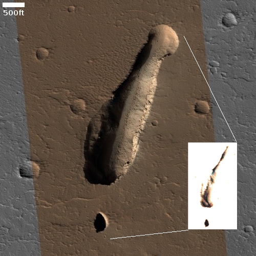
Volcanic vent on Mars

Overview of Arsia Mons pits

To understand today’s cool image we really should start from a distance and zoom in. The overview map to the right focuses in on the two southernmost giant volcanoes in the string of three that sit to the east of Mars’ biggest volcano, Olympus Mons, and to the west of the planet’s biggest canyon, Valles Marineris.

The black dots mark the locations of the many high resolution photos taken by Mars Reconnaissance Orbiter that I have featured previously on Behind the Black. Many are isolated openings with no related geological features. Others appear to be skylights into a more extensive lava tube, hinted at by either a continuing surface depression or a series of similar skylights.

The white dot marks the location of today’s cool image, about 350 miles south of Arsia Mons’ caldera.
» Read more

UAE Al-Amal Mars orbiter finds surprising variations in Mars atmosphere

Oxygen variations in Martian atmosphere
Click for full graphic.

The United Arab Emirates Al-Amal (“hope” in English) Mars orbiter has discovered unexpected variations of oxygen and carbon monoxide in the Martian atmosphere.

The EMM team had expected to observe a relatively uniform emission from oxygen at 130.4 nm across the planet and yet here we are, faced with unpredicted variations of 50% or more in the brightness.

The image to the right, cropped and reduced to post here, shows the variations in oxygen on Mars’s dayside. Though the map does not indicate the geography below, the concentration of oxygen in the northern latitudes appears to correspond to the planet’s northern lowland plains. In fact, the variations should not have been a surprise, since the surface of Mars has such a stark dichotomy between its northern and southern hemispheres.

Craters in the soft Martian northern lowland plains

Craters in the soft Martian northern lowland plains
Click for full image.

Cool image time! The photo to the right, cropped and reduced to post here, was a featured image today from the high resolution camera on Mars Reconnaissance Orbiter (MRO).

The caption, written by Carol Weitz of the Planetary Science Institute in Arizona, focused on the wind patterns created within these craters.

These impact craters in the northern middle latitudes have interesting interiors: all of them have wind-blown (aeolian) ripples.

Outside of the craters and along the crater floors, the ripples are all oriented in the same direction. However, along the walls of some of the larger craters, the ripples are situated radially away from the center, indicating the winds moving inside the larger craters can be influenced by the topography of the crater wall.

Additionally, many of the larger craters have layered mesas along their floors that are likely sedimentary deposits laid down after the craters formed but prior to the development of the aeolian ripples.

I am further intrigued by the rimless nature of these craters, as well as the lack of significant rocky debris at their edges. They all look like the bolides that created them impacted into a relatively soft surface that, rather than break up into rocks and boulders, melted, flowed, and then quickly refroze into these depressions.

The location, as always, provides us a possible explanation.
» Read more

Zhurong’s continuing travels on Mars

Zhurong overview map
Click for original map.

This past week the Chinese press released a new but limited update on the status of both its Mars orbiter Tianwen-1 and its Mars rover Zhurong.

The map to the right uses as its background a high resolution picture from Mars Reconnaissance Orbiter. I have superimposed Zhurong’s route in green. You can get an idea of how far the rover has traveled since resuming communications with Earth in late October by comparing this map with the one I posted then. After stopping at a small sand dune (the crescent-shaped white features), it curved around to head to the southeast towards a rough area and a trough that is thought to be filled with sediment.

Meanwhile, the orbiter has shifted its orbit, changing from one dedicated mainly as providing a communications relay between Zhurong and Earth to one that now allows it to begin a two-year photographic survey of Mars.

To supplement the resulting gaps in communications for Zhurong, China and the European Space Agency (ESA) have made their first test using ESA’s Mars Express satellite as a relay satellite. Both hope to know soon whether it worked.

In either case, Zhurong’s travels will likely be slowed somewhat due to the reduction in communications access.

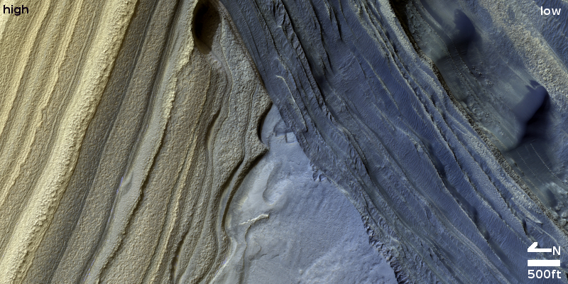
Snow on Martian dunes

Snowy dunes near the Martian north pole
Click for full image.

Close-up of snowy dunes
Click for full image.

Cool image time! The first photo to the right, rotated, cropped, and reduced to post here, was taken on September 19, 2021 by the high resolution camera on Mars Reconnaissance Orbiter (MRO), and shows what appears to be snow nestled in the hollows of many dunes.

The second photo, cropped to post here, shows in high resolution the area in the white box.

Is that snow water, or dry ice? The location is very far north, 76 degrees latitude, so it could be either. Since the photo was requested by Candice Hansen of the Planetary Science Institute in Arizona, I emailed her to ask. Her answer:

Early in the spring all the bright stuff is dry ice. As it gets later in the spring it is probably still mostly dry ice but with HiRISE images alone we cannot really distinguish the composition of the ice. In-between the dunes it is almost certainly bare ground late in the spring, but since the dunes are dark the surface just looks bright in contrast

This picture was taken in summer, which suggests the snow is probably water, not dry ice. Yet, all the snow is found in the north-facing hollows, places that will remain mostly in shadow at this high latitude, 76 degrees north. Thus, it is possible that the snow is the last remaining traces of the thin dry ice mantle that covers the Martian poles down to about 60 degrees latitude during the winter, and sublimates away in summer.

Hansen had requested a whole bunch of similar images of such snowy dunes. As she explained,
» Read more

Scientists: Asteroid in an orbit entwined with the Earth might be Moon rock

Data obtained by scientists using ground-based telescopes now suggests that the small asteroid Kamo`oalewa, which has an orbit that makes it a quasi-Moon of the Earth, might have originally come from the Moon.

From their paper’s abstract:

We find that (469219) Kamoʻoalewa rotates with a period of 28.3 (+1.8/−1.3) minutes and displays a reddened reflectance spectrum from 0.4–2.2 microns. This spectrum is indicative of a silicate-based composition, but with reddening beyond what is typically seen amongst asteroids in the inner solar system. We compare the spectrum to those of several material analogs and conclude that the best match is with lunar-like silicates. This interpretation implies extensive space weathering and raises the prospect that Kamo’oalewa could comprise lunar material.

Kam’oalewa — which is only about 150 feet across — is one of five such quasi-Earth-moons. All orbit the Sun in orbits that are similar to the Earth’s and are such that the asteroids periodically loop around our planet each year.

This data will be useful to the Chinese, who are planning a mission to Kamo-oalewa in ’24 to grab samples.

The stormy atmosphere of Jupiter

Jupiter's South South Temperate Belt
Click for full image.

Cool image time! The photo to the right, cropped to post here, was created by citizen scientist Thomas Thomopoulo from a Juno image taken during its 16th close pass of Jupiter in 2018. To bring out the different colors of the clouds he enhanced the resolution and color contrast.

We have no scale, but I would guess the distances seen exceed several thousand miles. The area covered is what is called Jupiter’s South South Temperate Belt, the visible belt at about 40 degrees south latitude that circles the South Polar Region (which is the darker purple swirls in the bottom left). This belt is difficult to observe from Earth because of its high latitude, with the curve of Jupiter’s limb beginning to bend away from view.

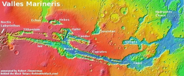
A volcanic extrusion on the floor of Valles Marineris?

A volcanic extrusion on the floor of Valles Marineris?
Click for full image.

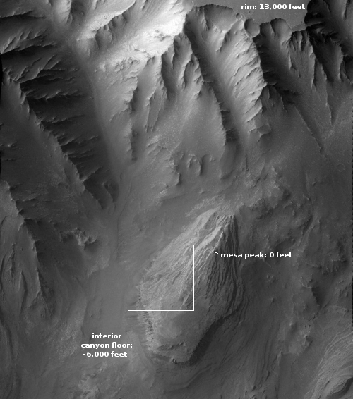
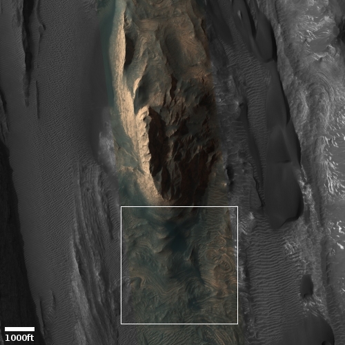
Cool image time! The photo to the right, rotated, cropped, and reduced to post here, was taken on August 31, 2021 by the high resolution camera on Mars Reconnaissance Orbiter (MRO). It shows what the science team labels a “possible contact between two units.”

I think that contact is the point where that eroded mountain touches the surrounding smooth canyon floor. The mountain itself looks to me to be a very eroded extrusion of lava that was placed there from below a very very long time ago, covered later by material, and now exposed for a long enough period that its surface appears to have been carved by wind and even possibly flowing water or ice.

Because it is lava it is more resistant to erosion, which is why it sits higher than the smooth terrain around it. Even though both experienced the same processes of wear over time, the mountain’s surface was only carved away partly, while the material that had been in the floor was washed away entirely.

This is all a guess. However, a look below at the overview map, showing this mountain’s location on Mars, as well as MRO’s wider view from its context camera, I think strengthens my hypothesis.
» Read more

Lucy’s solar panel problem could be due to strap

According to the engineering team for the Lucy asteroid mission, they now think the incomplete deployment of one of the probe’s solar panels was caused by a strap.

The joint Anomaly Response Team has been studying the array using an engineering model. Initial tests indicate that the lanyard that pulls out the solar array may not have completed the process successfully; however, it is still uncertain what caused this condition. The team is conducting more tests to determine if this is indeed the case, and what the root cause might be.

An attempt to characterize the array deployment by attempting to move it would occur no earlier than Nov. 16.

Meanwhile, they have been turning on Lucy’s instruments one by one, with everything functioning as planned, except for that one solar panel. The panel however is a serious concern, as the spacecraft is heading out to the orbit of Jupiter, where it will need every inch of solar panel surface area to get enough power to operate. At the moment it appears the panel is deployed somewhere between 75% to 95%.

Hubble camera back in operation

Good news! As engineers work to fix the problem that caused the Hubble Space Telescope to shut down on October 25th, they have now successfully returned Hubble’s most important camera back to doing science.

The Hubble team successfully recovered the Advanced Camera for Surveys instrument Nov. 7. The instrument has started taking science observations once again. Hubble’s other instruments remain in safe mode while NASA continues investigating the lost synchronization messages first detected Oct. 23. The camera was selected as the first instrument to recover as it faces the fewest complications should a lost message occur.

This success strongly suggests they have pinpointed the software issue that caused the shutdown, and can now step-by-step reactivate all the other instruments in the coming week.

Frozen lake bed in the Martian high latitudes?

Frozen lakebed in the Martian high latitudes?
Click for full image.

Today’s cool image comes from today’s Mars Reconnaissance Orbiter’s (MRO) high resolution picture of the day, rotated and cropped to post here. The original was taken back on March 28, 2017.

What formed those strange circular ridges and the many small cracks and hollows? The caption provided is somewhat vague and I think confusing:

This formation looks like a crater from a meteor impact rather than an ancient caldera of a volcano. Connected to the crater is a carved-out area that resembles a lake bed. At high resolution, we might be able to determine the likelihood of a water lake bed or lava bed. This observation will give insight into some of the interesting geology of this area.

The crater this caption is referring to is not visible in the image provided. It can be seen to the west of this location, in the MRO context camera picture below.
» Read more

Curiosity: Approaching the saddle

The saddle ahead
Click for full image.

Cool image time! The photo to the right, reduced to post here, was taken on November 5, 2021 by Curiosity’s high resolution camera, and looks forward at its planned route up onto the saddle ahead, where the rover will turn right and climb up into Maria Gordon Notch. (See this October post for a map outlining the rover’s future travels.) I think that cliff face is between 40 to 60 feet high, though this is a very wild guess.

As noted by Abigail Fraeman of JPL on the Curiosity blog on November 3, 2021,

The terrain is beginning to steepen as Curiosity gets close to the end of this region, so even though we’re only a few drives away from our last drill site … we’ve already climbed 25 m higher!

The route ahead looks equally steep, though the ground actually appears less rough, with fewer large jagged boulders that Curiosity must avoid to protect its wheels.

It will likely be at least one to three weeks however before Curiosity gets to that saddle. The science team has begun a drilling campaign at the present location, and this will take time, depending on how many holes they decide to drill.

Ingenuity completes 15th flight

Ingenuity landing on November 6th
Click for full image.

No details have been released, but based on the latest raw images downloaded from the Mars rover Perseverance today, the helicopter Ingenuity successfully completed its 15th flight in Jezero Crater yesterday.

The image to the right is the last of five released this morning, showing the helicopter’s shadow on the ground, just before Ingenuity touched down. Note how the shadow of Ingenuity’s four legs appear oriented level relative to the ground. While the first of the five images shows the shadow tilted, as if the helicopter is making a last turn, the last four photos all show the legs oriented properly.

We will have to wait now for official confirmation.

Ingenuity next flight will begin route retracing its path

Overview map

The Ingenuity engineering team has revealed that the helicopter’s 15th flight on Mars will have it begin retracing its steps, following approximately the same flight route as it heads back towards Perseverance’s landing site in Jezero Crater.

Flight #15 is the start of our journey back to Wright Brothers Field [the helicopter’s initial flight test area just north of the landing site]. Taking place no earlier than Saturday, Nov. 6 at 9:22 a.m. PT, or 12:03 LMST (local Mars time), the 254th sol (Martian day) of the Perseverance mission, Flight #15 will return Ingenuity back to the Raised Ridges region, imaged in Flight #10. In this flight the helicopter will traverse 1,332 feet (406 meters) during 130 seconds of flight, travelling at 11.1 mph (5 mps) groundspeed. We’ll capture color return-to-earth (RTE) high resolution (13MP) images, one post-takeoff pointed to the SW, and nine pointed toward the NW along the flight-path. Nominal altitude for the flight is expected to be 39.3 feet (12 meters) above ground level.

This will be the second flight of Ingenuity during Mars’ summer low air-density, requiring that the rotor blades are spun at 2,700 RPM to compensate. This flight will generate critical high-RPM motor performance, which the team will use to design and tailor upcoming low-density flights in the months ahead.

Perseverance is presently sitting in an area they have dubbed Seitah, a region the rover skirted around to get to this point. I had hoped both the helicopter and rover would return to the north cutting across Seitah and thus scout out new terrain. Instead, it appears that both the rover and helicopter will return as initially planned, traveling over the same ground both took to get where they are today.

In other words, the teams have decided to take the safest route, though it will provide them much less new science data. While this might seem prudent, it really appears overly cautious, based on the capabilities of Perseverance and the roughness of the terrain in Seitah. Curiosity is presently traveling across far more difficult terrain in the mountains at the foot of Mt Sharp, and it is doing so with wheels that are damaged and not as well designed as Perseverance’s. Not roving in uncharted terrain seems a waste of Perseverance’s capabilities.

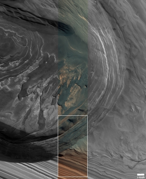
The strange surface of Mars’ north pole icecap

Mars' north pole icecap
Click for full image.

Cool image time! The photo to the right, rotated, cropped, and annotated to post here, was taken on September 17, 2021 by the high resolution camera on Mars Reconnaissance Orbiter (MRO). It shows us a very small section of Mars’ north pole icecap.

What are we looking at? The picture was taken in summer, so by this point the thin mantle of dry ice that falls as snow in the winter and covers the north pole down to about 60 degrees latitude has sublimated away. This surface thus is water ice interspersed with Martian dust.

Yet, unlike the Antarctic icecap on Earth, the ice surface is not smooth and flat. Instead, this Martian ice has a surface that is a complex arrangement of hollows and ridges, all about the same size. Why?

And what are the two larger white spots? What caused them and why are they the only differently-sized objects in the picture?

The full resolution close-up, found at the image website, provides some answers to these questions.
» Read more

Skimming over the cloud tops of Jupiter

Skimming over the cloud tops of Jupiter
Click for full image.

Cool image time! The computer visualization above is based on a orbital image of Jupiter taken by Juno, but processed by citizen scientist Ryan Cornell to give, as he puts it, a view “as if we had a low orbit above the clouds.”

I estimate the scale of these clouds is quite large, with the Earth easily fitting inside the orange band on the right. The sharp horizon edge is a not accurate, however, as the clouds would have a decidedly fuzzy boundary, possibly many thousand miles in extent.

Nonetheless, it is a fun image that begins to give us a sense of Jupiter’s upper atmosphere.

Landing site chosen for Intuitive Machines Nova-C lunar lander

NASA scientists have now chosen the landing site for the privately built Nova-C lunar lander, built and designed by Intuitive Machines, that late next year will carry three science instruments to a ridge close to Shackleton Crater near the Moon’s south pole.

NASA data from spacecraft orbiting the Moon indicate this location, referred to as the “Shackleton connecting ridge,” could have ice below the surface. The area receives sufficient sunlight to power a lander for roughly a 10-day mission, while also providing a clear line of sight to Earth for constant communications. It also is close to a small crater, which is ideal for a robotic excursion.

These conditions offer the best chance of success for the three technology demonstrations aboard. This includes the NASA-funded Polar Resources Ice-Mining Experiment-1 (PRIME-1) – which consists of a drill paired with a mass spectrometer – a 4G/LTE communications network developed by Nokia of America Corporation, and Micro-Nova, a deployable hopper robot developed by Intuitive Machines.

One of the goals of the mission is to drill down three feet to see if ice can be detected. Another is to simply test this engineering to better refine it for the many other unmanned lunar missions that will follow in the next few years.

Astronomers detect water in the very very early universe

The uncertainty of science: Using the ALMA telescope in Chile, astronomers have detected the molecules of water and carbon monoxide in a galaxy thought to have formed only 780 million years after the Big Bang.

SPT0311-58 is actually made up of two galaxies and was first seen by ALMA scientists in 2017 at its location, or time, in the Epoch of Reionization. This epoch occurred at a time when the Universe was just 780 million years old—roughly 5-percent of its current age—and the first stars and galaxies were being born. Scientists believe that the two galaxies may be merging, and that their rapid star formation is not only using up their gas, or star-forming fuel but that it may eventually evolve the pair into massive elliptical galaxies like those seen in the Local Universe.

“Using high-resolution ALMA observations of molecular gas in the pair of galaxies known collectively as SPT0311-58 we detected both water and carbon monoxide molecules in the larger of the two galaxies. Oxygen and carbon, in particular, are first-generation elements, and in the molecular forms of carbon monoxide and water, they are critical to life as we know it,” said Sreevani Jarugula, an astronomer at the University of Illinois and the principal investigator on the new research. “This galaxy is the most massive galaxy currently known at high redshift, or the time when the Universe was still very young. It has more gas and dust compared to other galaxies in the early Universe, which gives us plenty of potential opportunities to observe abundant molecules and to better understand how these life-creating elements impacted the development of the early Universe.”

Need I say that there are many uncertainties with this result, including the assumption that the universe is only 780 million years old at location of this galaxy. That age is extrapolated from the galaxy’s red shift, a link that depends on some uncertain assumptions. Moreover, the discovery of these molecules so soon after the theorized Big Bang is unexpected. Cosmologists had assumed that at this early age the universe wasn’t old enough yet to form galaxies with such complex molecules.

Hubble still in safe mode

NASA released a new but relatively terse update on November 1st describing the status of the Hubble Space Telescope, which has been in safe mode since October 25th.

Hubble’s science instruments issued error codes at 1:46 a.m. EDT Oct. 23, indicating the loss of a specific synchronization message. This message provides timing information the instruments use to correctly respond to data requests and commands. The mission team reset the instruments, resuming science operations the following morning.

At 2:38 a.m. EDT, Oct. 25, the science instruments again issued error codes indicating multiple losses of synchronization messages. As a result, the science instruments autonomously entered safe mode states as programmed.

Mission team members are evaluating spacecraft data and system diagrams to better understand the synchronization issue and how to address it. They also are developing and testing procedures to collect additional data from the spacecraft. These activities are expected to take at least one week.

In other words, the engineers presently do not understand the problem, and are working at pinpointing its cause.

This is not a “glitch”. If used properly that word really refers to something that is akin to a short burp in operations. Hubble has been shut down now for ten days, and will remain so for at least one more week. This is a serious problem that remains unsolved.

Two skylights into connected Martian lava tube?

Two skylights into a connected Martian lava tube?
Click for full image.

Cool image time! The photo to the right, cropped and annotated to post here, was taken on September 1, 2021 by the high resolution camera on Mars Reconnaissance Orbiter (MRO). I have annotated it to note the two apparent skylights that appear aligned along a north-south depression.

The grade is downhill to the north. If you look at the full image you will see that this north-south depression extends for a considerable distance beyond the edges of the cropped image above, with that depression appearing to dissipate to the north into a series of parallel very shallow depressions, almost like the lava had flowed out of the tube and formed branching surface rivulets heading south.

The overview map shows that this tube is on the northern flanks of the volcano Arsia Mons.
» Read more

Evidence from nearby white dwarfs suggest rocky exoplanets are alien to Earth

The uncertainty of science: Evidence from 23 white dwarfs, all located less than 650 light years from Earth, suggest that the make-up of rocky exoplanets are likely very alien to Earth, with minerals and chemistry that is found nowhere in our solar system.

They found that these white dwarfs have a much wider range of compositions than any of the inner planets in our solar system, suggesting their planets had a wider variety of rock types. In fact, some of the compositions are so unusual that Putirka and Xu had to create new names (such as “quartz pyroxenites” and “periclase dunites”) to classify the novel rock types that must have existed on those planets.

“While some exoplanets that once orbited polluted white dwarfs appear similar to Earth, most have rock types that are exotic to our solar system,” said Xu. “They have no direct counterparts in the solar system.”

Putirka describes what these new rock types might mean for the rocky worlds they belong to. “Some of the rock types that we see from the white dwarf data would dissolve more water than rocks on Earth and might impact how oceans are developed,” he explained. “Some rock types might melt at much lower temperatures and produce thicker crust than Earth rocks, and some rock types might be weaker, which might facilitate the development of plate tectonics.”

The data from the white dwarfs is believed to be the leftover material of exoplanets that were absorbed by the star, sometime in the far past.

First, this result should not be a surprise. To even think for a second that planets in other solar systems would be similar to the planets in our solar system is unrealistic. Even in our solar system we have found that practically every single body — planets, moons, asteroids, comets — is remarkably unique. Other solar systems are sure to be even more alien.

Second, the result here is somewhat uncertain. The scientists were not gathering data of actual exoplanets, but what is believed to be the remains that had been swallowed by the stars. The scientists then extrapolated backwards to come up with these alien rock types. The result, while very suggestive, must be taken with some skepticism.

SpaceIL issues contract for construction of Beresheet-2

SpaceIL, the nonprofit that designed Israel’s first lunar mission, Beresheet-1, has now contracted for the construction of Beresheet-2, which instead of being a single large lander will an orbiter and two small landers.

Israel Aerospace Industries (IAI) was the prime contractor for Beresheet, the lander it built for the nonprofit organization SpaceIL, one of the competitors of the former Google Lunar X Prize. Beresheet attempted to land on the moon in April 2019, but its main engine shut down prematurely during its descent, causing the spacecraft to crash. A later analysis found that one of two inertial measurement units on the spacecraft shut down during its descent, and the process of restarting it caused resets in the lander’s avionics that caused the engine to shut down.

After some initial uncertainty about its future plans, SpaceIL is moving ahead with a Beresheet 2 mission, and will once again have IAI build the spacecraft.

The article at the link focuses on the new design of Beresheet-2 (two landers and an orbiter), but that is old news, announced back in December 2020. That IAI has begun work however means SpaceIL has obtained the cash to pay it, possibly from the Israeli-UAE deal that was announced on October 20th.

That October 20th announcement did not mention a transfer of funds or Beresheet-2, but when SpaceIL revealed its plans for Beresheet-2 in December 2020, the nonprofit also said it was seeking financial support from the UAE. I suspect that support has come through.

Curiosity looks back across the alien landscape of Mars

Gale Crater, October 31, 2021
Click for image.

Cool image time! The photo above, the first of 21 identical images taken by Curiosity’s right navigation camera, taken at intervals of about thirteen seconds on October 31st, was probably snapped as part of an effort to spot a moving dust devil. At the resolution available to my software, I see nothing when I compare all 21 photos.

What I do see is a remarkably alien landscape. In the distance can be seen the mountains that mark the rim of Gale Crater, 30-plus miles away. On the image’s right edge you can see the rising slope heading up to the peak of Mount Sharp about 13,000 feet higher.

In the center are those blobby mesas that make this terrain look so strange. For the past decade Curiosity has been traveling from the floor of the crater on the picture’s far left to circle around that dark sand dune sea to climb up the mountain slopes in the foreground in front of those mesas.

It is now heading to the right, into the mountains that make up Mount Sharp. Such a view of the floor of Gale Crater will thus be for the next few years more difficult to catch, as the mountains themselves will block the view. Assuming the rover survives long enough, it will have to climb much higher before it can get such an expansive view again.

Today’s blacklisted American: Leftist actor/rapper Icecube forced from Sony film rather than get a COVID shot

Ice Cube: now an unclean non-person
Original photo by Adam Bielawski

They’re coming for you next: Actor and rapper Icecube, who has throughout his career been linked to leftist and pro-black racial causes, has pulled out as one of the leads of a Sony film because he refuses to comply with the film company’s COVID shot mandate.

According to the Hollywood Reporter, which broke the story,

Ice Cube has departed Sony’s upcoming comedy, Oh Hell No, in which he would’ve co-starred with Jack Black, after declining a request from producers to get vaccinated, sources tell The Hollywood Reporter.

Apparently this decision has cost him a $9 million check.

The first link above notes this important point about Ice Cube:
» Read more

An example of good public school education

First rocket launch of the day

Those who are regular readers of this webpage know that I generally have a low opinion of the American public school system, based on ample evidence. It generally fails to educate while working to abuse and indoctrinate young children in ways that are so ugly and inappropriate that often the administrators and teachers involved could actually be charged with child abuse.

Today I am instead going to provide an example of a public school doing right by its students. On Saturday I was invited to watch as an afterschool engineering group, run by John Morris, the Engineering & Mathematics teacher at Casa Grande Union High School in Arizona, went out to launch model rockets that they had built themselves.

The launch to the right was the first of the day. The rest of the post below is image oriented, to give you a feel of what it involved in teaching young high school students how to make and launch small rockets. That activity, while involving relatively simple engineering, provides them the right grounding for learning how to work hard, make sure they do the work right, and learning that failure is really only a step towards success.
» Read more

Astronomers: If there are artificial Dyson spheres out there, we can detect them

In a preprint science paper published on October 26, 2021, astronomers review the impact a Dyson sphere might have on its central star and conclude that modern astronomical instruments should be able to identify these changes. From the abstract:

The search for signs of extraterrestrial technology, or technosignatures, includes the search for objects which collect starlight for some technological use, such as those composing a Dyson sphere. These searches typically account for a star’s light and some blackbody temperature for the surrounding structure. However, such a structure inevitably returns some light back to the surface of its star, either from direct reflection or thermal re-emission. In this work, we explore how this feedback may affect the structure and evolution of stars, and when such feedback may affect observations. We find that in general this returned light can cause stars to expand and cool. Our MESA models show that this energy is only transported toward a star’s core effectively by convection, so low mass stars are strongly affected, while higher mass stars with radiative exteriors are not. Ultimately, the effect only has significant observational consequences for spheres with very high temperatures (much higher than the often assumed ~300 K) and/or high specular reflectivity. Lastly, we produce color-magnitude diagrams of combined star-Dyson sphere systems for a wide array of possible configurations.

A plain-language description of the paper can be found here, which summarizes this work as follows:

This study shows that Dyson spheres can result in measurable changes to stellar properties. Megastructures have long been confined to science fiction, imagination and certain video games. However, if there are indeed Dyson spheres out there waiting to be found, we could soon be in a position to find them.

Hubble in safe mode again

According to NASA’s Twitter feed for the Hubble Space Telescope, it went into safe mode earlier this week because of “issues with internal communications.”

Hubble’s science instruments went into safe mode on Monday after experiencing synchronization issues with internal spacecraft communications. Science observations have been temporarily suspended while the team investigates the issue. The instruments remain in good health.

Much of the press is using that lovely buzzword of bureaucrats, calling this a “glitch.” The goal of that word is to make the problem seem minor and no big deal.

It can’t be minor and no big deal however if the telescope shut down six days ago and remains out of service. This is not a “glitch.” This is a serious issue that is taking time to resolve.

Furthermore, I get more concerned when no further information is provided. As far as I can so far find, the quote above is the only information NASA has released. And that information is remarkably vague and uninformative.

Holes in snowy ice on Mars?

Holes in snowy ice on Mars?
Click for full image.

Cool image time! Today we return to the regions surrounding Milankovic Crater in the high northern latitudes of Mars. The photo to the right, cropped and reduced to post here, was taken on June 1, 2021 by the high resolution camera on Mars Reconnaissance Orbiter (MRO). It shows a spray of impact craters where the bolides apparently landed in relatively soft material. The location itself is about 10 miles to the southeast of the 74-mile-wide crater, and sits within its rim ejecta blanket.

The label for the image says this is showing “crater modification,” which suggests that the rimless nature of these craters became so after their creation. This location, at 54 north latitude, is in a region of Mars where scientists have found a lot of evidence of near surface ice. For example, within Mikankovic Crater itself they have identified numerous scarps with clearly seen pure ice layers.

If ice is close to the surface here, then the ground could be like soft snow on Earth, especially because Mars’ lighter gravity would not compress that ice as much. Think about what happens when you toss pebbles into soft snow. They fall through, and leave behind holes not unlike the ones we see in this picture. Later, sunlight would begin to modify the holes so that their edges grow outward, once again exactly as we see here.

The overview map below as always gives some context, which in this case has less to do with Mars but with Elon Musk and Starship.
» Read more

Drop in aviation during COVID lockdowns caused no change in high cirrus clouds, contrary to predictions of climate models

The uncertainty of climate science: In the twenty-five years since I became a science journalist, I cannot count the number of high profile press releases and scientific papers that I’ve read claiming that the increase in aviation and the resulting contrails from airplanes was going to be a major contributor to human-caused global warming. According to the models, the increase in contrails was increasing the high altitude cirrus cover, and thus in a variety of ways acting to warm the planet.

Well, a paper just published in Geophysical Research Letters took a look at the effect the sudden and almost complete cessation of aviation during the 2020 COVID lockdowns had on high altitude cirrus clouds. If the models were right, the lack of air traffic should have caused a reduction in cirrus clouds, thus demonstrating the models were correct.

The models were wrong, once again. From the abstract:

We find that, despite the very large reduction in air traffic, neither cirrus cover nor temperature ranges changed by enough to be detectable relative to the year-to-year variability of natural cirrus. Comparing the satellite observations to previous model-simulated aviation cirrus, we determine that any aviation-induced change in cirrus would have a much smaller magnitude than would be inferred from climate model simulations. These results suggest that the warming effect of cirrus clouds produced by aircraft may be smaller than previously believed. [emphasis mine]

In other words, air traffic apparently has no impact on the high altitude cloud cover. The models that said this traffic was a contributor to global warming were 100% wrong. It apparently is not.

Of course, there remains some uncertainty even with this result, as it is for only one year. The effect of air traffic on clouds could have been disguised in 2020 by the natural fluctuations normally seen from year to year, though the paper’s authors think not.

Assuming this data is confirmed, the authors also concede that the plans to mitigate contrails by rerouting planes so that they do not all fly along the same routes could be very counter-productive. It will cause those detours to burn more fossil fuels, while changing nothing in the cloud cover in the upper atmosphere.

Ah, the law or unintended consequences once again rears its ugly head. Too bad global warming activists never seem to admit it exists, even though it constantly bites them in the rear, time after time after time after time after time….

1 67 68 69 70 71 277