
Astronomers discover two new polar-ring galaxies
Click for original image.
Using a combination of optical and radio telescopes as well as computer modeling, astronomers think they have identifed polar rings of gas orbiting two different galaxies, adding these to the relatively small population of known polar-ring galaxies.
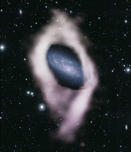
Polar ring galaxies are unique in that they have an outer ring of gas and stars circling the galaxy at right angles to its plane. A composite image of one of these new galaxies is to the right, cropped, reduced and sharpened to post here. From the press release:
Jayanne English, a member of the WALLABY research team and also an expert in astronomy image-making at the University of Manitoba, developed the first images of these gaseous polar ring galaxies using a combination of optical and radio data from the different telescopes. First, optical and infrared data from the Subaru telescope in Hawaii provided the image for the spiral disk of the galaxy. Then, the gaseous ring was added based on data obtained from the WALLABY survey, an international project using CSIRO’s ASKAP radio telescope to detect atomic hydrogen emission from about half a million galaxies.
The creation of this and other astronomical images are all composite because they include information that our eyes can’t capture. In this particular case, the cold hydrogen gas component, invisible to the human eye, is seen in radio “light” using CSIRO’s ASKAP. The subtle colour gradient of this ring represents the orbital motions of the gas, with purple-ish tints at the bottom tracing gas that moves towards the viewer while the top portion moves away. The emission from the ring was separated from the radio emission emanating from the disk of the galaxy using virtual reality tools, in collaboration with Professor Tom Jarrett (University of Cape Town, South Africa).
As the abstract of the research paper notes, the computer models used “show that the data are consistent with PRGs [polar-ring galaxies] but do not definitively prove that the galaxies are PRGs.” There is much uncertainty, as it is difficult to determine the orientation of some rings relative to their galaxy’s plane.
Nonetheless, these result suggest polar ring galaxies might be more common, and thus might help refine the theories of galaxy formation and merger.


