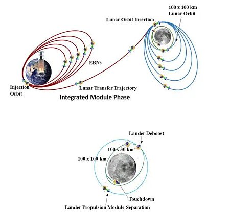
China’s Zhurong rover successfully lands on Mars

The rover landing site for Tianwen-1's rover

The new colonial movement: China’s today successfully landed its Zhurong rover on the northern lowland plains of Mars dubbed Utopia Planitia.

China’s lander and rover began their descent to the surface at about 4:00 p.m. EDT (2000 GMT) by separating from the Tianwen-1 orbiter, which since March has been used to capture imagery of the targeted landing site for study. An aeroshell protected the stacked probes as they plunged into the atmosphere at 3 miles per second (4.8 km per second), generating tremendous heat in the process.

Once inside the atmosphere, while traveling at supersonic speeds, the spacecraft deployed a 2,150-square-foot (200 sq. meter) parachute to slow its approach to less than 328 feet per second (100 m per second). China based the canopy design on the parachutes it has used on Shenzhou missions to return astronauts to Earth.

Finally, the Tianwen-1 lander fired thrusters similar to the type on China’s Chang’e lunar landers to make the final descent. A laser range finder and a velocity sensor helped guide the craft as it hovered at about 328 feet (100 m) to identify obstacles and measure the slopes of the surface before touching down safely.

We don’t yet know the exact touchdown point. The image above is a mosaic of two wide angle photos from the context camera on Mars Reconnaissance Orbiter (MRO), with the white cross marking the spot previously leaked by the Chinese press as the landing site. The white box shows the area covered by the only high resolution MRO photo, as of October 2020. Since then MRO has taken a number of additional high resolution images of this area. The red boxes are the areas covered by the only two high resolution images released by China from its Tianwen-1 Mars orbiter

Note that the rover is actually not yet on the ground. It still sits on the lander. A ramp will be deployed and it will then roll down on the ground to begin what China says is a planned 90 day mission, with the most important data likely coming from the rover’s ground penetrating radar, looking for underground ice.

The flaking and cracked floor of a Martian crater

The flaking and cracked floor of a Martian crater
Click for full image.

Cool image time! The photo to the right, cropped and reduced to post here, was taken on April 1, 2021 by the high resolution camera of Mars Reconnaissance Orbiter (MRO). It shows the central portion of the floor of an unnamed 5-mile-wide crater in northeast corner of Hellas Basin, the deepest large depression on Mars.

The latitude is 33 degrees south, where many glacier features have been identified, especially inside craters.

In this case, the cracked and flaked surface of this crater floor suggests what geologists call exfoliation, “the breaking off of thin concentric shells, sheets, scales, plates, and so on.” On Earth exfoliation generally refers to an erosion process seen on rock faces, though you can see it on other types of materials.

In this Martian crater we appear to be seeing the exfoliation of different ice layers, sublimating away at different rates as they are exposed to the Sun. The layers probably suggest different periods on Mars when snow was falling here, causing the glaciers to grow. The sublimation we see now suggest periods when this region was warmer and the ice was shrinking. Whether we are in such a period now is not yet determined by scientists.

Either way, the photo suggests at least two such cycles, though if we could drill down into this material we would likely find evidence of many more.

Below the fold is a global map of Mars, showing the location of this crater with a red cross in Hellas. The regions surrounded by white borders are areas where many glacial features have been found.
» Read more

Martian glacial run-off?

Mosaic of glacial runoff
For original images click here and here.

Today’s cool image provides us a glimpse at the carved canyons created when the mid-latitude glaciers on Mars were active in the past and slowly flowing downhill into the section of the northern lowland plains dubbed Acidalia Planitia.

The photo to the right is a mosaic of two images taken by the context camera on Mars Reconnaissance Orbiter and rotated, cropped, and reduced to post here. The mosaic shows a region at the very edge of Acidalia Planitia at latitude 43 degrees north.

Below is a close-up of the area in the white box, taken by MRO’s high resolution camera on February 28, 2021, as well as a global map marking the location of this image at the very edge of the glacier country found in the chaos terrain of Deuteronilus Mensae.
» Read more

A crater with wings!

A crater with wings!
Click for full image.

Cool image time! The photo to the right, cropped and reduced to post here, was taken on April 5, 2021 by the high resolution camera on Mars Reconnaissance Orbiter (MRO), and shows a particularly unusual crater in the southern mid-latitudes on the eastern edge of Hellas Basin.

This region east of Hellas is where scientists have spotted many features that suggest buried glaciers. The terraced material inside this crater, as well as the splattered material surrounding it on three sides, are examples of such glacial material. You can also see similar glacial features, though less pronounced, inside the crater to the north.

The global map of Mars below marks the general location of this crater by a blue cross.
» Read more

The atomic hydrogen in Mars’ atmosphere

Atomic hydrogen in Mars' atmosphere, as seen by Al-Amal

The two photos to the right, cropped and reduced to post here, were taken by the ultraviolet spectrometer on the UAE Mars orbiter Al-Amal (“Hope” in English) on April 24 and April 25.

During the 10 hours 34 minutes between the images, the Hope probe moved from being over the planet near noon and viewing the entire dayside (top) to being over the planet at dusk and seeing both the day and night side (bottom). These images will be used to reconstruct the 3D distribution of hydrogen and learn more about its production through the process of splitting water molecules by sunlight and its eventual escape to space.

This data will eventually allow scientists to more precisely measure the total water loss to space that Mars’ experiences annually, which will also allow them to determine approximately how much water the planet has lost over the eons.

A look at Ingenuity’s legs

Link here. This update, written by Bob Balaram, the helicopter’s chief engineer at JPL and Jeremy Tyler, senior aero/mechanical engineer at AeroVironment, outlines the engineering that went into building the helicopter’s legs in order to make sure they could withstand the somewhat hard landings required in the Martian environment.

To withstand these firm landings, Ingenuity is equipped with a cushy suspension system, [with a] distinctive open hoop structure at each corner of the fuselage where the landing legs attach. The lower half of this hoop is a titanium spring that can bend as much as 17 degrees to provide 3.5 inches of motion in the suspension, while the upper half is a soft non-alloyed aluminum flexure that serves as the damper or “shock absorber.” By plastically deforming and fatiguing as it absorbs energy, this flexure acts much like the crumple zone structure of a car chassis. However, unlike a car or the crumple-cushioned landing gear of the Apollo moon landers, Ingenuity’s titanium springs rebound after each impact to pull these aluminum dampers back into shape for the next landing.

The aluminum damper gets a little bit weaker with each cycle as cracks and creases develop. While it would eventually break after a few hundred hard landings, with only a few flights scheduled for this demonstration, that’s a problem we could only dream of having.

This is most likely the failure point that will end Ingenuity’s life, though at the present it is a bit in the future.

Also, the post reveals that JPL subcontracted much of the development of Ingenuity to this company.

AeroVironment designed and developed Ingenuity’s airframe and major subsystems, including its rotor, rotor blades, and hub and control mechanism hardware. The Simi Valley, California-based company also developed and built high-efficiency, lightweight propulsion motors, power electronics, landing gear, load-bearing structures and thermal enclosures for NASA/JPL’s avionics, sensors and software systems.

Good ol’ American capitalism does it again.

OSIRIS-REx on its way back to Earth

OSIRIS-REx today fired its engines and successfully put itself on course for returning its samples from the asteroid Bennu to Earth on September 24, 2023.

The May 10 departure date was precisely timed based on the alignment of Bennu with Earth. The goal of the return maneuver is to get the spacecraft within about 6,000 miles (approximately 10,000 kilometers) of Earth in September 2023. Although OSIRIS-REx still has plenty of fuel remaining, the team is trying to preserve as much as possible for a potential extended mission to another asteroid after returning the sample capsule to Earth. The team will investigate the feasibility of such a mission this summer.

The spacecraft’s course will be determined mainly by the Sun’s gravity, but engineers will need to occasionally make small course adjustments via engine burns.

The science team has already proposed one option, sending the spacecraft on a rendezvous with the potentially dangerous asteroid Apophis shortly after its 2029 close-fly of Earth. It could be that there are other targets as interesting that they need to choose from.

The layers of Mars’ north pole icecap

The layers of Mars' north pole icecap
Click for full image.

Cool image time! The photo to the right, rotated, cropped, and reduced to post here, was taken on April 1, 2021 by the high resolution camera on Mars Reconnaissance Orbiter (MRO). It shows the high cliff edge of the Martian north polar ice cap, and was taken as part of the springtime monitoring for the numerous avalanches that fall from the icecap’s steep edge every spring.

This particular cliff is probably about 1,000 feet high. I cannot tell if the image captured any avalanches on the very steep north-facing cliff. What struck me about this image however was the terraced layers so visible on the west-facing scarp. You can clearly count about eleven distinct and thick layers, each forming a wide ledge.

Each layer represents a different climate epoch on Mars when the ice cap was growing, with new snow being deposited.
» Read more

Ingenuity completes fifth flight; lands in new location

On May 7th, 2021 Ingenuity completed its fifth flight on Mars, this time landing at a new location for the first time.

The robot craft took off at ‘Wright Brothers Field’ – the same spot where the it had risen and landed on all its other flights – but landed at an airfield 423 feet (129 metres) to the south. Landing in a new place is another first for the rotorcraft.

This new landing site places the helicopter in a good position to leap frog along with Perseverance as it moves south in this general area studying the floor of Jezero Crater.

A Martian mud volcano

A Martian mud volcano?
Click for full image.

Cool image time! The photo to the right, rotated, cropped, and reduced to post here, was taken on January 6, 2021 by the high resolution camera on Mars Reconnaissance Orbiter (MRO). It shows a distinct conelike knob in an area of the northern lowland plains of Mars dubbed Acidalia Mensa.

According to this paper [pdf], this is possibly a mud volcano.

Bright pitted cones are common in the northern plains of Mars and have been documented to occur in numerous locations including Acidalia Planitia. Various interpretations of these features have been
proposed but growing consensus in recent literature has favored mud volcanism as the most likely formation mechanism. Mud volcanoes are provocative targets for exploration because they bring to the surface sedimentary materials otherwise inaccessible by normal surface exploration and can aid in reconstructing the sedimentary history of the northern plains. Also, by sampling fluids and sediments from deep in the Martian crust, mud volcanoes may be among the best places to search for ancient and extant life.

A previous cool image post, “Baby volcanoes on Mars”, showed another example in the same general area of Mars.

Though this conclusion is not yet confirmed, the multi-layered apron that surrounds the cone certainly suggests repeated eruptions of muddy water over time.

Scientists have taken many images of this area and cone using MRO’s context camera. (See this image as and example.) All show a very rough terrain, with cracks, fissures, and many smaller cones and knobs. This particular knob however dominates the landscape as one of the largest features. The aprons around it are darker, and appear to have been overlain on top of the nearby rough ground.

If such cones are mud volcanoes, they represent a geological process that is pretty much unique to Mars. There are some comparable features on Earth, but they are rare and do not match exactly.

Ingenuity’s fifth flight later today

The flight path of Ingenuity's fourth flight
The flight path of Ingenuity’s 3rd and 4th flights.
Click for original image.

According to Ingenuity’s engineering team, the helicopter will make its fifth flight today, and unlike the previous flights, it will not return to is initial take-off point, but will instead land to the south, putting it in a better position to tag along with Perseverance. As noted by Josh Ravitch, Ingenuity’s mechanical engineering lead at JPL,

We are traveling to a new base because this is the direction Perseverance is going, and if we want to continue to demonstrate what can be done from an aerial perspective, we have to go where the rover goes.

The map to the right show’s the flight paths of Ingenuity’s third and fourth flights, with the fourth heading south. Based on the data obtained they scouted out its likely landing place for the fifth flight.

[The] targeted takeoff time is 12:33 p.m. local Mars time (3:26 p.m. EDT, or 12:26 p.m. PDT), with data coming down at 7:31 p.m. EDT (4:31 p.m. PDT). Ingenuity will take off at Wright Brothers Field – the same spot where the helicopter took off and touched back down on all the other flights – but it will land elsewhere, which is another first for our rotorcraft. Ingenuity will climb to 16 feet (5 meters), then retrace its course from flight four, heading south 423 feet (129 meters).

This April 30th Ingenuity update by Håvard Grip, Ingenuity’s chief pilot, provides a very detailed explanation of what they are learning about flight on Mars, describing issues of take-off, landing, dust, and maneuvering. Engineers (or any geeks in general) will find Grip’s commentary most interesting.

Breakthrough Listen finds no signs of alien transmissions from 60 million stars

Where are those alien civilizations? Breakthrough Listen, a privately funded project searching for evidence of alien life, has released the first results from its survey of 60 million stars in an area looking towards the galactic center, noting that it found no evidence of any technological transmissions signaling an alien civilization from any of those stars.

The paper can be downloaded here [pdf].

The kind of signals they were looking for were not beacons sent out intentionally by alien civilizations, such as television or radio broadcasts, but unintentional transmissions, such as radar transmissions meant for other purposes but still beamed into space. They found none.

Cats love illusory boxes too

News you can use: A citizen science project has found that cats not only like to climb into real boxes, if you paint the illusion of a square on the ground they will prefer that spot as well.

The illusion at hand was the Kanizsa square: four pacman-like shapes orientated to look like they’re forming four corners of a square, inducing the viewer to perceive a square that isn’t actually there.

…Cognitive ethologist Gabriella Smith from the City University of New York and colleagues recruited humans to set up floor objects for their feline lordlings to choose from – a taped square, a visual illusion of a square, and the same components as the visual illusion, but not arranged to produce a square (the control).

The cat owners were required to film the cats’ response under reasonably controlled conditions to avoid influencing the animals’ choices (this involved wearing sunglasses, too). While over 500 pet cats were originally enrolled, the final data set shrunk down to 30 citizen scientists who managed to complete all the necessary trials.

…”The cats in this study stood or sat in the Kanizsa and square stimuli more often than the Kanizsa control, revealing susceptibility to illusory contours and supporting our hypothesis that cats treat an illusory square as they do a real square,” they found.

Need I add there because of the small sample there is a lot of uncertainty about these results. Though as far as the cats are concerned, there is no uncertainty at all: They rule, and their human servants shall obey.

A river of lava on Mars as long as the Columbia

Lava flow in Kasei Valles
Click for full image.

I’ve said it before and I’ll say it again. Mars is strange, Mars is wonderful, but above all, Mars is alien. Today’s cool image illustrates this saying quite nicely.

The photo to the right, cropped and reduced to post here, was taken on February 1, 2021 by the high resolution camera on Mars Reconnaissance Orbiter (MRO) and was simply labeled “Sacra Sulci Lava”. Sacra Sulci is a section of the Kasei Valles canyon that runs from the north rim of Valles Marineris north about 600 miles where it turns east for about 400 miles to drain out into the northern lowlands plains of Mars. Sacra Sulci is the region where that valley narrows and then turns east.

Apparently the flat smoother areas on the east and south on this image that rise about 60 feet above the surrounding terrain and that also seem to flow around mesas and into canyons are believed to be the edge of a massive lava flow that occurred about 150 to 200 million years ago and drained through Kasei Valles, just like water.

What makes this puzzling, however, is that everything I had read previously about Kasei Valles said that it was thought to have been formed from catastrophic floods of water on early Mars, when the planet was warmer and wetter. In fact, I had posted previously about this theory, and included the map below, taken from figure 8 of this paper [pdf], showing part of the process that some scientists believe occurred.
» Read more

Sunspot update: Sunspot activity continues to exceed predictions

The uncertainty of science: On May 1st NOAA updated its monthly graph to show the Sun’s sunspot activity through the end of April 2021. As I do every month, I have annotated it to show the previous solar cycle predictions and posted it below.

In my sunspot update last month I reviewed in detail the range of predictions by solar scientist for the upcoming solar maximum, noting that based on the higher than expected sunspot activity that has been occurring since the ramp up to solar maximum began in 2020, it appeared that all of their predictions might be wrong. The continuing high activity that occurred in April continued that trend.

» Read more

Fourth flight of Ingenuity set for today; shifting to operational phase

Ingenuity close-up taken by Perseverance April 28th

Even as the Ingenuity engineering team will attempt a fourth flight of Ingenuity, JPL announced today that they and NASA have decided to now shift to operational flights, attempting to duplicate the kind of scouting missions that such helicopters will do on future rovers.

The second link takes you to the live stream of the press conference. The press release is here.

Essentially, they will send Ingenuity on a series of scouting missions after this fourth flight, extending its 30 day test program another 30 days. Its engineers will be working with the Perseverance science team to go where those scientists want to send it. After the fourth and fifth test flights they will fly Ingenuity only periodically, separated by weeks, and send it to scout places Perseverance can’t reach, and have it land at new sites that Perseverance scouted out as it travels.

They have decided to do this because they want to spend more time in this area on the floor of Jezero Crater, for several reasons. First, they are still testing the rover to get it to full working operations. Second, they want to obtain some samples for future pickup at this location. Third, they want to spend an extensive amount of time exploring the floor up to a mile south of their present location.

Finally, the relatively flat terrain is perfect for testing and actually using the helicopter as a scout.

Though the extension is for 30 days, and though the helicopter was not built for long term survival, there is no reason it cannot continue indefinitely until something finally breaks.

Right now they are awaiting the data from the fourth flight, which will arrive at 1:39 pm (Eastern) and will be used to determine what the fifth flight will do, probably a week from now.

The crack that splits the giant volcanoes on Mars

Source of Arsia Mons rille
Click for full image.

Cool image time! In the April download of new images from the high resolution camera on Mars Reconnaissance Orbiter (MRO) was the photo to the right, taken on February 23, 2021 and cropped and reduced to post here, of what was labeled as “Source Region of Possible Rille on South Flank of Arsia Mons.”

Arsia Mons is the southernmost of the string of three giant volcanoes that sit between Mars’ biggest volcano to the west, Olympus Mons, and Mars’ biggest canyon to the east, Valles Marineris. This depression is on the mountain’s lower southern flank, and likely shows an ancient resurgence point where lava once flowed out from beneath the ground to form a rill meandering to the southwest. Today there is no visible resurgence. The floor of the depression appears to be filled with sand and dust, with the surrounding slopes spotted with scattered boulders.

What makes this particular image more interesting is how, when we take a very wide view, it reveals one of the most dramatic geological features on Mars, the 3,500 mile-long crack that caused these three volcanoes, and is actually not obvious unless you know what to look for.

So we need to zoom out. Let us first begin with a mosaic of three wider MRO context camera images, showing the entire rille and the immediately surrounding terrain.
» Read more

Launch of Intuitive Machine’s first lunar lander delayed

Capitalism in space: The first mission of Intuitive Machine’s lunar lander has now been delayed from late this year to early next year.

Intuitive Machines spokesman Josh Marshall said April 26 that the slip was caused by its launch provider. “SpaceX informed Intuitive Machines that due to unique mission requirements the earliest available flight opportunity is in the first quarter of 2022,” he told SpaceNews.

Marshall referred questions about the “unique mission requirements” that caused the delay to SpaceX. That company did not respond to questions from SpaceNews on the topic.

Though it is entirely possible that SpaceX needed to delay the launch, we should be skeptical of this reason. More likely Intuitive has had issues that caused a delay, and is using SpaceX as a cover.

There is a race to become the first privately-built commercial lunar lander. Astrobotics Peregrine lander is still scheduled to launch by the end of the year. We shall see.

Twisted taffy in the basement of Mars

Taffy on Mars
Click for full image.

Cool image time! The photo to the right, taken on March 7, 2021 by the high resolution camera on Mars Reconnaissance Orbiter (MRO) and cropped and reduced to post here, shows us an example of one of Mars’ strangest and most puzzling geological features, dubbed banded or “taffy-pull” terrain by scientists.

Taffy-pull terrain has so far only been found within Hellas Basin, Mars’ deepest impact basin and what I like to call the basement of Mars. Because of the lower crater count in this terrain scientists consider it relatively young, no more than 3 billion years old, according to this 2014 paper, which also notes

The apparent sensitivity to local topography and preference for concentrating in localized depressions is compatible with deformation as a viscous fluid.

At the moment what that viscous fluid was remains a matter of debate. Many theories propose that ice and water acting in conjunction with salt caused their formation, similar to salt domes seen on Earth. Other propose that the terrain formed from some kind of volcanic or impact melt process.

Almost all of the taffy terrain on Mars has been found in the deepest parts of Hellas Basin in a curved trough along its western interior, as shown by the light blue areas in the overview map below.
» Read more

Study: increase in seasonal Martian streaks after 2018 global dust storm suggests dust not water is their cause

Map of Mars showing location of new linneae after 2018 global dust storm
Click for full image.

The uncertainty of science: A just-published survey of Mars following the 2018 global dust storm found that there was a significant increase in the seasonal dark streaks that scientists call recurring slope lineae, providing more evidence that these streaks are not caused by some form of water seepage but instead are related to some dry process.

The map to the right is figure 2 from that paper. The white dots show the candidate lineae that appeared following the 2018 global dust storm. About half were new streaks, not seen previously.

From the paper’s conclusion:
» Read more

Curiosity’s mesa-top view of Gale Crater

The view of Gale Crater from on top of Mont Mercou
Click for full image.

Cool image time! The photo above, reduced slightly to post here, was taken on April 14, 2021 by one of the navigation cameras on Curiosity. The rover was then and is still sitting on top of the twenty foot high outcrop dubbed Mont Mercou.

Last week I had posted a panorama made from images at this viewpoint looking south towards Mount Sharp. Today’s image is from the same place, but now looks north across the floor of Gale Crater at the areas that Curiosity had previously traveled. I think the smallest mesas on the left of this image are the Murray Buttes which Curiosity was traveling through back in 2016, but am not certain.

The mountains in the far distance are the rim of the crater, about 30 miles away.

China names its Mars rover Zhurong, after traditional fire god

The new colonial movement: The Chinese state-run press today announced that it has chosen Zhurong, a traditional Chinese fire god, as the name of the rover that is presently orbiting Mars on its Tianwen-1 orbiter and is targeting a landing sometime in mid-May.

They note that this name matches well with the Chinese name for Mars, “Huo Xing,” or fire star.

The announcement provided little additional information, other than stating that the prime landing site is in the previously announced Utopia Planitia region, which suggests the high resolutions images being taken by Tianwen-1 (unreleased by China) continue to show no reason to change that target.

Gale Crater’s small mesas were formed by wind, not liquid water

Route through Murray Buttes
The Murray Buttes. Click to see August 11, 2016 post.

The uncertainty of science: Though Curiosity has found apparent evidence of past liquid water during its early travels on the floor of Gale Crater, scientists have now concluded that the first small mesas and buttes it traveled past back in 2016, dubbed the Murray Buttes, were not formed by the flow of liquid water but by wind reshaping ancient sand dunes. From the press release:
» Read more

Jupiter’s changing and unchanging Great Red Spot

The changing Great Red Spot of Jupiter
Click for full figure.

In a paper published in March in the Journal of Geophysical Research: Planets, scientists (using images from amateurs, the Hubble Space Telescope, and Juno, scientists) have mapped out the interactions between Jupiter’s Great Red Spot, the longest known storm on the gas giant, and the smaller storms that interact with it as they zip past.

The series of images to the right come from figure 5 of their paper, showing the Spot over a period of three days. The Spot in these images is about 9,000 miles across, less than half the size it had been back in the late 1800s.

The black arrows mark the shifting location and shape of one smaller vortice as it flowed past the Spot from east to west along its northern perimeter, ripping off portions of the Spot as it passed. From the paper’s absract:

During its history, the [Great Red Spot] has shrunk to half its size since 1879, and encountered many smaller anticyclones and other dynamical features that interacted in a complex way. In 2018–2020, while having a historically small size, its structure and even its survival appeared to be threatened when a series of anticyclones moving in from the east tore off large fragments of the red area and distorted its shape. In this work, we report observations of the dynamics of these interactions and show that as a result the [Spot] increased its internal rotation velocity, maintaining its vorticity but decreasing its visible area, and suffering a transient change in its otherwise steady 90‐day oscillation in longitude.

…From the analysis of the reflectivity of the [Spot] and flakes and model simulations of the dynamics of the interactions we find that these events are likely to have been superficial, not affecting the full depth of the [Spot]. The interactions are not necessarily destructive but can transfer energy to the [Spot], maintaining it in a steady state and guaranteeing its long lifetime.

In other words, the changes seen only involved the Spot’s cloud tops, even if those tops were many miles thick. The storm itself is much deeper, with its base embedded strongly inside Jupiter and largely unaffected by these passing smaller storms.

Why the Spot exists and remains so long-lived remains an unsolved mystery.

Bumps and holes in the Martian mid-latitudes

Bumps and holes in the Martian mid-latitudes
Click for full image.

Today’s cool image to the right, taken on January 6, 2021 by the high resolution camera on Mars Reconnaissance Orbiter (MRO) and cropped and reduced to post here, focuses on what appears to be a volcanic bulge on the southeastern edge of the great Tharsis Bulge, home to Mars’ biggest volcanoes.

The terrain gives the appearance of hard and rough lava field, ancient and significantly scoured with time. The bumps and mounds suggest nodules that remained as the surrounding softer material eroded away. The holes suggest impact craters, but their relatively few number suggest that this ground was laid down in more recent volcanic events after the late heavy bombardment that occurred in the early solar system about 4 billion years ago. Since it is thought that the big Martian volcanoes stopped being active about a billion years ago, this scenario seems to fit.

However, the terrain also has hints of possible glacial features, as seen in the large crater-like depression in the image’s center. Below is a zoom in to that crater to highlight the flowlike features in its southern interior.
» Read more

Perseverance technology experiment produces oxygen from Mars’ atmosphere

An engineering test experiment dubbed MOXIE on the Perseverance rover has successfully produced oxygen from the carbon dioxide in the Martian atmosphere, a technology that will be essential for future human missions.

MOXIE (Mars Oxygen In-situ Resource Utilization Experiment), a small, gold box-shaped instrument on the rover, successfully demonstrated a solid oxide electrolysis technology for converting the Martian atmosphere to oxygen. The atmosphere on Mars is about 95% carbon dioxide.

MOXIE’s first oxygen run produced 5.4 grams of oxygen in an hour. The power supply limits potential production to 12 g/hr — about the same amount that a large tree would produce.

…The oxygen production process starts with carbon dioxide intake; inside MOXIE, the Martian CO2 is compressed and filtered to remove any contaminants. It is then heated, which causes separation into oxygen and carbon monoxide. The oxygen is further isolated by a hot, charged ceramic component; the oxygen ions merge into O2. Carbon monoxide is expelled harmlessly back into the atmosphere.

Human missions to Mars will not just need oxygen to breath. They will need it to provide the fuel for leaving the planet and returning to Earth, since it will be very impractical and expensive to bring everything they need with them. For colonization and planetary exploration to truly happen future space-farers must live off the land.

Glacial layers in a northern crater on Mars

Crater filled with many layered glacial features
Click for full image.

Cool image time! The photo to the right, cropped to post here, was taken by the high resolution camera on Mars Reconnaissance Orbiter on March 6, 2021, and shows a mid-latitude crater in the northern lowland plains of Mars with what appear to be layered glacial features filling its interior.

The theory that scientists presently favor for explaining many of the features we see on Mars is based on many climate cycles caused by the wide swings the planet routinely experiences in its obliquity, or rotational tilt. When that tilt is high, more than 45 degrees, the mid-latitudes are colder than the poles, and water ice sublimates southward to those mid-latitudes to fall as snow and cause active glaciers to form. When that obliquity is low, less than 20 degrees, the mid-latitudes are warmer than the poles and that ice then migrates back north.

Such cycles, which are believed to have occurred many thousands of times in the last few million years, will place many layers on the ground in both the mid-latitudes and at the poles. The layers in this crater hint at this.

The overview map below gives some further context.
» Read more

Astronomers detect largest flare ever, on Proxima Centauri

In May 2019 astronomers using the Atacama Large Millimeter/submillimeter Array (ALMA) have detected the largest flare ever seen from any star, including our Sun, on the nearest star, the red dwarf Proxima Centauri.

The detection was 100 times stronger than the Sun’s typical flares.

In May 2019, Proxima Centauri ejected a violent flare that lasted just seven seconds, but generated a surge in both ultraviolet and millimeter wavelengths. The flare was characterized by a strong, impulsive spike never before seen at these wavelengths. The event was recorded by five of the nine telescopes involved in the study, including the Hubble Space Telescope (HST) in ultraviolet, and ALMA in millimeter wavelengths. “The star went from normal to 14,000 times brighter when seen in ultraviolet wavelengths over the span of a few seconds,” said MacGregor, adding that similar behavior was captured in millimeter wavelengths by ALMA at the same time.

Red dwarfs are known to issue very powerful flares, a high solar activity that would likely make life as we know it impossible on any Earth-sized planet in its habitable zone, since the star’s small size and dimness requires that zone to be so close to the star. This powerful flare only cements this reality. The exoplanets that have been found circling Proxima Century will therefore not be great places for life, though building the first interplanetary colony there might make sense.

The upcoming first launch of China’s space station

The Chinese Space Station

The new colonial movement: Later this month, on April 29th, China will use its Long March 5B rocket to launch the first module of its space station, dubbed Tianhe, thus beginning the assembly over the next year or so of their first space station, with ten more launches planned in that short time span.

The T-shape, 100-metric-ton CSS [Chinese Space Station] will comprise three major modules: the 18-meter-long core module, called Tianhe (“Harmony of the Heavens”), and two 14.4-meter-long experiment modules, called Wentian (“Quest for the Heavens”) and Mengtian (“Dreaming of the Heavens”), which will be permanently attached to either side of the core. As the station’s management and control center, Tianhe can accommodate three astronauts for stays of up to six months. Visiting astronauts and cargo spaceships will hook up to the core module from opposite ends. Both it and Wentian are equipped with robotic arms on the outside, and Mengtian has an airlock for the maintenance and repair of experiments mounted on the exterior of the station. Tianhe has a total of five docking ports, which means an extra module can be added for future expansion. The station is designed to operate for more than 10 years.

Much of the work on this station will be similar to the scientific research done on ISS. One additional science project linked to the station however is far more impressive:
» Read more

Study: U.S. mortality rates suggest background radiation actually beneficial

The uncertainty of science: According to a new study by researchers at Ben-Gurion University in Israel of mortality rates across the entire United States, people that live in regions of higher background radiation have lifespans on average 2.5 years longer.

Background radiation is an ionizing radiation that exists in the environment because of natural sources. In their study, BGU researchers show that life expectancy is approximately 2.5 years longer among people living in areas with a relatively high vs. low background radiation. Background radiation includes radiation emanating from space, and radiation from terrestrial sources. Since the 1960s, there has been a linear no-threshold hypothesis guiding policy that any radiation level carries some risk. Hundreds of billions of dollars are spent around the world to reduce radiation levels as much as possible.

…According to BGU Professors Vadim Fraifeld and Marina Wolfson, along with Dr. Elroei David of the Nuclear Research Center Negev, lower levels of several types of cancers were found when the radiation levels were on the higher end of the spectrum rather than on the lower end. Among both men and women, there was a significant decrease in lung, pancreatic, colon and rectal cancers. Among men, there were additional decreases in brain and bladder cancers. There was no decrease in cervix, breast or prostate cancers or leukemia.

Their data “covered the entire US population of the 3139 US counties, encompassing over 320 million people,” according to their paper’s abstract.

Up until now the assumption has been that any radiation is bad, based not on research but on assumptions gained by the negative consequence of exposure to high radiation. There has been no good data on the consequences of low level background radiation, because it is so hard to gather. The time frames are long and the numbers small, all of which causes the impact of background radiation to be overwhelmed by other factors. This study’s statistical use of the entire U.S. population is an attempt to overcome these obstacles.

This study is statistical, which means it found a correlation between higher radiation and longer lifespans. Correlation however does not prove causation. The study found no direct evidence that humans health benefits from background radiation. We should therefore take these results with a large grain of salt.

At the same time, their extremely large database is quite telling, and adds some weight to their conclusion.

1 74 75 76 77 78 274