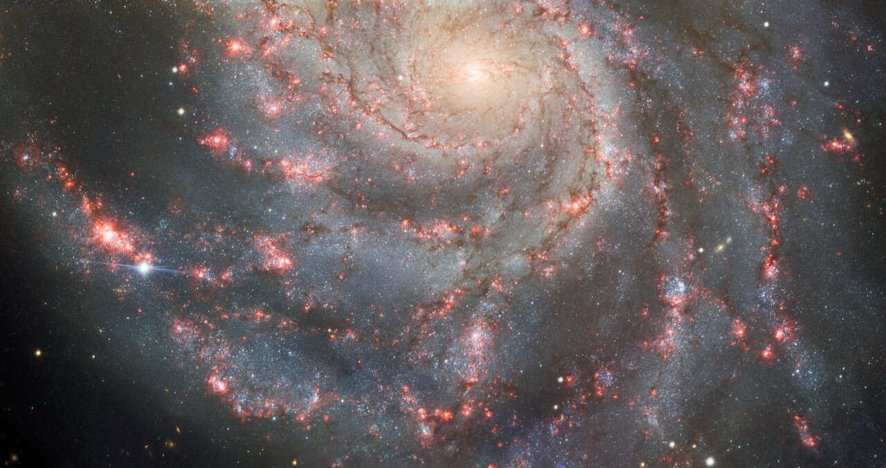
Astronomers propose explanation the dimming of Betelgeuse in 2020

The uncertainty of science: New data has allowed astronomers to propose a more detailed explanation for the dimming of Betelgeuse in 2020 by almost two-thirds.

[T]he dimming was likely to be caused by [one of two] mechanisms, such as a blob of unusually cold matter appearing on the surface of the star in what’s known as a convective cell, or a cloud of dust crossing the line of sight to it.

Now, astrophysicist Miguel Montargès at the Paris Observatory and his collaborators have found that the reason for the ‘great dimming’ was probably a combination of both of those factors

The data suggest that the star spewed out material from a convection cell, which then quickly condensed into dust which acted to block the star’s light. The growing cell itself also was darker, which also contributed to the dimming.

The results, while robust, are still uncertain. While a number of mainstream news sources are claiming the mystery of Betelgeuse’s dimming has been “solved”, that is not how it works. The data now points to an answer, but the data is far from complete, and future observations could very easily change that answer.

New studies: Plexiglass does nothing; masks carry diseases; lockdowns destroyed 40% of all small businesses

Modern science!
How modern politicians apply science!

Three new studies have once again confirmed what common sense and a hundred-plus years of medical research has consistently shown, that the measures mandated by foolish governments and health officials last year to supposedly “stop” or “slow” the spread of COVID-19 did nothing of the sort, and instead likely accomplished the exact opposite.

The studies specifically looked at three of the most popular and imposing actions mandated by either governments or corporations, the installation of plexiglass everywhere, the mandating of mask use, and the draconian lockdowns that shut down whole states for almost a year. In all three cases, the studies found them worse than useless.

First, the plexiglass barriers: Not only has there never been any research documenting the usefulness of the plexiglass barriers that restaurants, convenience stores, and almost all businesses have installed to isolate their workers and customers from each other and thus supposedly prevent the spread of COVID-19, a new study from Boston found that the plexiglass barriers likely increased the risk of infection, because it hampered the flow of air circulation.
» Read more

Hubble in safe mode due to computer problem

A computer failure on June 13th put the Hubble Space Telescope in safe mode, with engineers hoping to have the problem resolved and the telescope back in operation by tomorrow.

NASA is working to resolve an issue with the payload computer on the Hubble Space Telescope. The computer halted on Sunday, June 13, shortly after 4 p.m. EDT. After analyzing the data, the Hubble operations team is investigating whether a degrading memory module led to the computer halt. The team is preparing to switch to one of several backup modules on Wednesday, June 16. The computer will then be allowed to run for approximately one day to verify that the problem has been solved. The team would then restart all science instruments and return the telescope to normal science operations.

The unit itself, while built in the 1980s, was only launched to Hubble in 2009 as part of the last shuttle repair mission.

The Mountains of Mars

The mountains of Mars
Click for full resolution. The highest mountain on the right is about 450 feet high.

Even as the rover Perseverance is beginning its first science campaign on the floor of Jezero Crater, the rover Curiosity about 3,000 miles to the east has begun its climb into the mountains of Mars that surround the central peak of Gale Crater, Mount Sharp.

The mosaic above, made from two images taken by the rover’s right navigation camera (here and here), shows what Curiosity sees ahead. Since my last update on June 4th describing Curiosity’s future travels, the rover’s science team has pushed forward directly uphill towards the entrance to the canyon Gediz Vallis, visible as the gap between the mountains to the right and left in the above mosaic.

The overview map below shows the rover’s approximate present position, with the yellow lines indicating what the above photo is looking at.
» Read more

Rocket Lab wins contract to build two Mars smallsat planetary probes

Capitalism in space: Rocket Lab has won a contract to build two Mars smallsat planetary probe as part of a NASA project.

The project, led by the University of California, will have two probes dubbed Blue and Gold that will launch in 2024 on a Falcon Heavy rocket. The science goal is to place two spacecraft in Mars orbit to provide a more global look at is atmosphere. The financial goal is to show that smallsats built for less can do the same job as larger probes costing millions more.

Boxwork in the basement of Mars

Polygon ridges in Hellas Basin
Click for full image.

Cool image time! The photo to the right, rotated, cropped, and reduced to post here, shows what resembles closely what in Earth caves are called boxwork, polygonal ridges sticking out from the bedrock and usually indicating cracks filled with harder material that resist erosion.

Taken by the high resolution camera on Mars Reconnaissance Orbiter (MRO) on March 23, 2021, what makes this boxwork especially interesting is its size and location. On Earth cave boxwork generally ranges from a few inches to a few feet across. Not only do these Martian ridges range from 100 feet to a half mile in length, they are located at the lowest point in Hellas Basin, the basement of Mars. In fact, this spot is as close as you can get to Mars’ Death Valley, as shown by the overview map below.
» Read more

China releases more images from Zhurong

Zhurong looking north past its lander
Click for full image.

The new colonial movement: Three weeks after its Mars rover Zhurong rolled off its lander to begin its 90 day mission, China yesterday finally released the first high resolution images taken by the rover.

The images included a 360 degree panorama, taken while the rover was still sitting on the lander, an image of both the rover and lander taken by a mini-camera that was dropped from the bottom of the rover, a picture of some interesting nearby boulders to the east, and a picture looking past the lander looking north.

This last picture is above, reduced and annotated by me. The small flat but distinct hill to the north I think is the nearest pitted cone that could be either a mud or lava volcano. That cone is about 3.75 miles away, and though a very enticing target is probably too far away for Zhurong to reach, unless it survives for years past its planned three-month mission, as did the American rovers Spirit and Opportunity.

The closer small ridges and hills just to its right could be the east and west rims of the nearest large crater, about 650 feet wide with a distorted shape, that is visible in the high resolution orbital images taken by both Tianwen-1 and Mars Reconnaissance Orbiter (MRO). This crater is about 1,600 feet away.

Based on these images it appears that once Zhurong rolled off the lander to the east, it immediately turned to the right to move several feet south, where it turned right again to move several feet to the west until it was just to the west of the lander, where it took the picture above. During that last move it dropped the small camera behind it so that it could take the picture showing both the rover and the lander.

These maneuvers and the rover’s position south of the lander and facing west suggest they are going to head to the west, where there are some nearby smaller craters and other interesting features. Whether they eventually go north, with that pitted cone a long term goal should the rover last longer than its planned mission through the end of August, remains entirely unknown.

Zhurong finally located on Mars

Zhurong as seen by MRO
Click for full image.

Though the Chinese had earlier this week released one image taken by their Mars orbiter, Tianwen-1, showing their rover Zhurong on the surface of Mars, they did not provide any specific location information.

This lack has now been filled by a new high resolution image of Zhurong taken by Mars Reconnaissance Orbiter (MRO) on June 6, 2021. This image, cropped to match the Tianwen-1 image and annotated by me to post here, shows the parachute, entry capsule, heat shield, lander, and rover. I have added white dots to distinguish the rover from the lander, which indicate that since the Tianwen-1 orbital image the rover had moved south about 70 feet, suggesting it has been able to travel on the surface.

What this MRO image provides that the Chinese refused to reveal is the latitude and longitude of that landing site, which in turn tells us that the lander put down about 14 miles to the northwest of its targeted landing spot. The mosaic of MRO context camera images below show this landing spot in context with the surrounding terrain.
» Read more

Update on Perseverance’s future travel plans

Perseverance's future travels
Click for full image.

The science team for the rover Perseverance yesterday released a revised map of where they intend over the next few months to send the rover on the floor of Jezero Crater.

The map to the right, cropped and reduced to post here, shows that route.

The first science campaign (depicted with yellow hash marks) begins with the rover performing an arching drive southward from its landing site to Séítah-North (Séítah-N). At that point the rover will travel west a short distance to an overlook where it can view much of the Séítah unit. The “Séítah-N Overlook” could also become an area of scientific interest – with Perseverance performing a “toe dip” into the unit to collect remote-sensing measurements of geologic targets.

Once its time at the Séítah-N Overlook is complete, Perseverance will head east, then south toward a spot where the science team can study the Crater Floor Fractured Rough in greater detail. The first core sample collected by the mission will also take place at this location. After Cratered Floor Fractured Rough, the Perseverance rover team will evaluate whether additional exploration (depicted with light-yellow hash marks) farther south – and then west – is warranted.

Whether Perseverance travels beyond the Cratered Floor Fractured Rough during this first science campaign, the rover will eventually retrace its steps. As Perseverance passes the Octavia B. Butler landing site, the first science campaign will conclude. At that point, several months of travel lay ahead as Perseverance makes its way to “Three Forks,” where the second science campaign will begin.

At that point the rover will begin studying the base of the delta of material that in the far past poured through a gap in the western rim of Jezero Crater.

Europe to fly mission to Venus to study its volcanoes

The European Space Agency yesterday announced that it will fly an orbiter to Venus in 2031, dubbed EnVision, to study the estimated million volcanoes on the surface of that hellish planet.

EnVision will use an infrared spectrometer to seek out hot spots on the surface that could indicate active volcanoes. It will use radar to map the surface, looking for signs of lava flows. Ultraviolet and high-resolution infrared spectrometers will then look for water vapor and sulfur dioxide emissions, to see whether smoldering volcanoes are driving cloud chemistry today.

This data will help determine exactly geologically active Venus’s volcanoes are. Several studies in the past decade using archival data (see here, here, and here) have suggested as many as 37 of those volcanoes are active, but this data remains uncertain.

Evidence of past underground water in the Martian equatorial regions?

Mosaic of strange feature
Click here, here, here, and here for full images.

Today’s cool image, to the right, takes us to the equatorial regions of Mars, a region that today appears quite arid and dry based on all the orbital and rover/lander data so far gathered. The photo and its complex geology however provides us a hint that once liquid water did exist here. At least, that is the hypothesis that scientists presently favor, though making it fit this complex geology is not simple or straightforward.

The mosaic to the right is made from four context camera images taken by Mars Reconnaissance Orbiter (MRO). It shows a very complicated series of depressions — one of which vaguely resembles a crater — that appear to have been washed out by some past erosion process, though that process could not have been that simple because of the fissures and cracks that dominate the floor of the circular feature.

I contacted Chris Okubo of the U.S. Geological Survey, who had requested a high resolution image from MRO of a small part of this mosaic, as indicated by the white box, to ask him what we are looking at. His answer was appropriately noncommittal:
» Read more

Ingenuity completes 7th flight on Mars

Locations of Perseverance and Ingenuity on Mars
Click for interactive map.

Ingenuity yesterday successfully completed its 7th flight on Mars, heading south and landing exactly as planned.

Ingenuity lifted off around 12:34 local mean solar time on Tuesday, which corresponds to 11:54 a.m. EDT (1554 GMT). As planned, the chopper then traveled 348 feet (106 meters) south from its previous location on the floor of Mars’ Jezero Crater, staying aloft for nearly 63 seconds, JPL officials wrote in another tweet. The solar-powered rotorcraft set down at a new airfield, the fourth one it has reached since landing on the Red Planet with NASA’s Perseverance rover on Feb. 18.

Both the rover Perseverance and Ingenuity are traveling south on the floor of Jezero Crater, with the helicopter leapfrogging ahead every few weeks. On the map the red dot indicates Perseverance location, with the green dots Ingenuity’s last three landing sites. They have not yet added to the map exactly where Ingenuity landed yesterday (#7), so I have estimated it based on the information above.

The red outline indicates the region they are planning to explore over the next few months in order to gather a very thorough understanding of the geology of the floor of Jezero Crater. They will eventually head to the northwest towards the cliffs in the upper left, which is the foot of the large delta that flowed in the past into the crater through a gap in its western rim. The route they will take to get there however remains undetermined.

Eroding Martian lava?

Eroding Martian lava?
Click for full image.

Cool image time! The photo to the right, rotated, cropped, and reduced to post here, was taken on April 19, 2021 by the high resolution camera on Mars Reconnaissance Orbiter (MRO). Requested by Colin Dundas of the U.S. Geological Survey’s Astrogeology Science Center in Arizona, the image was entitled “Enigmatic Terrain in Elysium Planitia.” The image is labeled so because, as Dundas explained,

Flood lava is a key part of the feature, best seen at the north and south ends of the image. What’s unusual is the knobby terrain at the center. … I haven’t yet been able to do a more thorough study of these features, so plenty of puzzles remain!

The higher material in the upper right is likely flood lava. A 2016 paper [pdf] led by Dundas on similar features in Elysium Planitia that were not as knobby found their origin somewhat baffling. The evidence suggested that lava, mud, wind, and ice could all be involved in their formation, but the evidence was also not sufficient to eliminate any possibility.

In the case of today’s image, the explanation might also be any of these possibilities. For example, we might be looking at the erosion of the flood lava, exposing harder knobs of different material that had been there before and had been covered by the lava. Or maybe the knobs are simply the last bits of that layer of flood lava that has not yet eroded away.

As always, the overview map provides some context.
» Read more

Juno takes first close-up images of Ganymede since 2000

Ganymede as seen by Juno
Click for full image.

Ganymede as seen by Juno
Click for full image.

On June 7th the Jupiter orbiter Juno made its first close fly-by of Ganymede, taking the first close-up images of this Jupiter moon since the orbiter Galileo flew past in 2000.

The first two images from NASA Juno’s June 7, 2021, flyby of Jupiter’s giant moon Ganymede have been received on Earth. The photos – one from the Jupiter orbiter’s JunoCam imager and the other from its Stellar Reference Unit star camera – show the surface in remarkable detail, including craters, clearly distinct dark and bright terrain, and long structural features possibly linked to tectonic faults.

…Using its green filter, the spacecraft’s JunoCam visible-light imager captured almost an entire side of the water-ice-encrusted moon. Later, when versions of the same image come down incorporating the camera’s red and blue filters, imaging experts will be able to provide a color portrait of Ganymede. Image resolution is about 0.6 miles (1 kilometer) per pixel.

In addition, Juno’s Stellar Reference Unit, a navigation camera that keeps the spacecraft on course, provided a black-and-white picture of Ganymede’s dark side (the side opposite the Sun) bathed in dim light scattered off Jupiter. Image resolution is between 0.37 to 0.56 miles (600 to 900 meters) per pixel.

Both images are to the right, each slightly reduced to post here. These images of this moon of Jupiter, the largest moon in the solar system and about 26% larger than the planet Mercury, reveal many of the same unsolved geological mysteries uncovered when the Galileo orbiter photographed it two decades ago. As I wrote in my Chronological Encyclopedia

Closer inspection of Ganymede revealed a strange topography, including patches of grooved terrain (not unlike the surface of a vinyl record) overlaying other patches of grooved terrain, the different patches oriented in random and totally unrelated directions. Moreover, the surface is overlain by bright and dark patches (the bright patches thought to be caused by water frost) that often had no apparent correspondence to topographical features. Planetary geologists could only scratch their heads in wonderment.

China releases orbital image showing Zhurong on Mars

Zhurong on Mars
Click for original image.

China’s state-run press today released two images taken by its Tianwen-1 Mars orbiter showing its Zhurong rover on the surface of Mars.

Those photos are to the right. The top shows the location prior to the rover’s landing. The bottom, taken on June 2nd, shows the rover and its landing platform, as well as its entry capsule, heat shield, and parachutes.

In the image, taken by a high-resolution camera installed on the orbiter of Tianwen-1 at 6 p.m. on June 2 (Beijing Time), two bright spots are visible in the upper right corner. The larger one is the landing platform, and the smaller one is the Zhurong Mars rover, the CNSA said.

…The dark area surrounding the landing platform might be caused by the influence of the engine plume during landing. The symmetrical bright stripes in the north-south direction of the landing platform might be from fine dust when the landing platform emptied the remaining fuel after landing, the CNSA said.

The bright spots in the center of the image are the back cover of the entry capsule and the parachute jettisoned during the landing. Another bright spot in the lower left of the image is the heat shield of the entry capsule, the CNSA said.

Based on the second photo, it appears that Zhurong has barely moved far from the lander since it rolled off on May 22nd.

And that’s all we really know. The Chinese press release provides no details about how well the rover is functioning, where exactly this location is on the surface of Mars, nor anything else of interest. The rover might be in the region covered by the MRO photos I posted yesterday, but if so the resolution isn’t good enough for me to find the spot. I am sure however that MRO scientists are presently carefully comparing their highest resolution version with these Tianwen-1 images to pinpoint it. They will then follow-up with their own high-resolution images of Zhurong from MRO.

The rover has a planned mission length of 90 Martian days, which runs through the end of August. How much the Chinese government will reveal about its operations and results however remains completely unknown. If it functions as planned expect science papers published in about a year. If not we will only get silence.

Mini-volcanoes (mud or lava?) near Zhurong’s Mars landing site

Mosaic of features near Zhurong's planned landing site on Mars
Click here, here, and here for full images.

Cool image time! Though we still do not know exactly where the Chinese Mars rover Zhurong landed on Mars, we have a rough idea based on the latitude and longitude numbers leaked to the Chinese press in October 2020 and were apparently confirmed by photos taken by the Tianwen-1 orbiter soon after reaching Mars. We also know Zhurong’s engineers wanted to land in the northern lowland plains dubbed Utopia Planitia, a region that is relatively flat and thus makes a safe landing spot for their first attempt to reach the surface of Mars.

The mosaic to the right, rotated and reduced to post here, is made from three context camera images taken by Mars Reconnaissance Orbiter (MRO). The white cross on the right edge is essentially Zhurong’s leaked landing spot. The red box indicates the area covered by one of only two photos that China has released that were taken by its Tianwen-1 orbiter.

The white box in the upper left shows the area covered by today’s cool image, shown below.
» Read more

Curiosity’s dramatic path forward

Curiosity's future travels
Click for full image.

Cool image time! In the coming weeks and months the view from Curiosity is going to give us the most spectacular views of another world since the Apollo astronauts walked on the Moon.

In today’s download of new images from the Mars rover Curiosity was the photo above, reduced to post here. Taken by rover’s right navigation camera, it looks west directly in line with Curiosity’s future travels, and shows that it is now finally entering mountain country.

The overview map below provides the context.
» Read more

New investment capital pours into commercial space

Launcher's E2 engine
Launcher’s 3D printed E2 engine, claimed by the company
to be the highest performance engine for small rockets.

Capitalism in space: Three stories today underlined superbly the robust and steadily growing state of the commercial space industry. Moreover, these stories suggest that this growth will be permanent with almost no limit to its possibilities.

To begin, we have the public appearance of another startup smallsat rocket company, dubbed Launcher.

Small launch vehicle developer Launcher has raised $11.7 million in a Series A funding round, which the company says puts it on a path to reaching orbit with a fraction of the total investment of other launch startups. Launcher said June 2 that the Series A round was co-led by Boost.VC and the company’s founder, Max Haot, both of whom earlier provided seed funding to the startup. Haot invested $5 million using proceeds of a camera company, Mevo.com, that he sold earlier this year to Logitech. Other existing and new investors also participated in the round, which Haot told SpaceNews was oversubscribed.

…Launcher is working on a small launch vehicle called Launcher Light, intended to be similar in performance to Rocket Lab’s Electron, which can place up to 300 kilograms into low Earth orbit. Launcher Light is a smaller version of Rocket-1, the company’s original vehicle, which Haot said in March should speed up development since it will require fewer engines.

The company hopes to launch by ’24, and is also planning another fund-raising round next year to raise an additional $40 million.

Considering the large number of new rocket companies raising capital, who knows if this company will make it. Certainly some will grab market share and survive, but more likely in the coming decade there will be a shake-out where many will either consolidate or disappear, similar to what happened in the early days of the automobile industry.

That so many similar new rocket companies are attracting so many investors however shows that people with money are now convinced that space is the place, and the future there is very bright for profit. And what lends weight to this sentiment are the other two stories today, both of which involve new space startups that are not rocket companies but the kind of ground facilities required by the satellites those rockets launch.
» Read more

Third set of new results from Parker released

The scientists using the Parker Solar Probe on June 2nd released their third set of new results as part of a special issue of the journal Astronomy & Astrophysics.

The latest articles include data analysis, theory, and modeling. Among the major topics covered are magnetic switchbacks first discovered by Parker Solar Probe, the role of waves in heating solar plasma, solar angular momentum, the near-Sun dust environment, and the diversity of small energetic-particle events.

The most interesting paper I think is the one describing data that lends strong weight to the theory, proposed in 1929 by astronomer Henry Norris Russell, that a dust-free zone exists close to the Sun and all stars. From the abstract:

The observed brightness decrease in the axis of symmetry is interpreted as the signature of the existence of a dust density depletion zone between about 19 [solar radii] and 3 [solar radii] which at the inner limit of WISPR’s field of view of 7.65 [solar radii] has a dust density that is ~5% lower than the density at 19 [solar radii], instead of the expected density which is three times if no depletion zone exists.

In plain English, the data shows that from about 1.3 million to 8.2 million miles from the Sun Parker found far less dust than predicted by other models. As the probe continues to lower its orbit and get closer to the Sun with each fly-by these numbers will be better refined, and are likely to in the end prove Russell’s hypothesis.

Problem with Ariane 5 rocket causes Arianespace to delay Webb telescope launch

As first revealed in mid-May, Arianespace has been forced to delay the launch of the James Webb Space Telescope by at least one month because of a problem with the fairing on its Ariane 5 rocket, found during an August 2020 launch.

There have been no Ariane 5 launches since. According to yesterday’s press briefing, however:

“The origin of the problem has been found. Corrective actions have been taken,” Daniel de Chambure, acting head of Ariane 5 adaptations and future missions at ESA, said. “The qualification review has started, so we should be able to confirm all that within a few days or weeks.” He did not elaborate on the problem or those corrective actions, beyond stating that the problem took place during separation of the payload fairing. Industry sources said in May that, on the two launches, the separation system imparted vibrations on the payload above acceptable limits, but did not damage the payloads.

It appears this new delay to Webb’s launch is because two commercial payloads must lift off first before Webb, with the first now scheduled for July. According to Arianespace, it will take two months prep for the next commercial launch, followed by two months prep for the Webb launch. That puts the launch of Webb in November.

Overall this particular delay is slight, only a few weeks, and pales in comparison to the ten years of delays experienced by NASA during development and construction of Webb. It also will add very little to the telescope’s overall budget, which has grown from an original price of $500 million to now about $10 billion.

NASA picks two missions to fly to Venus later this decade

NASA today announced two new missions to go to Venus to study its atmosphere and surface, both scheduled to launch sometime between 2028 and 2030.

One, dubbed DAVINCI+, send a probe into Venus’s atmosphere, both to measure its gases as well as taken the first high resolution images of a unique Venusian geological called “tesserae.” On radar images tesserae regions appear to be high plateaus cross-cut with many sharp ridges.

The second, dubbed VERITAS, will be a radar-orbiter designed to map the planet’s surface at higher resolution than the earlier Pioneer and Magellan radar orbiters. It will also do this:

VERITAS also will map infrared emissions from Venus’ surface to map its rock type, which is largely unknown, and determine whether active volcanoes are releasing water vapor into the atmosphere.

That data will help tell us whether there are now active volcanoes on Venus. The data we presently have suggest it is a planet of many volcanoes, numbering in the millions. That data has also hinted at the possibility that some are active. VERITAS will attempt to find out.

Inexplicable ridges north of China’s Mars rover

Wrinkle ridges in Utopia Planitia?
Click for full image.

Cool image time! The photo to the right, rotated, cropped, and reduced to post here, shows some unusual geology about 450 miles north of the approximate area where China’s Zhurong rover landed in the northern lowlands of Mars. It was taken on April 14, 2021 by the high resolution camera on Mars Reconnaissance Orbiter (MRO).

These scattered ridges remind me of wrinkle ridges, formed when the surface of a place shrinks. With less surface area, the extra material needs somewhere to go, and so ridges are forced up at weak points to release the pressure.

Assuming this hand-waving explanation is true, the next question would be: What causes the shrinking? The overview map below might help provide an answer.
» Read more

Sunspot update: Activity in May continued to exceed predictions

Time for our monthly sunspot update. On June 1st NOAA updated its monthly graph showing the Sun’s sunspot activity through the end of May 2021. Below is that updated graph, annotated as always to show the previous solar cycle predictions.

As has happened now for almost every month since the Sun’s sunspot cycle began to increase following the long and deep minimum in 2019, the activity in June exceeded the numbers predicted by the computer models of NOAA’s panel of solar scientists. While the activity dipped slightly from April, it still was more active than predicted.

» Read more

A lopsided spiral galaxy

Losided spiral galaxy
Click for full image.

For a change, today’s cool image is not from Mars, but instead goes deep into space. The photo to the right, reduced to post here, was taken by the Hubble Space Telescope of the relatively nearby spiral galaxy NGC 2276, located about 120 million light years away. As the caption explains:

The magnificent spiral galaxy NGC 2276 looks a bit lopsided in this Hubble Space Telescope snapshot. A bright hub of older yellowish stars normally lies directly in the center of most spiral galaxies. But the bulge in NGC 2276 looks offset to the upper left.

In reality, a neighboring galaxy to the right of NGC 2276 (NGC 2300, not seen here) is gravitationally tugging on its disk of blue stars, pulling the stars on one side of the galaxy outward to distort the galaxy’s normal fried-egg appearance. This sort of “tug-of-war” between galaxies that pass close enough to feel each other’s gravitational pull is not uncommon in the universe. But, like snowflakes, no two close encounters look exactly alike.

The scientists also note that the bright edge along the galaxy’s north and west perimeter mark regions of intense star-formation. In those same regions astronomers six years ago identified the first medium-sized black hole ever found.

Canada to build a Moon rover for NASA

Canada has signed an agreement with NASA to build an unmanned lunar rover to launch in 2026.

Like NASA,the Canadian government isn’t going to build the rover but will select private companies to design and build for it.

To get the ball rolling on the project, which will explore a lunar polar region, the CSA will soon select two Canadian companies to develop concepts for the rover and its instruments, agency officials added.

Other Canadian gear will reach the moon in the coming years as well, if all goes according to plan. For example, three commercial technologies funded by the CSA’s Lunar Exploration Accelerator Program are scheduled to get a lunar-surface test in 2022 — an artificial intelligence flight computer from Mission Control Space Services; lightweight panoramic cameras built by Canadensys; and a new planetary navigation system developed by NGC Aerospace Ltd.

All three will travel on the first moon mission of the HAKUTO-R lander, which is built by Tokyo-based company ispace, it was announced on Wednesday.

No word on who will launch this new rover, but then it is probably too early for such a decision.

The strange flows in Shalbatana Vallis on Mars

Strange flows in Shalbaltana Vallis
Click for full image.

Cool image time! The photo to the right, rotated, cropped, and reduced to post here, was taken by the high resolution camera on Mars Reconnaissance Orbiter (MRO) on March 31, 2021, and shows a series of very distinct arrowhead-shaped sloping ridges interspersed with hollows flowing down from the southern cliff face of Shalbatana Vallis, one of the larger long meandering drainages flowing into the northern lowlands of Chryse Planitia and north of Valles Marineris.

This location is at 5 degrees north latitude, so nothing we see in the picture is likely glacial or evidence of ice.

So what are we looking at? My guess is that the parallel ridges show us a hint of the original slope of alluvial fill. In the past canyon’s south rim or cliff either did not exist, or was much smaller. Instead the ground mostly sloped gently downhill from the plateau to the canyon floor.

Scientists believe that in the far past catastrophic floods of water flowed through Shalbatana. If a massive flood of water off that rim came down that slope of alluvial fill, it could have pushed into that fill and created the hollows, washing the fill down into the canyon floor and leaving behind the ridges in between.

The overview maps below provide the geographical context.
» Read more

New Chandra mosaic of galactic center reveals spider-web of magnetism

Magnetic field line at the galactic center
Click for full image.

Scientists today released a spectacular panorama of the center of the Milky Way using X-ray data from the Chandra X-ray Observatory and radio data from the MeerKAT radio telescope in South Africa. The panorama reveals a complex web of magnetic field lines emanating out from the supermassive black hole at the center, Sagittarius A* (pronounced A-star).

Below the fold are reduced versions of the full panorama, unlabeled on the left and labeled on the right. The image to the right, reduced to post here, shows just one single example of those magnetic field lines, dubbed G0.17-0.41 and about 20 light years long. This particular filament is the subject of a paper just published in connection with the release of this panorama. From the press release.

A new study of the X-ray and radio properties of this thread by Q. Daniel Wang of the University of Massachusetts at Amherst suggests these features are bound together by thin strips of magnetic fields. This is similar to what was observed in a previously studied thread. (Both threads are labeled with red rectangles in the [full labeled panorama]. The newly studied one in the lower left, G0.17-0.41, is much farther away from the plane of the Galaxy.) Such strips may have formed when magnetic fields aligned in different directions, collided, and became twisted around each other in a process called magnetic reconnection. This is similar to the phenomenon that drives energetic particles away from the Sun and is responsible for the space weather that sometimes affects Earth.

The image below is fascinating to study because of the wealth of detail it includes, not only of magnetic filaments but of other nearby gas clouds and Sagittarius A* itself.
» Read more

Yutu-2 data suggests Moon’s far side is “bombarded more frequently” than the near side

The uncertainty of science: According to a new paper, based on ground-penetrating radar data obtained by China’s Yutu-2 rover on the far side of the Moon, scientists now think that the Moon’s more heavily cratered far side is that way because it actually gets bombarded more frequently than the near side.

From the paper’s abstract:

The Lunar Penetrating Radar (LPR) onboard Yutu-2 can transmit electromagnetic pulses to detect the lunar subsurface structure and properties of the regolith. The relative permittivity, loss tangent and TiO2+FeO content of lunar regolith materials at landing site are constrained with LPR data in this paper. The results indicate that the farside may be bombarded more frequently, leading to different regolith accumulation rates on the lunar nearside vs. farside. [emphasis mine]

The data was accumulated during the rover’s first five months on the surface, during those five lunar days. It found that the regolith at the landing site was about 39 feet thick, much thicker than found at the landing site for Yutu-1 on the Moon’s near side. The difference was partly expected because of the nature of the different locations, but combined with other factors the scientists concluded that a higher bombardment rate on the far side would also help explain the difference.

To put it mildly, this conclusion is uncertain. We only have one data point on the far side, and only a few more on the near side. At the same time, the conclusion is somewhat an example of science discovering the obvious. The very first images of the Moon’s far side, taken The Soviet Union’s Luna 3 lunar probe in 1959, showed the surface much more heavily cratered than the near side, with far less areas of smooth mare. Numerous mapping missions since have confirmed that impression.

And it is also intuitive to come to this conclusion. The near side always faces the Earth, which likely acts to intercept many of the type of meteorite hits that reach the Moon’s far side.

This conclusion however is still intuitive, and an honest scientist will not trust it. That this result from Yutu-2 appears to confirms it is therefore nice.

Glacial flows covering a crater on Mars?

Partially covered crater by glacial flows?

Cool image time! The photo to the right, cropped and reduced to post here, was taken on March 4, 2021 by the high resolution camera on Mars Reconnaissance Orbiter (MRO). It shows an eroded mound that appears to have flows coming off its north and south slopes that fill the surrounding low spots, including half-covering a nearby crater.

The science team for MRO’s high resolution camera chose this picture as their April 28th picture of the day, noting the following:

The objective of this observation is to examine a crater which seems to be in the process of getting covered by flow from a mound. This image, in Protonilus Mensae, may show us characteristics of the covering material: could it be debris-covered glaciers?

Below is a global map of Mars, with this mound’s location in Protonilus Mensae in the northern mid-latitudes indicated by a black cross.
» Read more

1 78 79 80 81 82 280