OSIRIS-REx engineers successfully place sample collector in return capsule

Stowing OSIRIS-REx's sample from Bennu
Click for full image.

OSIRIS-REx engineers have successfully placed the sample collector head holding the material captured from the asteroid Bennu in the return capsule that will bring it back to Earth.

Yesterday, NASA’s OSIRIS-REx mission successfully placed the spacecraft’s sample collector head into its Sample Return Capsule (SRC). The first image shows the collector head hovering over the SRC after the Touch-And-Go Sample Acquisition Mechanism (TAGSAM) arm moved it into the proper position for capture. The second image shows the collector head secured onto the capture ring in the SRC. Both images were captured by the StowCam camera.

Today, after the head was seated into the SRC’s capture ring, the spacecraft performed a “backout check,” which commanded the TAGSAM arm to back out of the capsule. This maneuver is designed to tug on the collector head and ensure that the latches – which keep the collector head in place – are well secured. Following the test, the mission team received telemetry confirming that the head is properly secured in the SRC.

The next step will be to seal the capsule for return to Earth. However, based on the two images above, the sample is now relatively secure, as the opening where material could escape is now held face down in the capsule.

The spacecraft will head back to Earth in March ’21, with the sample capsule landing on Earth on September 24, 2023. I do not know whether it will be possible in the next six months to get new images of the Nightingale touch-and-go site, but have emailed Erin Morton, head of the communications for the science team, and asked. I will update this post when I hear back from her.

Is this the planned landing site of China’s Mars rover?

The prime landing site for China's Mars rover?

According to this Space News article, a report in the Chinese press, since revised to remove the information, had provided precise coordinates on Mars for the prime candidate landing site for China’s Tianwen-1 rover.

[I]nformation published in an article (in Chinese) in the official China Space News publication following launch in July provides a specific primary landing site. The article reported landing coordinates of 110.318 degrees east longitude and 24.748 degrees north latitude, within the southern portion of Utopia Planitia. Online versions of the article have since been edited to remove the coordinates; however, these remain published by sources citing the article.

The mosaic on the right, made up of two images taken by Mars Reconnaissance Orbiter’s (MRO) context camera (found here and here) shows this location with the white cross. The white box is the area covered by the only image taken of this area by MRO’s high resolution camera.

As these photos show, this location, in a part of Mars’ northern lowland plains dubbed Utopia Planitia, is generally smooth and flat, making for a relatively safe landing site. At the same time, it has craters and some ridges and hills that could pose issues.

That the coordinates were removed from the Chinese press story suggests that this might be the prime site, but until Tianwen-1 gets into Mars orbit and begins scouting the site with its own high resolution images, they want to reserve judgement. The spacecraft arrives in orbit in February ’21, and they presently plan to land the rover in May. That gives them three months to scout this location as well as a secondary landing site on the other side of Mars, in the Chryse Planitia northern lowlands [pdf], the same region where Viking 1 and Mars Pathfinder landed.

Once they have done this they will be able to refine the location more precisely.

Scientists finally map Philae’s full route to its final landing site on Comet 67/C-G

Philae's journey across Comet 67/C-G
Click for full resolution image.

Using archival data from Rosetta, scientists have finally been able to map out the full route and all impact points made by the lander Philae on its journey to land on the Comet 67P/C-G in November 2014.

All that was known previously was the location of the first contact, that there had been another impact following the rebound, and the location of the final landing site where Philae came to rest after two hours and where it was found towards the end of the Rosetta mission in 2016 . “Now we finally know the exact place where Philae touched down on the comet for the second time. This will allow us to fully reconstruct the lander’s trajectory and derive important scientific results from the telemetry data as well as measurements from some of the instruments operating during the landing process,” explains Jean-Baptiste Vincent from the DLR Institute of Planetary Research, who was involved in the research published today.

…Analysis of the data revealed that Philae had spent almost two full minutes – not unusual in this very low gravity environment – at the second surface contact point, making at least four different surface contacts as the lander ‘ploughed’ through the rugged landscape. A particularly remarkable imprint, which became visible in the images, was made when the top of Philae sank 25 centimetres into the ice at the side of an open crevice, leaving visible traces of the sample drill and the lander’s top. The peaks in the magnetic field data resulting from the boom movement show that Philae took three seconds to make this particular ‘dent’.

This new data about this particular impact has helped the scientists determine a great deal about the comet’s make-up and density, finding that it is extremely fluffy.

The parameters of surface contact showed that this ancient, 4.5-billion-year-old mixture of ice and dust is extraordinarily soft – it is fluffier than the froth on a cappuccino, the foam in a bathtub or the whitecaps of waves meeting the coast.

They also found that the interior has many voids comprising 75% of the interior, with the “boulders” between having the density of Styrofoam.

Bringing life to the slumping lifeless slopes of Mars

Slumping slopes on Mars
Click for full image.

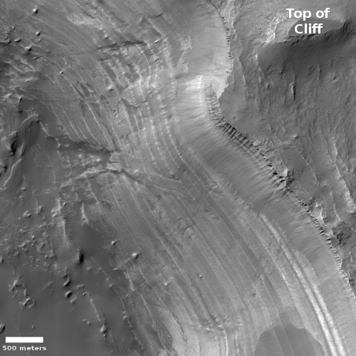
To me, the cool image to the right, cropped and reduced to post here, helps illustrate the most significant difference between Mars and Earth, its obvious lack of life. This lack fundamentally changes the nature of erosion on the Red Planet.

On Earth life covers practically every square foot of the surface, and that life probably does more than anything to reshape the surface, and it does it far more quickly than any geological or meteorological process. For example, even if we are in the most lifeless area of the Sahara Desert, with no plant life, the dunes will still be reshaped and changed simply by the passage of any animal, whether it be a lizard, camel, or human driving a jeep.

On Mars, there is no visible life, and this lack means that any changes we see are solely geological or meteorological in nature. From a scientist’s perspective, the view is clean, all changes wrought solely by inanimate nature, without the added factor of life.

In a sense, Mars gives us a view of what geological and meteorological processes would do on Earth, if the Earth was lifeless.

Today’s image, taken by the high resolution camera on Mars Reconnaissance Orbiter (MRO) on August 29, 2020, exemplifies this. Labeled “Slope Failures in Tempe Terra,” it shows the slow break-up and slumping of debris as it oh-so-slowly falls from higher terrain. The cracks developed as large chunks pulled apart as the material slide downward to the east.

This cracking took a lot of time. On Earth, during that time it would have either been obscured by plant life, or would have been distorted greatly by the traffic of animal life across its surface. Animals would have dug holes, and humans might have reshaped it to build homes and roads. On Mars, none of that happened, so the geology was free to evolve slowly, without interference, and now sits in plain view for scientists to interpret.

Such knowledge will over time strengthen our understanding of Earth geology, because it will give us a better understanding of the influences of life on that geology. Geologists will be better able to separate the influence of life and inanimate natural processes.

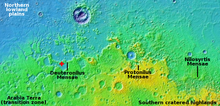
The overview map below helps give the wider context of those Martian inanimate natural processes, on a grand planetary scale.
» Read more

Analyzing the evolving “small” storms in Jupiter’s atmosphere

The vortices in Jupiter's polar regions
Click for full image.

The cool image to the right is another Juno photo of Jupiter enhanced by citizen scientist Gerald Eichstädt. This time Eichstädt also did some analysis of the motions and interactions of many vortices found in the northern polar regions of Jupiter. The image to the right has been cropped and reduced to post here, with the state of Arizona, about 400 by 300 miles in size, added for scale. There is more annotation in the full image.

As Eichstädt writes:

Large vortices in an atmosphere layer of a rotating planet can be roughly split into two classes, cyclonic and anticyclonic vortices.

Based on this rough classification, two interacting vortices can either be of the same or of opposite sign. Tightly interacting vortices of opposite sign tend to mutually propel each other, hence the whole pair, if they are of similar strength and size.

Tightly interacting vortex pairs of the same sign tend to merge. More distant like-signed vortex pairs may essentially repel each other. Interacting vortices tend to create filaments, some of which may split into fragments and further collapse into streets of small eddies.

He also notes that in future orbits Juno will provide closer views of this stormy region, as with the orbit the closest point shifts northward.

Europa Clipper to be delayed because of SLS bottleneck

Because Boeing will be unable to provide an SLS rocket in time for the planned 2024 launch of Europa Clipper, once the probe is completed NASA will be forced to put it in storage.

The problem is that Congress has mandated that the Jupiter probe be launched on SLS, but has only funded the first two Artemis launches to the Moon. Boeing will also need at least three years to build it, meaning that even if the money from Congress appeared today, it would likely not be ready for its ’24 launch date.

In terms of rocket science, right now, Europa Clipper can launch on a commercial vehicle, like SpaceX’s Falcon Heavy or United Launch Alliance’s Delta-IV Heavy rocket, although the mission would then need a longer cruise time to reach its destination.

But in terms of the law, NASA’s hands are tied.

“Because of that, we’re planning to build the Europa Clipper and then put it into storage, because we’re not going to have an SLS rocket available until 2025,” Bridenstine said. “That’s the current plan. I don’t think that’s the right plan, but we’re going to follow the law.”

Though the common sense thing for Congress to do would be to release NASA from this mandate and allow the agency to pick the launch rocket, do not expect that to happen. Congress wants SLS because of all the pork it produces. They will not allow NASA to reduce its reliance on SLS one iota, if they can. Unless pressured publicly (which I think is NASA’s goal with this announcement), Congress will let Europa Clipper sit in a warehouse for years, at a cost of between $36 to $60 million per year, waiting for SLS.

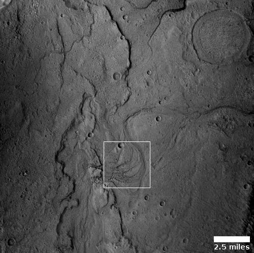
“Flow-like” feature in the Martian lowlands


Click for full image.

Cool image time! The photo to the right, rotated, cropped, reduced, and brightness-enhanced to post here, was taken on July 6, 2020 by the high resolution camera on Mars Reconnaissance Orbiter (MRO).

This is an uncaptioned image, labeled by the MRO science team as a “Flow-Like Feature in Chryse Planitia,” suggesting that they themselves are not exactly sure about what we are looking at. The latitude is 19 degrees north, which is a bit too far south for finding glacial features. Moreover, the craggy look of the ground here does not suggest an eroding glacier, but of eroding bedrock.

We could be looking at a volcanic feature, but this location is very far from Mars’ volcano regions. Nonetheless, another high resolution image, taken just to the west of this photo and given the exact same label, shows similar geology, and does strongly invoke a look of corroded lava flow.

The overview map below gives the context.
» Read more

Water molecules detected on Moon

Using NASA’s SOFIA airborne telescope, scientists have detected for the first time what they think is a very small amount of actual water molecules in areas of the Moon far from the poles.

SOFIA has detected water molecules (H2O) in Clavius Crater, one of the largest craters visible from Earth, located in the Moon’s southern hemisphere. Previous observations of the Moon’s surface detected some form of hydrogen, but were unable to distinguish between water and its close chemical relative, hydroxyl (OH). Data from this location reveal water in concentrations of 100 to 412 parts per million – roughly equivalent to a 12-ounce bottle of water – trapped in a cubic meter of soil spread across the lunar surface.

This result confirms data obtained by India’s Chandrayaan-1 lunar orbiter about a dozen years ago..

There are many caveats. First and foremost, there remain uncertainties about whether they have actually detected water molecules. From their paper’s abstract:

Widespread hydration was detected on the lunar surface through observations of a characteristic absorption feature at 3 µm by three independent spacecraft. Whether the hydration is molecular water (H2O) or other hydroxyl (OH) compounds is unknown and there are no established methods to distinguish the two using the 3 µm band. However, a fundamental vibration of molecular water produces a spectral signature at 6 µm that is not shared by other hydroxyl compounds. [emphasis mine]

This detection points to water for sure, but it remains very uncertain.

The amount is also very small, and is likely localized, as they also note, “within glasses or in voids between grains sheltered from the harsh lunar environment.” If there it will not be useful for future colonists.

The result is important, however, as it increases the likelihood that there is lots of water ice trapped in the permanently shadowed craters near the poles, in amounts that will be useful to future colonists.

New data: The asteroid Psyche is rusting

Using new ultraviolet data from the Hubble Space Telescope, astronomers now believe that the high density asteroid Psyche, thought to be largely metallic, is rusting because of interaction with the solar wind.

Becker observed the asteroid at two specific points in its rotation to view both sides of Psyche completely and delineate as much as possible from observing the surface at ultraviolet (UV) wavelengths.

“We were able to identify for the first time on any asteroid what we think are iron oxide ultraviolet absorption bands,” she said. “This is an indication that oxidation is happening on the asteroid, which could be a result of the solar wind hitting the surface.”

There will be a U.S. probe to Psyche launched in ’22.

Studies: COVID-19 mortality plunging in hospitals

Two new studies have found that the death rate among COVID-19 patients has significantly dropped since the beginning of the epidemic in March.

[One] study, which looked at over 5,000 patients inside the Langone Health system, discovered that in the study timeframe, the mortality rate decreased from 25.6 percent in March to 7.6 percent in August—an 18 percentage point decrease from the start of the pandemic.

According to the data, the median age was seen to have decreased over time, meaning that as time went on, most patients infected with the CCP virus were younger. Although that change seemed to partially explain the decreased mortality rate, it didn’t account for all of it. “Even after risk adjustment for variety of clinical and demographic factors, including severity of illness at presentation, mortality was significantly and progressively lower over the course of the study period,” the study stated.

Patients of all ages experienced a decreased mortality rate. Among those, patients who were at or over the age of 75 saw the largest decrease, from just under 45 percent in the beginning of March to a under 10 percent in August.

The other study confirmed these results. Both suggest a range of factors, most of which centered on doctors learning more about the disease and thus treating it more effectively.

Overall the data confirms once again that COVID-19 is not the plague, and should not be feared in the same way. Yes, like the flu it can kill, but the conditions almost always require the patient to be very old and already badly weakened from other illnesses. For everyone else, the risks are far less, with the likelihood that if you get it, you will easily recover.

Why Do Stupid People Not Realize They Are Stupid?

A bonus second evening pause: Considering some of the foolishness being imposed on free Americans by clearly stupid politicians, their minions in various government bureaucracies, and much of the mainstream media (as illustrated by tonight’s first satirical evening pause), I thought it worthwhile to post this short video, explaining the Dunning Kruger effect. I also thought it especially worthwhile to post, prior to the election.

The solution for everyone, no matter your intelligence, is to be humble, to always consider the possibility you could be wrong. Do that, and you will take the first step in recognizing when you do stupid things.

OSIRIS-REx sample grab so successful they are losing material

The samples from Bennu
Click for full two frame gif movie.

In a briefing today and press release, the OSIRIS-REx science team announced that they estimate that they have gathered a lot of material from the asteroid Bennu, at least 100s of grams, about twice the minimum of what they hoped to get.

In fact, images of the TAGSAM sample grab equipment suggest that there are some larger rocks lodged in its opening (preventing the flap from closing), and that the small movements they have done to photograph it has caused some of the captured material to escape. The image to the right shows this. You can see floating specks and their shadows (the horizontal streaks) that have escaped. At about 9 o’clock you can see a curve in the contact between a lighter material and blackness to its outside, bending towards the center of the TAGSAM. At other exposures they can clearly see a rock there, distorting the shape and thus preventing the flap from closing properly.

Because of this, they are foregoing the spin maneuver that would have weighed the sample, as well as one engine burst that would have slowed the spacecraft’s movement away from Bennu.

This means they will not know the exact amount captured until the sample gets back to Earth. This is a gamble, but they are confident that they have gotten a lot of material. According to Dante Lauretta, the principal investigator, the sample grab-and-go “got very down” into Bennu, as much as 19 inches. He is also confident that they grabbed more than a 100 grams.

They are therefore going to as quickly as possible store the samples in the Sample Return Capsule for return to Earth, beginning on October 27. They need to do a complex series of steps to make this happen, which is why it cannot happen until then.

One more detail: In their simulations prior to the touch-and-go, they had a range of estimates of how deep the spacecraft would penetrate. According to Lauretta, OSIRIS-REx plunged into Bennu at the softest part of that range, telling them that the asteroid is probably much more loosely packed than expected.

Because they are not doing that last engine burst means that they are moving away from Bennu for good. They will not return to the asteroid. Whether they will be able to get post sample grab images of Nightingale is unknown.

India’s Mars orbiter confirms global dust storms speeds atmosphere loss

India’s Mars orbiter Mission (MOM) has confirmed that the periodic Martian global dust storms act to accelerate the loss of the red planet’s atmosphere.

The U.S. orbiter MAVEN found the same thing during the 2018 global dust storm. Moreover, the two orbiters focused on observing different hemispheres (MOM in the morning and MAVEN in the evening), and bot got comparable results.

Was there a catastrophic flood in Kasei Valles on Mars?

Overview map of lower section of Kasei Valles

Figure from paper

In our on-going exploration of Mars using the amazing high resolutions being taken by Mars Reconnaissance Orbiter (MRO), we return today to Kasei Valles, the drainage valley coming down from Mars’ giant volcanoes that I featured only a few days ago. And like that post, we must begin from afar and zoom in to understand what we are seeing in the final cool image.

Kasei Valles is a canyon system is about 1,900 miles long, and would cover two-thirds of the continental United States if placed on Earth. Its north-trending upstream section to the west and south of the area shown on the overview map to the right is thought to have been formed by some combination of glacial and volcanic processes. The downstream west-east section shown in the map instead appears to have been formed by a sudden catastrophic flood, which some scientists have theorized [pdf] occurred when a three hundred long ice dam broke suddenly, releasing the flood quickly across this terrain to create its features. The second map to the right, from their paper, illustrates this hypothesized event.

The white box in 60-mile wide Sharonov Crater near the center of the first map above indicates the location of today’s cool image below. The 1976 landing site of VIking 1 about 420 miles to the east is also indicated.

If you look closely at the first overview map above you can see that the rim of Sharonov Crater appears breached in its southwest quadrant, just to the west of the white box. This breach is less a break and more an area of increased erosion. Regardless, it sure appears that a massive flow pushed through the rim here.
» Read more

Images taken during OSIRIS-REx sample grab on Bennu

Below is an embed of a short eight second video of OSIRIS-REx’s sample grab yesterday from the surface of Bennu, created from 82 images, and covering at high speed the five minutes of approach, contact, and retreat. If you set the speed rate at 0.25, you can get a better view of the whole sequence of events.

From the science team’s press release,

The spacecraft’s sampling arm – called the Touch-And-Go Sample Acquisition Mechanism (TAGSAM) – is visible in the lower part of the frame. The round head at the end of TAGSAM is the only part of OSIRIS-REx that contacted the surface during the sample collection event. In the middle of the image sequence, the sampling head positions itself to contact the asteroid’s surface head-on. Shortly after, the sampling head impacts site Nightingale and penetrates Bennu’s regolith. Upon initial contact, the TAGSAM head appears to crush some of the porous rocks underneath it. One second later, the spacecraft fires a nitrogen gas bottle, which mobilizes a substantial amount of the sample site’s material. Preliminary data show the spacecraft spent approximately 5 of the 6 seconds of contact collecting surface material, and the majority of sample collection occurred within the first 3 seconds.

The TAGSAM is designed to catch the agitated surface material, and the mission team will assess the amount of material collected through various spacecraft activities. After touchdown, the spacecraft fired its thrusters to back away from Bennu. As expected, this maneuver also disturbed the Nightingale site, and loose debris is visible near the end of the image sequence. Preliminary telemetry shows the spacecraft remains in good health. The spacecraft was traveling at 0.2 mph (10 cm/sec) when it contacted sample site Nightingale and then backed away at 0.9 mph (40 cm/sec). [emphasis mine]

At the moment it appears they don’t yet know how much sample they have gotten, but they are very optimistic that they have gotten enough, based on the performance above. On October 24th, when they have gotten far enough away from the asteroid, they give the spacecraft a spin to measure its present mass and compare that to a spin done prior to the sample grab. The difference will tell them how much sample they have captured.

They will also be looking at images of TAGSAM over the next few days, which will also indicate what’s been captured.

The dying COVID-19 epidemic

Daily mortality from COVID-19 in the United States

Daily mortality and number of cases of COVID-19 in California

The time has come for another update on the state of the COVID-19 epidemic in the United States, mostly because the evidence, as shown in the updated graphs to the right, continues to tell us that the epidemic is dying off, both in its deadliness and in its spread, despite what some ignorant and power-hungry politicians from both political parties might be saying.

There is also no evidence yet of a second wave of the virus, something that these same fear-mongering politicians have been touting. Both the national graph to the right as well as the graph showing California’s numbers below show this.

There is, however, ample evidence that the number of COVID-19 deaths in the U.S. has been corrupted in order to inflate the totals. CDC data shows almost no flu deaths in 2020, something that is simply not credible. More likely the totals of COVID-19 deaths are a combination of COVID-19 and flu deaths, with all the deaths assigned to the coronavirus because hospitals get more government money by doing so.

This combination suggests that all told this epidemic is essentially comparable to a normal flu season. The 2020 winter season was simply one in which we were hit with two respiratory diseases, one old and one new, and the two combined to make that season worse than normal.

To confirm what I have just written however I will let my new GP doctor speak for me. Dr. Robert Lending is certified in both internal medicine and clinical lipidology. Two years ago he became disgusted with the way his practice was evolving due to Obamacare and insurance requirements, both of which were forcing him to see an endless string of patients quickly, with no time to spend with each in order to make sure their needs were covered properly. As noted at his webpage,

In 2018, Dr. Lending decided to return to his roots of delivering personalized, one-on-one health care in a more intimate professional setting. He has partnered with Cypress Concierge Medicine and is now one of a limited number of physicians in the region offering membership-based concierge medicine to patients. This provides more time, attention, and VIP service than patients would experience at your average Internal Medicine provider.

As a result, when I called his office to find out if he would consider my own legitimate medical issues that strongly preclude mask use, he very quickly was willing to listen and work with me. For such concierge service you need to pay an annual retainer, which is not cheap, but based on my experience in the past month, it is well worth every penny. For the first time in more than a decade I actually feel I have a real doctor again, who will spend the time to oversee my medical issues and make sure they are taken care of. For example, I can call him anytime, and he answers the phone. With most modern doctors you never get to talk to them directly, except in your short visits. Instead you have to go through go-betweens, who act to protect the doctor rather than treat the patient.

One of Lending’s services is a periodic email he personally writes and sends to his patients, in which he reviews the most recent medical news of the day. Obviously, for the past six months these updates have been focused mostly on the coronavirus, from the perspective of a doctor in the field. I think what he wrote in yesterday’s email about COVID-19 is most pertinent:
» Read more

Penguin highway

An evening pause: Worth watching more than once, if only to escape the insanity of our time.

I can’t help wondering however why they all are walking on this route, and what is it they stop to look at to the right at one point? And why is one crawling on its belly?

Hat tip Jim Mallamace.

Today’s OSIRIS-REx sample grab from Bennu

Nightingale landing site on Bennu
The Nightingale landing site on Bennu, with
OSIRIS-REx superimposed. Click for full image.

Spaceflight Now today published a nicely detailed article summarizing the entire OSIRIS-REx mission to the asteroid Bennu, in anticipation of today’s attempt to grab a sample from that asteroid’s surface.

If you want to understand what is happening today, this article does a nice job of outlining everything.

I have embedded the live stream of the sample grab below the fold. It begins at 5 pm (Eastern) today. Be warned that it will show very little of the actual event, as the spacecraft will not be sending much data back to Earth today, during these operations. All we will really find out is if the grab happened, or was aborted to avoid risks, or occurred but the spacecraft was impacted by flying material during the grab. (Let us hope that this last option does not occur.)

The first images and data will not arrive until tomorrow, to be released during a press conference scheduled for 5 pm (Eastern).
» Read more

The face on Jupiter

The face on Jupiter!

Citizen scientist Gerald Eichstädt has created a two-image blink animation from Juno images of Jupiter that shows the changes in the two oppositely rotating storm vortices, shown on the right. As he notes.

Two vortices or eddies, one cyclonic, the other one anticyclonic, can propell themselves mutually and slowly within the overall context they are embedded in.

…The rotation of the two vortices is perceptible in the image sequence taken within nine minutes. The cyclonic eddy is located at the left, the anticyclonic one at the right. The motion of the vortex pair, however, is too slow to be resolved. But the morphology of the cloud tops points towards a relative upward motion in this rendition.

That the two storms also invoke face I am sure also had something to do with his decision to showcase this data. Unlike the face on Mars, this face is real, though relatively temporary. It will eventually break apart as Jupiter’s storms evolve.

The animation can be seen at the link.

The edge of Martian chaos

Overview map of end of Kasei Valles

For today’s cool image, we are going to start from afar and zoom in, because I think that might be the best way to gain at least a rudimentary understanding of the strange geology visible at this one particular Martian location.

The first image, to the right, is the overview map. The red cross indicates our target, a chaotic canyon that flows into the larger Kasai Valles, one of Mars’ largest and longest canyons and possibly only exceeded in size by Valles Marineris. This part of Kasai is near its end, where it drains out into the vast northern lowland plains of Mars.

The second image, below, comes from the wide angle camera on Mars Reconnaissance Orbiter (MRO).
» Read more

Modern science: Celebrating a “high priestess” instead of data

The corruption of modern science and our intellectual class was well illustrated today by the following headline and article in the peer review journal Science:

Act now, wait for perfect evidence later, says ‘high priestess’ of U.K. COVID-19 masking campaign

From the article’s lead:

In May, when several prominent U.K. scientists pushed back against a Royal Society report recommending face masks to help control the spread of COVID-19, Trisha Greenhalgh was furious. The scientists argued there was insufficient support in the scientific literature for the efficacy of masks, and the U.K. government, following their lead, declined to mandate masks for the general public.

“The search for perfect evidence may be the enemy of good policy,” Greenhalgh, a physician and expert in health care delivery at the University of Oxford, fumed in the Boston Review. “As with parachutes for jumping out of airplanes, it is time to act without waiting for randomized controlled trial evidence.” [emphasis mine]

The highlighted words have been the typical argument of the global warming crowd for decades. “We can’t wait for evidence! We need to act now before it’s too late!”

Moreover, she — along with the writer of this Science article — also copies another global warming dishonest tactic, posing a false argument by claiming that the opposing scientists requried a “randomized controlled trial” to demonstrate the usefulness of masks. This is an absurd misstatement, as it ignores decades of research that already exists and was referenced by those opposing scientists, that showed that mandating widespread mask use was generally a bad idea, and would accomplish nothing good.
» Read more

Update on InSight’s mole: It is now underground

InSight's mole now completely buried
Click for full image.

An update today on the mole digging tool on the Mars lander InSight has revealed that the mole appears to finally be completely buried, though it remains unclear whether its most recent digging effort had succeeded in digging downward.

We found that during the first two rounds of hammering and during the first half of the third round of hammering, the scoop went further into the sand. Since the Mole was hidden under the scoop, the penetration of the probe itself could not be observed directly.

During the hammering, the flat tether running to the probe moved considerably, but these could only be clearly identified as forward movements during the hammering on 22 August. Overall, we could estimate from the movements of the scoop that the Mole moved at most one centimetre further into the ground. It was interesting to observe that during the second half of the round of 250 hammer blows on 19 September, the scoop did not go any further, probably because it encountered duricrust. This was certainly a desired outcome, as it allowed a second Free Mole Test to be conducted. In fact, the probe continued to move according to the movements of the tether, but it could not be clearly determined that these movements brought the Mole deeper into the ground.

The image shows InSight’s arm above the filled hole, with the mole’s flat tether coming out of the ground.

They are now going to fill the hole more, and then press down with the scoop during later drilling efforts to see if this allows the mole to proceed downward. If it fails I’m not sure if there is anything else they will be able to do to get the mole to work.

Study: Almost impossible to contract COVID-19 on an airplane

New research into the air filtration systems on commercial passenger jets has found that it is almost impossible to contract COVID-19 while on an airplane.

A new military-led study unveiled Thursday shows there is a low risk for passengers traveling aboard large commercial aircraft to contract an airborne virus such as COVID-19 — and it doesn’t matter where they sit on the airplane.

Researchers concluded that because of sophisticated air particle filtration and ventilation systems on board the Boeing 767-300 and 777-200 aircraft — the planes tested for the study — airborne particles within the cabin have a very short lifespan, according to defense officials with U.S. Transportation Command, the Defense Advanced Research Project Agency (DARPA) and Air Mobility Command, which spearheaded the study.

You can read the report [pdf] here. I especially like this quote from their conclusions:

For the 777 and 767, at 100% seating capacity transmission model calculations with a 4,000 viruses/hour shedding rate and 1,000 virus infectious dose show a minimum 54 flight hours required to produce inflight infection from aerosol transmission.

In other words, you can fly around the world more than twice on the same plane, without stopping, without any real risk of getting infected.

Need I add that the use of a mask will likely make no difference either, while probably increasing your chances of catching some disease simply because the long term use of any single mask is unsanitary and almost guarantees it will be carrying pathogens on your face where you breathe?

Fingerprints on Mars!

Fingerprint terrain on the Martian south pole icecap
Click for full image.

No, today’s cool image is not a variation of the absurd “face on Mars” that our alien-obssessed fantasy culture focused on for more than twenty years that turned out to be nothing more than a mesa whose shadows in one image made it look very vaguely like a face.

Instead, today’s cool image is of a very weird Martian geological feature that strongly resembles the whorls and curls seen in all fingerprints, and is thus apply named “Fingerprint Terrain.”

The photo to the right, rotated, cropped, reduced, and annotated to post here, was taken by the high resolution camera on Mars Reconnaissance Orbiter on August 26, 2020. It shows part of the surface of Mars’ south pole residual icecap, about 130 miles from the south pole, at a place where the temporary thin dry ice mantle that arrives every winter with the bulk of it sublimating away with the coming of spring.

The fingerprint in this image shows that sublimation process, with the gaps in dry ice mantle getting wider and larger as you move north, until the ridges between disappear altogether.

But why does it look as it does, like a fingerprint? In other places this sublimation process does not look like this at all. Sometimes we get spiderlike formations. Sometimes we get splatters that suggest geysers. Sometimes the surface sublimates to produce swiss cheese shapes. But why a fingerprint here?

I asked this question of Shane Byrne of the Lunar and Planetary Lab University of Arizona, who had requested this particular image, hoping he and other planetary scientists had investigated this geology and come up with an explanation. His answer illustrates how little we yet know about Mars.

It’s almost definitely some sort of sublimation process, but it hasn’t been well investigated. There are some papers that talk about sublimation landforms on the cap in general and map out where different types are, but nothing that I know that’s specific to the fingerprint terrain.

In other words, why the dry ice cap sublimates away in this manner, at this and other locations, remains unexplained.

I’ll say it again: Mars is strange, Mars is alien, and Mars is therefore a place humans must go.

Biden-Harris campaign staffers test positive for COVID-19

Two campaign staffers in the Biden-Harris presidential organization have now tested positive for COVID-19.

Kamala Harris has suspended in-person events until Monday after two campaign staffers tested positive for COVID, reports the Associated Press. Harris was supposed to travel to the battleground state of North Carolina on Thursday.

The campaign insists that Joe Biden was not exposed to the virus, but he and Senator Harris spent several hours together last week while campaigning in Arizona. According to the report, Kamala’s communications director and a traveling staff member tested positive after that trip.

My purpose in reporting this really very non-news story is to make two points:

One: Despite so-called strict regimens to protect its campaign people from getting infected, including masks, social distancing, and any number of other procedures now popular in our fear-crazed society, none worked. The infection still arrived, as such infections are guaranteed to do.

Two: No one will die from this outbreak. In fact, it is not even clear anyone will get sick. The Wuhan virus does not kill healthy people. Like the flu, the worst it does is make a healthy person sick for a week or so, after which they recover completely and return to normal life.

We need to stop being so afraid of this virus. It is not the boogie-man it is made out to be, no matter what some people say. It is a variation of the flu, worse for the old who are already very sick, but more harmless for the young and the healthy. With that knowledge in mind we should focus on protecting that very narrow threatened population, while letting everyone else return to a normal life that involves no masks, no social distancing, and above all, no fear.

Mercury probe BepiColombo probe flies past Venus

Venus during BepiColombo fly-by
Click for full image.

The two-pronged European and Japanese probe BepiColombo today has completed its first of two fly-bys of Venus on its way to an arrival at Mercury in 2025.

The image to the right is one of 64 taken during the fly-by. The science team has created a movie from those images, showing Venus slide past as the spacecraft slewed to view it. During the fly-by the instruments on board its Japanese and European orbiters, both of which will separate and operate independently once they reach Mercury, gathered data of Earth’s sister planet.

The spacecraft still needs one more Venus fly-by plus six past Mercury to get it on a trajectory that will put it in orbit around Mercury. It has also already completed one fly-by past Earth in this complicated route.

NASA announces broadcast schedule for OSIRIS-REx’s sample grab at Bennu

NASA today announced the broadcast schedule that will be available to the public of OSIRIS-REx’s sample grab at the asterod Bennu on October 20, 2020.

Much of the schedule is NASA’s public relations blather, filled with some good information intermixed with a lot of lobbying for the government agency. Much of it will also be the equivalent of watching paint dry, as nothing will be happening quickly.

However, if you wish to watch the important part, tune into NASA TV from 5 to 6:30 p.m on October 20th.

Hosted by Dante Lauretta, OSIRIS-REx principal investigator at the University of Arizona, and Michelle Thaller, science communicator at Goddard, the broadcast will cover milestones in the last 90 minutes leading up to TAG and spacecraft back-away. It will include perspectives from team members and science leaders about the mission’s challenges and accomplishments.

This will be on the public feed. If you find yourself choking on the NASA hype, you can then switch over to the media feed, which will be “A clean feed of the Mission Support Area during TAG [touch-and-go].”

Regardless, the actual attempt will be heart-stopping, because there is a real chance flying rocks from the asteroid’s surface will hit and damage the spacecraft.

Pluto’s mountains are white-capped but with methane not ice

Pluto's white-capped mountains
Pluto’s mountains, capped with methane snow.
Click for full figure.

Scientists now theorize that the white-capped mountains first photographed by New Horizons during its 2015 fly-by of Pluto are capped not with ice but with methane snow, as part of that planet’s methane gas-ice cycle.

The image to the right, from their paper, shows these white-capped mountains on Pluto.

The exact composition of this frost on Pluto was unclear. While researchers identified methane, it was unknown whether it is pure frozen methane, frozen methane diluted with frozen nitrogen or a mix of both. The uncertainty about the frost’s composition made it unclear how it might have formed.

To help solve these mysteries, scientists in this new study examined high-resolution data from New Horizons, focusing on the composition of the frost at high altitudes. This new analysis revealed that the snowcap frost “is almost pure methane ice, with traces of nitrogen ice,” Bertrand said.

The researchers also developed high-resolution computer simulations of Pluto’s climate. They focused on how methane circulates around the dwarf planet. [emphasis mine]

Though their simulations of the methane cycle that produces the caps are reasonable, I purposely highlight the fact that this is what they are, and as such must be treated with great skepticism. We might now know the composition of these snowcaps, but our overall knowledge of Pluto remains to limited to trust blindly any computer model.

Lava cones, fissures, and channels from Olympus Mons

A lava cone, fissure, and channel on Mars
Click for full image.

Cool image time! The photo to the right, cropped and reduced to post here, was taken on June 29, 2020 by the high resolution camera on Mars Reconnaissance Orbiter (MRO). In this one spot we see three obvious volcanic features, all however formed by different processes.

The location of this image is west of Olympus Mons. It sits on the vast lava plain that was laid down by that volcano, the largest in the solar system.

In order of likely occurrence, the cone probably came first. It likely indicates a past eruption coming up from below to create a small volcano.

The shallow meandering channel that sweeps around it to the north and east probably marks a later lava flow coming down from Olympus Mons.

The deeper straight fissure to the south probably came last. It is a graben, a crack caused by the uplift of the entire surface because of pressure from a magma chamber below, causing cracks to form as the surface is stretched.

Three different volcanic events, each probably taking thousands of years, with maybe thousands to millions of years between them. The context map below adds weight to the scale of time and size represented by this one Martian photo.
» Read more

1 81 82 83 84 85 271