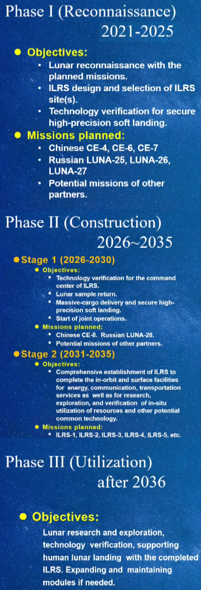
First images from Chang’e-5 on the Moon

Panorama of Chang'e-5 landing site
Click for full image.

The new colonial movement: China’s state-run press has now released several images taken by Chang’e-5 on the lunar surface, including movies showing the landing and the ongoing digging operations.

The photo to the right, cropped and reduced to post here, is part of a fisheye panorama of the entire landing site. I have cropped it to show only the central part. Except for the distant mountain, the terrain is very flat, which is not surprising as this is the Ocean of Storms mare.

Note however how deep the landing pad is pressed into the ground. This gives a sense of the dust layer that covers the surface.

The link above, as well as this link, show additional images as well as the two movies.

Take off is next, followed by the autonomous rendezvous and docking in lunar orbit with the craft that will bring the sample capsule back to Earth sometime around December 16.

Sagging cliffs on Mars

Sagging escarpment on Mars
Click for full image.

Cool image time! On Mars things change, but not like on Earth because the atmosphere is not as thick and there is no flowing water. The photo to the right, rotated, cropped, reduced, and annotated to post here, gives a good example of that slow change. The image was taken on August 29, 2020 by the high resolution camera on Mars Reconnaissance Orbiter (MRO), and shows the high escarpment that in this one place separates the planet’s southern cratered highlands from the transition zone down to northern lowland plains.

In this spot that escarpment, approximately 4,000 feet high, shows signs of avalanches and sagging. In the upper steep section, I point to what looks like a dust avalanche that wiped the slope clear of rough terrain as it rolled downhill. At the bottom of the cliff a large section has separated away. Since this cliff is located at 28 degrees north latitude and is in the midst of the chaos terrain regions I like to dub glacier country, it is very possible that this large section is actually buried glacial ice that in shifting down slope cracked, separating the lower section from the upper.

This particular location is east of an area dubbed Nilosyrtis Mensae (where there is a lot of evidence of glaciers and frozen ice), and about 650 miles north of Jezero Crater, where the rover Perseverance will land on February 18, 2021.

Change’-5 successfully gets sample from drilling

The new colonial movement: According to the state-run Chinese press, Chang’e-5 has successfully obtained its first lunar sample from a 2-meter deep drilled hole.

After making a successful soft landing at 11:00 p.m. BJT on Tuesday, the lander started rolling out its solar panel wings and unlocking some of the payloads onboard to prepare for sample collection.

The lander first drilled a 2-meter-deep hole, digging out soil, and sealed it up at 4:53 a.m. on Wednesday [today]. Next, it will use its robotic arms to scoop up more samples from the lunar surface for backup.

If all goes right, they will collect a second sample from the surface using a scoop, and then the ascent capsule will take off tomorrow. It will then rendezvous and dock with the orbiter and return capsule.

A spray of Martian meteorites

A spray of small secondary impacts
Click for full image.

Cool image time! The photo to the right, cropped and reduced to post here, was taken on October 26, 2020 by the high resolution camera on Mars Reconnaissance Orbiter (MRO). It is what the camera team calls a “terrain sample,” meaning it was not specifically requested by a researcher but was instead chosen by the camera team because they need to regularly take images to maintain the camera’s temperature. When they do this, they try to pick a location that hasn’t been photographed in high resolution previously, and that might have some interesting features. Sometimes the photo is boring. Sometimes they hit pay dirt.

In this case, the photo captured an small impact crater, about 1,300 feet across, surrounded by a spray of secondary impacts. The color portion of the image shows what I suspect are dust devil tracks cutting across a surface that, because of its blue tint, is either rough or has frost or ice within it. At 48 degrees north latitude, the possibility of the latter is high, especially because this location is northwest of the Erebus mountains, where SpaceX has its prime Starship candidate landing zone and where scientists suspect ice is readily available very close to the surface. The overview map below shows this context.
» Read more

LRO looks at Yutu-2

Yutu-2's travels on the Moon through October 2020
Click for full image.

The new colonial movement: The Lunar Reconnaissance Orbiter (LRO) science team today released an update of the travels of China’s Yutu-2 lunar rover, presently operating on the far side of the Moon.

The photo to the right, reduced and annotated to post here, shows the rover’s present position, having traveled about 1,650 feet to the northwest in the 22 months since landing. The goal, according to Yutu-2’s science team, is to get the rover beyond the present ejecta field of debris thrown from a large impact to the north, and reach a basalt covered region about a mile away. At the pace they are setting, about 100 feet per lunar day, it is going to take them about another three years to get there. Whether the rover will last that long is the question, but I suspect they are hopeful, based on the almost two years of operations so far.

If you go to the link you can also see a short movie showing month-by-month where the rover ended up when it shut down for each long lunar night.

Chang’e-5 lands on Moon

The new colonial movement: According to official Chinese reports, Chang’e-5 has successfully soft-landed on the Moon in preparation for its gathering of samples to bring back to Earth.

The Chang’e 5 lander began final descent at 09:58 EST (14:58 UTC) with an expected touchdown 15 minutes later at 10:13 EST (15:13 UTC).

All broadcasts of the event were abruptly stopped just before the landing burn was to begin — throwing the mission into question with CCTV in China at first saying landing coverage would resume at 21:00 EST — an 11 hour delay to the landing. Minutes later, official sources — via social media — proclaimed a successful landing.

Blocking a broadcast like this is very typical of totalitarian governments, and totalitarian societies. Think about that the next time Youtube or Google or Facebook or Twitter or an American university silences speech they don’t like.

As for the lander, all other news reports that I have so far found provide no further details. It appears that all we know comes from a single sentence announcement of success from the Chinese press.

Chang’e-5 now in lunar orbit

The new colonial movement: China’s lunar sample return probe Chang’e-5 has now entered in lunar orbit, with its landing to occur in three days.

Over the next week, the probe, composed of four parts – the orbiter, lander, ascender and Earth re-entry module – will perform multiple complicated tasks on a tight schedule.

The four parts will separate into two pairs. The lander and ascender will head to the moon and collect samples, while the orbiter and Earth re-entry module will continue to fly around the moon and adjust to a designated orbit, getting ready for the docking with the ascender.

The landing operation is expected in three days. Once touched down on the lunar surface, the lander will collect two kilograms of lunar sample.

The plan once on the surface is to gather a sample from the surface as well as from a six-foot deep core sample.

Eroded and possibly wet Lohse Crater

Gully flow near central peak of Lohse Crater on Mars
Click for full image.

Cool image time! Today we take a look at one particular 100-mile-wide crater, Lohse Crater, located in the southern cratered highlands on Mars. The photo to the right, cropped and reduced to post here, focuses in on one of the many eroding gullies found in the mountainous region surrounding the crater’s central peak. Taken on August 20, 2020 by the high resolution camera on Mars Reconnaissance Orbiter (MRO), the full image is centered on that central peak, just off the south edge of this cropped section. This new image is part of a long monitoring campaign, begun in 2007, of this central peak region. For more than six Martian years, scientists have been tracking the numerous gullies found throughout the central peak region to see if there have been any changes.

I focused on this specific gully because I think it illustrates well why planetary scientists are monitoring these gullies. Whatever flowed down from the cliff on the left hit the material on the right hard enough and fast enough to imprint a curve into the material on the crater floor. Moreover, it does not appear to have simply been a landslide, for several reasons. First, the cliff does not appear cut back at the flow’s head, as you would expect if a section had broken off. Second, the material in the flow does not look like debris from an avalanche. In fact, there does not appear to be very much debris in the gully at all.

Third, and most important, the flow appears to originate at the cliff base, kind of what you’d expect if there was seepage coming out of a layer in that cliff face. Kind of what you’d expect on Earth, at a spring!

Was that flow water? This is the big question. Lohse Crater is significant in that it was one of the first locations on Mars [pdf] spotted by Mars Global Surveyor in the late 1990s where gullies were found suggesting some form of regular erosion possibly caused by flowing water. As this 2005 paper then concluded,
» Read more

Orbit of pristine comet in outer solar system is shifting inward

The orbit of a pristine comet that until now has kept it in the outer solar system, where it never got warm enough shed any material, is now shifting inward to join what is dubbed the Jupiter-family of comets, whose orbits are generally within that of Jupiter.

Although it has likely lost some supervolatile ices such as carbon dioxide ice (also known as dry ice) in the outer solar system beyond Jupiter, it is unlikely to have ever been in the inner solar system (where Earth, the other rocky planets, and [Jupiter-family comets] orbit), which is warm enough for water ice to sublime (‘evaporate’ from solid to gas),” Steckloff said. “This means that [Comet 2019] LD2 is a pristine comet, and presents a unique opportunity to observe how pristine [Jupiter-family comets] behave as their water ice begins to sublime for the first time and drive comet activity. Moreover, this transition is likely to finish in only 40 years from now, which is a blink of an eye for astronomy. This means that people alive today will be able to follow this object all the way through its transition into the [Jupiter-family] population.”

In 2019, when 2019 L2 was first identified, it was thought to be an asteroid that had suddenly become active, like a comet. Astronomers soon realized this was a mistake, that it was a comet whose orbit was being changed by its interaction with Jupiter.

The new data refines this conclusion, and confirms that observations of 2019 L2 will provide a lot of information about the make-up of the early solar system. More important, the comet’s orbit will allow for many observations, over a long period of time, unlike most comets that zip around the Sun in a year or so and then are gone.

Giant wind eddies in the sands of Mars

Wind eddies on Mars
Click for full image.

Cool image time! The image to the right, cropped and reduced to post here, was photographed by the high resolution camera on Mars Reconnaissance Orbiter (MRO) on August 5, 2020. It shows a cluster of the crescent-shaped gullies, apparently carved from desert sand by the prevailing winds.

Those prevailing winds here are from the southwest to the northeast. As the wind blows the sand to the east, it hits a more solid object, such as a mountain buried in the sand, which forces the wind and the blown sand to go around, much as water passes a boulder in river rapids. That solid object also causes an eddy to form at its face, the wind forced downward and then around and up, carving out the gullies by lifting the sand at the base of that solid object. The result are these crescent gullies, dubbed blow-outs.

The overview map helps explain why there is so much sand here, enough apparently to bury whole mountains.
» Read more

New data makes past nova too bright, but not bright enough to be supernova

The uncertainty of science: Astronomers, using new data from the Gemini North ground-based telescope, have found that a star that brightened in 1670 and was labeled a nova is much farther away than previously thought, which means that 1670 eruption was far too powerful for a nova, but not powerful enough to make it a supernova.

By measuring both the speed of the nebula’s expansion and how much the outermost wisps had moved during the last ten years, and accounting for the tilt of the nebula on the night sky, which had been estimated earlier by others, the team determined that CK Vulpeculae lies approximately 10,000 light-years distant from the Sun — about five times as far away as previously thought. That implies that the 1670 explosion was far brighter, releasing roughly 25 times more energy than previously estimated [4]. This much larger estimate of the amount of energy released means that whatever event caused the sudden appearance of CK Vulpeculae in 1670 was far more violent than a simple nova.

“In terms of energy released, our finding places CK Vulpeculae roughly midway between a nova and a supernova,” commented Evans. “[T]he cause — or causes — of the outbursts of this intermediate class of objects remain unknown. I think we all know what CK Vulpeculae isn’t, but no one knows what it is.”

Recent research has also suggested that the cause of the eruption was not from the interaction of a binary system with one normal star and a white dwarf, as believed for decades, but possibly a binary system with a brown dwarf, or a red giant star, or two normal stars. All are remain possible, none however have been confirmed.

Glacial eddies on Mars?

Glacial eddies on Mars?
Click for full image.

Cool image time! The photo to the right, cropped and reduced to post here, was taken on August 15, 2020 by the high resolution camera on Mars Reconnaissance Orbiter (MRO). It shows a truly strange bunch of blocks beside a clean flow neatly organized in almost straight parallel lines.

What is going on? This location is at 38 degrees south latitude, a latitude where scientists have found a lot of features that resemble water ice glaciers, generally protected from sublimating away by a thin layer of dust and debris.

A first guess is that the smooth glacial flow at the lower right is disturbing the glacial material next to it, causing it to rip apart and break up. At the same time, the hollowed look of these glacial blocks suggests that the ice below that protective debris layer is also slowly sublimating away, causing the surface to sink.

The wider shot below helps confirm this impression.
» Read more

Study: Asymptomatic and secondary infected individuals do not infect others

A new study published in the journal Nature has found that people who are either asymptomatic or undergoing a secondary illness of COVID-19 are simply not infectious, and don’t give the virus to others.

In other words, it appears that the only time people can infect others is when they have the virus for the first time, and only when they are symptomatic. Lock downs and the use of masks by the healthy accomplish nothing. All you need to do is quarantine the symptomatic patient, as human societies have been doing for centuries and centuries.

To once again emphasize this point, wearing masks if you are healthy and not sick protects no one. Social distancing if you are not sick protects no one. Shutting down businesses, such as reducing capacities at restaurants so they can’t make a profit, protects no one. Curfews protect no one.

When you see someone on a hiking trail, it is not necessary to run ten feet off the trail, put a mask on, and bow your head away in fear and terror of that other person. That they are on the trail guarantees they are not sick. They can’t infect you. And that you are there also means you can’t infect them.

Burn the mask. Smile. Live like a human again. And most of all, stop being afraid all the time.

This very long quote from the study’s discussion section, with the important points highlighted, makes these conclusions very clear:
» Read more

Curiosity data suggests the occurrence of mega floods in Gale Crater

The uncertainty of science: Using Curiosity data a team of scientists are now suggesting that some of the features the rover has seen were created during mega flood within Gale Crater, and this data also requires a rethinking of the present theories of the crater’s geological history.

This case includes the occurrence of giant wave-shaped features in sedimentary layers of Gale crater, often called “megaripples” or antidunes that are about 30-feet high and spaced about 450 feet apart, according to lead author Ezat Heydari, a professor of physics at Jackson State University.

The antidunes are indicative of flowing megafloods at the bottom of Mars’ Gale Crater about 4 billion years ago, which are identical to the features formed by melting ice on Earth about 2 million years ago, Heydari said.

The most likely cause of the Mars flooding was the melting of ice from heat generated by a large impact, which released carbon dioxide and methane from the planet’s frozen reservoirs. The water vapor and release of gases combined to produce a short period of warm and wet conditions on the red planet.

The press release above focuses on the catastrophic floods, but the research paper itself is really much more focused on the need to rethink present hypotheses for explaining the observed geology in Gale Crater. This report notes that they are finding patches of material that could not have been laid down as seen, based on those past theories, and proposes the catastrophic flood event as a possible solution.

In reading the paper however it is evident that even this new hypothesis is based on a limited amount of data, and thus can have holes punched in it as well. This is not to say that the paper is invalid, only that it must be taken with some skepticism. The data being obtained at Gale Crater simply incomplete. Curiosity is following only one path, and has not even left the foothills of Mount Sharp. In order to gain a wider and fuller understanding geologists need to study the entire crater floor, as well as the geology on the mountain.

India’s first mission to Venus delayed a year

The new colonial movement: During a NASA planetary science conference on November 10th, an official of India’s space agency ISRO revealed that they have been forced to delay their first mission to Venus, dubbed Shukrayaan, till 2024.

T. Maria Antonita of the Indian Space Research Organisation (ISRO) detailed the status of the mission to scientists drafting a new 10-year plan for NASA’s planetary science program. Shukrayaan will be India’s first mission to Venus and will study the planet for more than four years.

ISRO was aiming for a mid-2023 launch when it released its call for instruments in 2018, but Antonita told members of the National Academies’ decadal survey planning committee last week that pandemic-related delays have pushed Shukrayaan’s target launch date to December 2024 with a mid-2026 backup date (optimal launch windows for reaching Venus occur roughly 19 months apart).

It appears they are using this extra time to consider a larger launch rocket, which would allow them to increase the orbiter’s capabilities.

Frost on a Martian hillside

Frost on Martian hillside
Click for full image.

Cool image time! The image to the right, cropped to post here, was taken on August 27, 2020 by the high resolution camera on Mars Reconnaissance Orbiter (MRO). It shows a flat-topped mesa in an enclosed canyon dubbed Sisyphi Cavi in the high southern latitudes of Mars during the spring.

Notice the white spots in the gullies on the southern-facing slopes? From what I can gather from a bit of research, these indicate the presence of carbon dioxide frost. It was spring at this location when the photo was taken. At that time, the thin seasonal mantle of dry ice that covers Mars’ the polar regions south to 60 degrees latitude in the winter is sublimating away. This would explain why the frost is only present in the south-facing slopes. Since this is in the southern hemisphere, the south-facing slopes get much less sunlight, and would sublimate away later.

The photo was taken as part of a monitoring program to study this sublimation process. According to this abstract:

Superposition of channel features over and/or through the defrosting CO2 snowpack shows that the channels are active at the present day and probably have fluid flows every spring during the annual defrosting. In itself, this is a significant observation as active fluid flows of any nature have not yet been proven on Mars. However, the ambient temperature at the time of gully activity appears to require a role for CO2 in the formation of the channels, rather than water.

In other words, the coming and going of this dry ice frost each Martian year, in conjunction with the underground water ice also found here, appears to be causing erosion that then creates of the gullies themselves. More details from the abstract in this paper:
» Read more

ESA completes new parachute test for its 2022 Mars rover

On November 9, 2020 the European Space Agency finally conducted the high altitude parachute test of the landing system for its 2022 Mars rover Rosalind Franklin that had been planned for March but had been delayed due to the Wuhan flu panic.

The timeline of the latest test, including extraction and deceleration, went exactly to plan. However, four tears in the canopy of the first main parachute and one in the second main parachute were found after recovery. The damage seemed to happen at the onset of the inflation, with the descent otherwise occurring nominally.

The team are now analysing the test data to determine further improvements for the next tests. Planning is underway for future tests in the first half of next year, to ‘qualify’ the complete parachute system ready for launch in September 2022.

Overall they consider the test a success, though the damage issues must be solved before the ’22 launch. Based on this test it also appears that the ESA made a very wise choice delaying the mission from launch this year, as its parachute system was clearly not ready.

Study: Children are so immune to COVID-19 that even after extensive exposure they test negative

A new study has now confirmed what the very early research had suggested, finding that even when children are repeatedly exposed to the COVID-19 virus, they not only develop no symptoms, they also test negative to the virus.

The research, led by the Murdoch Children’s Research Institute (MCRI) and published in Nature Communications, showed that despite close contact with symptomatic infected parents, including one child sharing the parents’ bed, the children repeatedly tested negative for COVID-19 and displayed no or minor symptoms.

MCRI’s Dr Shidan Tosif said compared to adults, children with COVID-19 usually have very mild or asymptomatic infection, but the underlying differences between children’s and adults’ immune responses to the virus remained unclear.

In other words, children are completely immune from COVID-19. Moreover, they don’t even get infected, which means they can’t even give anyone else the disease. There is absolutely no reason not to reopen all schools immediately, allowing children to return to normal activity, without masks.

Granted this study only observed a single family, but its data must not be ignored. Note too that both parents also completely recovered, which is not surprising as this virus doesn’t appear to kill anyone unless they also have other very serious chronic illnesses. Just like the flu.

Study: Cloth masks provide “statistically insignificant” protection

The certainty of the COVID-19 panic: A large Danish study involving about 6,000 people has found that cloth masks provide “statistically insignificant” protection from infection.

From the paper’s conclusion:

The recommendation to wear surgical masks to supplement other public health measures did not reduce the SARS-CoV-2 infection rate among wearers by more than 50% in a community with modest infection rates, some degree of social distancing, and uncommon general mask use. The data were compatible with lesser degrees of self-protection. [emphasis mine]

I highlight the last sentence to nip in the bud the claims I expect from the Chicken Little crowd that will point to that “50%” number as proof that masks work. The last sentence points out that a 50% reduction in infection rate is what you also get by washing your hands and avoiding already infected individuals. The masks themselves make no difference.

The study found that 42 people in the in the mask group got infected, compared to 53 in the non-mask group. Since both groups contained 3,000 people, the percentage infected for both groups was about 2%, with the mask group having slightly less infections.

It is important to note the real scale of the virus as demonstrated by this study. Out of 6,000 participants, all older than 18 with no current or prior symptoms, very few people got infected. No one apparently died.

The study notes that it did not look at the effectiveness of masks worn by sick people. It is possible that in that circumstance the mask could prevent the infected person from transmitting the virus to others, but that requires more study. However, having people wear masks in the presence of a sick person had been the practice where masks were used for decades. And it certainly makes more sense than making millions of totally healthy people mask themselves wherever they go, twenty-four hours a day.

Either way, this study illustrates again that the mask mandates being imposed by edict by political leaders have no basis in science. The mandates do not require proper use, and even if they did it is unrealistic to expect that proper use. And even if the use was proper globally, this study shows that the mask would accomplish nothing.

But hey, it is important to make feel-good gestures, even if those feel-good gestures are pointless and cause our focus to shift away from more important tasks, such as immunizing children from measles. So what children will die unnecessarily from the measles and rubella! We will feel safe.

New model suggests ringed nebula caused by star merger

The Blue Ring Nebula
Click for full image.

Based on a new theoretical model, astronomers now believe that the Blue Ring Nebula, a planetary nebula discovered in 2004 by the Galaxy Evolution Explorer (GALEX), was the result of the merger of two stars that only occurred a few thousand years earlier.

The image to the right, cropped, reduced, and annotated to post here, shows the original GALEX image on top, with a model to illustrate the geometry. The nebula is shaped like an hour-glass, with the rings the wide parts at the top and bottom. We just happen to be looking at it along its axis.

A new study published online on Nov. 18 in the journal Nature may have cracked the case. By applying cutting-edge theoretical models to the slew of data that has been collected on this object, the authors posit the nebula – a cloud of gas in space – is likely composed of debris from two stars that collided and merged into a single star.

While merged star systems are thought to be fairly common, they are nearly impossible to study immediately after they form because they’re obscured by debris the collision kicks up. Once the debris has cleared – at least hundreds of thousands of years later – they’re challenging to identify because they resemble non-merged stars. The Blue Ring Nebula appears to be the missing link: Astronomers are seeing the star system only a few thousand years after the merger, when evidence of the union is still plentiful. It appears to be the first known example of a merged star system at this stage.

When the merger happened it caused the bi-polar jets that formed the hourglass shape.

Venus results suggesting life downgraded

Surprise! Surprise! Further research and review of the recent results that said phosphine existed in Venus’s atmosphere — which for some immediately suggested the presence of life — has found that the phosphine probably doesn’t exist.

[A]lmost immediately, other astronomers began to criticize the results, with four independent studies pointing out questionable methods or failing to reproduce the results.

Now, after reanalyzing their data, the original proponents are downgrading their claims. Even the most favorable interpretation of their data now suggests phosphine levels are at least seven times lower than first reported, making it a much more tentative finding, the authors reported in a preprint posted on 17 November to arXiv.

Also, observations in other wavelengths detected no phosphine, even though it should have been there if the first study was correct. Furthermore, other scientists have noted that the spectrum features detected might not be caused by phosphine. The sulphur dioxide in Venus’s atmosphere could instead be their source.

Even if phosphine is eventually confirmed, that is not the discovery of life on Venus, as so many in the mainstream press claimed. As I noted when this result was first announced, phosphine isn’t life, it is merely a specific inanimate molecule. That on Earth it only exists in connection with life-processes means nothing. Venus is a very alien place, and there could be any number of inanimate chemical processes that we have no experience with or knowledge of that could produce it there. To claim its discovery suggests the existence of life, or even the possibility of life, is simply junk science.

Scientists: Major measles outbreaks likely because of COVID-19 lockdowns

According to a paper published in the peer review journal Lancet, there is a very high likelihood of major measles outbreaks among children worldwide in 2021 — resulting in many unnecessary deaths — due to the shut downs imposed because of the panic over COVID-19.

Lead author Professor Kim Mulholland, from the Murdoch Children’s Research Institute and Chair of the World Health Organization’s SAGE Working Group on measles and rubella vaccines, said that many children have missed out on measles vaccination this year, making future measles outbreaks inevitable. …”The coming months are likely to see increasing numbers of unimmunised children who are susceptible to measles. Many live in poor, remote communities where health systems are less resilient, and malnutrition and vitamin A deficiency are already increasing.”

Professor Mulholland said the COVID-19 pandemic had also had a profound effect on the control of vaccine preventable diseases, with vaccination campaigns paused in the early months of 2020 and routine immunisation services greatly disrupted in many countries.

The WHO estimates that by the end of October, 2020, delayed vaccination campaigns in 26 countries have led to 94 million children missing scheduled measles vaccine doses. [emphasis mine]

Think about it. Because we and our governments panicked and shut down society to protect children from a virus that is not only not contagious among children, it also is practically harmless to them, many children will now die from diseases we know are highly contagious and we know can kill them.

And people accuse me of being heartless because I say the lock downs are senseless, irrational, and a bad idea.

Buried mountain on Mars

Isolated buried mountain on Mars
Click for full image.

Cool image time! The photo to the right, rotated, cropped, and reduced to post here, was taken on August 8, 2020 by the high resolution camera on Mars Reconnaissance Orbiter (MRO). Labeled merely as a “terrain sample,” it is an example of an image taken more for engineering than scientific reasons. No research scientist specifically requested it. Instead, the scientists operating the camera took it because they need to use MRO regularly to maintain the camera’s proper temperature. To do this they periodically take almost random images, but never without trying to pick a location that might have some scientific value.

In this case we get what appears to be an isolated sloping hill. Located at about 15 degrees north latitude, this is not a place where one would expect visible evidence of water, though the gullies on the slopes are intriguing. They almost look like the kind of hillside erosion you see in places where rain falls on desert mountainsides.

Rain can’t be the cause, but nonetheless monitoring these gullies for changes over time would be worthwhile science research. Since it appears no one is presently focused on doing it, anyone interested out there?

This mountain is actually far more isolated than this high resolution image suggests.
» Read more

The Apollo 12 crew’s excursions on the Moon, 51 years ago

In celebration of the anniversary this week of the Apollo 12 mission to the Moon in November 1969, the science team for the Lunar Reconnaissance Orbiter (LRO) have created a wonderful animation showing step-by-step where and when Pete Conrad and Alan Bean walked during their two EVAs on the lunar surface.

That video is below. It highlights strongly the need of any future short-term mission to any planetary landing to have a vehicle on board. Conrad and Bean accomplished a lot during their two four-hour walks, but nowhere near as much as they could have accomplished if they could have driven about on their EVAs. In fact, in the 1960s NASA had already recognized this, and was to put a rover on the last three Apollo lunar landings.

Arecibo’s status appears to be worsening

According to a new engineering report, the condition and status of the Arecibo Observatory’s main antenna, suspended by cables above its giant radio dish, appears very uncertain and to be worsening.

Preliminary analysis indicates the main cable, which failed on Nov. 6, should have easily handled the extra load based on design capacity. Engineers suspect it is likely that the second cable failed because it has degraded over time and has been carrying extra load since August. A final determination could not be made without retrieving and analyzing the second cable.

The engineering firms cannot verify the integrity of the other cables at this time supporting the 900-ton platform. Each of the structure’s remaining cables is now supporting more weight than before, increasing the likelihood of another cable failure, which would likely result in the collapse of the entire structure.

Other wire breaks on two of the remaining main cables have also been observed. [emphasis mine]

If the 900 ton antenna structure that the cables hold up should fall, it will do significant damage to the disk, and will also likely make the cost of repairing the radio telescope prohibitive.

A majestic terraced butte on Mars

Majestic butte on Mars
Click for full image.

Cool image time! The photo to the right, rotated, cropped, and reduced to post here, was taken on September 8, 2020 by the high resolution camera on Mars Reconnaissance Orbiter (MRO). It shows an outstanding terraced butte that would rival any of the similar buttes scattered throughout the Grand Canyon, and is reminiscent especially of Wotans Throne.

What makes this butte intriguing are its terraces, the obvious result of the repeated deposition of new layers across the surface over time, and now exposed by erosion. What caused them?

As always, location provides the clues. First, this butte is found at about 15 degrees north latitude in the vast Arabia Terra transition region between the Martian northern lowland plains and the southern cratered highlands. At that latitude, we are not looking at any recent glacial features. While there might have been ice here once, it hasn’t likely been present, either on the surface or underground, for a very long time.

This conclusion becomes important once we look at the wider photo below, taken by the high resolution camera on the European orbiter Mars Express. This image gives us the immediate context.
» Read more

MAVEN finds water loss on Mars faster than expected

New data from the Mars orbiter MAVEN has found that the water on Mars moves into the upper atmosphere where it is lost to space much faster than expected.

It had previously been believed that Mars’ water loss only occurred in the lower atmosphere, which is a much slower process. Scientists had also believed that water on Mars would behave as it does on Earth, where temperatures and the atmosphere act to block it from reaching the upper atmosphere where it can easily and quickly be lost to space. Instead, MAVEN found a lot of water in the upper atmosphere.

When the team extrapolated their findings back 1 billion years, they found that this process can account for the loss of a global ocean about 17 inches deep. “If we took water and spread it evenly over the entire surface of Mars, that ocean of water lost to space due to the new process we describe would be over 17 inches deep,” Stone said. “An additional 6.7 inches would be lost due solely to the effects of global dust storms.”

During global dust storms, 20 times more water can be transported to the upper atmosphere. For example, one global dust storm lasting 45 days releases the same amount of water to space as Mars would lose during a calm Martian year, or 687 Earth days.

This data reinforces the theories that Mars once had liquid water on its surface, either as intermittent oceans or as lakes and rivers. Or it suggests that Mars once had a lot more glaciers than it does now, reinforcing a competing theory that glaciers formed the Martian features we on Earth routinely associate with flowing water.

Hubble sees too much infrared energy from gamma ray burst

The uncertainty of science: During a short gamma ray burst (GRB) that was observed in a distant galaxy on May, astronomers were baffled when measurements from the Hubble Space Telescope detected ten times more near infrared energy that they predict from this type of GRB.

GRBs fall into two classes. First there are the long bursts, which are thought to form from the collapse of a massive star into a black hole, resulting in a powerful supernova and GRB. Second there are the short bursts, which scientists think occur when two neutron stars merge.

The problem with this GRB is that though it was short and somewhat similar to other short GRBs across most wavelengths, in the near infrared Hubble detected far too much energy.

“These observations do not fit traditional explanations for short gamma-ray bursts,” said study leader Wen-fai Fong of Northwestern University in Evanston, Illinois.

…Fong and her team have discussed several possibilities to explain the unusual brightness that Hubble saw. While most short gamma-ray bursts probably result in a black hole, the two neutron stars that merged in this case may have combined to form a magnetar, a supermassive neutron star with a very powerful magnetic field. “You basically have these magnetic field lines that are anchored to the star that are whipping around at about a thousand times a second, and this produces a magnetized wind,” explained Laskar. “These spinning field lines extract the rotational energy of the neutron star formed in the merger, and deposit that energy into the ejecta from the blast, causing the material to glow even brighter.”

What is intriguing about their theory is that this merger of two neutron stars simply resulted in a larger neutron star, not a black hole. This new neutron star was also a magnetar and pulsar, but unlike a black hole, it was a still-visible physical object. And yet its creation in this GRB produced more energy.

When GRBs were first discovered, I was always puzzled why so many astronomers seemed to insist there must be a single explanation for them. With time, when two classes of GRBs were discovered, this assumption was then replaced with the equally puzzling insistence that only two types of events explained them.

It seemed to me that that such explosions had too many potential variables, and could easily have a wide range of causes, though all related to the destruction or merger of massive stars. As the data continues to accumulate this now appears increasingly the case.

A field of Martian knobs

Knob field on Mars
Click for full image.

Cool image time! The photo to the right, cropped and reduced to post here, was taken on August 9, 2020 by the high resolution camera on Mars Reconnaissance Orbiter (MRO). Uncaptioned, the image is merely dubbed a “knob field.”

I won’t spend much time trying to explain this geology. It might be related to pedestal craters, but these ridges and mesas don’t really look like those features, since they don’t really stand above the surrounding terrain.

Maybe they are a very ancient field of craters long buried, now partly exposed due to erosion, but also partly buried by wind-blown Martian sand and dust. Once again, that many of their shapes don’t resemble craters discounts this explanation.

The location of this photo is in the southern cratered highlands, as shown by the black cross in the overview map below.
» Read more

1 82 83 84 85 86 274